Cleveland

MarkerMarkerMarkerMarkerMarkerMarkerMarkerMarkerMarkerMarkerMarkerMarkerMarkerMarkerMarkerMarkerMarkerMarkerMarkerMarkerMarkerMarkerMarkerMarkerMarkerMarkerMarkerMarkerMarkerMarkerMarkerMarkerMarkerMarkerMarkerMarkerMarkerMarkerMarkerMarkerMarkerMarkerMarkerMarkerMarkerMarkerMarkerMarkerMarkerMarkerMarkerMarkerMarkerMarkerMarkerMarkerMarkerMarkerMarkerMarkerMarkerMarkerMarkerMarkerMarkerMarkerMarkerMarkerMarkerMarkerMarkerMarkerMarkerMarkerMarkerMarkerMarkerMarkerMarkerMarkerMarkerMarkerMarkerMarkerMarkerMarkerMarkerMarkerMarkerMarkerMarkerMarkerMarkerMarkerMarkerMarkerMarkerMarkerMarkerMarkerMarkerMarkerMarkerMarkerMarkerMarkerMarkerMarkerMarkerMarkerMarkerMarkerMarkerMarkerMarkerMarkerMarkerMarkerMarkerMarkerMarkerMarkerMarkerMarkerMarkerMarkerMarkerMarkerMarkerMarkerMarkerMarkerMarkerMarkerMarkerMarkerMarkerMarkerMarkerMarkerMarkerMarkerMarkerMarkerMarkerMarkerMarkerMarkerMarkerMarkerMarkerMarkerMarkerMarkerMarkerMarkerMarkerMarkerMarkerMarkerMarkerMarkerMarkerMarkerMarkerMarkerMarkerMarkerMarkerMarkerMarkerMarkerMarkerMarkerMarkerMarkerMarkerMarkerMarkerMarkerMarkerMarkerMarkerMarkerMarkerMarkerMarkerMarkerMarkerMarkerMarkerMarkerMarkerMarkerMarkerMarkerMarkerMarkerMarkerMarkerMarkerMarkerMarkerMarkerMarkerMarkerMarkerMarkerMarkerMarkerMarker
2
Marker
Legend
Red (Warning)
Orange (Watch)
Yellow (Advisory)
Green (Normal)
Uninstrumented
Community
Webcam
Instrument
Earthquake Magnitude
0 7+
Earthquake Age
Last 2 Hours
Last 2 Days
Last 1 Week


Facts


  • Official Name: Mount Cleveland
  • Seismically Monitored: Yes
  • Color Code: GREEN
  • Alert Level: NORMAL
  • Elevation: 1730m (5675ft)
  • Latitude: 52.8222
  • Longitude: -169.945
  • Smithsonian VNum: 311240
  • Pronunciation:
  • Nearby Towns:
    • Nikolski 46 mi (73 km) NE
    • Unalaska 158 mi (255 km) NE
    • Atka 184 mi (296 km) SW
    • Akutan 194 mi (312 km) NE
    • Saint George 262 mi (421 km) NE

    Distance from Anchorage: 945 mi (1521 km)

Description

From Miller and others (1998) [1] : "Mt. Cleveland is a stratovolcano that comprises the entire western half of Chuginadak Island, 40 km west of Umnak. Distinctively conical and symmetrical in form, Cleveland is about 8.5 km in diameter and is joined to the rugged, though lower, eastern half of the island by a low, narrow strip of land. Sekora (1973) [2] reports that this strip is dotted with "lava flow, cinder, and ash patches, and conical hills."
"Although it is the tallest member of the Four Mountains group, Mt. Cleveland is reported to lose snow more rapidly than neighboring peaks presumably from anomalous heat generation (Sekora, 1973 [2] , p. 27). Hot springs were noted at the base of a volcano on Chuginadak Island in the 1800's [3] .
"Like many other Aleutian volcanoes, the lower flanks of Mt. Cleveland up to about the 300 m elevation are more irregular and dissected than the upper flanks. The cones on the eastern half of Chuginadak Island are dissected by broad valleys presumably eroded in part by glaciers; in contrast, the upper cone of Mt. Cleveland is virtually undissected."

Name Origin

Mount Cleveland was named in 1898 by John A. Flemer, U.S. Coast and Geodetic Survey, possibly after Stephen Grover Cleveland, the 22nd and 24th President of the United States (Orth, 1971).


References Cited

[1] Catalog of the historically active volcanoes of Alaska, 1998

Miller, T. P., McGimsey, R. G., Richter, D. H., Riehle, J. R., Nye, C. J., Yount, M. E., and Dumoulin, J. A., 1998, Catalog of the historically active volcanoes of Alaska: U.S. Geological Survey Open-File Report 98-0582, 104 p.

[2] Aleutian Islands National Wildlife Refuge, Wilderness Study Report, 1973

Sekora, P., 1973, Aleutian Islands National Wildlife Refuge, Wilderness Study Report: U.S. Department of the Interior, Fish and Wildlife Service, Bureau of Sport Fisheries and Wildlife.

[3] Thermal springs of the United States and other countries of the world - a summary, 1965

Waring, G. A., 1965, Thermal springs of the United States and other countries of the world - a summary: U.S. Geological Survey Professional Paper PP 0492, 383 p.

Current Activity

No new updates for Cleveland volcano since July 8, 2024, 1:06 pm.

Webcams

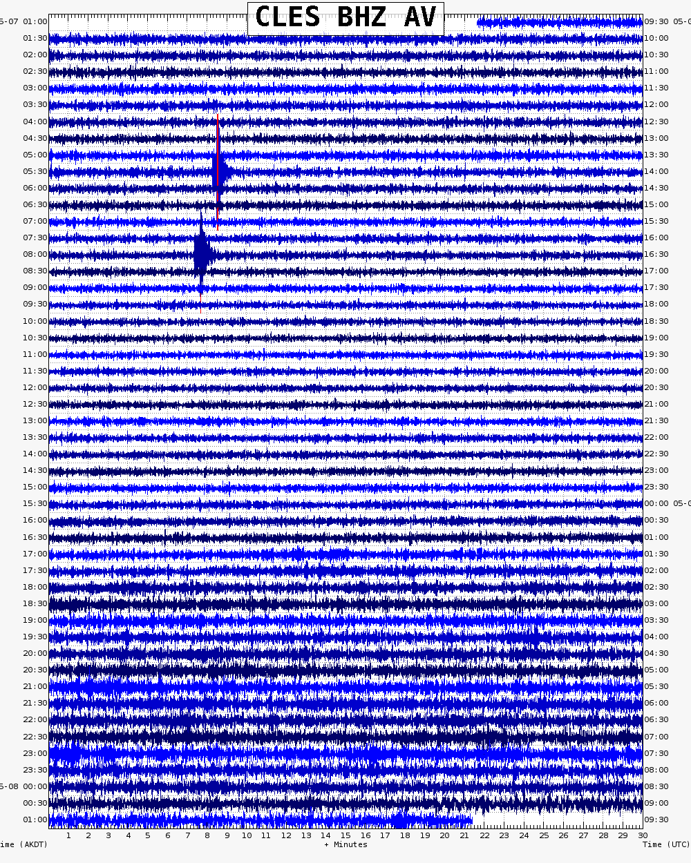
Webicorder

Color Code Timeline

Reported Activity

Modern Eruptions

Cleveland

Cleveland Eruption Timeline

Grewingk (1850, translated 2003 by Fritz Jaensch) reports "Tanak-Angunak active in 1774." There is some confusion as to whether "Tanak-Angunach" refers to Carlisle volcano or Mount Cleveland. From Miller and others (1998): "Various names were applied to Carlisle on early hydrographic charts, including Uliaga, Kigalgin and variants thereof; it was also sometimes referred to along with the western half of Chuginadak Island, as Tanak-Angunak. It is thus possible that some of the activity ascribed to Carlisle should be attributed to Uliaga or Mount Cleveland (Coats, 1950)."
In support of this particular "Tanak-Angunak" referring to Chuginadak Island (the island Cleveland Volcano forms the western half of) is Grewingk's description of Tanak-Angunak: "* * * oblong with a steep south side. An active volcano rises on its western side. According to an Aleutian legend it once formed an island by itself. But the dividing strait was filled in when a mountain collapsed. At the foot of this mountain there is a spring so hot that it can be used to cook in." This description fits with the two part appearance of Chuginadak Island, and does not match the single-circle shape of Carlisle Island.

Grewingk (1850, translated 2003 by Fritz Jaensch) reports that Litke reported that in 1828, Tanak-Angunak had an active volcano, with hot springs at its base. The English translation of Litke "A voyage around the world, 1826-1829) does not contain reference to this event. However, the English translation does not cover all of Litke's publications for this voyage, which he published in both Russian and French. There is also some confusion as to whether "Tanak-Angunach" refers to Carlisle volcano or Mount Cleveland. From Miller and others (1998): "Various names were applied to Carlisle on early hydrographic charts, including Uliaga, Kigalgin and variants thereof; it was also sometimes referred to along with the western half of Chuginadak Island, as Tanak-Angunak. It is thus possible that some of the activity ascribed to Carlisle should be attributed to Uliaga or Mount Cleveland (Coats, 1950)."
In support of this particular "Tanak-Angunak" referring to Chuginadak Island (the island Cleveland Volcano is part of) is Grewingk's description of Tanak-Angunak: "* * * oblong with a steep south side. An active volcano rises on its western side. According to an Aleutian legend it once formed an island by itself. But the dividing strait was filled in when a mountain collapsed. At the foot of this mountain there is a spring so hot that it can be used to cook in." This description fits with the two part appearance of Chuginadak Island, and does not match the single-circle shape of Carlisle Island.

Grewingk (1850, translated 2003 by Fritz Jaensch) reports Tanak-Angunakh smoking in 1836. All subsequent compilers seem to refer to this event as occurring in 1838. There is some confusion as to whether "Tanak-Angunach" refers to Carlisle volcano or Mount Cleveland. From Miller and others (1998): "Various names were applied to Carlisle on early hydrographic charts, including Uliaga, Kigalgin and variants thereof; it was also sometimes referred to along with the western half of Chuginadak Island, as Tanak-Angunak. It is thus possible that some of the activity ascribed to Carlisle should be attributed to Uliaga or Mount Cleveland (Coats, 1950)."
In support of this "Tanak-Angunak" referring to Chuginadak Island (the island Cleveland Volcano is part of) is Grewingk's description of Tanak-Angunak: "* * * oblong with a steep south side. An active volcano rises on its western side. According to an Aleutian legend it once formed an island by itself. But the dividing strait was filled in when a mountain collapsed. At the foot of this mountain there is a spring so hot that it can be used to cook in."

Jaggar (1927) writes that Cleveland was active in 1893. More primary descriptions of this event have not been located.

Hantke (1951) reported Tanak-Angunak active in 1897. Attempts to locate more primary descriptions of this eruption have not been successful. Tanak-Angunak may refer to Carlisle rather than Cleveland. From Miller and others (1998): "Various names were applied to Carlisle on early hydrographic charts, including Uliaga, Kigalgin and variants thereof; it was also sometimes referred to along with the western half of Chuginadak Island, as Tanak-Angunak. It is thus possible that some of the activity ascribed to Carlisle should be attributed to Uliaga or Mount Cleveland (Coats, 1950)." However, both Grewingk (1850) and Veniaminov (1840) give descriptions of Tanak-Angunak that define it as Cleveland.

Jaggar (1929) reports: "Mount Cleveland and a volcano to the west of it, in the region of the Islands of the Four Mountains, were smoking heavily in July." * * * "The above note on the fuming of Mount Cleveland recalls the heavy earthquake just south of those islands at the edge of the Aleutian deep reported in the Volcano Letter No. 220. This occurred March 6, 1929."

Cleveland 1932/1

January 1, 1932

From Jaggar (1932): "Captain Nelson of the 'Eunice' brought word on January 18, 1932, that Mount Cleveland on Chuginadak Island, a peak 8156 feet high, approximately 150 English miles west of Dutch Harbor, had again broken into eruption, starting about January 1, 1932. It was reported to him that seven great puffs had occurred in one hour, the volcano sending up very dense smoke. Generally only a little steam had been seen at the crater during previous visits. He passes those Islands of the Four Mountains three or four times a year in his trading trips for the Alaska Commercial Company. He was surprised to see such dense volumes of black fume when he passed the island in early January, the sky being continuously darkened."

The Anchorage Daily Times (1938) reported that during the summer of 1938, "officers of the U.S. Coast and Geodetic Survey ships Surveyor and Pioneer said that "Mount Cleveland, on Chuginadak, one of the islands of the Four Mountains, which pokes its snowy head to a height of 8,500 feet, was emitting smoke and steam."
The Fairbanks Daily News Miner reported activity in July, 1938: "Indications of the eruption of Mount Cleveland on Chuginadak island are reported by a party of men at Pioneer Camp.
"In a wireless message to Dutch Harbor the members of the party report seeing sparks and hearing rumblings.
"The extent of the eruption is now [not?] known."

Loading

Cleveland 1944/6

June 10, 1944 — June 13, 1944

The eruption is summarized by Miller and others (1998) as follows: "The 1944 eruption was characterized by two days of Vulcanian explosive activity from the central crater, which produced lava flows as well as tephra (Simkin and Siebert, 1994). Severe earthquakes were felt throughout the episode. Clouds of steam and ash rose to 6000 m and lava flows extended 5 km from the central crater. Boulders 'as big as automobiles' were ejected across the island and for a considerable distance into the surrounding ocean (Alaskan Sportsman, 1944; Freiday, 1945). This eruption of Mt. Cleveland has the infamous distinction of having resulted in the only reported historical fatality [directly] attributable to volcanic activity in Alaska. A small detachment of the Eleventh Army Air Force was stationed on Chuginadak Island and one soldier who apparently advanced too close to the active vent during a reconnaissance investigation was killed (Smithsonian Institution, 1985); the soldier was possibly killed by a mudslide (Lowney, 1946). Army personnel and equipment were evacuated from the island and the outpost was abandoned for the duration of the war (Anchorage Daily Times, June 26, 1944; Robinson, 1948)."
Silk (1944) reports on the eruption as follows: "Sgt. Purchase left the station [outpost on Chuginadak Island] at 10 a.m., apparently for a short hike. He carried only a rifle and two or three clips of ammunition, no water or rations, and he was lightly dressed. Stg. Purchase enjoyed the outdoors and made short hikes around the island quite often. He was beyond a doubt physically and the most capable man at the station, and was much better acquainted with the island than the other men.
"At 10:20 a.m., the remaining men at the station noticed occasional small earthquakes, and on looking at Mt. Cleveland, about three miles away, they discovered it was smoking. Two of the men immediately set out to find Sgt. Purchase. They saw him at a long distance up the beach but were unable to catch up with him. They followed his tracks along the sand until they came to the foot of the north slope of the volcano. Just as they reached this point they noticed a small flow starting down the hillside. Thinking that Sgt. Purchase would also be attracted by this flow, the men left the beach and went up the hill to observe the flow more closely.
"It was discovered that the flow consisted mainly of mud, water, ash, and small rocks. Very shortly after this, the men, looking up the slope, observed a long lava flow starting down which threatened to cut across the return path, so they gave up their search and returned to the cabin, well knowing that Sgt. Purchase could take care of himself.
"They were not very worried over his absence until he failed to appear for the evening meal. It was then that they sent the message stating that he was missing. In the meantime the first flow had reached the sea and cut off his return path in that direction. They then received an answer to their radioed message for help, in which they were ordered to remain at their cabin, and they were not to attempt to locate the missing man and thereby take a chance of losing more men until relief arrived.
"The story at this point is taken up by Lt. Lynn Cunningham, who was on the rescue party." The narrative continues, explaining how they searched fruitlessly for Sgt. Purchase. The eruption narrative continues with: "At about 3 a.m. on the morning of the 12th we were awakened by violent and continuous earthquakes. We could hear a constant grumbling coming from the volcano. But, on going outside the station, we could see nothing, so we back to bed.
"At 7 a.m. the volcano was plainly vislble. The sky was clear and we saw that the rim of the crater was slightly inclined to the south of the apex. Violent eruptions were taking place, although no lava was flowing at this time. A never-ending fountain of boulders about 20 to 40 feet in diameter were being thrown from 1,000 to 2,000 feet straight into the sky.
"The volcano did not throw a few and then subside to build up more steam as is the usual case with volcanoes, but sprayed continuously. The erupted rocks were rolling down the south slope. Few, if any, rolled down the north slope. This upheaval of rocks continued for more than 12 hours, and finally, at the height of its fury, blew the entire top off the volcano. The eruptions at this time ceased to be directed to the south and could be seen falling in every direction." The narrative reports that at 10:20 that night, a boat sent to search again for Sgt. Purchase was showered with small cinders and ash, and they "saw the eruptions of rock cease and the flow of lava start. It was apparently flowing evenly down all sides of the volcano. The reflection lighted the sky a bright red for miles around."

Loading

Cleveland 1951/11

November 1, 1951 — December 1951

From Jones, (1952): "G.R. MacCarthy reported a large, dense column of mingled dark fume and steam at Cleveland volcano on November 1 [1951]. The volcano was also reported smoking in December."

Cleveland 1953/6

June 25, 1953

From Miller and others (1998): "On June 25, 1953, a military observer reported dark ash on the snow around the vent of Mt. Cleveland (report on file at Geophysical Institution, University of Alaska, Fairbanks)."
Military observers also reported steam on December 19, 1953.

Military observers reported smoke and steam at various times throughout 1954, including steam on January 11, light smoke on February 13, steam and gray smoke on April 5, heavy steam on June 30, light gray smoke on July 2, ash on July 15, gray-white smoke on September 4, and white steam on December 9.

Cleveland 1975/9

September 1975

From Shackelford (1977): "An unconfirmed report indicated that Mt. Cleveland was erupting at about the same time as the September eruptions of Shishaldin. No other information currently available. The author acknowledges T.P. Miller for the receipt of this information."

Cleveland 1984/7

July 12, 1984

From Reeder (1987): "Pilot Tom Madsen observed a small ash and steam eruption of Mount Cleveland during one of his numerous flights to Atka of Atka Island from Dutch Harbor of Unalaska Island. His observation was made at about 1300 local time ( = GMT -9 h.) on 12 July 1984. The ash and steam plume was drifting to the southeast up to a 2,300 m altitude from a small southeast summit crater of the volcano. Some steam was also rising from the southeast side of the volcano. Some hot rock and/or debris had apparently gone down nearly the entire SE side of the volcano.
"Tom Madsen has flown in the Aleutians since 1980, and steam emission from the summit region of Mount Cleveland during this time was very common. Tom has on occasion observed small ash and steam eruptions like this one, but the exact dates of such previous eruptions are unknown."

Cleveland 1985/12

December 10, 1985

From Reeder (1988): "About 1200 local time (= GMT - 11) on 10 December 1985, pilot Tom Madsen observed an anomalous 0.5 + km high eruption column over Mount Cleveland volcano from the ground at Nikolski, Umnak Island, which is about 65 km ENE of the volcano. The top of this vertical column had drifted to the north by at least 0.5 km. Because of the pronounced white color of this eruption cloud, it probably consisted principally of steam with only minor amounts of ash. As based on observations by Tom Madsen, Mount Cleveland volcano has been emitting some steam with minor amounts of ash fairly continuously since 1980, which is the time he began to fly in the Aleutian Islands. Small steam with some ash eruptions are fairly common for this volcano (see Bulletin of Volcanic Eruptions No. 24 for an example) but this one was the largest he has seen."

Cleveland 1986/4

April 28, 1986 — May 27, 1986

From Reeder (1989): "On 28 April 1986, pilot Thomas Madsen, President of Aleutian Air Ltd. at Dutch Harbor, observed an eruption plume from the summit of Mount Cleveland. His flight was from Dutch Harbor on Unalaska Island to Atka on Atka Island. He initially saw the eruption plume at about 1220 LT at a distance of 190 km as he was approaching Mount Cleveland from the E. Tom estimated that the grayish white plume reached an altitude of about 2,900 m, about 1,200 m above the summit, and it trailed off for kilometers to the SSE. Tom had to fly at s 2,300 m altitude when he reached Mount Cleveland because of a 2,100 m altitude cloud layer, which prevented him from getting a good look at the flanks of the erupting volcano. The light gray plume had definite dark streaks and swirls of ash. Passengers including Dutch Harbor residents Mary Belle and Glen Fretwell of Peninsula Airways Inc. flight, which passed the volcano at about 1345 LT, reported a 1,000 m high white to gray eruption plume over the summit of the volcano with an ash trail extending at about a 2,000 m altitude for about 20 km to the ESE. Passengers including Dutch Harbor residents James Dickson and Scott Kerr of a later Peninsula Airways Inc. flight, which passed the volcano at about 1900LT, reported that the eruptive activity consisted of a white plume that rose at least 600 m above the summit and that a trail of dark gray ash extended for at least 40 km to the ESE.
"Hap Hayden, Ron Saylor, Dave Weyl, and Captain Emil Lindal observed eruptive activity of Mount Cleveland from their ship, the Blackhawk, on the morning of 27 May 1986. The Blackhawk had just delivered supplies from its cargo barge at Nikolski of Umnak Island. The wind had come up to 35 km/hr out of the N at 11 degrees E, so the Blackhawk with its cargo barge and landing craft at tow headed to the lee of Chuginadak Island for the purpose of loading its landing craft. At about halfway to Chuginadak Island at 0100LT, about 35 km E of Mount Cleveland, Mate Hap Heyden could see a glow from the top of Mount Cleveland. He was also able to detect sulfur fumes. At about 0235LT, the Blackhawk anchored in a cove on the S side of Chuginadak Island that was 12 km ESE of Mount Cleveland. Hap was able to recognize an approximate 60 m diameter crater on the ESE summit region of Mount Cleveland. The crater was oriented such that he could see the back inside wall of the crater. He could see incandescent lava shooting up to about 30 m above the crater that then was falling back into the crater. Dave Weyl was also able to recognize an approximate 10 m wide incandescent zone that extended from the crater down the SE side of the volcano by at least 100 m. Most likely this was a lava channel. To Dave, the glow from the crater was pulsating. At about 0450LT, the Blackhawk headed SE. Ron Saylor then detected a fog-like cloud, which irritated his eyes and throat. They did not get out of the volcanic cloud until they were S of Herbert Island, which is about 28 km SSW of Mount Cleveland. No ash was detected on the boat during this entire experience.
"At 1845LT 3 July 1986, pilot Tom Madsen observed a 100 m vertical white plume over Mount Cleveland while he was flying to Atka from Dutch Harbor.
"Pilot Tom Madsen and J.W. Reeder flew within 35 km N of Mount Cleveland on 10 July 1986 at about 1845LT and again at 2115LT. Only minor amounts of steam were rising from the SE top of the volcano, but the top 250 m of the volcano was black. In contrast, the nearby Carlisle Island was completely white with snow and the rest of Mount Cleveland was white with snow."

Cleveland 1987/6

June 19, 1987 — August 28, 1987

From Reeder (1990): "During 1987, intermittent steam emissions were very common from the summit of Mount Cleveland. In addition, tephra and tephra with steam emissions from the summit were observed between 19 June and 28 August. A fairly large active lava flow, originating from the summit dome-like vent, existed on 23 through 26 June. The magmatic eruptive activity appears to have ended following a large tephra eruption of the 28 August." Reeder provides a detailed summary of the eruption observations in his report, including reports of tephra emission, a lava dome like feature's growth, lava flows, lava fountaining, lava incandescence, and reports of a detached plume up to 10,600 m that appeared to have originated at Mount Cleveland. The Smithsonian Institute (SEAN v. 12, n. 8) reports this plume height as 10,000 m.

Cleveland 1989/10

October 22, 1989 — October 28, 1989

From Reeder (1992): "During the week of October 22-28, 1989, the crew of the Crystal Sea, who have been pumping fuel from the beached Polar Command, observed a glow at night that was coming from the top of Mount Cleveland. The Polar Command was beached about 12 km ESE of Mount Cleveland volcano on the south side of Chuginadak Island near Black Peak."

Cleveland 1994/5

May 25, 1994

From Neal and others (1994): "On April 29, pilots reported a robust steam plume, possibly containing ash, emanating from the volcano. Subsequent satellite image analysis did not confirm ash emission and, on May 10, AVO staff on an overflight of the eastern Aleutian arc saw no ash on the flanks of the partially cloud-shrouded volcano. On May 25, the NWS received two pilot reports of an ash cloud rising to an estimated 35,000 feet (10.7 km); several SIGMETS were issued. NWS and AVO analysis of enhanced AVHRR satellite imagery indicated one or possibly two small cloud patches drifting northeast from the volcano out over the Bering Sea. Based on pilot descriptions and analysis of the satellite image, the eruption was deemed a short-lived burst and not a sustained ash emission event. U.S. Fish and Wildlife (USFWS) personnel aboard the R/V Tiglax observed fresh ash on the north and east flank of the volcano and evidence of small debris flows on the southwest flank. AVO staff identified a possible ash plume from Mount Cleveland on AVHRR imagery on October 20, however, no eruption was confirmed."

Loading

Cleveland 1997/5

May 5, 1997

From McGimsey and Wallace (1997): "On May 5, 1997, the U.S. Coast Guard relayed to AVO a PIREP of a steam and ash cloud rising from Cleveland at 1600 ADT. The USCG C-130 crew took video footage to document their observations. The activity was characterized by the pilots as profuse steaming from the summit crater with intermittent, pulsing, bulbous emissions of ash. Summit snow cover was distinctly marked with patches of black (either ash or bare ground) that extended down the flank, and the plume visibly extended for about 50 km (~30 mi) downwind. The activity appears similar to that reported in 1994 (Neal and others, 1995). AVO analysis of satellite imagery revealed a small hot spot. No information release was issued and AVO received no further information."

Cleveland 2001/2

February 2, 2001 — April 15, 2001

From Dean and others (2002): "Mt. Cleveland erupted explosively on 19 February and on 11 and 19 March 2001.
* * * "The first indication to AVO of activity at Mt. Cleveland was the 19 February eruption. However, after the eruption, AVO received reports indicating that precursory activity had taken place. Most graphic was a photograph taken on 2 February by a pilot flying by the volcano showing a dark, lobate deposit on the snow-covered southwest flank and robust steaming from the summit crater. During this same period, residents of Nikolski observed steaming at the summit and snowmelt on the flanks of the cone.
"On 19 February, Mt. Cleveland erupted explosively at approximately 1430 UT. Pilot reports indicate that the altitude of the plume increased with time from 7.5 km a few hours after the start of the eruption, and up to 12 km eight hours later. The eruption cloud and a thermal anomaly were detected on AVHRR satellite data at 1655 UTC. The plume was complex and extended in two directions, 40 km northwest and 60 km southeast of the volcano.
* * * "By 21 February (0300 UT), 35 hours after the eruption, the ash cloud was over 1000 km long and extended from Cook Inlet, Alaska, to Chukotsk Peninsula, Russia. Eventually this long, arcing cloud split into three segments that drifted north over the Arctic Ocean, over Fairbanks near the center of the state, and south into the Gulf of Alaska.
* * * "Mt. Cleveland erupted again on 11 March. This explosive eruption lasted 3 hours (1400 to 1700 UT) based on satellite observations, with an estimated cloud height of 8 km.
* * * "The 19 March eruption lasted up to 6 hours (2330-0530 UT), with an estimated cloud height of up to 9 km according to the National Weather Service.
* * * "Throughout March and April, elevated surface temperatures and low altitude ash clouds were periodically observed on satellite data. Ground and air observers noticed minor ash clouds over the volcano during the same period.
* * * "Despite the extensive area traversed by the February plume, ash fall was observed only at Nikolski over a period of approximately 5 hours on 19 February. Residents reported that the ash fall occurred under a hazy sky and consisted of a very light dusting of fine-grained material. School children in Nikolski were given paper masks to wear home and residents were advised to stay indoors. No injuries or health impacts have been reported; one resident noted that breathing outside without a mask 'made you want to cough.'
"A sample from Nikolski shows that the ash is composed of glass shards, crystals, and lithics. * * * The glass is dacitic and has a magmatic morphology rather than phreatomagmatic."
Smith (2005), estimates a total erupted volume of deposits (not including tephra) from January through late March 2001 as 1.12 x10^6 cubic meters (+/- 3.07x10^5 cubic meters).

Loading

Cleveland 2005/4

April 27, 2005 — September 27, 2005

From McGimsey and others (2007): "After several years of quiescence following an explosive eruption in 2001, AVO remote sensors observed a 3-pixel thermal anomaly at the summit of Cleveland on March 13, 2005 (see fig. 38 in original text). On April 27, 2005, the FAA alerted AVO of a pilot report of eruptive activity - "ash cloud * * * 15,000 to 18,000 ft high" - in the vicinity of Cleveland (based on coordinates from the pilots). Satellite images showed no evidence of activity. AVO seismologists checked seismic data from the nearest stations (Nikolski, located 75 km [45 mi] east, and at Okmok Volcano, 150 km [93 mi} east of Cleveland), and found nothing unusual. CWSU issued a one-time Urgent Pilot Report, and AAWU issued a one-time SIGMET. Although time-series thermal data did not record any evidence of activity, short-lived minor explosive activity would not be considered unusual for Cleveland and could go undetected if it occurred during periods between acquisitions of satellite images or if concealed within the frequent cloud cover.
"Following the detection of a 1-pixel thermal anomaly at the summit on June 28, evaluation of before and after satellite images suggested the presence of a lahar deposit on the northeast flank, inferring that minor activity persisted at Cleveland. Then, on July 5, the entire upper flanks of the volcano were observed dusted with ash in a satellite image (see fig. 39 in original text). AVO rasied the Level of Concern Color Code from Unassigned (UA) to Yellow in an Information Release on July 7, 2005 (see table 6 in original text). The presence of ash, minor blocky avalanche-like deposits, and thermal anomalies was consistent with low-level Strombolian eruptive activity (D. Schneider, AVO logs).
"Thereafter, although a thermal anomaly was observed on August 11, the activity appeared to wane. AVO reduced the Color Code from Yellow back to UA on August 27. But the volcano remained restless, and a summit thermal anomaly again was observed on August 31. By mid-September, AVO was ready to test a new automated system that detects thermal anomalies and raises an alert. On September 21, this new system successfully detected a thermal anomaly at the summit of Cleveland. For the next few weeks, the volcano remained quiet. Then, on the morning of October 7, AVO detected in satellite images a small drifting ash cloud located about 150 km (90 mi) east-southeast of Dutch Harbor. On the basis of regional seismic data at Nikolski (75 km [45 mi] east of the volcano), and backtracking the ash cloud, AVO concluded that a small eruption had occurred at Cleveland at approximately 01:45 ADT (0945 UTC). AVO and the NWS worked together to determine that the ash cloud was at an altitude of no more than 15,000 ft (4,600 m). No ash fell in Nikolski. AVO immediately raised the Color Code from UA to Orange and NWS issued a SIGMET indicating that the ash cloud was moving east. The next day, October 8, ther was no sign of ash emission or a summit thermal anomaly, and on October 10 the Color Code was downgraded from Orange to Yellow. The last thermal anomaly was seen on November 6, and steam plumes were occasionally visible in satellite data for the next several weeks. Because there was no evidence of ash emissions on November 25, AVO reduced the Color Code for Cleveland from Yellow to UA. As fate would have it, a few days later, evidence for minor eruptive activity was observed; however, the activity did not continue and the volcano remained quiet for the rest of the year. AVO issued five special Information Releases about Cleveland activity between July 7 and November 25, 2005."
A chronology of this event is available at: www.avo.alaska.edu/archives/Cl…
From the Smithsonian Institution (2005): "Mount Cleveland produced significant ash plumes during March 2001 (BGVN 26:04). Volcanic unrest continued through 4 May 2001, and signals consistent with volcanic seismicity were detected by an Alaska Volcano Observatory (AVO) seismic network 230 km E. By the end of May, neither eruptive activity nor thermal anomalies were observed. Until July 2005, no alert level was assigned, and AVO monitoring produced no reports on Cleveland.
"Cleveland lacks a real-time seismic network. Accordingly, even during times of perceived quiet there is an absence of definitive information that activity level is at background. AVO's policy for volcanoes without seismic networks is to not get assigned a color code of Green.
"Satellite imagery of Cleveland taken during 24 June to 1 July 2005 showed increased heat flow from the volcano and a possible debris flow. AVO stated that although observations were inhibited by cloudy weather, they indicated the possibility of increased volcanic activity. AVO did not assign a Concern Color Code to Cleveland due to the lack of seismic monitoring and limited satellite observations.
"Satellite images during 1-8 July showed increased heat flow, thin ash deposits, and possible debris flows extending ~ 1 km down the flanks from the summit crater. AVO assigned a Concern Color Code of Yellow on 7 July. On 18 July satellite imagery showed steam emanating from Cleveland's summit and evidence of minor ash emissions. Meteorological clouds obscured Cleveland during the third week of July. During 22-29 July satellite images showed minor steaming from the summit, possible fresh localized ash deposits, and a weak thermal anomaly.
"On 4 August satellite images showed a thermal anomaly. On 27 August AVO reduced the Concern Color Code at Cleveland from Yellow to "Not Assigned" because there had been no evidence of activity since a thermal feature was observed on satellite imagery from 11 August. A thermal feature was detected on several satellite images obtained on 31 August, and one on 19 September, but there was no evidence of eruptive activity.
"On 7 October, AVO raised the Concern Color Code to Orange after detecting a small drifting volcanic ash cloud. The cloud was seen in satellite data at a spot ~ 150 km ESE of Dutch Harbor at 1700 UTC. Based on data from a regional seismometer at Nikolski, AVO concluded that the ash came from a small Cleveland eruption at approximately 0145. AVO, in consultation with the National Weather Service, estimated the top of the ash cloud to be no more than 4,600 m altitude. The ash cloud dissipated and was not detected via satellite after 1800 UTC. Three days passed during which there were no new observations of eruptive activity at Cleveland from satellite data, pilots, or ground-based observers. Accordingly, on 10 October the Concern Color Code was reduced to Yellow."

Cleveland 2006/2

February 6, 2006 — November 20, 2006

From Neal and others (2009): "The first known explosive eruption [at Cleveland Volcano] in 2006 occurred on February 6, and was detected in routine Advanced Very High Resolution Radiometer (AVHRR) satellite image analysis by anomaliesAVO staff. Satellite-derived temperatures indicated an initial cloud height of about 6-8 km (22,000-26,000 ft). The eruption appeared to be short lived and had ceased several hours before detection on satellite imagery, but AVO raised the Level of Concern Color Code to RED and NWS issued a SIGMET. The cloud was tracked for more than 400 km (250 mi) southeast of the volcano before it largely dissipated in satellite images. By day's end, with no further reports or images of ash production at Cleveland, AVO downgraded the Color Code to ORANGE. For the duration of condition RED, the FAA imposed a temporary flight restriction (TFR) from the surface to 50,000 ft within a 5 nautical mile radius of the volcano.
"AVO downgraded Cleveland to Color Code YELLOW 5 days later on February 11. Cloud cover persisted during most of this interval, and AVO's information release on February 11 noted that undetected, low-level unrest could continue. No further indication of activity led AVO to further downgrade Cleveland to a Color Code of 'Not Assigned' on February 20. (AVO policy is that a volcano lacking seismic instrumentation cannot be known to be at background, and hence cannot be assigned a Color Code GREEN)."
"On May 5, AVO reported a thermal anomaly and continuous plume of volcanic gas from Cleveland. The plume was visible over the course of 6 hours but traveled only 48 km (30 mi) southwest of the volcano and appeared to be at a relatively low altitude and devoid of ash. Cleveland remained 'Not Assigned.'
"On May 23, an astronaut aboard the International Space Station (ISS) contacted ground control with a report of an eruption from a volcano in the Aleutians. Subsequent communication with AVO, including receipt of a photograph [see fig. 41 in original text, and www.avo.alaska.edu/image.php?i… online] and a telephone call from the ISS, confirmed Cleveland as the source. The plume was ash rich and by the time it was detected in AVHRR imagery, it was a detached ash cloud about 130 km (80 mi) southwest of the volcano. Satellite cloud-temperature data indicated a cloud top of about 6,700 m (22,000 ft) ASL. AVO raised the Level of Concern Color Code for Cleveland to YELLOW, and subsequently downgraded to 'Not Assigned' on May 26 after no further activity was detected.
"On August 24, AVO received notice from NWS that a ship had reported an ash eruption from Cleveland volcano. Days later, AVO received video footage from the crew of this fishing vessel showing a definite ash plume reaching about 3 km (~10,000 ft) ASL [see fig. 42 in original text]. Importantly, neither a broadband regional network seismic station in Nikolski [see fig. 1 in original text; M. West, UAFGI, written commun., 2006) nor any time-correlative satellite imagery showed evidence of this eruption. On September 7, after reviewing video footage of the August 24 event and noting an intermittently present thermal anomaly at the volcano, AVO raised the Level of Concern Color Code to YELLOW.
"AVO was alerted by NWS of another Cleveland eruption on October 28 after a pilot report to the Anchorage Air Traffic Control Center. The pilot of a jetliner indicated an initial cloud over the volcano reaching their flight level of 36,000 ft (11,000 m) ASL, and a drifting cloud moving east-northeast at a lower level of 30,000 ft (9,100 m) ASL. Satellite-derived cloud top temperature estimates placed the plume much lower. Utilizing the new warning scheme adopted by United States Volcano Observatories in October, AVO declared Aviation Color Code ORANGE and Volcanic Activity Alert Level WATCH for Cleveland about 2 hours after receipt of the pilot report, and reverted to YELLOW/ADVISORY on October 30 after no indications of further activity. On clear days under optimal satellite viewing conditions, a weak thermal anomaly was detected in the vicinity of the summit crater at Cleveland into November [see fig. 43 in original text].
"Ash explosions likely occurred more often at Cleveland than were detected in either satellite imagery or by pilots or other observers. An infrasonic signal received at the Geophyiscal Institute in Fairbanks on November 6 may have been produced by an explosion at Cleveland (or a nearby volcano); however, with no corroborating evidence, AVO took no action (S.R. McNutt, UAFGI, written commun., 2006)."

Loading

Cleveland 2007/6

June 2007 — January 21, 2009

Although intermittent thermal anomalies were sporadically observed in satellite images by AVO throughout 2007, on June 12, steam emissions caused a plume that extended 200 km from the volcano, and pilots reported the height as up to 12,000 feet (3650 m). Significant thermal anomalies were observed in satellite images on June 17 and 26, and AVO geoscientist interpret these as being suggestive of low-level eruptive activity. Weaker thermal anomalies were observed on July 3, 5, and 12.
On July 20, 2007, an intense thermal anomaly and associated steam/gas plume were observed at Cleveland in satellite images, prompting AVO to raise the aviation color code from YELLOW to ORANGE, and the volcano alert level to WATCH. AVO later received photographs of the event, showing small bursts of ash rising a few thousand feet above the summit. Persistent thermal anomalies were observed in satellite data for the following week. During the first week in August, they were intermittently visible, and then occasionally visible. Photographs taken on July 27 show fresh volcanic ejecta on Cleveland.
On Sunday, August 12, a pilot reported that Cleveland was not steaming and showed no signs of activity. During the following two weeks, occasional thermal anomalies were observed in satellite imagery, despite the mostly cloudy conditions
On Thursday, September 6, 2007, AVO lowered the aviation color code to YELLOW, and the volcano alert level to ADVISORY, due to the decreased intensity of the thermal anomalies.
On October 12, AVO reported that retrospective analysis of seismic data indicated an explosion at Cleveland on October 3, 2007. A thermal anomaly was detected on October 7.
On November 20, AVO observed a weak thermal anomaly near the summit of Cleveland.
On January 17, 2008, a minor ash emission was detected in satellite data. AVO estimates that the cloud height was likely less than 10,000 ft (3048 m). A weak thermal anomaly was observed at the summit in several satellite images following the ash event.
A weak thermal anomaly was again detected in satellite imagery on January 30. Although Cleveland was often obscured by clouds in early February, a break in clouds on the night of February 7 permitted a brief satellite view of a diffuse, low-level (5000 ft or less) ash plume that extended up to about 12 km southeast of the volcano. On February 8, aircraft pilots reported seeing a plume from Cleveland up to 20,000 ft. Satellite data from AVO showed a diffuse ash cloud extending northwest from the volcano.

On March 4, 2008, a pilor reported minor ash to 5,000 feet above sea level in the vicinity of Cleveland, and a weak thermal anomaly was observed the following day. Thermal anomalies continued throughout March and April, and a small, low-altitude (less than 15,000 feet) discrete ash cloud was observed in satellite images from May 7, 2008.

On Monday, July 21, 2008, fishing boats reported an eruption occurred at Cleveland at approximately 12:00 AKDT. AVO raised the color code/alert level to ORANGE and Watch. The eruption continued, with a persistent ash emission from 10,000 to 20,000 feet above sea level. Also on July 21, a strong thermal anomaly was observed in satellite images, perhaps indicative of a lava flow. By August 6, the thermal anomalies had decreased in intensity, indicating that hot flows erupted onto the upper west, south, and southeast flanks had slowed. At that time, the last ash plume observation (satellite imagery) was July 29, although visibility is often limited. AVO lowered the color code/alert level to YELLOW and Advisory on August 6.
Due to increasing thermal anomalies, AVO again raised the level of concern color code and alert level ot ORANGE and Watch on August 10, 2008. A small ash plume to 25,000 feet was observed on August 12. Eruptive activity declined, and the color code/alert level was lowered to YELLOW and Advisory on August 25.
A thermal anomaly was last noted on September 4, 2008, and AVO lowered the color code/alert level to Unassigned/Unassigned on October 9, 2008.

From McGimsey and others (2011): "Cleveland began 2007 in Aviation Color Code YELLOW and Volcano Alert Level ADVISORY following intermittent eruptive activity throughout 2006 (Neal and others, 2008b). Discussions in weekly AVO staff meetings, during January and early February 2007, on downgrading Cleveland to Aviation Color Code GREEN were interrupted by the detection of new thermal anomalies [see table 5 in original text]. Satellite data from February revealed evidence of recent activity involving ejection of bombs and debris on the upper flanks and generation of water-rich flows that travelled halfway to the coast. No ash emissions or ash fall deposits were observed. This level of activity -accompanied by persistent thermal anomalies - occurred throughout the spring and early summer. On July 20, an intense thermal anomaly (fig. 40) was accompanied by a steam and gas plume visible in satellite images [see fig. 41 in original text], and mariners in the area reported low-level ash emissions [see fig. 42 in original text]. Several small SO2 plumes were detected in Ozone Monitoring Instrument (OMI) satellite data (Dave Schneider, AVO/USGS, written commun., 2010). The ash and SO2 emissions signaled an increase in eruptive activity prompting AVO to raise the Aviation Color Code and Volcano Alert Level to ORANGE/WARNING.
"Over the next 3 weeks, thermal anomalies were observed when weather conditions allowed for clear views, but no steam or ash emissions were observed. A pilot got a close view of the summit crater on July 27 and reported evidence of recently emplaced debris including blocks rimming the crater and sulfur deposition [see fig. 43 in original text].
"A new Web camera aimed at Cleveland was installed in Nikolski, 75 km (45 mi) to the east, on August 6, but poor weather frequently precluded imaging the volcano. During the last 2 weeks of August, thermal anomalies decreased in size and intensity. The Aviation Color Code and Volcano Alert Levels were downgraded to YELLOW/WATCH on September 6 in response to the apparent waning of eruptive activity. Thermal anomalies continued to be observed, but with lower temperatures and intensities [see fig. 44 in original text].
"Retrospective analysis of seismic data from stations located on Umnak Island, and distant pressure sensors [see table 5 in original text], suggested that an explosion occurred at Cleveland on October 3, 2007. No other evidence of this activity was forthcoming. Thermal anomalies continued to be seen through mid-November, visible during the few non-cloudy satellite views. During late November and through December, no thermal anomalies or activity were reported, and Cleveland ended 2007 in Aviation Color Code/Volcano Alert Level YELLOW/ADVISORY.
"As in 2006, AVO tracked and responded to Cleveland activity in 2007 by relying heavily on remote sensing of the volcano and rapid response to reports received from pilots or other sources. Automatic PUFF runs of hypothetical ash trajectories appeared on the PUFF Website."
From Neal and others (2011): "Cleveland volcano on remote Chuginadak Island in the central Aleutians continued to produce infrequent but sudden explosions of ash in 2008 with a brief period of more vigorous activity in late July. Cleveland is unmonitored by ground-based seismic instrumentation. A web camera 73 km (45 mi) east in the community of Nikolski on Umnak Island is often obscured by weather. In an area of frequent thick cloud cover, satellite remote sensing is limited in application to reliably detect thermal anomalies and ash clouds resulting from volcanic explosions.
"Cleveland volcano began 2008 at Aviation Color Code YELLOW and Volcano Alert Level ADVISORY. Daily satellite monitoring detected an ash cloud drifting north from Cleveland in imagery on January 17; the cloud rose less than about 3 km (10,000 ft) ASL and it was visible in satellite imagery for 2 hours before dissipating. A weak thermal anomaly (TA) persisted in the summit area following this event, visible to analysts in rare, clear satellite images over the next few weeks. Another low-level (below about 1.5 km or 5,000 ft ASL) ash cloud was visible in a satellite image on February 8. Later that day, two pilot reports of volcanic ash from Cleveland reaching altitudes of 20,000 ft (6,100 m) ASL, confirmed on satellite imagery, prompted AVO to elevate the volcano to ORANGE/WATCH. With the exception of a weak, possible TA several days later, no further activity was detected and Cleveland was returned to YELLOW/ADVISORY status on February 12.
"Minor, short-lived ash explosions continued through the winter and were caught by the twice-daily routine satellite monitoring by AVO analysts or pilots on February 16, February 22, February 29, and March 4. Weak Tas seen in satellite imagery often followed these ash bursts; Tas continued to be spotted into the spring. ASTER satellite data in mid-April indicated intermittent low level activity producing ejecta and flowage deposits of very limited extent [fig. 28; imageid 14231].
"In late April and early May, the TA at Cleveland became more persistent. On May 7, an ash cloud was detected in satellite imagery and AVO received a report from the F/V Raven Bay of a dusting of ash north of the community of Nikolski. Satellite imagery detected impact craters in snow near the summit of the volcano, consistent with an explosive event. A weak TA was detected on June 8.
"No further reports of activity were received until July 21 when fishing vessels reported an explosive eruption of Cleveland about 12 p.m. Several mariners documented activity with photographs and video [figs. 29; imageid 15336, 30; imageid 15097 and 31; imageid 15373]. The ash cloud was described as moving generally northwest from the volcano but the cloud was not visible in satellite imagery, perhaps due to thick regional cloud cover. AVO declared ORANGE/WATCH based on these reports. Subsequently, pilots reported the Cleveland ash plume to be between 15,000 and 17,000 ft ASL and moving southeast from Cleveland. An AVO scientist aloft over Okmok in a USCG C-130 also observed the Cleveland ash cloud - distinctly darker than the regional meteorological clouds - approaching from the west.
"On July 22, satellite imagery showed a greater than 50 km (31 mi) long plume of gas and water vapor with some ash drifting east and southeast at an altitude of between 3 and 6 km (10,000 and 20,000 ft). A strong and persistent TA may have reflected the presence of a lava flow in the summit crater and along the upper steep portion of the volcano. A fairly continuous, weak ash plume continued at least through July 25. On July 27, satellite images showed a possible ash cloud drifting southeast with a cloud top of less than 6 km (20,000 ft). The strong TA near the summit of the volcano decreased in intensity during the first week of August and on August 6, AVO downgraded Cleveland to YELLOW/ADVISORY.
"On August 11, AVO reinstated ORANGE/WATCH because of the persistent TA interpreted to reflect effusion of lava from the summit crater. An August 12 satellite image showed a small ash cloud rising to about 25,000 ft (7,600 m) ASL and drifting southwest about 60 mi (100 km) before dissipating. Despite an intermittent thermal anomaly, AVO detected no further ash emissions and downgraded the volcano to YELLOW/ADVISORY on August 25 and to UNASSIGNED on October 9. (Note: in prior year reports, AVO has used the term 'Not Assigned' for this status).
"The volcano was relatively quiet until October 28 when an ash cloud rising to about 15,000 ft (4,600 m) ASL and drifting east was spotted in satellite imagery. On October 29, another cloud was 100 mi (160 km) long and drifting northeast at 10,000 ft (3,050 m) with little or no ash observed. A strong TA over the summit of the volcano was noted on October 30, but given the low-level nature of the recent activity, AVO did not elevate the Color Code or Alert Level.
"On December 24, after a persistent TA near the summit, AVO returned to YELLOW/ADVISORY based on the observation that ash emission events often follow a protracted and strong thermal signal. About 1 week later, on January 2, 2009, Cleveland produced a short-lived ash burst to an estimated 20,000 ft (6,000 m) ASL."
On December 23, 2008, AVO noted a persistent thermal anomaly at Cleveland and raised the volcanic alert level and the aviation color code to Advisory/Yellow on December 24. Clouds obscured satellite views of Cleveland until December 28, when a clear view showed that the December 23 anomaly persisted.
From McGimsey and others (2014): "On January 2, 2009, a brief but explosive ash emission was detected in satellite images. The plume was visible in satellite images for several hours, rose to about 20,000 ft (6 km), and drifted east-southeast up to 240 km (150 mi) downwind dispersing harmlessly over the North Pacific. Flowage deposits draped the flanks with the two largest flows (about 100 m wide; 328 ft) extending down the northeastern and northwestern flanks for at least 2 km (1.2 mi). The eruption produced airwaves that registered on seismometers on adjacent Umnak and Unalaska Islands, as well as on a pressure sensor at Shishaldin Volcano on Unimak Island. Similar airwaves were observed from the November 3, 2008 eruption of Cleveland (M. Haney, AVO/USGS, written commun., 2009, AVO internal log entry).
"No further activity was noted until the end of January when satellite images showed evidence of recent eruptive activity visible around the summit of Cleveland. Retrspective analysis on January 23 of prior satellite data indicated that a short-lived, low-level ash emission may have occurred early on the morning of January 21."

Loading

Cleveland 2009/6

June 25, 2009

From McGimsey and others (2014): "For the next three months [following the short-lived eruption in January, 2009], no significant activity was reported or observed at Cleveland, and on May 1, 2009, AVO downgraded the Aviation Color Code and Volcano Alert Level to UNASSIGNED. Then, on the morning of June 25, 2009, satellite imagery caught a small eruption occurring that sent an ash plume up to about 15,000 ft (about 4,600 m) and ballistics onto the upper flank snowfields. As with several previous eruptions, air waves generated by the event were registered on seismometers at nearby volcanoes (M. Haney, AVO/USGS, written commun., 2009, AVO internal logs). AVO promptly elevated the Color Code/Alert Level from UNASSIGNED to ORANGE. When observed, the plume was already detached and moving south over the North Pacific. Based on no further reports or evidence of activity over the next several days, AVO lowered the Color Code/Alert Level to YELLOW/ADVISORY on June 27. The volcano remained quiet for the next couple of weeks, and on July 15, the Color Code/Alert Level was downgraded to UNASSIGNED. No activity was observed or reported during the subsequent 2.5 months."

Cleveland 2009/10

October 2, 2009 — December 12, 2009

From McGimsey and others (2014): "On October 2, 2009, another small eruption occurred at Cleveland. Satellite images from 08:11 and 08:25 UTC (00:11 and 00:25 am AKDT) on October 3, 2009, showed a detached ash cloud moving to the northeast away from the volcano. The HYSPLIT particle trajectory model calculated a 6-km-high (20,000 ft) plume originating at about 07:15-07:30 UTC on October 3 (11:15-11:30 pm AKDT). A strong ash signal was indicated from analysis of the satellite data. The cloud was 40 km long (25 mi), 12 km wide (7.5 mi), and 122 km (76 mi) from the volcano at 08:25 UTC (October 3). By 10:00 UTC (02:00 am AKDT on October 3), the cloud was 231 km (144 mi) from the volcano. In response to this activity, AVO upgraded the Aviation Color Code/Volcano Alert Level to ORANGE/WARNING at 02:29 am AKDT (10:29 UTC) on the morning of October 3, 2009.
"Activity decreased as abruptly as it had started, and on the afternoon of October 5, 2009, the Color Code/Alert Level was downgraded to YELLOW/WATCH. Clear satellite views, particularly on October 15 and 19, showed no further signs of activity, and on October 19, 2009, status of the volcano was downgraded to UNASSIGNED. Cleveland remained quiet almost until the end of 2009. A small, low-level ash plume was emitted on December 12, 2009, but there were no changes to the status for the remainder of 2009."

Cleveland 2010/5

May 30, 2010

From Neal and others (2014): "A sudden and sustained increase in surface temperature in May prompted AVO to upgrade the Aviation Color Code and Volcano Alert Level from UNASSIGNED to YELLOW/ADVISORY on May 25 [2010]. After consistent thermal anomalies during the last week of May, AVO remote sensors detected a small ash plume on satellite imagery on May 30. The plume was traveling at an estimated altitude of 16,000 ft ASL and drifting south.
ASTER acquired a mostly clear view of Cleveland on June 1. Recent dark flowage deposits are visible on the eastern flank and tephra-fall deposits blanket a swath to the southwestern coastline. The summit crater was hidden by a white vapor cloud.
Following the impulsive ash event on May 30, AVO ceased to detect consistently elevated surface temperatures and, without additional observations of activity, AVO returned the volcano to UNASSIGNED on June 11.

Loading

Cleveland 2010/9

September 12, 2010 — March 2011

From Neal and others (2014): "On 18 July, 2010, a magnitude 6.6 main-shock occurred 9 km (5.6 mi) northeast of the summit of Mount Cleveland. AVO field personnel on Umnak Island reported that buildings shook and fuel barrels rolled back and forth several inches (M. Kaufman, UAFGI/AVO, written commun., 2010). The earthquake also was felt in Unalaska/Dutch Harbor, although residents described the shaking as 'light' or 'weak'.
"This event triggered a subsequent earthquake cluster of more than 1,800 aftershocks greater than magnitude 2.5 and about 110 magnitude 4.0 or greater events. According to analysis by AEIC, a M 4.0 foreshock had occurred on July 17 at 14:44 UTC. Earthquakes during this time period were restricted to an approximately 25-km-wide (15-mi) area extending from eastern Chuginadak Island to the edge of the Aleutian platform about 60 km (37 mi) southeast. The largest aftershock of magnitude 6.0 occurred on July 18.
"AEIC analysis of fault plane solutions for the large events of this series determined that the larger earthquakes were located on north-northwest-trending normal faults. This was the largest event to occur in the region since the magnitude 6.5 earthquake on October 13, 2009. Similar sized earthquakes occurred in the same area on May 10, 2006, and December 26, 2007. AEIC located nearly 3,200 aftershocks through end of July, including about 60 aftershocks with magnitudes 4.0 or greater.
"The earthquake had no clear impact on Cleveland volcano; however, elevated surface temperatures reappeared at the summit throughout July and August. Based on this, AVO upgraded the Aviation Color Code and Volcano Alert Level to YELLOW/ADVISORY on August 26. On August 26, 29, and 31, pilots from Alaska Airlines flying the Anchorage to Adak route reported no volcanic ash from Mount Cleveland. Thermal anomalies continued into September but did not intensify; on September 10, the Aviation Color Code and Alert Level were downgraded to UNASSIGNED.
"On September 12, the Anchorage VAAC reported a possible weak ash signal in satellite data. If this was an eruption cloud, the plume rose only a few thousand feet above the volcano's summit and disspated quickly. A one-time VAA was released but no SIGMET was issued. AVO upgraded the Aviation Color Code and Volcano Alert Level to YELLOW/ADVISORY. Observations from a pilot in the area of Mount Cleveland reported that no ash was visible, at least below 2,900 ft. Clear satellite views continued to show elevated surface temperatures in the summit crater but no ash plumes.
"Clouds frequently prevented remote viewing of the volcano but during periods of clear conditions, thermal anomalies were noted intermittently through the end of the year. AVO maintained Cleveland at Aviation Color Code and Volcano Alert Level YELLOW/ADVISORY. There were no reports of ash or other activity except for an anomalous infrasound signal that was received on September 15 at 00:24 and 00:30 UTC (Steve McNutt, UAFGI/AVO, written commun., 2010) and may have represented a small explosion from the volcano."
Weak thermal anomalies were visible on January 1, 11, and 16 [2011], and the weather remained cloudy for the remainder of the month.
In February, a weak thermal anomaly was observed on the first. On the 9th, a pilot overflew Cleveland and reported minor, repetetive steam emissions rising hundreds of feet above the summit. The snow on the flanks was pristine, with no indication of recent ash emissions. Steam emissions are common at Cleveland and do not indicate an increased level of unrest.
In March, a weak thermal anomaly was observed on March 2, 3, and 11. A cloud-free view of the volcano on March 23 showed no unusual activity. On March 31, 2011, AVO lowered the volcano alert to UNASSIGNED and the aviation color code to UNASSIGNED, on the basis of a lack of confirmed eruptive activity over the past several months.

Loading

Cleveland 2011/7

July 16, 2011 — January 2013

From McGimsey and others (2014): "On July 20, AVO upgraded the Aviation Color Code/Volcano Alert Level from UNASSIGNED to YELLOW/ADVISORY after thermal anomalies were observed in satellite imagery during routine satellite monitoring on July 16-17. On August 2, the Aviation Color Code/Volcano Alert Level was upgraded to ORANGE/WATCH based on persistent thermal anomalies detected at the volcano's summit as well as satellite evidence of new lava in the summit crater on July 31.
"In 2011, Cleveland's summit crater was about 200-225 m (660-740 ft) wide at the rim; its depth varies through time with the impacts of eruptive activity, but can be as much as 80-100 m (260-330 ft). Extrusion of lava in the summit crater presumably began around the time of the onset of persistent thermal anomalies, during July 16-17; a new dome in late July 2011 was approximately 40 m (130 ft) across. Satellite images of the summit on August 3 showed the dome to be approximately 50 m (160 ft) across and no more than 20 m (65 ft) above the summit crater floor. The dome may have grown to 60 m (200 ft) across by August 6 implying an approximate lava volume of 115,000 cubic meters (150,420 cubic yards) or 7 percent of the crater's total volume of approximately 1,6 million cubic meters (2,1 million cubic yards). Satellite imagery showed no significant new tephra deposits indicating that activity from mid-July into early August was primarily extrusive. This was consistent with an August 9 WorldView-1 satellite image of Cleveland's summit showing steaming, light-colored alteration deep inside the summit crater around the new lava dome, and with oblique aerial photographs taken on August 8 by NOAA scientists.
"On August 10, AVO received a mariners report from the National Weather Service (NWS) Ocean Prediction Center of possible ash floating on the sea surface approximately 25 km (13,5 nmi) north-northwest of Cleveland. The same source reported the absence of any floating ash earlier in the day at about 30 km (16 nmi) north of the volcano. No ash clouds were detected in satellite data during the times of the these reports. Analysis of satellite data indicated that during August 6-13, the lava dome grew only slightly larger than detected in the previous image acquired August 6. Although it is possible that these accounts of drifting ash are valid, AVO was unable to confirm them.
"On August 30, AVO downgraded Cleveland's Aviation Color Code/Volcano Alert Level from ORANGE/WATCH to YELLOW/ADVISORY, based on the absence of distinct thermal signals at the summit. Satellite observations on September 6 indicated that the lava dome had grown to about 120 m (390 ft) in diameter and consistently elevated surface temperatures were again observed. As a result of these observations, AVO upgraded Cleveland to Aviation Color Code/Volcano Alert Level ORANGE/WATCH. By this time, the lava dome essentially filled the summit crater.
"TerraSAR-X satellite radar images from the German Remote Sensing Data Center (DFD) and the German Aerospace Center (DLR), acquired over Cleveland volcano from August to November 2011, provided an image time series showing the partial growth of the 2011 lava dome in the summit crater.
"The lava dome continued to grow through late September, expanding in diameter from approximately 120 m (390 ft) on September 6 to approximately 168 m (550 ft) by September 20, and reaching a height approximately 15-20 m (50-60 ft) below the crater rim by September 26. Additional growth of the lava dome past October 20 was minor.
"Extrusion of lava either slowed or ceased between October 1 and October 5. Satellite data from October 9 indicated that the central portion of the lava dome became slightly depressed, indicating minor deflation of th edome. Subsidence of the dome continued into late October.
"AVO downgraded Cleveland's Aviation Color Code/Volcano Alert Level from ORANGE/WATCH to YELLOW/ADVISORY on November 3 based on the absence of consistent thermal anomalies in satellite images and apparent cessation of lava effusion after October 9.
"On November 10, satellite images showed that a small secondary dome had emerged atop the center of the semi-deflated lava dome. The diameter of this new dome was approximately 15-20 m (50-65 ft) and it likely began to grown on or before November 2. The original dome remained unchanged in size.
"Lava within the summit crater remained mostly unchanged from November 10 to November 24. A satellite image from November 25 showed that the small secondary dome had subsided into a broad blocky, hummocky depression approximately 70 m (230 ft) in diameter and the overall dome had subsided approximately 30 - 35 m (100-115 ft) from its maximum elevation in early October. The dome continued to subside into early December, and by December 7, nearly the entire extrusive feature had collapsed into the conduit and its surface was approaching the pre-August crater-floor elevation.
"On December 29 at approximately 04:12:07 AKST (13:12:07 UTC), an explosion from Cleveland produced a small ash cloud that rose to approximately 3.5 km(11,500 ft) ASL. The ash cloud drifted to the east and over the southwestern tip of Umnak Island. The eruption triggered two operational ash alarms used by AVO. The first alarm was triggered at approximately 05:33 AKST (14:33 UTC) indicating likely ash signatures in NOAA's AVHRR satellite image n19.11363.1402. A NOAA-NESDIS ash cloud alarm was triggered at approximately 05:34 AKST (14:34 UTC) from the same AVHRR satellite image. Calculations based on the satellite data and local meterologic conditions indicated a maximum ash cloud height of 3.5 km (11,500 ft) ASL, with a mean effective ash particle radius of 5.06 microns (1,99 x 10^-4 in.), a total mass of 0.84 kt (925 tons), and a total area of 173 square km (66.8 square miles) (M. Pavolonis, written commun., December 29, 2011).
"In response to the ash cloud, AVO upgraded the Aviation Color Code/Volcano Alert Level from YELLOW/ADVISORY to ORANGE/WATCH at 07:55 ASKT (16:55 UTC) on December 29, 2011.
"Infrasound signals from the December 29 explosion were first detected on seismic stations and infrasound arrays deployed at Okmok volcano, located approximately 139 km (90 mi) northeast of Cleveland on Umnak Island. Infrasonic waves are sound waves that span a frequency range from below 20 Hz (the lower limit of human hearing) to 0.001 Hz. Infrasound signals are recorded at seismic stations by the infrasound airwaves coupling with the ground at seismic station(s) and mechanically vibrating the ground in which the seismometer sits. The recorded seismic signal is known as a ground-coupled airwave produced by a volcanic explosion or eruption. Based on the speed of sound in Earth's atmosphere and the distance between seismic station OKWE and the summit of Cleveland the origin time of the explosion was calculated at approximately 04:12:04 AKDT (13:12:07 UTC) (Matt Haney, David Fee, and Silvio de Angelis, UAFGI, written commun., December 29, 2011).
"AVO downgraded the Aviation Color Code/Volcano Alert Level for Cleveland volcano from ORANGE/WATCH to YELLOW/ADVISORY at 13:57 AKST (22:57 UTC) on December 29 following no additional reports of eruptive activity occurring at the volcano. Cleveland remained at Aviation Color Code/Volcano Alert Level YELLOW/ADVISORY throughout the remainder of 2011.
"A review of the infrasound data prior to the December 29 explosion revealed several small explosive eruptions from Cleveland volcano on December 25. The first occurred at approximately 03:13 AKST (12:13 UTC) and had an infrasound amplitude of approximately one-half the December 29 event. The second eruption occurred on December 25 at approximately 06:32 AKST (15:32 UTC).
"A small ash cloud was retrospectively detected in satellite imagery for the December 25 event. The eruption cloud was very minor, did not have a large ash signal at the image's collection time of 06:32 AKST (15:32 UTC), and was only weakly visible in a thermal infrared image. The cloud had dissipated by the time the next image was acquired at 06:46 AKST (15:46 UTC).
"Satellite data from December 26 displayed evidence of ejected blocks that had rolled down the upper northern and western flanks of the volcano, some as far as about 1.5 km (5,000 ft) from the crater's rim. There was no indication of fresh ash deposits on the volcano's upper northern and western flanks."
From Herrick and others (2014): "On January 30, a new lobe of lava about 40 m (130 ft) across was detected at the bottom of the summit crater. On January 31, the Aviation Color Code and Volcano Alert Level was upgraded to ORANGE/WATCH due to the presence of this small lava flow and the increased potential for explosive dome destruction.
"On February 3, satellite data showed no significant change within the summit crater. By February 7, the dome had grown to about 50 m (160 ft) across and 1 week later, 60 m (200 ft). On February 22, additional new lava had broken the surface of the dome producing a 20-m-diameter (66-ft) lobe atop the existing lava pad. Evidence of continued effusion was reported through the end of February and slightly elevated temperatures were reported during clear conditions.
"Three explosions occurred from the Cleveland summit crater in the first 2 weeks of March; the March 8 explosion produced a small ash cloud that dissipated quickly. Details of how much of the new lava dome was destroyed in each explosion are unknown, but by March 11, it was entirely removed. Cloudy conditions prevailed and ash emissions that may have been produced after March 8 went unnoticed. On March 23, the Aviation Color Code and Volcano Alert Level was downgraded to YELLOW/ADVISORY based on the lack of evidence of renewed lava effusion.
"On March 26, a new lava flow about 70 m (230 ft) across was detected within the crater. On March 28, the Aviation Color Code and Volcano Alert Level was upgraded to ORANGE/WATCH. By April 4, the dome was gone, likely removed in an explosion at about 09:12 UTC on April 4. Subsequent satellite images showed that large blocks, 15-20 m (50-65 ft) across, littered the crater floor. Four additional explosions occurred between April 7 and April 19 during a period of frequently elevated temperatures detected in satellite images. No unequivocal ash clouds were detected following each event; however, weather and satellite overpass timing could have played a role. The AVO Web camera was not functioning during this time.
"Elevated surface temperatures persisted through April and into May. By April 25, a new dome had appeared in the crater, only to be destroyed sometime before April 29. An ambiguous seismic event had been recorded by the Makushin network at 16:14 UTC on April 29. It may have been related to the dome’s demise, but this remains inconclusive (M. Haney, USGS/AVO, written commun., November 2013). On May 3, the third detected lava flow of 2012 was observed in the crater forming a dome about 25 m (82 ft) in diameter.
"Explosions occurred on May 4 and 5, but no ash cloud or strong thermal signal was noted for either event. Satellite observations on May 6 showed that the May 3 lava dome was gone, presumably destroyed during the May 4-5 explosions. After 3 weeks with no further explosions and only rare instances of elevated surface temperature, the Aviation Color Code and Volcano Alert Level was downgraded to YELLOW/ADVISORY on May 30. An AVO staff member flying near Cleveland noted white steam rising from the crater.
"Cleveland remained at YELLOW/ADVISORY despite the detection of another explosion by infrasound on June 4. Only minor tephra and possibly flowage deposits were noted on a June 9 satellite image. On June 19, an explosion produced an ash cloud seen by a pilot, and the cloud also was captured on the AVO Web camera and detected by infrasound. The pilot estimated the cloud height to be 35,000 ft (11 km) ASL. Following detection of the explosion and confirmation of a high ash cloud, AVO upgraded the Aviation Color Code and Volcano Alert Level to ORANGE/WATCH.
"Several more explosions occurred in late June, July, August, and November; all were detected either on infrasound networks or distant seismic stations. Three of these produced small ash clouds detected by satellite images and one by the AVO Web camera. Satellite observations of the volcano documented minor changes in the summit crater but no additional, intact lava flows were noted through the end of 2012."
From Dixon and others (2015): "Early in 2013, a faint white steam cloud emanating from the summit crater was occasionally seen in satellite images. On January 30, 2013, after more than a week of consistently elevated temperatures in AVHRR images, satellite observations indicated a new lava flow inside the summit crater (table 8 in original text). Extrusion began sometime after January 7, when clear satellite images showed no lava in the crater, and before the January 30 satellite image showing a new lava flow. The round dome-like feature was about 100 m across. Significantly elevated temperatures continued in satellite images, visible even in fairly cloudy conditions. By February 9, a second lava extrusion 25 m (82 ft) across was perched across the late January dome. After learning of the existence of new lava in the summit crater, AVO upgraded the Aviation Color Code and Volcano Alert Level on February 6 to ORANGE/WATCH. AVO downgraded to YELLOW/ADVISORY on March 8 after no further escalation of activity."

Loading

Cleveland 2013/5

May 4, 2013 — March 6, 2014

From Dixon and others (2015): "AVO continued to observe persistently elevated surface temperatures in satellite data (weather permitting) throughout the spring [of 2013]. At 12:59 UTC (04:49 AKDT) on May 4, the Okmok infrasound and seismic networks recorded an explosion from Cleveland. In response, AVO raised the Aviation Color Code and Volcano Alert Level to ORANGE/WATCH. A small ash cloud was first visible in satellite imagery at 13:48 UTC (06:48 AKDT). Over the next 3 hours, a small, detached cloud moved east and then southeast from the volcano and was last discernable about 200 km (125 mi) downwind. The explosion was followed by a period of infrasonic tremor interpreted as continuous low-level emissions (gas and [or] ash) from the vent. May 5 satellite images, including an unusual elevated temperature signal in AVHRR data, showed a small patch of ash at the Cleveland summit (fig. 41). Residents of Nikolski, 74 km (46 mi) away, reported a booming noise about 8:00 p.m. local time on the same day; however, no correlative explosion was detected with infrasound or other techniques.
"On May 6, infrasound sensors and analysis of airwave signals detected three explosions from Cleveland (table 8 in original text). Satellite observations that day showed that the Cleveland summit crater filled nearly to the rim with tephra; the crater floor was marked by a 15 m (57 ft) diameter vent. New flowage deposits, including a lobe of lava (identified days later during reanalysis), extended down the upper northeastern, eastern, and southeastern flanks of the volcano. The lava flow lengthened over the next week, suggesting continued extrusion of lava from the summit vent. Details of the timing of lava extrusion with respect to explosions on May 6 remain unclear. Satellite images into June captured elevated temperatures in the summit area related to this activity (fig. 42 in original text).
"Cleveland remained at Aviation Color Code and Volcano Alert Level ORANGE/WATCH until June 4, when AVO downgraded the status to YELLOW/ADVISORY. On July 26, analysis of a Landsat 8 image suggested new lava within the summit crater (fig. 43 in original text); it is possible extrusion of this lava occurred during a period of elevated temperatures and visible plume from the Cleveland summit during the prior week. AVO remained at YELLOW/ADVISORY and apparently this new lava never overtopped the crater rim, as it had in early May.
"From early July through the end of 2013, AVO's infrasound and seismic networks detected a number of additional explosions and periods of infrasonic tremor at Cleveland (table 8 in original text). Most of these events did not have an accompanying ash signal in AVHRR satellite images, suggesting minor to no ash emissions during the events. It is entirely possible that very brief emissions of ash went unnoticed because of weather and gaps between satellite passes.
"On December 28, a Cleveland explosion triggered the AVO infrasound alarms on both the Okmok and Akutan arrays at 21:29 UTC (12:29 AKST). Strongly elevated surface temperatures in the summit area appear in a satellite image 10 minutes prior to the explosion. Following a second explosion 2 days later, a small ash cloud was visible 73 km (45 mi) north of the volcano. Despite this activity, AVO remained at Aviation Color Code and Volcano Alert Level YELLOW/ADVISORY because these ash clouds were quite small, likely less than 20,000 ft ASL, and short-lived.
"The 2013 activity at Cleveland is a continuation of the intermittent explosive and effusive activity that has occurred for much of the time since its last significant eruption in 2001 (Dean and others, 2004)."
Cleveland began 2014 with three explosions generating minor ash plumes. Explosions were detected on December 28, December 30, and January 2. On January 2, citing increased explosions and minor ash plumes, AVO raised the Aviation Color Code and Alert Level to ORANGE/WATCH. Analysis of satellite, wind, and ash dispersion data indicates that the Dec 30 and Jan 2 plumes probably did not reach more than 15,000 ft above sea level. No new activity was observed after the January 2 explosion, and AVO lowered the Color Code/Alert Level to YELLOW/ADVISORY on January 10, 2014.
Other than weakly elevated thermal anomalies in satellite imagery, no activity was observed at Cleveland until February 19, 2014 when a small steam plume was observed. On February 24, satellite data detected increased heat at Cleveland's summit. The following day, infrasound and lightning and alarms detected two small explosions at Cleveland Volcano at about 4:17 UTC February 25 (19:17 AKST February 24) and 10:35 UTC (1:35 AKST) February 25. Satellite data available several hours after these events occurred confirm that small ash clouds were generated by the explosions. The events were brief, and the estimated altitude of the drifting ash clouds was about 5 km (16,000 ft) asl. Satellite obsevations following the explosion show deposits of ash and large lava blocks on the upper flanks, extending 2.5 km (1.5 mi) from the summit. This suggests that these explosions were more energetic than those commonly observed over the past several years. However the ash emissions were brief and relatively low altitude, typical of recent Cleveland activity. The Color Code/Alert Level remained at YELLOW/ADVISORY.
From Cameron and others, 2017: "On March 6, residents of Nikolski village on the southwestern end of Umnak Island 73 km (45 mi) northeast of Cleveland reported dark ash rising from Cleveland at about 03:30-04:00 UTC on March 7 (6:30 or 7 p.m. AKST, March 6). In later discussions by telephone, residents further reported that, over a period of about 40 minutes, before the volcano became obscured by weather, alternating clouds of white steam and dark ash rose above the summit; the dark ash clouds rose about twice as high as white clouds but both dissipated quickly. Similar activity had been noted several months prior, so it is likely that other small episodes of ash emission have gone undocumented in the AVO database of eruptive activity from Cleveland during cloudy conditions
when visual observations could not be made. The activity on March 6 was too ephemeral or small to be noted even in clear satellite views."

Loading

Cleveland 2014/6

June 5, 2014 — August 18, 2015

After three months of no detected activity, an explosion occurred at Cleveland volcano at about 06:08 UTC, June 5, 2014, as detected on the Dillingham acoustic infrasound array and at seismic stations at Korovin Volcano. The event appears to have been of short duration and with similar amplitude to previous explosions at Cleveland. The Aviation Color Code and Alert Level remained at YELLOW/ADVISORY. No further activity was observed until weakly elevated surface temperatures seen in satellite data on July 7, 2014, and a vigorous steam and gas plume on July 8 and 9. In late July, 2014, clear satellite views showed persistently elevated surface temperatures in the summit crater, and typical gas and steam emissions. AVO field crews at Cleveland in August noticed typical steam and gas emissions from the summit. Elevated surface temperatures were again visible in satellite data in late August and early September. On September 11, AVO announced new monitoring capabilities at Cleveland: broadband and short-period seismometers, infrasound, and a webcam. Elevated surface temperatures and minor steaming continued at Cleveland throughout 2014. Satellite views in late November showed a small mound of lava in the summit crater, likely extruded around November 24, 2014. Seismicity remained at low levels.
From Dixon and others, 2017: "Cleveland began [2015] at Aviation Color Code YELLOW and Volcano Alert Level ADVISORY and remained so for nearly 5 months. During this period, elevated temperatures were observed, as well as minor intermittent seismicity and steaming. At the volcano’s summit, the dome emplaced after the November 6, 2014, explosion remained the same size through February 2015. Elevated surface temperatures were observed in clear satellite images (fig. 22 [original text]). The diameter of the dome was about 45 m (150 ft) with an approximately 20 m (65 ft) depression that formed a shallow crater in the center. Incandescent fumaroles were detected on February 27 in cracks on the summit dome resulting from inflation of the dome. By March 27, satellite imagery confirmed growth of the dome to about 50 m (164 ft) in diameter (surface area 1,800 m2 or 19,000 ft2).
"After a sustained decline in eruptive activity over the span of a few weeks, Mount Cleveland was downgraded from Aviation Color Code/Volcano Alert Level YELLOW/ADVISORY to UNASSIGNED on May 28. Three weeks later, elevated surface temperatures returned, and a light dusting of ash visible on the upper flanks of Cleveland signified renewed activity. AVO increased the Aviation Color Code/Volcano Alert Level to YELLOW/ADVISORY on June 17 in response to this activity. Satellite imagery showed accelerated lava dome growth in the few days prior to raising the color code. The dome had increased to 55 × 85 m (180 × 280 ft) (outline area almost 3,900 m2 or 42,000 ft2). On July 21, the Aviation Color Code/Volcano Alert Level was elevated from YELLOW/ADVISORY to ORANGE/WATCH when an explosion at 16:17 UTC (08:17 AKDT) of similar amplitude as the explosion on November 6, 2014, at Cleveland was detected by the Cleveland infrasound array and ground-coupled airwaves on the Okmok seismograph network (fig. 23 [original text]). The explosion data, with no clear compression or rarefaction has been interpreted as a swelling and disruption of the conduit plug, followed by a more energetic 'uncorking' of the system (David Fee, UAFGI/AVO, written commun., 2015). This interpretation is similar to that for the previous explosion in November 2014. Satellite imagery showed that the lava dome was completely removed during this explosion and replaced by a small 40 m (130 ft) diameter crater. The hot summit vent surrounded by slightly cooler deposits likely from the July 21 explosion is shown in figure 24 [original text].
"On July 27 at 06:49 UTC (July 26 at 08:49 AKDT), a typical shallow subduction thrust earthquake of M=6.9 occurred about 80 km (50 mi) southeast from Cleveland. This earthquake was strictly tectonic and not related to the explosion at Cleveland, although many aftershocks were recorded on the Cleveland and neighboring seismograph networks.
"On July 30, strongly elevated surface temperatures were noted, consistent with dome growth after the explosion of the prior week. Two days later, on August 1 at 11:28 UTC (03:28 AKDT), a small airwave signal (40 times smaller than the July 21 explosion) in the region of Cleveland was detected, but was not considered a major explosion. Elevated surface temperatures were consistently observed in satellite imagery and a small steam plume was visible in the web camera following this small explosion. On August 4, AVO personnel overflew the summit of the volcano and observed a fresh lava dome forming that had a hot core (about 550-600 °C). Only
minor degassing was detected during the flight. Images from this overflight are shown in figures 25A and B [original text].
"A second explosion occurred on August 7 at 06:03 UTC (August 6, 22:03 AKDT) that was approximately one-half the amplitude of the July 21 explosion and much shorter in duration (1-2 seconds; fig. 26 [original text]). As viewed from satellite imagery, the lava dome that had been growing steadily since July 21 was only partially removed along its southern margin. On August 15, another overflight of the summit by AVO personnel showed more robust degassing and a dome with extrusions of partially new lava (
fig. 25 [original text]; Werner and others, 2017). Satellite data from August 14 show that the 80m (262 ft) diameter lava dome deflated in the center and a 25-30 m (82-98 ft) diameter area of incandescent fractures across the dome surface was observed.
"August 29 marked the first notable earthquake swarm since the installation of a seismograph network on Cleveland in the summer of 2014 (fig. 27 [original text]). The swarm began around 19:03 UTC (11:03 AKDT) and continued for several hours before diminishing. This earthquake swarm was concurrent with elevated surface temperatures; however, nothing of note was recorded in the infrasound data.
"Elevated temperatures and minor steaming persisted for a few weeks following the two explosions. Strongly elevated temperatures decreased after July 30 and moderately elevated temperatures decreased regularly after that. This led to a lowering of the Aviation Color Code/Volcano Alert Level from ORANGE/WATCH to YELLOW/ADVISORY on October 14, and Cleveland remained at this level for the remainder of the year. Intermittent weakly elevated surface temperatures and minor steaming characterized the activity
for the latter months of the year. A summary of the eruption between 2011 and 2015 is shown in figure 28 [original text]."

Loading

Cleveland 2016/4

April 16, 2016

From Cameron and others (2020): "Mount Cleveland began 2016 at Aviation Color Code YELLOW and Volcano Alert Level ADVISORY after its August 7, 2015, explosion. A small lava dome emplaced after this explosion was still present at the beginning of 2016, and no changes to the dome were noted in the first few months of 2016 from satellite imagery. Minor steaming and weakly elevated surface temperatures were noted intermittently. The first explosion of 2016 occurred April 16 at 18:58 UTC (10:58 AKDT). In response, AVO raised the Aviation Color Code and Volcanic Alert Level to ORANGE and WATCH, respectively. This explosion was first detected by local infrasound sensors at seismograph stations CLES and CLCO, 3.5km (2.1 mi) and 15 km (9 mi) from the summit, respectively, and was the 40th explosion recorded at Mount Cleveland by AVO since December 25, 2011. Similar to most explosions at Mount Cleveland, the explosion had an impulsive onset and short duration (fig. 32). However, this explosion slightly differed from previous explosions by having a larger amplitude that exceeded the measurement scale of the local infrasound sensor CLES and was over 200 pascals at the CLCO infrasound sensor, 15 km (9 mi) away. The infrasound signal lasted more than 10 minutes at CLES, suggesting additional ash venting after the initial eruption. Retrospective analysis of geophysical data shows possible discrete precursory infrasound and seismicity beginning about 4 hours before the explosion (figs. 32, 33). Finally, there was a very long-period seismic signal at the time of the explosion. This is the first precursory and coeruptive seismicity noted by AVO at Mount Cleveland and the only instance in 2016.
"Vigorous steaming continued at the summit for about a week after the April 16 explosion. On April 18, satellite imagery showed that the upper northeast flanks of Mount Cleveland were covered with new tephra and ballistic blocks from the April 16 explosion. Subsequent satellite imagery also showed the lava dome was completely removed, and a 35-m-diameter vent, surrounded by a smaller tephra cone was visible. Because of no further eruptive activity, AVO lowered the Aviation Color Code and Volcanic Alert Level to YELLOW and ADVISORY, respectively, on April 29.
"A new, 30-m-diameter lava dome appeared in satellite imagery on May 5. Soon after this satellite observation, the second explosion of 2016 occurred on 2:43 UTC May 6 (18:43 AKDT May 5). The explosion was detected both by local and remote infrasound sensors, local seismic stations, and ground-coupled airwaves on the seismic networks of nearby volcanoes. This explosion was about half the seismic amplitude of the April 16 event. Unlike the previous explosion, no obvious precursory seismicity was observed. AVO upgraded the Aviation Color Code and Volcano Alert Level to ORANGE and WATCH respectively the same day in response to this eruption. A few days later, on May 10, another small explosion (three times smaller in infrasound amplitude than the previous explosion) occurred at 15:32 UTC (07:32 AKDT). The infrasound signal showed multiple compressions, likely attributed to slow destruction of the dome. Satellite imagery on May 11 confirmed that the early May dome was completely removed, leaving behind a shallow vent. New flowage deposits extending in several directions from the summit crater were also noted. A Landsat-8 image from May 15 shows robust steaming and high temperatures in the summit crater (fig. 34).
"Satellite views on May 18 showed a new, low-relief 50-m-(164-ft-) diameter lava dome centered in the summit crater. By May 21, the dome had grown to 60 m (197 ft) in diameter. Satellite images show recent eruptive deposits and the summit crater lava dome emplaced in mid-May (figs. 35, 36). Elevated surface temperatures continued after the explosion.
"At 22:05 UTC May 28 (14:05 AKDT), a small local earthquake swarm began and continued for almost 6 hours but did not culminate in an explosion. With no major activity observed, the Aviation Color Code and Volcano Alert Level were downgraded from ORANGE and WATCH to YELLOW and ADVISORY, respectively, on June 3. Elevated surface temperatures and minor steaming continued intermittently, and a 20-m- (66-ft-) diameter vent formed in the center of the summit dome between June 8 and June 17.
"An AVO field crew visited Mount Cleveland in late July to conduct network maintenance and collect gas samples of the plume. During a gas flight on July 26, a small dome, 46 m (151 ft) in diameter, with a crater in the center was observed (fig. 37). Forward looking infrared (FLIR) thermal camera images estimate the temperatures in the dome crater exceeded 600 °C, and incandescence was observed in the floor of the dome crater (fig. 38)."

Loading

Cleveland 2016/10

October 24, 2016

From Cameron and others (2020): "The final explosion of 2016 occurred at 21:10 UTC October 25 (13:10 AKDT). This explosion was detected by the local infrasound array and seismometers and was audible as far as Nikolski, Alaska, 74 km (44 mi) northeast of the volcano. AVO raised the Aviation Color Code and Volcano Alert Level to ORANGE and WATCH, respectively. Similar to previous explosions, most of the existing dome was removed, leaving a deep crater in its place. On November 4, the Aviation Color Code and Volcano Alert Level was lowered to YELLOW and ADVISORY, respectively, where it remained for the rest of the year despite intermittent observations of minor steaming and weakly elevated surface temperatures in the final two months of the year."

Cleveland 2017/2

February 3, 2017 — February 25, 2019

From Dixon and others, 2020: "Mount Cleveland began the seventh straight year at an elevated Aviation Color Code and Volcano Alert Level in 2017. Activity consisted of intermittent elevated surface temperatures, degassing from the summit cone, and the extrusion of small lava domes punctuated by explosions. Mount Cleveland began 2017 with fewer but similarly sized explosions to those in previous years that transitioned into more frequent but smaller explosions towards the end of the year...
"Mount Cleveland began 2017 at Aviation Color Code YELLOW and Volcano Alert Level ADVISORY. The last explosion on October 24, 2016, left a deep crater at the start of 2017. Activity in January consisted of intermittent gas plumes and elevated surface temperatures. By January 21, satellite imagery confirmed that a new lava dome partially occupied the summit crater. The dome measured 30 m (100 ft) in diameter on January 24, and by February 3 it was 70 m (230 ft) in diameter. The extrusion of this lava dome and potential for explosive activity prompted AVO to increase the Aviation Color Code to ORANGE and the Volcano Alert Level to WATCH on February 3. The dome ceased growing at 75 m (250 ft) in diameter around February 11 and remained unchanged into March, and weakly elevated surface temperatures and minor gas emissions were detected in satellite imagery and web-cameras during this time, consistent with cooling lava. After several weeks of inactivity, the Aviation Color Code and Volcano Alert Level was downgraded from ORANGE and WATCH to YELLOW and ADVISORY, respectively, on March 8.
"The first explosion of 2017, which occurred on March 24 at 16:15 UTC (08:15 AKDT), removed the lava dome. The short-duration explosion showed characteristics similar to previous dome-related explosions with a very sharp onset followed by about 10 seconds of additional signal in infrasound data. Cloud cover prevented the observation of ash cloud from this event. This explosion prompted the Aviation Color Code and Volcano Alert Level to be upgraded from YELLOW and ADVISORY to ORANGE and WATCH, respectively.
"On April 5, the Aviation Color Code and Volcano Alert Level was downgraded from ORANGE and WATCH to YELLOW and ADVISORY, respectively, because of inactivity since the explosion on March 24. Satellite imagery showed a new lava dome was extruded into the summit crater sometime before April 15 and by April 23 grew into a smooth 45-m- (150-ft-) diameter dome. The presence of a growing lava dome in the summit crater of Mount Cleveland prompted an Aviation Color Code and Volcano Alert Level upgrade to ORANGE and WATCH, respectively, on April 24. Extrusion of lava continued, and by April 28 three stacked domes had formed. The lowermost dome was 60 × 50 m (200 × 160 ft), the second dome 40 × 30 m (130 × 100 ft), and the newest and topmost dome was 15 m (50 ft) in diameter. The topmost circular dome continued to grow, and by May 2, it was greater than 20 m (65 ft) in diameter. Satellite imagery from May 8 showed no change in the size of the top dome, signifying that lava effusion had ceased at Mount Cleveland.
"On May 17, 03:17 UTC (May 16, 19:17 AKDT), an automated infrasound alarm indicated an explosion. A continuous broadband signal was recorded clearly in seismograph data and was also seen in infrasound data at stations CLES and CLCO for 10 minutes after the initial explosion. The extended infrasound signals were likely caused by jetting (continuous, vigorous gas emissions) after the destruction of the lava dome in the vent. The resulting ash plume drifted approximately 140 km (87 mi) to the southwest at an altitude of 4.6 km (15,000 ft) and was observed in visible Geostationary Operational Environmental Satellite imagery until nightfall. Satellite imagery just after the explosion showed that the dome was completely removed, and impact craters from ballistic dome fragments were formed on the upper flanks of the volcano. The Mount Cleveland summit crater was dome free through May 26.
"On June 6, a series of repeating small low-frequency seismic events were recorded on seismograph station CLES, 3.5 km (2.1 mi) from the summit, but these events were not seen on nearby seismograph station CLCO, 15 km (9 mi) from the summit. The seismicity was consistent with lava dome growth, but poor viewing conditions prevented the confirmation of dome growth. On June 26, the Aviation Color Code and Volcano Alert Level was reduced from ORANGE and WATCH to YELLOW and ADVISORY, respectively, owing to the decline in activity.
"On July 4, 11:19 UTC (03:19 AKDT), a moderate 10-minute eruption was detected by both seismograph and infrasound sensors, prompting the Aviation Color Code and Volcano Alert Level to be upgraded from YELLOW and ADVISORY to ORANGE and WATCH, respectively. This explosion differed from the previous explosion by being preceded by at least five low-frequency seismic events. Additionally, a burst of tremor was recorded 15 seconds prior to the onset of the main explosion.
Satellite data from July 17 show that a new 25-m- (80-ft-) diameter lava dome was emplaced in the summit crater. It grew to more than 50 m (160 ft) in diameter with increased vertical inflation by August 1. Satellite imagery on August 7 showed no change in the lava dome from the previous satellite images, signifying that lava effusion had ceased. This small lava dome was observed by an AVO field crew during an overflight of Mount Cleveland on August 17.
"The fourth explosion in 2017 occurred on August 22 at 18:43 UTC (10:43 AKDT). The one-minute explosion had no precursory activity and was detected by both seismograph and infrasound sensors. Satellite imagery suggested that this explosion, like the previous three eruptions, removed the existing lava dome. The crater remained empty for more than a month until another explosion occurred on September 26, 01:47 UTC (September 25, 17:47 AKDT). The initial blast lasted 3 seconds, but after a brief 15-second pause, a roughly 2-minute-long broadband signal was detected in both seismic and infrasound data suggesting an initial vulcanian blast that was followed by continuous emissions. An ash cloud was visible in a NOAA-19 satellite image south of Mount Cleveland for 30 minutes after the explosion.
"The explosions later in 2017 were smaller and more frequent than those at the beginning of the year. Two small explosions occurred on September 28 at 13:19 and 13:58 UTC (05:19 and 05:58 AKDT, respectively) with amplitudes approximately 100 times smaller than the explosion 2 days prior. Another small explosion occurred on October 1, at 13:05 UTC (05:05 AKDT).
Satellite observations on October 1 showed a new lava dome greater than 70 m (230 ft) in diameter, and by October 15, the dome had doubled in area to cover 12,500 square meters (m2;134,500 square feet [ft2]) at a height of 15-20 m (50-65 ft). The dome continued to increase in both area and height through October 23. On October 28, a small, short-duration (30 sec) explosion occurred at 18:45 UTC (10:45 AKDT). A smaller explosion occurred on October 30 at 11:20 UTC (03:20 AKDT). Satellite imagery suggests that the October explosions removed a portion of the central vent from the dome. A small explosion occurred on November 12 at 09:56 UTC (00:56 AKST) followed by a similar-sized explosion on November 14 at 12:15 UTC (03:15 AKST). The latter event was preceded by two local earthquakes 1 hour prior to the explosion. Another small explosion occurred on November 16 at 22:44 UTC (13:44 AKST) that was similar to the previous events. Between November 17, 22:00 UTC (13:00 AKST) and November 18, 08:20 UTC (November 17, 23:20 AKST), a small volcanic-tectonic earthquake swarm occurred in the vicinity of Mount Cleveland, but its significance to the Mount Cleveland eruption sequence has yet to be determined. A small explosion occurred on December 4, 07:21 UTC (December 3, 22:21 AKST) that was seen just at the closest seismograph station to the summit (CLES).
"Decreased activity following the December 4, 2017, explosion was interpreted as cessation of lava effusion at Mount Cleveland, which prompted AVO to change the Aviation Color Code and Volcano Alert Level from ORANGE and WATCH to YELLOW and ADVISORY, respectively, on December 12. However, less than a day later, another explosion occurred on December 13 at 13:20 UTC (04:20 AKST) necessitating that the Aviation Color Code and Volcano Alert Level to be returned to ORANGE and WATCH, respectively. The ash cloud from this eruptive event was visible in satellite imagery and drifted east at an altitude of 6.1 km (20,000 ft). The final explosion of 2017 occurred on December 18 at 03:17 UTC (December 17, 18:17 AKST), and like recent explosions was smaller than the explosions in early 2017. The Aviation Color Code and Volcano Alert Level remained at ORANGE and WATCH, respectively, for the remainder of the year."
From Cameron and others, 2023: "In addition to the preexisting volcanic activity alarms at Mount Cleveland, AVO implemented two new alarms in 2018 to help detect sudden explosions. One alarm uses the co-located seismic and infrasound sensors at station CLES to quickly detect smaller explosions, and the other uses seismic data in the very-long-period band from station CLCO. This second alarm became especially useful after CLES had an extended data outage starting in September 2018; for the latter part of the year, AVO had only CLCO to supplement the usual remote sensing techniques used to monitor Mount Cleveland.
"Mount Cleveland began 2018 at Aviation Color Code ORANGE and Volcano Alert Level WATCH, a response to its previous explosion on December 18, 2017, at 03:17 UTC (December 17 at 17:17 HAST). After several months without explosive activity, on February 9, 2018, AVO downgraded the Aviation Color Code and Volcano Alert Level to YELLOW and ADVISORY. The first explosion of 2018 took place on March 2 at 14:57 UTC (04:57 HAST) and was detected by AVO’s automated infrasound alarms. The acoustic amplitude of the explosion was similar to that of the previous explosion, and ground-coupled airwaves were detected as far as the Pavlof Volcano and Korovin Volcano seismic networks (747 km [464 mi] and 1,025 km [637 mi] away, respectively). A small volcanic cloud was observed in satellite data moving east-northeast shortly after the explosion. The event prompted AVO to raise the Aviation Color Code and Volcano Alert Level again to ORANGE and WATCH. After a few days with no substantial eruptive activity, on March 5, AVO downgraded the Aviation Color Code and Volcano Alert Level to YELLOW and ADVISORY.
"The next explosion took place on March 15 at 06:19 UTC (March 14 at 21:19 HADT) and was detected by the Mount Okmok infrasound array. The ground-coupled airwaves from this event were also detected by the Mount Okmok seismic network. Mount Cleveland produced another short-lived explosion on April 4 at 11:55 UTC (02:55 HADT), and possible jetting took place about 40 minutes later. In contrast to other explosions on Mount Cleveland, which typically have no notable precursory activity, a low-frequency seismic event preceded the April 4 explosion by about 19 hours. Satellite imagery taken after the explosion indicated the presence of hot material on the west flank from the summit down to the coast and a small volcanic cloud drifting at an altitude of about 19,000 ft (5,800 m) ASL. AVO upgraded the Aviation Color Code and Volcano Alert Level to ORANGE and WATCH in response to this explosion. Activity on the volcano declined after April 4, and on April 6, AVO downgraded the Aviation Color Code and Volcano Alert Level back to YELLOW and ADVISORY. Another small explosion took place on April 13 at 15:59 UTC (06:59 HADT).
"The next explosion at Mount Cleveland took place on May 5 at 06:08 UTC (May 4 at 21:08 HADT) and was detected by both the newly implemented seismic and acoustic alarms at CLES and by the previously running alarms on the CLCO infrasound array. A small volcanic cloud from the explosion, visible in satellite imagery, drifted southeast at an altitude of about 22,000 ft (6,700 m) ASL. In response to the event, AVO raised the Aviation Color Code and Volcano Alert Level to ORANGE and WATCH. After no new explosive activity, on May 6, AVO downgraded the Aviation Color Code and Volcano Alert Level back to YELLOW and ADVISORY. The event on May 5 was the last in Mount Cleveland’s first cluster of explosions in 2018.
"On June 3 and 9, two small swarms of local earthquakes took place near Mount Cleveland but did not appear to be associated with any explosive activity... Satellite imagery indicated that between June 19 and 25, a new lava dome measuring 80 m [260 ft] in diameter grew within the crater. The appearance of the dome prompted AVO to upgrade the Aviation Color Code and Volcano Alert Level to ORANGE and WATCH because the presence of lava over the active vent increased the possibility of a vent-clearing explosion. After a few months without explosive activity, on August 22, AVO downgraded the Aviation Color Code and Volcano Alert Level to YELLOW and ADVISORY.
"A data outage took place at the local monitoring station (CLES) on September 23 and persisted for the rest of the year, leaving the seismometer at the distal station (CLCO) as the only local instrumentation to supplement AVO’s remote sensing techniques.
"The second cluster of explosions to affect Mount Cleveland in 2018 began on December 10 at 08:55 UTC (December 9 at 22:55 HAST). The seismic amplitude of this first explosion, which was similar to that of previous explosions in 2018, triggered the seismic alarm at station CLCO. The seismic stations in the town of Nikolski, Alaska, and at Mount Okmok recorded ground-coupled airwaves. Satellite imagery taken after the explosion indicated that most of the summit lava dome was removed and that new debris flow deposits extended 2.6 km [1.6 mi] east-northeast of the summit. Another explosion took place on December 12 at 20:52 UTC (10:52 HAST), with an amplitude about 1.5 times larger than the previous explosion. The same day, AVO upgraded the Aviation Color Code and Volcano Alert Level to ORANGE and WATCH.
"The next explosion in the cluster took place on December 16 at 16:37 UTC (06:37 HAST). It triggered the seismic alarm and was also detected by the Mount Okmok seismic network in the form of weak, ground-coupled airwaves. This explosion was slightly larger than the previous one, producing a small ash cloud that reached an altitude of about 25,000-30,000 ft (7,600-9,100 m) ASL, possible SO2 gas emissions, and a single stroke of lightning (detected by the World Wide Lightning Location Network). Mount Cleveland produces volcanic lighting infrequently; its only other known occurrences took place in 2009 and 2014. The final explosion of Mount Cleveland in 2018 took place on December 29 at 03:17 UTC (December 28 at 17:17 HAST). A pilot weather report from after the explosion described an ash cloud reaching an altitude as high as 17,000 ft (5,200 m) ASL. Mount Cleveland remained at Aviation Color Code and Volcano Alert Level ORANGE and WATCH for the remainder of 2018."
From Orr and others, 2023: "Mount Cleveland was relatively quiet during 2019, producing only one small explosive eruption in early January. Despite the paucity of eruptions, its behavior otherwise was similar to that of previous years, with elevated surface temperatures and nearly continuous degassing from the summit that produced weak steam emissions.
"The volcano began 2019 at an Aviation Color Code and Volcano Alert Level of ORANGE and WATCH, having erupted a few days earlier on December 29, 2018. On January 7, 2019, after several days of quiescence, AVO downgraded the Aviation Color Code and Volcano Alert Level to YELLOW and ADVISORY. The volcano answered with a small explosion on January 9, recorded in local seismic and infrasound data. No associated plume was observed above the meteorological clouds, which reached an altitude of about 10,000 ft (3,000 m) ASL at the time. Later satellite imagery showed a thin tephra deposit extending southeast from the summit. AVO did not change the Aviation Color Code and Volcano Alert Level in reaction to this event.
"Satellite imagery taken on January 12 revealed the presence of a new dome 75 m [250 ft] in diameter, and by January 17, it had grown to 90 m [300 ft]. In response, AVO raised the Aviation Color Code and Volcano Alert Level to ORANGE and WATCH. The dome stopped growing soon after, and when no explosion took place, the Aviation Color Code and Volcano Alert Level were lowered back to YELLOW and ADVISORY on February 25."

Loading

Cleveland 2019/11

November 7, 2019 — November 15, 2019

From Orr and others, 2023: "Thermal anomalies and a small summit steam plume appeared occasionally in satellite imagery over the following several months. Clear satellite views in August 2019 showed that a pit, centered on the January dome, had formed since February. More satellite imagery acquired in early November indicated uplift of the new summit dome. Because this uplift was coincident with an apparent increase in the brightness of the summit thermal anomaly and a more robust steam plume, AVO raised the Aviation Color Code and Volcano Alert Level to ORANGE and WATCH. Subsequent satellite imagery, however, showed that the uplift was an artifact from the satellite viewing angle and was not real. The Aviation Color Code and Volcano Alert Level for Mount Cleveland were returned to YELLOW and ADVISORY on November 15, where they remained for the rest of the year. The repose period of 2019 marked the longest at Mount Cleveland since its onset of eruptive activity in 2001."
From Orr and others, 2024: "The character of volcanic activity at Mount Cleveland in late 2019 - low seismicity, occasional thermal anomalies, and a small summit steam plume (Orr and others, 2023) - carried over into 2020, and Mount Cleveland began the year at an Aviation Color Code and Volcano Alert Level of YELLOW and ADVISORY. No changes within the summit crater were observed during the first several months of the year; elevated surface temperatures and a weak steam plume were observed sporadically during periods of clear weather. The low level of thermal activity was corroborated by high-resolution satellite imagery in April and May that showed a partly snowcovered dome, suggesting the surface was cold.
"Because of the apparent quiescence at Mount Cleveland, its Aviation Color Code and Volcano Alert Level were changed to UNASSIGNED on May 7 at 23:37 UTC (14:37 HADT)."

Cleveland 2020/6

June 1, 2020

From Orr and others, 2024: "Intermittent explosive eruptions have taken place [at Cleveland] every year since 2001. In 2020, Mount Cleveland had one confirmed explosion...
"[O]n June 2 at 06:31 UTC (June 1 at 21:31 HADT), a small explosion triggered the infrasound alarm in Adak, Alaska, and was detected shortly thereafter on the infrasound array in the City of Dillingham, Alaska. A small ash cloud was observed shortly afterward in satellite imagery drifting southward at an altitude of ~22,000 ft (~6,700 m). This event was the first explosion detected at Mount Cleveland since January 2019 - a span of 17 months and the longest repose period at the volcano since its onset of eruptive activity in 2001. In response, the Aviation Color Code and Volcano Alert Level were elevated to ORANGE and WATCH on June 2 at 07:46 UTC (June 1 at 22:46 HADT).
"The explosion destroyed ~60 percent of the 2019 dome, excavated and widened the crater slightly, and sent pyroclastic and debris flows as far as ~3 km [1.9 mi] down the flanks of the volcano. Hot debris landing on snow may have triggered some of these flows by melting and remobilizing mixtures of debris and snow. Satellite imagery acquired after the explosion also showed a trace ash deposit extending southward from the summit, discoloring the snow on the volcano’s flanks. Aerial photographs taken on June 3 showed that impact craters from ballistically ejected bombs and blocks dotted the snow, and satellite imagery acquired later showed that the ejecta reached as far as 1,400 m [4,600 ft] from the summit crater.
"Activity at Mount Cleveland diminished after the June 2 explosion. A weak steam plume dissipated after a few days, and no conspicuous degassing or definitive elevated surface temperatures were observed in satellite imagery thereafter through the rest of the year. Because of the lack of activity, the Aviation Color Code and Volcano Alert Level were downgraded to YELLOW and ADVISORY on June 17, then to UNASSIGNED on September 3, where the volcano stayed for the rest of the year."

Loading

Cleveland unrest 2021

March 17, 2021 — October 20, 2021

From Orr and others, 2024: "Early 2021 was quiet at Mount Cleveland, so the volcano remained at UNASSIGNED—the monitoring network was insufficient to locate earthquakes, so the volcano did not warrant a GREEN/NORMAL status. On March 10, however, an earthquake large enough to be detected 100 km away on Umnak Island took place near Mount Cleveland. This earthquake, combined with the detection of weak thermal anomalies and SO2 emissions starting the following week, suggested an increased potential for an eruption. In response, AVO raised the Aviation Color Code and Volcano Alert Level to YELLOW and ADVISORY on March 20. Soon afterward (March 26), an earthquake of local magnitude (ML) 4.3 took place near Mount Cleveland.
High-resolution synthetic aperture radar (SAR) data spanning March 9 to March 20 recorded slight subsidence within the crater, which seemed to correlate with the appearance of elevated surface temperatures and gas emissions there. The crater was previously floored by cold rubble, so subsidence above the conduit may have formed openings that allowed heat and gases to escape more readily. Near-infrared temperatures in the crater rose above 600 ºC [1100 ºF], indicating magma near the surface.
"Detections of thermal anomalies, SO2 emissions, a summit plume, and crater floor subsidence continued with little change over the next several months. However, by late summer, signs of unrest had declined: the volcano had quieted seismically, subsidence had ceased, gas emissions were no longer being detected, and thermal anomalies had declined in both strength and frequency. In response to this dwindling activity, AVO changed the Aviation Color Code and Volcano Alert Level to UNASSIGNED on October 20. Detections of elevated surface temperatures continued occasionally through the end of the year, but activity at the volcano overall remained low."

Loading

Cleveland unrest 2023

July 19, 2023 — August 25, 2023

On July 19, 2023, AVO raised the Aviation Color Code and Volcano Alert Level for Cleveland to YELLOW/ADVISORY, stating: "There has been an increase in the number of earthquakes observed near Cleveland volcano over the past week. Numerous earthquakes have been detected and 37 of these were large enough to be located by the local seismic network. Most of the earthquakes from early in the week located in the mid to shallow portions of the Earth’s crust, less than 11 miles (18 km) below the surface, while more recent earthquakes have been located at shallower depths, less than 4 miles (6 km) below the surface. These earthquakes are small (less than magnitude 2), but the frequency of events is unusual for Cleveland. These data along with satellite observations of elevated surface temperatures at the summit crater and continued gas emissions suggest an increased likelihood of a future eruption. In response, the Alaska Volcano Observatory is increasing the Aviation Color Code to YELLOW and the Volcano Alert Level to ADVISORY."
Over the next week, seismicity continued at elevated levels, and steam as gas plumes and elevated surface temperatures were detected at Cleveland (though the latter two are very common even when seismicity is at background levels). Then seismicity gradually declined through mid-August, and on August 25, the alert levels were reduced to GREEN/NORMAL.

Loading

Cleveland unrest 2024

July 5, 2024 — July 8, 2024

On July 5, 2024, AVO raised the Aviation Color Code to YELLOW and the Volcano Alert Level to ADVISORY for Cleveland volcano, citing sulfur dioxide gas emissions were detected on local gas monitoring sensors at Mount Cleveland starting June 21 with an increase in emission rate June 24-30. Although sulfur dioxide emissions declined to background levels on July 1, moderately elevated surface temperatures and vigorous steaming at the summit of the volcano observed over the past couple of days,
On July 8, 2024, the alert levels were returned to GREEN/NORMAL. While sulfur dioxide emissions continued to be observed, but at a level typical of background or usual activity.

Cleveland 1774

Cleveland 1828

Cleveland 1836

Cleveland 1893

Cleveland 1897

Cleveland 1929/7

Cleveland 1932/1

Cleveland 1938/6

Cleveland 1944/6

Cleveland 1951/11

Cleveland 1953/6

Cleveland 1954

Cleveland 1975/9

Cleveland 1984/7

Cleveland 1985/12

Cleveland 1986/4

Cleveland 1987/6

Cleveland 1989/10

Cleveland 1994/5

Cleveland 1997/5

Cleveland 2001/2

Cleveland 2005/4

Cleveland 2006/2

Cleveland 2007/6

Cleveland 2009/6

Cleveland 2009/10

Cleveland 2010/5

Cleveland 2010/9

Cleveland 2011/7

Cleveland 2013/5

Cleveland 2014/6

Cleveland 2016/4

Cleveland 2016/10

Cleveland 2017/2

Cleveland 2019/11

Cleveland 2020/6

Cleveland unrest 2021

Cleveland unrest 2023

Cleveland unrest 2024

1100
1200
1300
1400
1500
1600
1700
1800
1900
2000
2100
2200
2300
2400
2500
2600
1710
1720
1730
1740
1750
1760
1770
1780
1790
1810
1820
1830
1840
1850
1860
1870
1880
1890
1910
1920
1930
1940
1950
1960
1970
1980
1990
2010
2020
2030
2040
2050
2060
2070
2080

39 Event Date(s)

Past Activity Legend:
Eruption
Questionable eruption
Non-eruptive activity


Showing 1 - 20 of 596

Map Images


Map References


Recently active volcanoes of Alaska, 2023

Cameron, C.E., Bull, K.F., and Macpherson, A.E., 2023, Recently active volcanoes of Alaska: Alaska Division of Geological & Geophysical Surveys Miscellaneous Publication 133 v. 6, 2 sheets. https://doi.org/10.14509/31086.

Historically active volcanoes of Alaska, v. 3, 2018

Cameron, C.E., Schaefer, J.R., and Mulliken, K.M., 2018, Historically active volcanoes of Alaska: Alaska Division of Geological & Geophysical Surveys Miscellaneous Publication 133 v. 3, 2 sheets. Http://doi.org/10.14509/30142

Historically active volcanoes of Alaska, 2014

Schaefer, J.R., Cameron, C.E., and Nye, C.J., 2014, Historically active volcanoes of Alaska: Alaska Division of Geological & Geophysical Surveys Miscellaneous Publication 133 v. 1.2, 1 sheet, scale 1:3,000,000. This publication has been superseded. Newest version available at http://www.dggs.alaska.gov/pubs/id/20181 .

Historically active volcanoes of the Aleutian Arc, 2002

Schaefer, Janet, and Nye, C. J., 2002, Historically active volcanoes of the Aleutian Arc: Alaska Division of Geological & Geophysical Surveys Miscellaneous Publication MP 0123, unpaged, 1 sheet, scale 1:3,000,000. Superceded by Miscellaneous Publication 133: http://www.dggs.dnr.state.ak.us/pubs/pubs?reqtype=citation&ID=20181

Volcanoes of Alaska, 1998

Nye, C. J., Queen, Katherine, and McCarthy, A. M., 1998, Volcanoes of Alaska: Alaska Division of Geological & Geophysical Surveys Information Circular IC 0038, unpaged, 1 sheet, scale 1:4,000,000, available at http://www.dggs.dnr.state.ak.us/pubs/pubs?reqtype=citation&ID=7043 .
Hard Copy held by AVO at FBKS - CEC shelf

Volcanoes of Alaska, 1995

Alaska Division of Geological & Geophysical Surveys, 1995, Volcanoes of Alaska: Alaska Division of Geological & Geophysical Surveys Information Circular IC 0038, unpaged, 1 sheet, scale 1:4,000,000.

Aleutian arc volcanoes, 1994

Nye, C. J., 1994, Aleutian arc volcanoes: Alaska Division of Geological & Geophysical Surveys Public-Data File PDF 94-54, unpaged, 1 sheet, scale 1:2,126,841.

Geothermal resources of the Aleutian Arc, 1993

Motyka, R. J., Liss, S. A., Nye, C. J., and Moorman, M. A., 1993, Geothermal resources of the Aleutian Arc: Alaska Division of Geological & Geophysical Surveys Professional Report PR 0114, 17 p., 4 sheets, scale 1:1,000,000.
Hard Copy held by AVO at FBKS - CEC shelf

Holocene volcanoes of the Aleutian Arc, Alaska, 1993

March, G. D., 1993, Holocene volcanoes of the Aleutian Arc, Alaska: Alaska Division of Geological & Geophysical Surveys Public-Data File PDF 93-85, unpaged, 1 sheet, scale 1:2,000,000.

Map showing distribution, composition, and age of Late Cenozoic volcanic centers in Alaska, 1986

Luedke, R. G., and Smith, R. L., 1986, Map showing distribution, composition, and age of Late Cenozoic volcanic centers in Alaska: U.S. Geological Survey Miscellaneous Investigations Series Map I 1091-F, unpaged, 3 sheets, scale 1:1,000,000.

Volcanic activity in the Aleutian Arc, 1950

Coats, R. R., 1950, Volcanic activity in the Aleutian Arc: U.S. Geological Survey Bulletin 0974-B, p. 35-49, 1 sheet, scale 1:5,000,000.
plate 1 PDF 819 KB
full-text PDF 783 KB
Hard Copy held by AVO at FBKS - CEC shelf

References

2022 Volcanic activity in Alaska and the Northern Mariana Islands—Summary of events and response of the Alaska Volcano Observatory, 2025

Orr, T.R., Dietterich, H.R., Grapenthin, R., Haney, M.M., Loewen, M.W., Saunders-Schultz, P., Tan, D., Waythomas, C.F., and Wech, A.G., 2025, 2022 Volcanic activity in Alaska and the Northern Mariana Islands-Summary of events and response of the Alaska Volcano Observatory: U.S. Geological Survey Scientific Investigations Report 2024-5108, 46 p. https://doi.org/ 10.3133/sir20245108
Full-text PDF 12.8 MB

Automatic identification and quantification of volcanic hotspots in Alaska using HotLINK: the hotspot learning and identification network, 2024

Saunders-Schultz, P., Lopez, T., Dietterich, H., and Girona, T., 2024, Automatic identification and quantification of volcanic hotspots in Alaska using HotLINK - the hotspot learning and identification network: Frontiers in Earth Science v. 12, 1345104. https://doi.org/10.3389/feart.2024.1345104
Full-text PDF 46.1 MB

2020 volcanic activity in Alaska - Summary of events and response of the Alaska Volcano Observatory, 2024

Orr, T., Cameron, C.E., Dietterich, H.R., Loewen, M.W., Lopez, T., Lyons, J.J., Nakai, J., Power, J.A., Searcy, C., Tepp, G., and Waythomas, C.W., 2024, 2020 Volcanic activity in Alaska - Summary of events and response of the Alaska Volcano Observatory: U.S. Geological Survey Scientific Investigations Report 2024-5004, 34 p. https://doi.org/10.3133/sir20245004.
Full-text PDF 13.5 MB

2021 Volcanic activity in Alaska and the Commonwealth of the Northern Mariana Islands - Summary of events and response of the Alaska Volcano Observatory, 2024

Orr, T.R., Dietterich, H.R., Fee D., Girona, T., Grapenthin, R., Haney, M.M., Loewen, M.W., Lyons, J.J., Power, J.A., Schwaiger, H.F., Schneider, D.J., Tan, D., Toney, L., Wasser, V.K., and Waythomas, C.F., 2024, 2021 Volcanic activity in Alaska and the Commonwealth of the Northern Mariana Islands - Summary of events and response of the Alaska Volcano Observatory: U.S. Geological Survey Scientific Investigations Report 2024-5014, 64 p. https://doi.org/10.3133/sir20245014.
Full-text PDF 25.7 MB

Deformation mapping and modeling of the Aleutian volcanoes with InSAR and numerical models, 2024

Wang, J., 2024, Deformation mapping and modeling of the Aleutian volcanoes with InSAR and numerical models: University Park, Tex., Southern Methodist University, Ph.D. dissertation, 143 p.
Full-text PDF 8.4 MB

Deep learning detection and quantification of volcanic thermal signals in infrared satellite data, 2024

Sanders-Schultz, P., 2024, Deep learning detection and quantification of volcanic thermal signals in infrared satellite data: Fairbanks, Alaska, University of Alaska Fairbanks, M.S. thesis, 64 p.
Full-text PDF 2.9 MB

Remote sensing of volcano deformation and surface change, 2024

Poland, M.P., 2024, Remote sensing of volcano deformation and surface change in Chaussard, E., and others, eds., Remote sensing for characterization of geohazards and natural resources: Cham, Switzerland, Springer, p. 173-203. https://doi.org/10.1007/978-3-031-59306-2_9

Recently active volcanoes of Alaska, 2023

Cameron, C.E., Bull, K.F., and Macpherson, A.E., 2023, Recently active volcanoes of Alaska: Alaska Division of Geological & Geophysical Surveys Miscellaneous Publication 133 v. 6, 2 sheets. https://doi.org/10.14509/31086.

Along-arc volcanism in the western and central Aleutian from 2015 to 2021 revealed by cloud-based InSAR processing, 2023

Wang, J., Lu, Z., Bekaert, D., Marshak, C., Govorcin, M., Sangha, S., Kennedy, J., and Gregg, P., 2023, Along-arc volcanism in the western and central Aleutian from 2015 to 2021 revealed by cloud-based InSAR processing: Geophysical Research Letters v. 50, no. 23, e2023GL106323. https://doi.org/10.1029/2023GL106323
Full-text PDF 3.9 MB

Global volcano monitoring through the Normalized Hotspot Indices (NHI) system, 2023

Marchese, F., and Genzano, N., 2023, Global volcano monitoring through the Normalized Hotspot Indices (NHI) system: Journal of the Geological Society v. 180, no. 1, jgs2022-014. https://doi-org.uaf.idm.oclc.org/10.1144/jgs2022-014

Alaska interagency operating plan for volcanic ash episodes, 2022

Alaska Volcano Observatory, National Oceanic and Atmospheric Administration, National Weather Service, Federal Aviation Administration, Department of Defense, United States Coast Guard, Division of Homeland Security and Emergency Management, Alaska Department of Environmental Conservation, and Alaska Department of Health and Social Services (participating agencies), 2022, Alaska interagency operating plan for volcanic ash episodes, 85 p.

Quantifying mass flows at Mt. Cleveland, Alaska between 2001 and 2020 using satellite photogrammetry, 2022

Dai, Chunli, Howat, I.M., Freymeuller, J.T., Lu, Zhong, Vijay, Saurabh, Liljedahl, A.K., Ward Jones, M.K., Bergstedt, Helena, and Lev, Einat, 2022, Quantifying mass flows at Mt. Cleveland, Alaska between 2001 and 2020 using satellite photogrammetry: Journal of Volcanology and Geothermal Research, v. 429, 11 p., 10.1016/j.jvolgeores.2022.107614.

Geologic database of information on volcanoes in Alaska (GeoDIVA), 2022

Cameron, C.E., Crass, S.W., and AVO Staff, eds, 2022, Geologic database of information on volcanoes in Alaska (GeoDIVA): Alaska Division of Geologic and Geophysical Surveys Digital Data Series 20, https://doi.org/10.14509/geodiva, https://doi.org/10.14509/30901.

Quantifying eruptive and background seismicity, deformation, degassing, and thermal emissions at volcanoes in the United States during 1978-2020, 2021

Reath, K., Pritchard, M.E., Roman, D.C., Lopez, T., Carn, S., Fischer, T.P., Lu, Z., Poland, M.P., Vaughan, R.G., Wessels, R., Wike, L.L., and Tran, H.K., 2021, Quantifying eruptive and background seismicity, deformation, degassing, and thermal emissions at volcanoes in the United States during 1978-2020: Journal of Geophysical Research: Solid Earth, v. 126, e2021JB021684, doi: 10.1029/2021JB021684.

Volcanic seismicity beneath Chuginadak Island, Alaska (Cleveland and Tana volcanoes): implications for magma dynamics and eruption forecasting, 2021

Power, J.A., Roman, D.C., Lyons, J.J., Haney, M.M., Rasmussen, D.J., Plank, Terry, Nicolaysen, K.P., Izbekov, Pavel, Werner, Cynthia, Kaufman, A.M., 2021, Volcanic seismicity beneath Chuginadak Island, Alaska (Cleveland and Tana volcanoes): implications for magma dynamics and eruption forecasting: Journal of Volcanology and Geothermal Research, v. 412, no.107182, 18 p., 10.1016/j.jvolgeores.2021.107182.

Correlation between GNSS-TEC and eruption magnitude supports the use of ionospheric sensing to complement volcanic hazard assessment, 2021

Manta, Fabio, Occhipinti, Giovanni, Hill, E.M., Perttu, Anna, Assink, Jelle, and Taisne, Benoit, 2021, Correlation between GNSS-TEC and eruption magnitude supports the use of ionospheric sensing to complement volcanic hazard assessment: Journal of Geophysical Research: Solid Earth, v. 126, no. 2, p. 1-17. doi.org/10.1029/2020JB020726.

Aseismic mid-crustal magma reservoir at Cleveland Volcano imaged through novel receiver function analyses, 2020

Janiszewski, H.A., Wagner, L.S., and Roman, D.C., 2020, Aseismic mid-crustal magma reservoir at Cleveland Volcano imaged through novel receiver function analyses: Scientific Reports, v. 10, doi.org/10.1038/s41598-020-58589-0.

Historically active volcanoes of Alaska, v. 4, 2020

Cameron, C.E., Schaefer, J.R., and Ekberg, P.G., 2020, Historically active volcanoes of Alaska: Alaska Division of Geological & Geophysical Surveys Miscellaneous Publication 133 v. 4, 2 sheets. Http://doi.org/10.14509/30426

Remote detection and location of explosive volcanism in Alaska with the EarthScope Transportable Array, 2020

Sanderson, R.W., Matoza, R.S., Fee, David, Haney, M.M., and Lyons, J.J., 2020, Remote detection and location of explosive volcanism in Alaska with the EarthScope Transportable Array: Journal of Geophysical Research: Solid Earth, v. 125, 23 p., doi: https://doi.org/10.1029/2019JB018347

Forecasting, detecting, and tracking volcanic eruptions from space, 2020

Poland, M.P., Lopez, Taryn, Wright, Robert, and Pavolonis, M.J., 2020, Forecasting, detecting, and tracking volcanic eruptions from space: Remote Sensing in Earth Systems Science, 40 p., https://doi.org/10.1007/s41976-020-00034-x

Field report for the collection of mafic tephra from the Aleutian Islands between Unimak and the Islands of Four Mountains (Alaska, USA), version 1.0, 2020

Plank, T., Rasmussen, D., Stelling, P., and Roman, D., 2020, Field report for the collection of mafic tephra from the Aleutian Islands between Unimak and the Islands of Four Mountains (Alaska, USA), version 1.0: Interdisciplinary Earth Data Alliance (IEDA), https://doi.org/10.26022/IEDA/111584. Accessed 2020-06-25.

2016 Volcanic activity in Alaska - Summary of events and response of the Alaska Volcano Observatory, 2020

Cameron, C.E., Dixon, J.P., Waythomas, C.F., Iezzi, A.M., Wallace, K.L., McGimsey, R.G., and Bull, K.F., 2020, 2016 Volcanic activity in Alaska-Summary of events and response of the Alaska Volcano Observatory: U.S. Geological Survey Scientific Investigations Report 2020-5125, 63 p., https://doi.org/10.3133/sir20205125.

2017 Volcanic activity in Alaska-Summary of events and response of the Alaska Volcano Observatory, 2020

Dixon, J.P., Cameron, C.E., Iezzi, A.M., Power, J.A., Wallace, K., and Waythomas, C.F., 2020, 2017 Volcanic activity in Alaska-Summary of events and response of the Alaska Volcano Observatory: U.S. Geological Survey Scientific Investigations Report 2020-5102, 61 p., https://doi.org/10.3133/sir20205102.

Ps-P tomography of a midcrustal magma reservoir beneath Cleveland volcano, Alaska, 2020

Portner, D.E., Wagner, L.S., Janiszewski, H.A., Roman, D.C., and Power, J.A., 2020, Ps-P tomography of a midcrustal magma reservoir beneath Cleveland volcano, Alaska: Geophysical Research Letters, v. 47, article no. e2020GL090406, 10 p., https://doi.org/10.1029/2020GL090406.

Linking subsurface to surface using gas emission and melt inclusion data at Mount Cleveland volcano, Alaska, 2020

Werner, Cindy, Rasmussen, D. J., Plank, Terry, Kelly, P. J., Kern, Christoph, Lopez, Taryn, Gliss, Jonas, Power, J.A., Roman, D.C., Izbekov, Pavel, and Lyons, John, 2020, Linking subsurface to surface using gas emission and melt inclusion data at Mount Cleveland volcano, Alaska: Geochemistry, Geophysics, Geosystems, v. 125, article no. e2019GC008882, 33 p. https://doi.org/10.1029/2019GC008882.
Full-text PDF 14.2 MB

Seismo-acoustic characterization of Mount Cleveland Volcano explosions, 2020

Iezzi, A.M., Fee, David, Haney, M.M., and Lyons, J.J., 2020, Seismo-acoustic characterization of Mount Cleveland Volcano explosions: Frontiers in Earth Science, v. 8, no. 573368, 19 p., doi:10.3389/feart.2020.573368.

Volcanic gas measurements at Mount Cleveland, Alaska, 2020

Kelly, P.J., Kern, Christoph, Werner, C.A., and Lopez, Taryn, 2020, Volcanic gas measurements at Mount Cleveland, Alaska 2016: U.S. Geological Survey data release, https://doi.org/10.5066/P9DRMV0U..

Bulk rock data for Cleveland volcano, version 1.0, 2020

Rasmussen, D.J., and Plank, T.A., 2020, Bulk rock data for Cleveland volcano, version 1.0: Interdisciplinary Earth Data Alliance (IEDA). https://doi.org/10.26022/IEDA/111541.

Field report for the collection of mafic tephra from the Aleutians Islands between Unimak and the Island of Four Mountains (Alaska, USA), version 1.0, 2020

Plank, T., Rasmussen, D. J., Stelling, P., and Roman, D. C., 2020, Field report for the collection of mafic tephra from the Aleutians Islands between Unimak and the Island of Four Mountains (Alaska, USA), version 1.0: Interdisciplinary Earth Data Alliance (IEDA). https://doi.org/10.26022/IEDA/111584

Application of an updated atmospheric model to explore volcano infrasound propagation and detection in Alaska, 2019

Iezzi, A.M., Schwaiger, H.F., Fee, D., and Haney, M.M., 2019, Application of an updated atmospheric model to explore volcano infrasound propagation and detection in Alaska: Journal of Volcanology and Geothermal Research, v. 371, p. 192-205, doi:10.1016/j.volgeores.2018.03.009.

AVO-G2S: A modified, open-source Ground-to-Space atmospheric specification for infrasound modeling, 2019

Schwaiger, H.F., Iezzi, A.M., and Fee, David, 2019, AVO-G2S: A modified, open-source Ground-to-Space atmospheric specification for infrasound modeling: Computers and Geosciences, v. 125, p. 90-97, doi:10.1016/j.cageo.2018.12.013.

Catalog of earthquake parameters and description of seismograph and infrasound stations at Alaskan volcanoes - January 1, 2013, through December 31, 2017, 2019

Dixon, J.P., Stihler S.D., Haney, M.M., Lyons, J.J., Ketner, D.M., Mulliken, K.M., Parker, T., and Power, J.A., 2019, Catalog of earthquake parameters and description of seismograph and infrasound stations at Alaskan volcanoes - January 1, 2013, through December 31, 2017: U.S. Geological Survey Data Series 1115, 92 p., https://doi.org/10.3133/ds1115.

A unified catalog of earthquake hypocenters and magnitudes at volcanoes in Alaska: 1989 to 2018, 2019

Power, J.A., Friberg, P.A., Haney, M.M., Parker, T., Stihler, S.D., and Dixon, J.P., 2019, A unified catalog of earthquake hypocenters and magnitudes at volcanoes in Alaska—1989 to 2018: U.S. Geological Survey Scientific Investigations Report 2019–5037, 17 p., https://doi.org/10.3133/sir20195037.

Satellite-detected ocean ecosystem response to volcanic eruptions in the subarctic Northeast Pacific Ocean, 2019

Westberry, T.K., Shi, Y.R., Yu, H., Behrenfeld, M.J., and Remer, L.A., 2019, Satellite-detected ocean ecosystem response to volcanic eruptions in the subarctic Northeast Pacific Ocean: Geophysical Research Letters, v. 6, n. 20, p. 11270-11280, doi: http://dx.doi.org/10.1029/2019GL083977.

Bulk rock data for the central-eastern Aleutian volcanoes, version 1.0, 2019

Rasmussen, D.J., and Plank, T.A., 2019, Bulk rock data for the central-eastern Aleutian volcanoes, version 1.0: Interdisciplinary Earth Data Alliance (IEDA). https://doi.org/10.26022/IEDA/111870

The Alaska Volcano Observatory: 30 years of protecting Alaskans from the effects of volcanic activity (1988-2018), 2018

Mulliken, K.M., 2018, The Alaska Volcano Observatory: 30 years of protecting Alaskans from the effects of volcanic activity (1988-2018): Alaska Division of Geological & Geophysical Surveys Information Circular 67, 2 p. http://doi.org/10.14509/30032

2018 update to the U.S. Geological Survey national volcanic threat assessment, 2018

Ewert, J.W., Diefenbach, A.K., and Ramsey, D.W., 2018, 2018 update to the U.S. Geological Survey national volcanic threat assessment: U.S. Geological Survey Scientific Investigations Report 2018-5140, 40 p., https://pubs.usgs.gov/sir/2018/5140/sir20185140.pdf.

Historically active volcanoes of Alaska, v. 3, 2018

Cameron, C.E., Schaefer, J.R., and Mulliken, K.M., 2018, Historically active volcanoes of Alaska: Alaska Division of Geological & Geophysical Surveys Miscellaneous Publication 133 v. 3, 2 sheets. Http://doi.org/10.14509/30142

Magmatic degassing, lava dome extrusion, and explosions from Mount Cleveland volcano, Alaska, 2011-2015: Insights into the continuous nature of volcanic activity over multi-year timescales, 2017

Werner, Cynthia, Kern, Christoph, Coppola, Diego, Lyons, J.J., Kelly, P.J., Wallace, K.L., Schneider, D.J., and Wessels, R.L., 2017, Magmatic degassing, lava dome extrusion, and explosions from Mount Cleveland volcano, Alaska, 2011-2015: Insights into the continuous nature of volcanic activity over multi-year timescales: Journal of Volcanology and Geothermal Research, 13 p. doi: http://dx.doi.org/10.1016/j.jvolgeores.2017.03.001

2 Alaska volcanoes erupt just hours apart, 2017

Associated Press, 2017, 2 Alaska volcanoes erupt just hours apart: Anchorage Daily News article published online May 17, 2017, available at https://www.adn.com/alaska-news/science/2017/05/17/2-alaska-volcanoes-erupt-just-hours-apart/

Volcanic Explosions Rock an Alaskan Island as Etna Rumbles, 2017

Klemetti, E., 2017, Volcanic Explosions Rock an Alaskan Island as Etna Rumbles: Wired article published online May 19, 2017, available at https://www.wired.com/2017/05/volcanic-explosions-rock-alaskan-island-etna-rumbles/

Three Alaska Peninsula volcanoes are restless, 2017

Lill, A., 2017, Three Alaska Peninsula volcanoes are restless: KDLG Dillingham, Alaska article published online June 9, 2017, available at http://kdlg.org/post/three-alaska-peninsula-volcanoes-are-restless#stream/0

Building an Uncertainty Modeling Framework for Real‐Time VATD, 2017

Webley, P., Patra, A., Bursik, M., Pitman, E.B., Dehn, J., Singh, T., Singla, P., Jones, M.D., Madankan, R., Stefanescu, E.R., and Pouget, S., 2017, Building an uncertainty modeling framework for real-time VATD: Natural Hazard Uncertainty Assessment: Modeling and Decision Support, Geophysical Monograph 223, p. 59-88.

2014 Volcanic activity in Alaska - Summary of events and response of the Alaska Volcano Observatory, 2017

Cameron, C.E., Dixon, J.P., Neal, C.A., Waythomas, C.F., Schaefer, J.R., and McGimsey, R.G., 2017, 2014 Volcanic activity in Alaska - Summary of events and response of the Alaska Volcano Observatory: U.S. Geological Survey Scientific Investigations Report 2017-5077, 81 p., https://doi.org/10.3133/sir20175077.
full-text PDF 6.8 MB

2015 Volcanic activity in Alaska - Summary of events and response of the Alaska Volcano Observatory, 2017

Dixon, J.P., Cameron, C.E., Iezzi, A.M., and Wallace, Kristi, 2017, 2015 Volcanic activity in Alaska-Summary of events and response of the Alaska Volcano Observatory: U.S. Geological Survey Scientific Investigations Report 2017-5104, 61 p., https://doi.org/10.3133/sir20175104.

Historically active volcanoes of Alaska, 2016

Cameron, C.E., and Schaefer, J.R., 2016, Historically active volcanoes of Alaska: Alaska Division of Geological & Geophysical Surveys Miscellaneous Publication 133 v. 2, 1 sheet, scale 1:3,000,000. http://doi.org/10.14509/20181

Seismic Envelope‐Based Detection and Location of Ground‐Coupled Airwaves from Volcanoes in Alaska, 2016

Fee, D., Haney, M., Matoza, R., Szuberla, C., Lyons, J., and Waythomas, C., 2016, Seismic Envelope‐Based Detection and Location of Ground‐Coupled Airwaves from Volcanoes in Alaska: Bulletin of the Seismological Society of America, v. 106, n. 3, p. 1-12.

Alaska Volcano Observatory image database, 2016

Cameron, C.E., and Snedigar, S.F., 2016, Alaska Volcano Observatory image database: Alaska Division of Geological & Geophysical Surveys Digital Data Series 13, https://www.avo.alaska.edu/images/. https://doi.org/10.14509/29689.

Seismic and infrasonic monitoring, 2015

McNutt, S.R., Thompson, G., Johnson, J.B., De Angelis, S., and Fee, D., 2015, Seismic and infrasound monitoring: in Sigurdsson, H., Houghton, B.F., Rymer, H., Stix, J., and McNutt, S. (eds.), The encyclopedia of volcanoes (2nd ed): Academic Press, p. 1071-1099, http://dx.doi.org/10.1016/B978-0-12-385938-9.00063-8

2013 Volcanic activity in Alaska - summary of events and response of the Alaska Volcano Observatory, 2015

Dixon, J.P., Cameron, Cheryl, McGimsey, R.G., Neal, C.A., and Waythomas, Chris, 2015, 2013 Volcanic activity in Alaska - Summary of events and response of the Alaska Volcano Observatory: U.S. Geological Survey Scientific Investigations Report 2015-5110, 92 p., http://dx.doi.org/10.3133/sir20155110.

Dome growth at Mount Cleveland, Aleutian Arc, quantified by time series TerraSAR-X imagery, 2015

Wang, Teng, Poland, M.P., and Lu, Zhong, 2015, Dome growth at Mount Cleveland, Aleutian Arc, quantified by time series TerraSAR-X imagery: Geophysical Research Letters, v. 42, p. 10614-10621.

Historically active volcanoes of Alaska, 2014

Schaefer, J.R., Cameron, C.E., and Nye, C.J., 2014, Historically active volcanoes of Alaska: Alaska Division of Geological & Geophysical Surveys Miscellaneous Publication 133 v. 1.2, 1 sheet, scale 1:3,000,000. This publication has been superseded. Newest version available at http://www.dggs.alaska.gov/pubs/id/20181 .

2010 Volcanic activity in Alaska, Kamchatka, and the Kurile Islands - Summary of events and response of the Alaska Volcano Observatory, 2014

Neal, C.A., Herrick, J., Girina, O.,A., Chibisova, M., Rybin, A., McGimsey, R.G., and Dixon, J., 2014, 2010 Volcanic activity in Alaska, Kamchatka, and the Kurile Islands - Summary of events and response of the Alaska Volcano Observatory: U.S. Geological Survey Scientific Investigations Report 2014-5034, 76 p., http://dx.doi.org/10.3133/sir20145034 .

2012 Volcanic activity in Alaska: Summary of events and response of the Alaska Volcano Observatory, 2014

Herrick, J.A., Neal, C.A., Cameron, C.E., Dixon, J.P., and McGimsey, R.G., 2014, 2012 Volcanic activity in Alaska: Summary of events and response of the Alaska Volcano Observatory: U.S. Geological Survey Scientific Investigations Report 2014-5160, 82p., http://dx.doi.org/10.3133/sir20145160.

Preliminary database of Quaternary vents in Alaska, 2014

Cameron, C.E., and Nye, C.J., 2014, Preliminary database of Quaternary vents in Alaska: Alaska Division of Geological & Geophysical Surveys Miscellaneous Publication 153, 11 p., doi:10.14509/27357 .

2011 Volcanic activity in Alaska: Summary of events and response of the Alaska Volcano Observatory, 2014

McGimsey, R.G., Maharrey, J.Z., and Neal, C.A., 2014, 2011 Volcanic activity in Alaska: Summary of events and response of the Alaska Volcano Observatory: U.S. Geological Survey Scientific Investigations Report 2014-5159, 50 p., http://dx.doi.org/10.3133/sir20145159.

Frequency based satellite monitoring of small scale explosive activity at remote North Pacific volcanoes, 2014

Worden, Anna, Dehn, Jonathan, and Webley, Peter, 2014. Frequency based satellite monitoring of small scale explosive activity at remote North Pacific volcanoes: Journal of Volcanology and Geothermal Research, v. 286, 14 p., http://dx.doi.org/10.1016/j.jvolgeores.2014.08.019

InSAR imaging of Aleutian volcanoes, 2014

Lu, Zhong, and Dzurisin, Daniel, 2014, InSAR imaging of Aleutian volcanoes: Chichester, UK, Springer-Praxis, 390 p.

Monitoring small scale explosive activity as a precursor to periods of heightened volcanic unrest, 2014

Worden, A. K., 2014, Monitoring small scale explosive activity as a precursor to periods of heightened volcanic unrest: University of Alaska Fairbanks M.S. thesis, 126 p.

An overview of volcano infrasound: from hawaiian to plinian, local to global, 2013

Fee, David, and Matoza, R.S., 2013, An overview of volcano infrasound: from hawaiian to plinian, local to global: Journal of Volcanology and Geothermal Research, v. 249, p. 123-139, doi: 10.1016/j.jvolgeores.2012.09.002 .

A volcanic activity alert-level system for aviation: review of its development and application in Alaska, 2013

Guffanti, Marianne, and Miller, Tom, 2013, A volcanic activity alert-level system for aviation: review of its development and application in Alaska: Natural Hazards, 15 p., doi:0.1007/s11069-013-0761-4
full-text pdf 359 kb

Catalog of earthquake hypocenters at Alaskan volcanoes: January 1 through December 31, 2012, 2013

Dixon, J.P., Stihler, S.D, Power, J.A., Haney, Matt, Parker, Tom, Searcy, C.K., and Prejean, Stephanie, 2013, Catalog of earthquake hypocenters at Alaskan volcanoes: January 1 through December 31, 2012: U.S. Geological Survey Data Series 789, 84 p., available at http://pubs.usgs.gov/ds/789/ .
full-text pdf 6.5 MB

Catalog of earthquake hypocenters at Alaskan volcanoes: January 1 through December 31, 2011, 2012

Dixon, J.P., Stihler, S.D., Power, J.A., and Searcy, C.K., 2012, Catalog of earthquake hypocenters at Alaskan volcanoes: January 1 through December 31, 2011: U.S. Geological Survey Data Series 730, 82 p., available online at http://pubs.usgs.gov/ds/730/pdf/ds730.pdf .

Detecting hidden volcanic explosions from Mt. Cleveland volcano, Alaska, with infrasound and ground-coupled airwaves, 2012

De Angelis, Silvio, Fee, David, Haney, Matthew, and Schneider, David, 2012, Detecting hidden volcanic explosions from Mt. Cleveland volcano, Alaska, with infrasound and ground-coupled airwaves: Geophysical Research Letters, v. 39, L21312, 6 p., doi: 10.1029/2012GL053635 .

2007 Volcanic activity in Alaska, Kamchatka, and the Kurile Islands: Summary of events and response of the Alaska Volcano Observatory, 2011

McGimsey, R.G., Neal, C.A., Dixon, J.P., Malik, Nataliya, and Chibisova, Marina, 2011, 2007 Volcanic activity in Alaska, Kamchatka, and the Kurile Islands: Summary of events and response of the Alaska Volcano Observatory: U.S. Geological Survey Scientific Investigations Report 2010-5242, 110 p. Available online at http://pubs.usgs.gov/sir/2010/5242/ .

2008 Volcanic activity in Alaska, Kamchatka, and the Kurile Islands: Summary of events and response of the Alaska Volcano Observatory, 2011

Neal, C.A., McGimsey, R.G., Dixon, J.P., Cameron, C.E., Nuzhaev, A.A., and Chibisova, Marina, 2011, 2008 Volcanic activity in Alaska, Kamchatka, and the Kurile Islands: Summary of events and response of the Alaska Volcano Observatory: U.S. Geological Survey Scientific Investigations Report 2010-5243, 94 p., available at http://pubs.usgs.gov/sir/2010/5243 .

A global study of volcanic infrasound characteristics and the potential for long-range monitoring, 2011

Dabrowa, A.L., Green, D.N., Rust, A.C., and Phillips, J.C., 2011, A global study of volcanic infrasound characteristics and the potential for long-range monitoring: Earth and Planetary Science Letters, v. 310, p. 369-379, doi:10.1016/j.epsl.2011.08.027.

Catalog of earthquake hypocenters at Alaskan volcanoes: January 1 through December 31, 2010, 2011

Dixon, J.P., Stihler, S.D., Power, J.A., and Searcy, C.K., 2011, Catalog of earthquake hypocenters at Alaskan volcanoes: January 1 through December 31, 2010: U.S. Geological Survey Data Series 645, 82 p., available online at http://pubs.usgs.gov/ds/645/

Catalog of earthquake hypocenters at Alaskan volcanoes: January 1 through December 31, 2009, 2010

Dixon, J.P., Stihler, S.D., Power, J.A., and Searcy, C.K., 2010, Catalog of earthquake hypocenters at Alaskan volcanoes: January 1 through December 31, 2009: U.S. Geological Survey Data Series 531, 84 p., available online at http://pubs.usgs.gov/ds/531/ .

Subduction controls of Hf and Nd isotopes in lavas of the Aleutian island arc, 2010

Yogodzinski, G.M., Vervoort, J.D., Brown, S.T., and Gerseny, M., 2010. Subduction controls of Hf and Nd isotopes in lavas of the Aleutian island arc: Earth and Planetary Science Letters, v. 300, p. 226-238, doi: 10.1016/j.epsl.2010.09.035 .

Encounters of aircraft with volcanic ash clouds: a compilation of known incidents, 1953-2009, 2010

Guffanti, Marianne, Casadevall, T.J., and Budding, Karin, 2010, Encounters of aircraft with volcanic ash clouds: A compilation of known incidents, 1953-2009: U.S. Geological Data Series 545, ver. 1.0, 12 p., plus 4 appendixes including the compliation database, available only at http://pubs.usgs.gov/ds/545 .

Volcanic aerosol layers observed with multiwavelength Raman lidar over central Europe in 2008-2009, 2010

Mattis, Ina, Seifert, Patric, Muller, Detlef, Tesche, Matthias, Hiebsch, Anja, Kanitz, Thomas, Schmidt, Jorg, Finger, Fanny, Wandinger, Ulla, and Ansmann, Albert, 2010, Volcanic aerosol layers observed with multiwavelength Raman lidar over central Europe in 2008-2009: Journal of Geophysical Research, v. 115, n. D00L04, 9 p., doi:10.1029/2009JD013472 .

Geophysical Institute, 2007-2010 report, 2010

University of Alaska Fairbanks Geophysical Institute, 2010, Geophysical Institute, 2007-2010 report: 48 p., available online at http://www.gi.alaska.edu/admin/info/gireport

2006 Volcanic activity in Alaska, Kamchatka, and the Kurile Islands: Summary of events and response of the Alaska Volcano Observatory, 2009

Neal, C.A., McGimsey, R.G., Dixon, J.P., Manevich, Alexander, and Rybin, Alexander, 2009, 2006 Volcanic activity in Alaska, Kamchatka, and the Kurile Islands: Summary of events and response of the Alaska Volcano Observatory: U.S. Geological Survey Scientific Investigations Report 2008-5214, 102 p., available at http://pubs.usgs.gov/sir/2008/5214/ .

Pacific Basin tsunami hazards associated with mass flows in the Aleutian arc of Alaska, 2009

Waythomas, C.F., Watts, Philip, Shi, Fengyan, and Kirby, J.T., 2009, Pacific Basin tsunami hazards associated with mass flows in the Aleutian arc of Alaska: Quaternary Science Reviews, v. 28, p. 1006-1019, doi:10.1016/j.quascirev.2009.02.019 .

Catalog of earthquake hypocenters at Alaskan volcanoes: January 1 through December 31, 2008, 2009

Dixon, J.P., and Stihler, S.D., 2009, Catalog of earthquake hypocenters at Alaskan volcanoes: January 1 through December 31, 2008: U.S. Geological Survey Data Series 467, 88 p., available at http://pubs.usgs.gov/ds/467/ .

Improved prediction and tracking of volcanic ash clouds, 2009

Webley, Peter, and Mastin, Larry, 2009, Improved prediction and tracking of volcanic ash clouds: Journal of Volcanology and Geothermal Research, v. 186, n. 1-2, p. 1-9, doi:10.1016/j.jvolgeores.2008.10.022 .

Near-real-time volcanic ash cloud detection: Experiences from the Alaska Volcano Observatory, 2009

Webley, P.W., Dehn, J., Lovick, J., Dean, K.G., Bailey, J.E., and Valcic, L., 2009, Near-real-time volcanic ash cloud detection: Experiences from the Alaska Volcano Observatory: Journal of Volcanology and Geothermal Research, v. 186, n. 1-2, p. 79-90, doi:10.1016/j.jvolgeores.2009.02.010 .

Automated forecasting of volcanic ash dispersion utilizing Virtual Globes, 2009

Webley,P.W., Dean, Kenneson, Bailey, J.E., Dehn, Jon, and Peterson, Rorik, 2009, Automated forecasting of volcanic ash dispersion utilizing Virtual Globes: Natural Hazards, v. 51, p. 345-361, doi: 10.1007/s11069-008-9246-2 .

The United States national volcanic ash operations plan for aviation, 2009

Albersheim, Steven, and Guffanti, Marianne, 2009, The United States national volcanic ash operations plan for aviation: Natural Hazards, v. 51, p. 275-285, doi:10.1007/s11069-008-9247-1 .

Historically active volcanoes of Alaska reference deck, 2009

Snedigar, S.F., and Cameron, C.C., 2009, Historically active volcanoes of Alaska reference deck: Alaska Division of Geological & Geophysical Surveys Information Circular 59, 52 p, available to order from http://www.dggs.dnr.state.ak.us/pubs/pubs?reqtype=citation&ID=20401 .

Correcting satellite-based infrared sulfur dioxide retrivals for the presence of silicate ash, 2009

Kearney, C.S., and Watson, I.M., 2009, Correcting satellite-based infrared sulfur dioxide retrivals for the presence of silicate ash: Journal of Geophysical Research, v. 114, n. D22, 12 p., doi:10.1029/2008JD011407 .

Chronology and references of volcanic eruptions and selected unrest in the United States, 1980-2008, 2009

Diefenbach, A.K., Guffanti, Marianne, and Ewert, J.W., 2009, Chronology and references of volcanic eruptions and selected unrest in the United States, 1980-2008: U.S. Geological Survey Open-File Report 2009-1118, 85 p., available at http://pubs.usgs.gov/of/2009/1118/ .

2005 Volcanic activity in Alaska, Kamchatka, and the Kurile Islands: Summary of events and response of the Alaska Volcano Observatory, 2008

McGimsey, R.G., Neal, C.A., Dixon, J.P., and Ushakov, Sergey, 2008, 2005 Volcanic activity in Alaska, Kamchatka, and the Kurile Islands: Summary of events and response of the Alaska Volcano Observatory: U.S. Geological Survey Scientific Investigations Report 2007-5269, 94 p., available at http://pubs.usgs.gov/sir/2007/5269/ .

The Alaska Volcano Observatory - 20 years of volcano research, monitoring, and eruption response, 2008

Schaefer, J.R., and Nye, Chris, 2008, The Alaska Volcano Observatory - 20 years of volcano research, monitoring, and eruption response: Alaska Division of Geological & Geophysical Surveys, Alaska GeoSurvey News, NL 2008-001, v. 11, n. 1, p. 1-9, available at http://wwwdggs.dnr.state.ak.us/pubs/pubs?reqtype=citation&ID=16061 .

20th anniversary of the Alaska Volcano Observatory, 2008

University of Alaska Fairbanks Geophysical Institute, 2008, 20th anniversary of the Alaska Volcano Observatory: University of Alaska Geophysical Institute pamphlet, 2 p.

Forecasting exposure to volcanic ash based on ash dispersion modeling, 2008

Peterson, R.A., and Dean, K.G., 2008, Forecasting exposure to volcanic ash based on ash dispersion modeling: Journal of Volcanology and Geothermal Research, v. 170, p. 230-246, doi:10.1016/j.jvolgeores.2007.10.003.

Instrumentation recommendations for volcano monitoring at U.S. volcanoes under the National Volcano Early Warning System, 2008

Moran, S.C., Freymueller, J.T., LaHusen, R.G., McGee, K.A., Poland, M.P., Power, J.A., Schmidt, D.A., Schneider, D.J., Stephens, G., Werner, C.A., and White, R.A., 2008, Instrumentation recommendations for volcano monitoring at U.S. volcanoes under the National Volcano Early Warning System: U.S. Geological Survey Scientific Investigations Report 2008-5114, 47 p., available online at http://pubs.usgs.gov/sir/2008/5114/ .

Hazards communication by the Alaska Volcano Observatory concerning the 2008 eruptions of Okmok and Kasatochi volcanoes, Aleutian Islands, Alaska, 2008

Adleman, J.N., Cameron, C.E., Neal, T.A., and Shipman, J.S., 2008, Hazards communication by the Alaska Volcano Observatory concerning the 2008 eruptions of Okmok and Kasatochi volcanoes, Aleutian Islands, Alaska [abs.]: Eos fall meeting supplementary, Eos, v, 89, n. 53, abstract A53b-0275.

Debris flows associated with lava extrusion at three stratocones: Cleveland, Pavlof (Alaska) and Stromboli (Italy), 2008

van Manen, S., and Dehn, J., 2008, Debris flows associated with lava extrusion at three stratocones: Cleveland, Pavlof (Alaska) and Stromboli (Italy) [abs.]: Eos, Transactions, American Geophysical Union, v. 89, n. 53, 1 p.

Investigation into the effect of silicate ash on the 8.6 mu m sulfur dioxide retrieval in the North Pacific region, 2008

Kearney, C., and Watson, I.M., 2008, Investigation into the effect of silicate ash on the 8.6 mu m sulfur dioxide retrieval in the North Pacific region [abs.]: Eos, Transactions, American Geophyiscal Union, v. 89, n. 53, 1p.

Petrogenic modeling of pre-2004 lavas from Mt. Cleveland, Chuginadak Island, AK, 2008

Meleney, P., Nicolaysen, K.P., and Dehn, J., 2008, Petrogenic modeling of pre-2004 lavas from Mt. Cleveland, Chuginadak Island, AK [abs.]: Eos, Transactions, American Geophysical Union, v. 89, n. 53, 1 p.

System for ranking relative threats of U.S. volcanoes, 2007

Ewert, John, 2007, System for ranking relative threats of U.S. volcanoes: Natural Hazards Review, v. 8, n. 4, p. 112-124.

Cleveland Volcano spits ash 20,000 feet, 2006

Anchorage Daily News, 2006, Cleveland Volcano spits ash 20,000 feet: Anchorage Daily News, Monday, October 30, 2006, p. B-3.

Catalog of earthquake hypocenters at Alaskan volcanoes: January 1 through December 31, 2005, 2006

Dixon, J.P., Stihler, S.D., Power, J.A., Tytgat, Guy, Estes, Steve, and McNutt, S.R., 2006, Catalog of earthquake hypocenters at Alaskan volcanoes: January 1 through December 31, 2005: U.S. Geological Survey Open-File Report 2006-1264, 78 p., available at http://pubs.usgs.gov/of/2006/1264/ .

The National Volcano Early Warning System (NVEWS), 2006

Ewert, John, Guffanti, Marianne, Cervelli, Peter, and Quick, James, 2006, The National Volcano Early Warning System (NVEWS): U.S. Geological Survey Fact Sheet FS 2006-3142, 2 p., available at http://pubs.usgs.gov/fs/2006/3142 .

Cleveland, 2006

Smithsonian Institution, 2006, Cleveland: Bulletin of the Global Volcanism Network, v. 31, n. 1, available at http://www.volcano.si.edu/world/volcano.cfm?vnum=1101-24-&volpage=var#bgvn_3101 .

Cleveland, 2006

Smithsonian Institution, 2006, Cleveland: Bulletin of the Global Volcanism Network, v. 31, n. 6, available at http://www.volcano.si.edu/world/volcano.cfm?vnum=1101-24-&volpage=var#bgvn_3106 .

Cleveland, 2006

Smithsonian Institution, 2006, Cleveland: Bulletin of the Global Volcanism Network, v. 31, n. 7, available at http://www.volcano.si.edu/world/volcano.cfm?vnum=1101-24-&volpage=var#bgvn_3107 .

Cleveland, 2006

Smithsonian Institution, 2006, Cleveland: Bulletin of the Global Volcanism Network, v. 31, n. 9, available at http://www.volcano.si.edu/world/volcano.cfm?vnum=1101-24-&volpage=var#bgvn_3109 .

Advantageous GOES IR results for ash mapping at high latitudes: Cleveland eruptions 2001, 2005

Gu, Yingxin, Rose, William I., Schneider, David J., Bluth, Gregg J. S., and Watson, I. M., 2005, Advantageous GOES IR results for ash mapping at high latitudes: Cleveland eruptions 2001: Geophysical Research Letters, v. 32, 5 pages.

Chronologic multisensor assessment for Mount Cleveland, Alaska from 2000 to 2004 focusing on the 2001 eruption, 2005

Smith, S.J., 2005, Chronologic multisensor assessment for Mount Cleveland, Alaska from2000 to 2004 focusing on the 2001 eruption: University of Alaska Fairbanks M.S. thesis, 142 p., available at http://www.avo.alaska.edu/downloads/ .
full-text PDF 20.1 MB

An assessment of volcanic threat and monitoring capabilities in the United States: framework for a National Volcano Early Warning System NVEWS, 2005

Ewert, J.W., Guffanti, Marianne, and Murray, T.L., 2005, An assessment of volcanic threat and monitoring capabilities in the United States: framework for a National Volcano Early Warning System NVEWS: U.S. Geological Survey Open-File Report 2005-1164, 62 p.
full-text PDF 2.90 MB

March-April 2005, 2005

Alaska Volcano Observatory, 2005, March-April 2005: Alaska Volcano Observatory Bimonthly report, v. 17, n. 2, unpaged, http://www.avo.alaska.edu/avobm/avo_info.php?volume=17&number=2.

May-June 2005, 2005

Alaska Volcano Observatory, 2005, May-June 2005: Alaska Volcano Observatory Bimonthly report, v. 17, n. 3, unpaged, http://www.avo.alaska.edu/avobm/introduction.php?volume=17&number=3.

July-August 2005, 2005

Alaska Volcano Observatory, 2005, July-August 2005: Alaska Volcano Observatory Bimonthly report, v. 17, n. 4, unpaged, http://www.avo.alaska.edu/avobm/introduction.php?volume=17&number=4.

Predicting regions susceptible to high concentrations of airborne volcanic ash in the North Pacific region, 2005

Papp, K.P., Dean, K.G., and Dehn, J., 2005, Predicting regions susceptible to high concentrations of airborne volcanic ash in the North Pacific region: Journal of Volcanology and Geothermal Research, v. 148, no. 3-4, p. 295-314, doi: 10.1016/j.jvolgeores.2005.04.020.

Cleveland, 2005

Smithsonian Institution, 2005, Cleveland: Bulletin of the Global Volcanism Network, v. 30, n. 9, available at http://www.volcano.si.edu/world/volcano.cfm?vnum=1101-24-&volpage=var#bgvn_3009 .

Integrated satellite observations of the 2001 eruption of Mt. Cleveland, Alaska, 2004

Dean, K. G., Dehn, Jonathan, Papp, K. R., Smith, Steve, Izbekov, Pavel, Peterson, Rorik, Kearney, Courtney, and Steffke, Andrea, 2004, Integrated satellite observations of the 2001 eruption of Mt. Cleveland, Alaska: Journal of Volcanology and Geothermal Research, v. 135, p. 51-73.

Thermal infrared remote sensing of volcanic emissions using the moderate resolution imaging spectroradiometer, 2004

Watson, I. M., Prata, A. J., Bluth, G. J. S., Gu, Y., Bader, C. E., Yu, Tianxu, Realmuto, V. J., and Rose, W. I., 2004, Thermal infrared remote sensing of volcanic emissions using the moderate resolution imaging spectroradiometer: Journal of Volcanology and Geothermal Research, v. 135, n. 1-2, p. 75-89.

2001 volcanic activity in Alaska and Kamchatka: Summary of events and response of the Alaska Volcano Observatory, 2004

McGimsey, R.G., Neal, C.A., and Girina, Olga, 2004: 2001 volcanic activity in Alaska and Kamchatka: Summary of events and response of the Alaska Volcano Observatory: U.S. Geological Survey Open-File Report 2004-1453, 53 p.

Seismicity pattern: an indicator of source region of volcanism at convergent plate margins, 2004

Spicak, Ales, Hanus, Vaclav, and Vanek, Jiri, 2004, Seismicity pattern: an indicator of source region of volcanism at convergent plate margins: in Spicak, Ales, Cadek, Ondrej, and Engdahl, E.R., eds., Structure and tectonics of convergent plate margins, Physics of the Earth and Planetary Interiors, v. 141, n. 4, p. 303-326.

Volcanoes of the world: an illustrated catalog of Holocene volcanoes and their eruptions, 2003

Siebert, L., and Simkin, T., 2002-, Volcanoes of the world: an illustrated catalog of Holocene volcanoes and their eruptions: Smithsonian Institution, Global Volcanism Program Digital Information Series GVP-3, http://volcano.si.edu/search_volcano.cfm, unpaged internet resource.

Bibliography of information on Alaska volcanoes, 2003

Cameron, C. E., Triplehorn, J. H., and Robar, C. L., 2003, Bibliography of information on Alaska volcanoes: Alaska Division of Geological & Geophysical Surveys Miscellaneous Publication MP 131, 1 CD-ROM.
Hard Copy held by AVO at FBKS - CEC file cabinet

Development of volcanic ash products using MODIS multi-spectral data, 2003

Ellrod, G. P., and Jung-Sun, Im, 2003, Development of volcanic ash products using MODIS multi-spectral data: AMS Conference on satellite meterology and oceanography, 12, Long Beach, CA, 9-13 February, unpaged.

Interferometric synthetic aperture radar studies of Alaska volcanoes, 2003

Lu, Zhong, Wicks, C. J., Dzurisin, Daniel, Power, John, Thatcher, Wayne, and Masterlark, Tim, 2003, Interferometric synthetic aperture radar studies of Alaska volcanoes: Earth Observation Magazine, v. 12, n. 3, p. 8-10.

Satellite imagery proves essential for monitoring erupting Aleutian volcano, 2002

Dean, Kenneson, Dehn, Jonathan, McNutt, Steve, Neal, Christina, Moore, Richard, and Schneider, Dave, 2002, Satellite imagery proves essential for monitoring erupting Aleutian volcano: Eos, v. 83, n. 22, p. 241, 246-247.
Hard Copy held by AVO at FBKS - CEC file cabinet

Principal component image analysis of MODIS for volcanic ash. Part I: Most important bands and implications for future GOES images, 2002

Hillger, D. W., and Clark, J. D., 2002, Principal component image analysis of MODIS for volcanic ash. Part I: Most important bands and implications for future GOES images: Journal of applied meterology, v. 41, n. 10, p. 985-1001.

Principal component image analysis of MODIS for volcanic ash. Part II: Simulation of current GOES and GOES-M imagers, 2002

Hillger, D. W., and Clark, J. D., 2002, Principal component image analysis of MODIS for volcanic ash. Part II: Simulation of current GOES and GOES-M imagers: Journal of applied meterology, v. 41, n. 10, p. 1003-1010.

The February 2001 eruption of Mount Cleveland, Alaska: case study of an aviation hazard, 2002

Simpson, J. J., Hufford, G. L., Pieri, David, Servranckx, Rene, Berg, J. S., and Bauer, Craig, 2002, The February 2001 eruption of Mount Cleveland, Alaska: case study of an aviation hazard: Weather and Forecasting, v. 17, n. 4, p. 691-704.
Hard Copy held by AVO at FBKS - CEC file cabinet

Historically active volcanoes of the Aleutian Arc, 2002

Schaefer, Janet, and Nye, C. J., 2002, Historically active volcanoes of the Aleutian Arc: Alaska Division of Geological & Geophysical Surveys Miscellaneous Publication MP 0123, unpaged, 1 sheet, scale 1:3,000,000. Superceded by Miscellaneous Publication 133: http://www.dggs.dnr.state.ak.us/pubs/pubs?reqtype=citation&ID=20181

Cleveland, 2001

Smithsonian Institution, 2001, Cleveland: Global Volcanism Network Bulletin v. 26, n. 01, unpaged.

Cleveland, 2001

Smithsonian Institution, 2001, Cleveland: Global Volcanism Network Bulletin v. 26, n. 04, unpaged.

The need to vent, 2001

Unknown, 2001, The need to vent: Alaska, v. 67, n. 5, p. 14-17.

Birthplace of the winds: storming Alaska's islands of fire and ice, 2001

Bowermaster, Jon, 2001, Birthplace of the winds: storming Alaska's islands of fire and ice: Washington D.C., National Geographic Society, 304 p.

Eruption of Cleveland Volcano, 2001

Alaska Volcano Observatory, 2001, Eruption of Cleveland Volcano: unpaged internet resource.

Historically active volcanoes in Alaska, a quick reference, 2000

Wallace, K. L., McGimsey, R. G., and Miller, T. P., 2000, Historically active volcanoes in Alaska, a quick reference: U.S. Geological Survey Fact Sheet FS 0118-00, 2 p.
full-text PDF 162 KB
Hard Copy held by AVO at FBKS - CEC file cabinet

Encyclopedia of volcanoes, 2000

Sigurdsson, Haraldur, (ed.), 2000, Encyclopedia of volcanoes: San Diego, CA, Academic Press, 1417 p.

1997 volcanic activity in Alaska and Kamchatka: Summary of events and response of the Alaska Volcano Observatory, 1999

McGimsey, R. G., and Wallace, K. L., 1999, 1997 volcanic activity in Alaska and Kamchatka: Summary of events and response of the Alaska Volcano Observatory: U.S. Geological Survey Open-File Report 99-0448, 42 p.
Hard Copy held by AVO at FBKS - CEC file cabinet

Volcanoes of Alaska, 1998

Nye, C. J., Queen, Katherine, and McCarthy, A. M., 1998, Volcanoes of Alaska: Alaska Division of Geological & Geophysical Surveys Information Circular IC 0038, unpaged, 1 sheet, scale 1:4,000,000, available at http://www.dggs.dnr.state.ak.us/pubs/pubs?reqtype=citation&ID=7043 .
Hard Copy held by AVO at FBKS - CEC shelf

Catalog of the historically active volcanoes of Alaska, 1998

Miller, T. P., McGimsey, R. G., Richter, D. H., Riehle, J. R., Nye, C. J., Yount, M. E., and Dumoulin, J. A., 1998, Catalog of the historically active volcanoes of Alaska: U.S. Geological Survey Open-File Report 98-0582, 104 p.
Hard Copy held by AVO at FBKS - CEC shelf

Volcanoes of the Alaska Peninsula and Aleutian Islands selected photographs, 1997

Neal, Christina, and McGimsey, R. G., 1997, Volcanoes of the Alaska Peninsula and Aleutian Islands selected photographs: U.S. Geological Survey Digital Data Series DDS 0040, 1 CD-ROM.

May-June 1997, 1997

Alaska Volcano Observatory, 1997, May-June 1997: Alaska Volcano Observatory Bimonthly Report, v. 9, n. 3, 23 p.
full-text PDF 2.2 MB

September-December 1997, 1997

Alaska Volcano Observatory, 1997, September-December 1997: Alaska Volcano Observatory Bimonthly Report, v. 9, n. 5 and 6, 17 p.
Part 1 PDF 399 KB
Part 2 PDF 531 KB

1994 volcanic activity in Alaska: summary of events and response of the Alaska Volcano Observatory, 1995

Neal, C. A., Doukas, M. P., and McGimsey, R. G., 1995, 1994 volcanic activity in Alaska: summary of events and response of the Alaska Volcano Observatory: U.S. Geological Survey Open-File Report 95-0271, 18 p.
Hard Copy held by AVO at FBKS - CEC file cabinet

Quick reference to Alaska's active volcanoes and listing of historical eruptions, 1760-1994, 1995

McGimsey, R. G., and Miller, T. P., 1995, Quick reference to Alaska's active volcanoes and listing of historical eruptions, 1760-1994: U.S. Geological Survey Open-File Report 95-0520, 13 p.
Hard Copy held by AVO at FBKS - CEC file cabinet

Volcanoes of Alaska, 1995

Alaska Division of Geological & Geophysical Surveys, 1995, Volcanoes of Alaska: Alaska Division of Geological & Geophysical Surveys Information Circular IC 0038, unpaged, 1 sheet, scale 1:4,000,000.

Aleutian magmas in space and time, 1994

Kay, S. M., and Kay, R. W., 1994, Aleutian magmas in space and time: in Plafker, George and Berg, H. C., (eds.), The Geology of Alaska, Geological Society of America The Geology of North America series v. G-1, p. 687-722.
Hard Copy held by AVO at FBKS - CEC file cabinet

Volcanoes of the world [2nd edition], 1994

Simkin, Tom, and Siebert, Lee, 1994, Volcanoes of the world [2nd edition]: Tucson, Arizona, Geoscience Press, 349 p.
Hard Copy held by AVO at FBKS - CEC shelf

Cleveland, 1994

Smithsonian Institution, 1994, Cleveland: Global Volcanism Network Bulletin v. 19, n. 05, unpaged.

Cleveland, 1994

Smithsonian Institution, 1994, Cleveland: Global Volcanism Network Bulletin v. 19, n. 06, unpaged.

The geology, geochemistry and petrology of the recent magmatic phase of the central and western Aleutian Arc, 1994

Myers, J. D., 1994, The geology, geochemistry and petrology of the recent magmatic phase of the central and western Aleutian Arc: unpublished manuscript unpaged.
Hard Copy held by AVO at FBKS - CEC shelf

Age, character, and significance of Aleutian arc volcanism, 1994

Fournelle, J. H., Marsh, B. D., and Myers, J. D., 1994, Age, character, and significance of Aleutian arc volcanism: in Plafker, George and Berg, H. C., (eds.), The Geology of Alaska, Geological Society of America The Geology of North America Series v. G-1, p. 723-758.

Aleutian arc volcanoes, 1994

Nye, C. J., 1994, Aleutian arc volcanoes: Alaska Division of Geological & Geophysical Surveys Public-Data File PDF 94-54, unpaged, 1 sheet, scale 1:2,126,841.

Aleut dictionary, Unangam Tunudgusii, an unabridged lexicon of the Aleutian, Pribilof, and Commander Islands Aleut language, 1994

Bergsland, Knut, comp., 1994, Aleut dictionary, Unangam Tunudgusii, an unabridged lexicon of the Aleutian, Pribilof, and Commander Islands Aleut language: University of Alaska Fairbanks, Alaska Native Language Center, 739 p.

Geothermal resources of the Aleutian Arc, 1993

Motyka, R. J., Liss, S. A., Nye, C. J., and Moorman, M. A., 1993, Geothermal resources of the Aleutian Arc: Alaska Division of Geological & Geophysical Surveys Professional Report PR 0114, 17 p., 4 sheets, scale 1:1,000,000.
Hard Copy held by AVO at FBKS - CEC shelf

Holocene volcanoes of the Aleutian Arc, Alaska, 1993

March, G. D., 1993, Holocene volcanoes of the Aleutian Arc, Alaska: Alaska Division of Geological & Geophysical Surveys Public-Data File PDF 93-85, unpaged, 1 sheet, scale 1:2,000,000.

Cleveland, 1992

Reeder, J. W., 1992, Cleveland: in Annual Report of the World Volcanic Eruptions in 1989, Bulletin of Volcanic Eruptions, v. 29, p. 70-71.
Hard Copy held by AVO at FBKS - CEC file cabinet

Alaska's volcanoes, 1991

Rennick, Penny, (ed.), 1991, Alaska's volcanoes: Alaska Geographic, v. 18, n. 2, 80 p.
Hard Copy held by AVO at FBKS - CEC file cabinet

Alaska's volcanoes - an introduction, 1991

Unknown, 1991, Alaska's volcanoes - an introduction: in Rennick, Penny, (ed.), Alaska's volcanoes, Alaska Geographic, v. 18, n. 2, p. 5-9.

Volcanoes of North America: United States and Canada, 1990

Wood, C. A., and Kienle, Juergen, (eds.), 1990, Volcanoes of North America: United States and Canada: New York, Cambridge University Press, 354 p.
Hard Copy held by AVO at FBKS - CEC shelf

Cleveland, 1990

Reeder, J. W., 1990, Cleveland: in Annual report of the world volcanic eruptions in 1987, Bulletin of Volcanic Eruptions, v. 27, p. 41-44.
Hard Copy held by AVO at FBKS - CEC file cabinet

Cleveland, 1989

Reeder, J. W., 1989, Cleveland: in Annual report of the world volcanic eruptions in 1986, Bulletin of Volcanic Eruptions, v. 26, p. 45-47.
Hard Copy held by AVO at FBKS - CEC file cabinet

Cleveland, 1988

Reeder, J. W., 1988, Cleveland: in Annual report of the world volcanic eruptions in 1985, Bulletin of Volcanic Eruptions, v. 25, p. 39.
Hard Copy held by AVO at FBKS - CEC file cabinet

Cleveland, 1987

Smithsonian Institution, 1987, Cleveland: Scientific Event Alert Network Bulletin v. 12, n. 06, unpaged.

Cleveland, 1987

Smithsonian Institution, 1987, Cleveland: Scientific Event Alert Network Bulletin v. 12, n. 07, unpaged.

Cleveland, 1987

Smithsonian Institution, 1987, Cleveland: Scientific Event Alert Network Bulletin v. 12, n. 08, unpaged.

Cleveland, 1987

Reeder, J. W., 1987, Cleveland: in Annual report of the world volcanic eruptions in 1984, Bulletin of Volcanic Eruptions, v.24, p. 37-38.
Hard Copy held by AVO at FBKS - CEC file cabinet

Map showing distribution, composition, and age of Late Cenozoic volcanic centers in Alaska, 1986

Luedke, R. G., and Smith, R. L., 1986, Map showing distribution, composition, and age of Late Cenozoic volcanic centers in Alaska: U.S. Geological Survey Miscellaneous Investigations Series Map I 1091-F, unpaged, 3 sheets, scale 1:1,000,000.

Cleveland, 1986

Smithsonian Institution, 1986, Cleveland: Scientific Event Alert Network Bulletin v. 11, n. 04, unpaged.

Cleveland, 1986

Smithsonian Institution, 1986, Cleveland: Scientific Event Alert Network Bulletin v. 11, n. 06, unpaged.

Cleveland, 1985

Smithsonian Institution, 1985, Cleveland: Scientific Event Alert Network Bulletin v. 10, n. 12, unpaged.

The Aleutians, 1982

Marsh, B. D., 1982, The Aleutians: in Thorpe, R. S., (ed.), Andesites: orogenic andesites and related rocks, Chichester, United Kingdom, John Wiley & Sons, p. 99-114.
Hard Copy held by AVO at FBKS - CEC file cabinet

Volcanoes of the world, 1981

Simkin, Tom, Siebert, Lee, McClelland, Lindsay, Bridge, David, Newhall, Christopher, and Latter, J. H., 1981, Volcanoes of the world: Stroudsburg, PA, Hutchinson Publishing Company, 233 p.

Comprehensive tables giving physical data and thermal energy estimates for young igneous systems of the United States, 1978

Smith, R. L., Shaw, H. R., Luedke, R. G., and Russell, S. L., 1978, Comprehensive tables giving physical data and thermal energy estimates for young igneous systems of the United States: U.S. Geological Survey Open-File Report 78-0925, p. 1-25.
Hard Copy held by AVO at FBKS - CEC shelf

Aleutian/Pribilof Islands region community profiles, 1978

Arctic Environmental Information and Data Center, 1978, Aleutian/Pribilof Islands region community profiles: unpaged.

Cleveland, 1977

Shackelford, D. C., 1977, Cleveland: in Annual report of the world volcanic eruptions in 1975 with supplements to the previous issues, Bulletin of Volcanic Eruptions, v. 15, p. 40.
Hard Copy held by AVO at FBKS - CEC file cabinet

Account of a voyage of discovery to the north-east of Siberia, the frozen ocean, and the north-east sea, 1969

Sarychev, G.A., translated from Russian in 1806 and 1807, republished 1969, Account of a voyage of discovery to the north-east of Siberia, the frozen ocean, and the north-east sea: New York, Da Capo Press, 110 p.

Notes on the islands of the Unalashka district; and, Notes on the Atkhan Aleuts and the Kolosh [translated from Russian by Richard Henry Geogheghan], 1968

Veniaminov, Ivan, 1968, Notes on the islands of the Unalashka district; and, Notes on the Atkhan Aleuts and the Kolosh [translated from Russian by Richard Henry Geogheghan]: Martin, Fredericka, (ed.), Unpublished manuscript, Fairbanks, AK, 944 p.

Alaska Peninsula-Aleutian Islands, 1958

Powers, H. A., 1958, Alaska Peninsula-Aleutian Islands: in Williams, H., (ed.), Landscapes of Alaska, Los Angeles, CA, University of California Press, p. 61-75.

Volcano observations, 1954

Unknown, 1954, Volcano observations: Unpublished volcano observation sheets filled out by U.S. military and stored on file at the Geophyiscal Institute, University of Alaska Fairbanks, unpaged.
Hard Copy held by AVO at FBKS - CEC file cabinet

Current activity of Aleutian volcanoes, 1953

Powers, H. A., 1953, Current activity of Aleutian volcanoes: The Volcano Letter, v. 522, p. 6.
full-text PDF 397 KB
Hard Copy held by AVO at FBKS - CEC file cabinet

Aleutian volcanoes, 1952

Jones, A. E., 1952, Aleutian volcanoes: The Volcano Letter, v. 516, p. 8-9.
full-text PDF 2.4 MB
Hard Copy held by AVO at FBKS - CEC file cabinet

Uebersicht ueber die vulkanische Taetigkeit 1941-1947, 1951

Hantke, Gustav, 1951, Uebersicht ueber die vulkanische Taetigkeit 1941-1947: Bulletin Volcanologique, v. 11, p. 161-208.
Hard Copy held by AVO at FBKS - CEC file cabinet

Volcanic activity in the Aleutian Arc, 1950

Coats, R. R., 1950, Volcanic activity in the Aleutian Arc: U.S. Geological Survey Bulletin 0974-B, p. 35-49, 1 sheet, scale 1:5,000,000.
plate 1 PDF 819 KB
full-text PDF 783 KB
Hard Copy held by AVO at FBKS - CEC shelf

United States coast pilot, Alaska Part 2, Yakutat Bay to Arctic Ocean, 1947

U.S. Department of Commerce, and Coast and Geodetic Survey, 1947, United States coast pilot, Alaska Part 2, Yakutat Bay to Arctic Ocean: Washington DC, United States Government Printing Office, 659 p.

Angry Earth, 1946

Lowney, P. B., 1946, Angry Earth: Alaska Life: the Territorial Magazine, v. 9, n. 4, p. 2.
Hard Copy held by AVO at FBKS - CEC file cabinet

The Aleutian and Commander Islands and their inhabitants, 1945

Hrdlicka, Ales, 1945, The Aleutian and Commander Islands and their inhabitants: Philadelphia, PA, Wistar Institute of Anatomy and Biology, 630 p.
Hard Copy held by AVO at FBKS - CEC file cabinet

Volcanoes declare war: logistics and strategy of Pacific volcano science, 1945

Jaggar, T. A., 1945, Volcanoes declare war: logistics and strategy of Pacific volcano science: Honolulu, Paradise of the Pacific, Ltd, 166 p.

Aleutian volcano [Mount Cleveland, Alaska] erupts, kills soldier, 1944

Unknown, 1944, Aleutian volcano [Mount Cleveland, Alaska] erupts, kills soldier: Rocks and Minerals, v. 19, n. 8, p. 245.
Hard Copy held by AVO at FBKS - CEC file cabinet

From Ketchikan to Barrow, 1944

Unknown, 1944, From Ketchikan to Barrow: Alaska Sportsman, v. 10, n. 9, p. 21-22.

Tragedy on Chuginadak, 1944

Silk, Leonard, 1944, Tragedy on Chuginadak: Alaska Life, v. December 1944, p. 26-29.
Hard Copy held by AVO at FBKS - CEC file cabinet

Alaska volcano blows up, one killed: Mt. Cleveland in Aleutians still erupting, 1944

Unknown, 1944, Alaska volcano blows up, one killed: Mt. Cleveland in Aleutians still erupting: Anchorage Daily Times, v. 28th year, p. 1.

Three peaks busy boiling in Aleutians, Coast and Geodetic Survey crews home from work, tell of adventures, 1938

Unknown, 1938, Three peaks busy boiling in Aleutians, Coast and Geodetic Survey crews home from work, tell of adventures: Anchorage Daily Times, v. Oct. 20, 1938, Anchorage, AK, p. 4.
Hard Copy held by AVO at FBKS - CEC file cabinet

Mount Cleveland, volcano of Aleutian chain, is erupting, 1938

Unknown, 1938, Mount Cleveland, volcano of Aleutian chain, is erupting: Fairbanks Daily News Miner, July 2, 1938, p. 1.
Hard Copy held by AVO at FBKS - CEC file cabinet

Aleutian eruptions 1930-1932, 1932

Jaggar, T. A., 1932, Aleutian eruptions 1930-1932: The Volcano Letter, v. 375, p. 1-4.
full-text PDF 1232 KB
Hard Copy held by AVO at FBKS - CEC file cabinet

Aniakchak, the moon crater explodes, 1932

Hubbard, B. R., 1932, Aniakchak, the moon crater explodes: The Saturday Evening Post, v. Jan. 2, p. 6.
Hard Copy held by AVO at FBKS - CEC file cabinet

Aleutian notes, 1929

Jaggar, T. A., 1929, Aleutian notes: The Volcano Letter, v. 246, p. 1.
full-text PDF 360 KB
Hard Copy held by AVO at FBKS - CEC file cabinet

The Aleutian Islands, 1927

Jaggar, T. A., 1927, The Aleutian Islands: The Volcano Letter, v. 116, p. 1.
full-text PDF 376 KB
Hard Copy held by AVO at FBKS - CEC file cabinet

Volcanoes of North America, 1910

Russell, I. C., 1910, Volcanoes of North America: London, The Macmillan Company, 346 p.
Hard Copy held by AVO at FBKS - CEC file cabinet

Documents sur les tremblements de terre et les phenomenes volcaniques des iles Aleutiennes, de la peninsule d'Aljaska et de la cote no. d'Amerique, Extrait des memoires de l'Academie des sciences, arts et belles-lettres de Dijon, 1865, 1866

Perrey, Alexis, 1866, Documents sur les tremblements de terre et les phenomenes volcaniques des iles Aleutiennes, de la peninsule d'Aljaska et de la cote no. d'Amerique, Extrait des memoires de l'Academie des sciences, arts et belles-lettres de Dijon, 1865: Dijon, J.E. Rabutut, 131 p.
Hard Copy held by AVO at FBKS - CEC file cabinet

Notes on the islands of the Unalaska district [translated from Russian by Lydia T. Black and R.H. Geoghegan in 1984], 1840

Veniaminov, Ivan, 1840, Notes on the islands of the Unalaska district [translated from Russian by Lydia T. Black and R.H. Geoghegan in 1984]: Pierce, R. A., (ed.), Kingston, Ontario, Limestone Press, 511 p.
Hard Copy held by AVO at FBKS - CEC file cabinet

Notes on the islands of the Unalashka district [Zapiski ob ostravakh Unalashkinskogo otdela], 1840

Veniaminov, I., 1840, Notes on the islands of the Unalashka district [Zapiski ob ostravakh Unalashkinskogo otdela]: v. 1-3, St. Petersburg, Russiisko-Amerikanskoi Kompanii, unknown.

Past volcanic activity in the Aleutian arc,

Coats, R. R., Past volcanic activity in the Aleutian arc: U.S. Geological Survey Volcano Investigations Report 1, 18 p.
full-text PDF 22.3 MB
Hard Copy held by AVO at FBKS - CEC file cabinet

Volcano observations,

Kienle, Juergen (comp.), Volcano observations: Notes about volcanoes and volcanic eruptions collected, made, and stored by Juergen Kienle, on file at University of Alaska Fairbanks, Geophysical Institute, unpublished, unpaged.

Ash Forecasting

Mathematical models developed by the USGS forecast various aspects of how a volcanic ash plume will interact with wind—where, how high, and how fast ash particles will be transported in the atmosphere, as well as where ash will fall out and accumulate on the ground. AVO runs these models when a volcano is restless by assuming a reasonable hypothetical eruption, to provide a pre-eruptive forecast of areas likely to be affected. During an ongoing eruption, AVO will update the forecast with actual observations (eruption start time and duration, plume height) as they become available.

View the current airborne ash cloud models for Cleveland

Ashfall thickness forecast

The Ash3d model was developed by the USGS to forecast how a volcanic ash plume will interact with wind and where ash will fall out and accumulate on the ground. AVO runs these models twice daily when a volcano is restless by assuming a reasonable hypothetical eruption altitude and duration. The map shows the model results of ashfall thickness for areas that are likely to be affected, if one were to occur. During an ongoing eruption, AVO will update the forecast with actual observations (eruption start time and duration, plume height) as they become available, and these plots will be automatically updated. The National Weather Service Anchorage Forecast Office will issue the official ashfall warning product and post them at weather.gov/afc

THESE PRODUCTS MAY NOT BE CURRENT.

During an actual eruption, see National Weather Service forecasts of ashfall:https://weather.gov/afc.

Ashfall Forecast

Click on the X on the graphic (upper right) to expand the map to show the map legend.

Ashfall Start Time

This map shows the modeled estimate of the time it would take for ashfall to begin following an eruption. It corresponds to the ashfall thickness forecast map shown above. This map uses the start time of either the twice-daily hypothetical model runs (time shown in the legend) or the actual eruption start time (if one were to occur). In the case of an actual eruption, the National Weather Service Anchorage Forecast Office will issue the official ashfall warning product that includes the ashfall start time and post them at weather.gov/afc

THESE PRODUCTS MAY NOT BE CURRENT.

During an actual eruption, see National Weather Service forecasts of ashfall:https://weather.gov/afc.

Ashfall Start Times Forecast

Click on the X on the graphic (upper right) to expand the map to show the map legend.
×