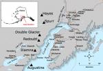
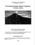
Augustine

MarkerMarkerMarker
2
MarkerMarkerMarkerMarkerMarkerMarkerMarkerMarkerMarkerMarkerMarkerMarkerMarkerMarkerMarkerMarkerMarkerMarkerMarkerMarkerMarkerMarkerMarkerMarkerMarkerMarkerMarkerMarkerMarkerMarkerMarkerMarkerMarkerMarkerMarkerMarkerMarkerMarkerMarkerMarkerMarkerMarkerMarkerMarkerMarkerMarkerMarkerMarkerMarkerMarkerMarkerMarkerMarkerMarkerMarkerMarkerMarkerMarkerMarkerMarkerMarkerMarkerMarkerMarkerMarkerMarkerMarkerMarkerMarkerMarkerMarkerMarkerMarkerMarkerMarkerMarkerMarkerMarkerMarkerMarkerMarkerMarkerMarkerMarkerMarkerMarkerMarkerMarkerMarkerMarkerMarkerMarkerMarkerMarkerMarkerMarkerMarkerMarkerMarkerMarkerMarkerMarkerMarkerMarkerMarker
7
MarkerMarkerMarkerMarkerMarkerMarkerMarkerMarkerMarkerMarkerMarkerMarkerMarkerMarkerMarkerMarkerMarkerMarkerMarkerMarkerMarkerMarkerMarkerMarkerMarkerMarkerMarkerMarkerMarkerMarkerMarkerMarkerMarkerMarkerMarkerMarkerMarkerMarkerMarkerMarkerMarkerMarkerMarkerMarkerMarkerMarkerMarkerMarkerMarkerMarkerMarkerMarkerMarkerMarkerMarkerMarkerMarkerMarkerMarkerMarkerMarkerMarkerMarkerMarkerMarkerMarkerMarkerMarkerMarkerMarkerMarkerMarkerMarkerMarkerMarkerMarkerMarkerMarkerMarkerMarkerMarkerMarkerMarkerMarkerMarkerMarkerMarkerMarkerMarkerMarkerMarkerMarkerMarkerMarkerMarkerMarkerMarkerMarkerMarkerMarkerMarkerMarkerMarkerMarker
Legend
Red (Warning)
Orange (Watch)
Yellow (Advisory)
Green (Normal)
Uninstrumented
Community
Webcam
Instrument
Earthquake Magnitude
0 7+
Earthquake Age
Last 2 Hours
Last 2 Days
Last 1 Week


Facts


  • Official Name: Augustine Volcano
  • Seismically Monitored: Yes
  • Color Code: GREEN
  • Alert Level: NORMAL
  • Elevation: 1260m (4133ft)
  • Latitude: 59.3626
  • Longitude: -153.435
  • Smithsonian VNum: 313010
  • Pronunciation:
  • Nearby Towns:
    • Pedro Bay 38 mi (60 km) NW
    • Pope-Vannoy Landing 39 mi (64 km) NW
    • Kokhanok 47 mi (75 km) NW
    • Nanwalek 53 mi (86 km) SE
    • Port Graham 57 mi (91 km) SE

    Distance from Anchorage: 176 mi (284 km)

Description

From Miller and others (1998) [1] : "Augustine Island, an 8 by 11 km island in lower Cook Inlet, is composed almost entirely of the deposits of Augustine Volcano. Jurassic and Cretaceous sedimentary strata form a bench on the south side of the island and are overlain by granitoid glacial erratics and volcanic hyaloclastites. The volcano consists of a central dome and lava flow complex, surrounded by pyroclastic debris. The irregular coastline of Augustine Island is due to the repeated catastrophic collapse of the summit dome, forming debris avalanches down the flanks and into Cook Inlet. At least 11 avalanches have occurred in the past 2000 years with an average recurrence interval of about 150-200 years [2] [3] .
"Augustine lies within the area of uplift resulting from the 1964 Alaska earthquake; 30-33 cm of uplift was measured on the northwest side of the island [4] . A 25-meter-high, south-facing submarine scarp 3 km south of the island, of similar orientation to joint sets in sedimentary rocks of the Kamishak River area (on the Alaska Peninsula), is almost certainly of tectonic origin."

Name Origin

The volcanic peak on Augustine Island was named "Mount San Augustine" in an 1867 U.S. Coast and Geodetic Survey report, and "Mount Chinabora" on a 1928 U.S. Post Route map. Captain James Cook named the island "Saint Augustine Island" in 1778 because it was sighted on St. Augustine's Day (Orth, 1971). In recent years, the "Saint" has been dropped from the name of both the island and the volcano; the volcano's formal name is "Augustine Volcano." Tebenkov (1852) called the island "O[strov] Chernoburoy", meaning "black brown" (Orth, 1971).


References Cited

[1] Catalog of the historically active volcanoes of Alaska, 1998

Miller, T. P., McGimsey, R. G., Richter, D. H., Riehle, J. R., Nye, C. J., Yount, M. E., and Dumoulin, J. A., 1998, Catalog of the historically active volcanoes of Alaska: U.S. Geological Survey Open-File Report 98-0582, 104 p.

[2] Cyclic formation of debris avalanches at Mount St Augustine volcano, 1992

Beget, J. E., and Kienle, J., 1992, Cyclic formation of debris avalanches at Mount St Augustine volcano: Nature, v. 356, n. 6371, p. 701-704.

[3] Preliminary volcano-hazard assessment for Iliamna Volcano, Alaska, 1999

Waythomas, C. F., and Miller, T. P., 1999, Preliminary volcano-hazard assessment for Iliamna Volcano, Alaska: U.S. Geological Survey Open-File Report 99-0373, 31 p., 1 sheet, scale unknown.
full-text PDF 2.84 MB

[4] Recent volcanic activity on Augustine Island, Alaska, 1968

Detterman, R. L., 1968, Recent volcanic activity on Augustine Island, Alaska: in Geological Survey research 1968, Chapter C, U.S. Geological Survey Professional Paper PP 0600-C, p. C126-C129.
full-text PDF 185 KB

Current Activity

No new updates for Augustine volcano since September 6, 2019, 10:29 am.

Webcams

Webicorder

Geodesy Sensors

Color Code Timeline

Reported Activity

Modern Eruptions

Augustine

Augustine Eruption Timeline

From Kisslinger (1983), translating Doroshin (1870): "It was active in 1812, as was positively confirmed for me by a native of the village located on the opposite shore of Kenai Bay. It wasn't possible to land canoes on the island while the wind was blowing, because the lava, which descends into the sea in a gentle slope, could at any time tear the skin of the canoe."
Waitt and Beget (2009) state "This sparse and cryptic information suggests pyroclastic flows carrying boulder-sized pumice swept down the north and northeast flanks and into the sea. Such flows could voluminously reach down the short and steep run to water before debris avalanche added land to the coast in 1883 [see plate 1 in original text].
"Yet we identify on Augustine Island no mappable deposit definitely of 1812. At the likely focus of pyroclastic flows, north and northeast, five later eruptions also focused debris - voluminously so in 1883, 1976, and 1986. The 1883 debris avalanche deeply buried that lower volcano flank in coarse rubble and established a new coast more than 2 km beyond the old one. There's no seeing what lies below these deposits. But in our interpretation of some measured sections [see plate 2 in original text] we speculate that a thin ash below the ash layer we identify with 1883 to be 1812 ash."

Augustine 1883/10

October 6, 1883 — 1884

Waitt and Beget (2009) summarize the 1883 eruption as follows: "1883 is the first Augustine eruption documented to some extent by contemporaneous written accounts: an unpublished logbook of the Alaska Commercial Company post situated atop the spit at English Bay, published summaries by Dall (1884), Davidson (1884), and Becker (1898), an unpublished letter and an unpublished mission report both of 1884, and field notes by J.E. Spurr in 1898.
"On the 6th of October 1883, Augustine Volcano -- or Chernoburoy (variously spelt) as the Russians knew it -- generated a tsunami and an ash plume experienced from English Bay 85 km away on the east mainland. The record book of the Alaska Commercial Company (1883) at Alexandrovsk (English Bay) records various routine data for 6 October 1883. Then this entry:
'At this Morning at 8.15 o'clock 4 Tidal Waves flowed with a westerly current, one following the other at a rate of 30 miles p. hour into the shore, the sea rising 20 feet above the usual Level. At the same time the air became black and foggy, and it began to thunder. With this at the same time it began to rain a finely Powdered Brimstone Ashes, which lasted for about 10 Minutes, and which covered all the parts of Land and everything to a depth of over 1/4 of a inch, clearing up at 9 o'clock A.M. Cause of occurrence: Eruption of the active Volcano at the Island of Chonoborough. Rain of Ashes commencing again at 11. o'clock A.M. and lasting all day.'
"And for 7 October:
'Volcano ejecting fire and heavy black Clouds of Smoke all day long.'
"The geographer William Dall (1884) rushed into print summary information derived from George Davidson (USCGS) and from a Capt. Sands and a Capt. Cullie (Alaska Commercial Company) observed from English Bay and then the sea:
'Smoke first arose from the peak in August. On the morning of Oct. 6 the inhabitants heard a heavy report, and saw smoke and flames issuing from the summit of the island. The sky became obscured, and a few hours later there was a shower of pumice-dust. About half-past eight o'clock the same day an earthquake wave, estimated at thirty feet height, rolled in upon the shore, deluging the houses on the lowland, and washing the boats and canoes from the beach. It was followed by others of less height. The ash fell to a depth of several inches, and darkness required lamps to be lighted. At night flames were seen issuing from the summit. After the first disturbances were over, it was found that the northern slope of the summit had fallen to the level of the . . . shore, and the mountain appeared as if split in two. . . . The cleft . . . crosses the island from east to west.'
"George Davidson, who for the USCGS mapped much of the Washington-Oregon-California coast in 1850-53 and the Alaska coast in 1867-69, was experienced with coastal ship captains and eyewitness reporting. Having been partly scooped of his own story by Dall, Davidson (1884) gives a more detailed account of Augustine's effects partly derived from 'settlers and fishing-parties' at English Bay:
'About eight o'clock on the morning of Oct. 6, 1883, the weather being beautifully clear, the wind light from the south-westward, and the tide at dead low water, the settlers and fishing-parties at English Harbor heard a heavy report to windward (Augustin bearing south-west by west three-fourths west by compass). So clear was the atmosphere that the opposite of north-western coast of the inlet was in clear view at a distance of more than 60 miles.
'When the heavy explosion was heard, vast and dense volumes of smoke were seen rolling out of the summit of St. Augustin, and moving to the north-eastward; and at the same time (according to a hunting-party in Kamishak Bay), a column of white vapor arose from the sea near the island, slowly ascending, and blending with the clouds. The sea was also greatly agitated and boiling, making it impossible for boats to land upon or to leave the island.
'From English Harbor . . . it was noticed that columns of smoke, as they gradually rose, spread over the visible heavens, and obscured the sky, doubtless under the influence of a higher current (probably north or northeast). Fine pumice-dust soon began to fall, but gently, some of it very fine, some very soft, without grit.
'At about twenty-five minutes past eight A.M., or twenty-five minutes after the great eruption, a great 'earthquake wave,' estimated as from twenty-five to thirty feet high, came upon Port Graham [English Bay] like a wall of water. It carried off all the fishing-boats from the point, and deluged the houses. This was followed, at intervals of about five minutes, by two other large waves, estimated at eighteen and fifteen feet; and during the day several large and irregular waves came into the harbor. The first wave took all the boats into the harbor, the receding wave swept them back again to the inlet, and they were finally stranded. Fortunately it was low water, or all of the people at the settlement must inevitably have been lost. The tides rise and fall about fourteen feet.
'These earthquake waves were felt at Kadiak [Kodiak], where they are doubtless on the register of the coast-survey tide-gauge at that place.'
"An indirect but independent record of the sea waves striking the Kenai Peninsula mainland exists in a report of the Russian Orthodox priest heading the Kenai mission, Heiromonk Nikita, who after a visit of his southern parishes wrote on 28 May 1884:
'Influenza Kenai, Ninilchik, Seldovia, Alexandrovsky [English Bay], nearly all children up to 2 years of age were swept away. At the same time this region suffered from innundation caused by the eruption of Chernabura volcano, which is about 60 miles across the straight from Alexandrovsky. The innundation so frightened natives of Alexandrovsky that they moved their huts to higher ground in one night [Russian Orthodox church records, Diocese of Alaska, Library of Congress, microfilm copy of Reel 1, Box 400, University of Alaska Anchorage Archives].'
"This report is consistent with Davidson's and Dall's that the largest sea wave was high enough to 'deluge the houses' at English Bay.
"The volcano evidently continued in eruption at least intermittently for weeks or months. Some time after 10 November 1883 (when in schooner Kodiak Captains Cullie and Sands approached Augustine Island), Davidson (1884) includes in his account:
'The condition of the Island of Augustin or Chenaboura, according to the latest accounts, is this: --
'At night, from a distance of fifty or sixty miles, flames can be seen issuing from the summit of the volcano; and in the day-time vast volumes of smoke roll from it.'
"Another entry in the Kenai Mission record by Heiromonk Nikita on 27 May 1885 reads:
'Earthquakes still quite frequent here [at Kenai?] and Chernabura is still smoking.'
"Davidson's (1884) account includes several obvious errors of observation or interpretation, including a Capt. Cullie description rendered into a fanciful figure (Davidson, 1884, p. 188). A chagrined Davidson later tried to rectify this in a letter (unpublished) dated 5 November 1884 addressed to Prof. J.E. Hilgard, Superintendent of the USCGS. One of Davidson's late-1883 sources, Capt. Cullie of the Alaska Commercial Company at English Bay, had sailed past Augustine Island in June 1884. As reported in Davidson's November letter, Capt. Cullie saw from the north that:
'. . . from the summit a great slide of the mountain over half a mile broad had taken place towards the rocky boat harbor on the northnorthwestward.11 It appeared as if there had been a great sinking of the rocks under the summit leaving a face of wall overlooking the slide. Down this had poured the lava [sic] and erupted material to the base of the mountain and had pushed into the boat harbor and filled it up. In the upper part of lava [sic] outflow was issuing great volumes of white smoke . . .'
"A later record about Augustine's preeruption 'boat harbor' exists in the field notes of USGS geologist J.A. Spurr (USGS archives):
'Oct. 17 (1898) Trader says here at Katmai that eighteen years ago [sic] three families from Kodiak went with families and baidarkas to St. Augustine Island to spend the winter. Built barabaras on the shore of a bay. The mountain began to shake continually and finally they took their families off, while they stayed on themselves. Finally the mountain began to shake so violently that they put all their effects in their bairdarkas and started on a stormy day. Scarcely were they at the mouth of the bay when an explosion occurred, ashes, boulders, and pumice began pouring down and the barabaras were buried and the bay filled up with debris. At the same time there were many tidal waves, so the natives nearly perished with fright, yet finally escaped.'
"Becker's (1898) published account mostly reiterates information in Davidson (1884) and Dall (1884) about events of 6-7 October 1883 but includes a few details from a climb in 1895 by Becker and his assistant Purington nearly to the summit and to the new dome (Becker, 1898, p. 29):
'. . . Steam escaped from countless crevices, most of them on the inner cone [that is, a new dome] . . . . Masses were from time to time detached, rolling down to the bottom of the deep moat which separates the outer crater from the inner cone . . . . The inner cone [is] nearly as high as the outer rim.'"
Waitt and Beget (2009) describe the Burr Point debris-avalanche deposit that formed during this eruption, evidence for a tsunami, the 1883 pyroclastic flow and surge deposits, and the 1883 lava dome in detail.
Simkin and others (1995) also calculate the volume of the lava flow plus the volume of the lava dome to be 0.13 cubic km. Simkin and Siebert (2002- ) give an estimate of 0.13 +/- 0.04 cubic km for lava from this eruption, and 0.51 +/- 0.5 cubic km as a tephra volume.

Loading

According to Kienle and Forbes (1977) a mission report on May 27, 1885 stated: "earthquakes still quite frequent here (Kenai?) and Chernabura is still smoking." Becker (1898) says the volcano was steaming from shore to summit.
Waitt and Beget (2009) believe that this account describes rain or snowmelt infiltrating still-hot 1883 pyroclastic-flow deposits.

From Cordeiro (1910): "The island of Chernobura is reported as smoking." Cordeiro does not specify when this "smoking" occurred, but says that most of his observations stem from his 1892 and 1894 cruises in Alaska.
Waitt and Beget (2009) believe this smoke was a lingering effect of the still-hot 1883 dome within the summit crater.

From Russell (1910): "A slender cloud of steam ascended from the summit of the volcano, which seems to have been built up by eruptions of lapilli and dust since the explosion that rent it asunder."
Waitt and Beget (2009) believe this smoke was a lingering effect of the still-hot 1883 dome.

From The Alaskan (1902): "While Redoubt has been most active as regards recent volcanic eruption in Alaska, two other peaks in the Cook Inlet section have been thoring [sic] off smoke and steam in greater or less volume for several months. They are Mount Iliamna and Mount Augustine."
From Johnston and Detterman (1979): "Coats quoted Sapper (1917), who told nothing more about the activity or about his source of information * * * Detterman (1973), who mapped the volcano after its 1963-64 eruption, referred to unpublished field notes of T.W. Stanton of the USGS, who visited the island July 17, 1904. Those notes may have been the original source for Sapper's statement.
"The only reference to activity in 1902 in Stanton's notes is contained in this brief passage: It is reported that * * * in 1902 there was a large 'mud flow' when one side of the crater broke off and slipped down, according to A. Brown who says he witnessed it from the mainland."
Johnston and Detterman (1979) state that there was no eruption in 1902, based on 1) their inability to find a primary reference to activity at Augustine, 2) photographs taken in 1895 and 1904 seem to show no change to the summit crater, 3) ash layers are found in Skilak Lake for every historic Augustine eruption except the 1902, and 4) they found no 1902 ash layer on Augustine Island. A primary eruption reference (The Alaskan newspaper) has now been located - which suggests that perhaps a minor eruption, too small to modify the summit crater or deposit long-lasting ash layers, did occur. It is also possible that there was no eruption, and Augustine was merely experiencing an increase in fumarolic activity.

Augustine 1908/3

March 10, 1908

From the Seward Daily Gateway (1908): "On the night of the 10th inst. as Captain Z. Moore of the steamer Dora was making his return trip from Unalaska to Seward, he saw in the distance what seemed to be fireworks on a very extensive scale. Immediately taking his bearings the captain found he was 63 miles off Chonobora island and the flames which lighted the heavens above came from the previously long extinct volcano St. Augustine. As the molten mass within the mountain was thrown up by internal forces on the earth, the outer crust was parted and the red glow of the melted mass cast its lights far upward on the smoke and clouds above. This was followed by intervals of darkness caused by the subsidence of the volcanic action. Then again the heaven above would glow with the reflection of the light from earth's mighty furnace making as fine a display of nature's fireworks as has ever been seen in this part of the world."
Waitt and Beget (2009) describe this as "a minor burst of molten lava."

Augustine 1935/3

March 13, 1935 — August 18, 1935

The Anchorage Daily Times published at least two articles in 1935 concerning an eruption at Augustine. The first, published April 3, states: "Augustine Island * * * is a roaring volcano, hurling a mighty volume of smoke into the heavens, pounding thousands of tons of lava down the sides into the sea and hurling dust over the areas for a radius of seventy miles.
"News to this effect was brough yesterday by Pilot Roy Dickson of the Star Air Service, returning here from that vicinity, after flying over and around the roaring inferno, accompanied by George L. Johnson of this city. Mr. Johnson took a moving picture of the volcano in action.
"Dickson and Johnson describe Augustine as one of the most awe-inspiring and magnificent sights they ever witnessed. Huge clouds of vapor are rising from the high cone, oozing from a main rupture in the center of the peak, and from cracks at various places about the top. The cone has an altitude of 3900 feet above the sea.
"The Augustine rises cone shaped sheer from the waters of the sea * * * having only a narrow border of land about the bottom, where for a long time wild strawberries have thrived. Now they are buried under the flood of lava and deposit of ash, and the material pouring down the steep sides pours into the sea at many places. Huge pieces of black material, lava or other light substance from the cone float on the waters.
"The smoke seems to be blowing chiefly toward Bristol Bay. Dickson and Johnson visited the voclano several days ago, flew over and around it several times, and attempted to return, but cloudy weather prevented the return. They flew there from Iliamna."
On July 13, The Anchorage Daily Times reported: "Contours of the famous Augustine volcano near Kamishak Bay have changed since it started erupting this summer, William Berry, fishing warden, said last night.
"Mr. Berry said the eruptions have blown off sections of the cone so that it no longer is of perfect symmetry. He told of lying off the island several days in his boat and watching the volcano. The lava spurts into the air continually and rolls down the side of the mountain. At night it looms up red from the molten rock. Steam and smoke blows out of the cone, he said. Mr. Berry brought some excellent snapshots of the volcano in action."
From Kienle and Swanson (1985): "Detterman (1963) reports that the eruption started on March 13 and ended August 18. In mid-August a tall black eruption cloud, 10 to 30,000 feet (3 to 9 km) high, rather thin and not billowing out at the top was seen by Mr. Wahleen (personal communication) from aboard the S.S. Dellwood just after leaving False Pass on a great circle route to Seattle. Since no other eastern Aleutian volcano was active that year, it seems that Mr. Wahleen saw the final major eruption of Augustine Volcano on August 19, from a distance of about 800 km. Between March and August, minor and major eruptions were also observed from the west side of Cook Inlet. Considerable amounts of tephra were erupted, and pyroclastic flows and mudflows were concentrated on the northeastern and southwestern flanks of the volcano (Detterman, 1963). The 1883 dome described by Becker (1895) was presumably destroyed during the initial vent clearing eruption * * * Finally, two new lava domes were emplaced in the summit crater."
Waitt and Beget (2009) additionally confirm the existence of the 1935 lava dome: "Remnant of a 1935 dome of gray porphyritic andesite forms a prominent point on the north-northwest of the summit dome complex [unit 35d, plate 1; fig. 16 in original text] and a broad dome lobe that descends the west-southwest summit cone. The 1935 dome is identified by several sources: (1) contemporaneous shipboard photographs taken by Kenai Peninsula resident Steve Zawistowski in July 1935 showing the steaming west-southwest lobe [fig. 46 in original text]; (2) USGS oblique aerial photographs taken in 1944 by John Reed, in 1959 by Bruce L. Reed, and in 1960 by Austin Post -- all before large changes to the summit area during the 1963-64 and 1976 eruptions; and (3) Detterman (1968, 1973), who in 1967 in the field distinguished the then-new 1963-64 dome from remnants of older domes. The 1944, 1959, and 1960 photographs actually show two domes: one (1883) inside the 1883 crater, the other (1935) on and outside the west rim [see fig. 45 in original text]."
Waitt and Beget (2009) also confirm the flank deposits: "High on the southwest flank downslope of the 1935 dome heads a fan of rubble whose angular andesite dome-rock boulders are as large as 6 m [see unit 35b, plate 1 in original text]. This material is similar to coarse lithic pyroclastic-flow deposits on the south flank of the 1963-64 eruption. Because the southwest fan lies directly downslope from the 1935 dome, we interpret it to have been emplaced then.
"Zawistowski’s July 1935 photographs from a boat off the southwest coast show light-colored fresh deposits in west-southwest swale, clearly recently shed downslope from a steaming, active dome [see fig. 46 in original text]. Some of the pyroclastic-flow deposits in this broad swale that we map with the 1964 eruption may include indistinguishable similar coarse debris from 1935."

Barrett (1978) notes that in 1944 a small lava dome was discovered forming in the crater.

Loading

Augustine 1963/10

October 11, 1963 — August 19, 1964

From Kienle and Swanson (1985): "On October 11, 1963, Augustine burst into activity again, sending an ash column to about 3,000 m and a pyroclastic flow down the flank of the volcano, which set fire to brush on the lower slopes. According to Detterman (1968), the eruption continued intermittently for about 10 months, with major explosions recorded on November 17, 1963, July 5 and August 19, 1964. Presumably, during one or more of the earlier vent clearing eruptions in late 1963 ash was dispersed in a northeasterly direction and preserved in the varved sediments of Skilak Lake, 210 km distant (Rymer and Sims, 1976).
"According to reports from field parties of the Pan American Petroleum Corporation (D.H. Reno, communication to R.B. Forbes) there was no unusual precursor activity during the summer 1963 field season, which terminated mid-July, but in the June-July 1964 field season the volcano was reported to be quite active and considerable ash was encountered on the mountains on the mainland up to 15 km west of Augustine. Where the ash was not disturbed it was a maximum of about 2.5 cm deep.
"Detterman (1968) reports that the cone emitted smoke and steam all through 1965 and 1966, before he actually visited the island to map the deposits of the 1963/64 eruption in 1967. Detterman thought that the initial eruption was a nuee ardente eruption directed toward the southeast and originating at the base of the 1935 summit tholoid. It allegedly blew out a section of crater wall '3,200 feet long, 500 feet high and 700 feet thick'.
"The 1963/64 eruptions greatly altered the summit configuration and finally a new dome emerged in the new crater southeast of the remnant of the 1935 summit tholoid. By September 1964 it had completely filled the crater, engulfed what was left of the eastern and southern crater rim and stood much higher than the original 1935 summit."
Detterman (1968) estimates the volume of debris flow at 0.09 cubic km, an estimate considered high by Kienle and Swanson (1985). Newhall and Melson (1983) list a "new dome" volume of 0.066 cubic km.

Augustine 1971/9

September 2, 1971 — October 7, 1971

From Kienle and Swanson (1985): "A photograph taken during the [earthquake] swarm by Austin Post of the U.S. Geological survey on September 3 shows a strong plume fed by very active fumaroles on the 1964 lava dome. A small ash eruption and incandescence (red glow) on the flank of the volcano was seen during the late evening twilight of October 7 from a fishing boat 38 km north of the volcano. The eruption is corroborated by seismic tremor, which was recorded on both of the then existing seismic stations between 23 and 01 hours on October 7/8."
Waitt and Beget also describe this event: "In September-October 1971 billowing fumaroles and a report of incandescence followed an earthquake swarm within the volcanic cone in late August and early September (Kienle and Swanson, 1980, 1985, p. 25-28)."

Augustine 1976/1

January 22, 1976 — April 24, 1976

From Shackelford (1978): "In the morning of 22 January Augustine began a period of major activity from a new vent located at the contact of the 1935 and 1964 domes. The first major eruption began at 0740 AST on 23 January. On that date there were at least 8 major eruptions, one was at 1618 AST. An additional 4 major explosive outbreaks took place on 24-25 January. The eruption clouds pierced the tropopause, reaching heights + 10,000 m to 14,000 m a.s.l. Ash falls took place at Iliamna, Homer, Seldovia, and Anchorage (1.5mm). The January eruptions explosively removed most of the summit 1964 dome, forming a crater breached to the N.
"* * * The explosive activity was accompanied by major pyroclastic flows, and mudflows and lahars. The January glowing avalanches spread radially over the island, reaching the sea on the S, NE, and NW flanks. The Burr Point Research Station (NW tip of island) was severely damaged by one or more avalanches, although protected by a ridge, as a result of a back eddy in the clouds. Several days afterwards, temperatures in the pyroclastic flow deposit exceeded 400 degrees C at a depth of 2.7 (deposit is on the NE slope). There was an active fumarole field at the distal end of the deposit. Augustine was relatively quiet from 26 January to 5 February.
"The second cycle of eruptions began with the renewal of major activity at 0443 on 6 February, resulting in falls of ash and mud along the Kenai Peninsula. A strong eruption at 1230 on the 6th produced a cloud that rose to a height of 8-9 km. A blizzard-like ash fall at Homer on the 6th was the heaviest of the entire eruption, prohibiting vehicular traffic because of the induced darkness at 1800. Eruptions generally ended on the 15th, producing eruption plumes that usually rose to heights of 3-4, 5 km. Again, there was production of major pyroclastic flows which followed the same paths as those of January. The January flows had formed a new beach on the NE part of the island, and a further extension of this beach resulted from the glowing avalanches of February * * * Activity on the 16th consisted of occasional steam explosions. On the 18th there were a few ash-laden puffs rising from Augustine. Observations on that date showed that a new tholoid had formed in the new crater, probably on the 12th and 13th which was a period of continuous harmonic tremor. The new dome was found to be about 260 m above its base. From 19 February to April another quiet period ensued, although there were some block and ash flows off of the new dome beginning in late February. There was some earthquake swarm activity on 15 to 25 March.
"The third and last cycle took place in April. In the early part of the month explosion earthquakes began to be recorded on the new seismic array. The number of eruptions as follows: 6-12 eruptions per day during 6-9 April, 1 eruption per hour on 10-11 April, almost continuous intense eruptions during 12-18 April, 12 eruptions per day on 18-22 April. Eruptive behavior returned to low levels on the 23rd. Since 24 April there have been no further eruptions, just quiet degassing from the new dome, with some spectacular plumes reported. The April explosive activity was accompanied by block and ash flows shed off the new dome, which underwent a period of renewed growth in April."
David Johnston (1978) calculates that "roughly 0.17 cubic km of rock was erupted in 1976, of which about 27% was erupted in January, 59% in February, and 14% in April. Fifty-three percent of the volume is in pyroclastic flow deposits, 38% in the lava dome, and 8% in ash-fall and pyroclastic surge deposits. Ejecta erupted in January include approximately 10% andesite scoria, 50% dacite pumice, and 40% hybrid and banded pumices."
Kienle and Swanson (1985) have slightly different volume estimates for this eruption: "* * * the estimated bulk volume of the ejecta from the 1976 eruption is about 0.4 cubic km, of which 0.06 cubic km are flows on the island itself and the rest [0.339 cubic km] is tephra. We arrived at this estimate by digitizing the the pre- and post-eruption topography of the sector most affected by debris flow activity, the northeast sector of the Island (see Figure 31 in original text) and by using conservative estimates of the total thickness of tephra accumulation for the area that was affected by ash falls (See Figure 15 in original text)."

Loading

Augustine 1986/3

March 27, 1986 — September 10, 1986

From Swanson and Kienle (1988): "Precursory seismic activity was first detected in July 1985, 8 months prior to the 1986 eruption. A sharp increase in seismicity in March 1986 led to speculation about a possible eruption (Kienle, 1986). A several-order-of-magnitude increase in seismic event counts on the morning of March 26 heralded the eruption that began on the morning of March 27. A short-term forecast of the eruption was made on the afternoon of March 26 (Kienle and others, 1986).
"The initial phase of the eruption involved explosive removal of a portion of the 1976 dome and formed a small (about 100 m in diameter) vent on the southwest flank of the dome (Miller and others, 1987; Yount and Miller, 1987). Numerous pyroclastic flows were observed during the 103 hours of this first eruptive phase, and eruption columns reached heights in excess of 12,000 m (Yount and others, 1987). Pyroclastic flows were directed through the breach in the north side of the crater and spread out on the lower flanks of the volcano. Some of these pyroclastic flows reached the sea to the west and east of Burr Point, and ash cloud surges continued for some distance offshore.
"Prevailing winds on March 27 and 28 were from the southwest and spread ash throughout Cook Inlet. Later on March 28, the winds shifted to the west and finally to the north on March 30 and 31. Ash was thus scattered over populated areas in Cook Inlet only during the early stages of the eruption, but the dust lingered in the air over Cook Inlet, including Anchorage, until March 31.
"Lava was extruded during the second eruptive phase from April 23 to 28. A short blocky lava flow issued from the base of the 1976 dome remnant. Pyroclastic flows descended from the growing dome, but none of them reached the sea.
"* * * A period of accelerated dome growth between August 30 and 31, 1986, resulted in an increase of pyroclastic flow activity. Flows moved down the north flank of the volcano for distances up to 2.2 km from the source (Kienle, 1986). Eruption clouds rose 1000 to 2000 m above the volcano during this episode. None of the pyroclastic flows reached the sea.
"High-silica, two-pyroxene andesite, similar to that produced in previous Mount St. Augustine eruptions was also erupted in 1986 (Swanson and others, 1986; Harris and others, 1987). Groundmass glass in the 1986 andesites is rhyolitic in composition, as in past eruptions, and this is one factor in the explosive character of the eruption. Distribution of eruptive products and volumes of material erupted in 1986 was also similar to other historic eruptions.
"Pyroclastic flow deposits were restricted to the north flank of the volcano, the result of funneling through the breach in the north side of the crater. Lahars composed of reworked air fall deposits form a circular pattern around the upper part of the cone. On the south flank, lahars descended to about 300 m above sea level.
"The new dome occupies the central part of the volcano and a small lava flow extends just a few hundred meters from the dome. A new 50-m-high spine was extruded during the August phase of renewed dome growth. Since then, a large section of the 1986 dome has collapsed and has formed a debris avalanche deposit on the upper northern slope of the volcano.
"Incandescent vents were discovered on August 28, 1987, at the southern base of the spine, with maximum fumarole temperature of 88 degrees C (R. Symonds, personal communication, 1987).
"A new topographic map of Augustine Island was prepared by North Pacific Aerial Surveys for the U.S. Geological Survey from aerial photography taken on September 9, 1986, using geodetic control points surveyed by University of Alaska and U.S. Geological Survey personnel on June 6, 1986 (J. Power, personal communication, 1986). The map shows that the 1986 dome had reached a height of 1252 m by September 9, 1986. Thus the dome gained about 26 m in elevation between 1976 and 1986. The highest point of the volcano is the south peak, which remained unchanged at 1252 m. More changes in dome height could have occurred since then, but the dome has not yet been resurveyed. The total expanded volume of the 1986 pyroclastic flow deposits on Augustine Island is estimated to be close to the 1976 pyroclastic flow volume of about 0.05 cubic km, but could be a little larger."
The April edition of the Scientific Event Alert Network Bulletin (v. 11, n. 04) gives an inflated material estimate of 0.11 cubic km for the March 31 pyroclastic flow, and an estimate volume for the dome (as of May 6) of 0.06 cubic km.

Loading

From Smithsonian Institution (1988): "Increased steam emission follows earthquake. At 1405 on 30 July, MarkAir pilots Kriss Paul and Bruce Gorham observed larger than normal steam emission from Augustine. When first observed, the plume was described as dirty steam with dark streaks at 1600 to 1800 m altitude, but it rose to about 2,700-3,000 m altitude within several minutes. At 1530, on their return from Kodiak to Anchorage, the pilots observed the plume spreading E and topping out slightly higher than 3600 m altitude. The volcano has emitted steam continuously since its 1986 eruption. Less than 4 minutes before the plume was first observed, an earthquake with an epicenter of 60.0°N, 153.5°W (about 75 km NW of the volcano) was felt in the lower Cook inlet region. The event occurred at 1401:29 and was located by the Alaska Tsunami Warning Center at a depth of 169 km with a local magnitude of 4.1. The University of Alaska Geophysical Institute seismic network detected two Augustine earthquakes at about 1603 and 1621 with above-normal magnitudes (about 1)."

McGimsey and others (2003) consider the 1998 activity non-eruptive : "On July 12, 1998, charter pilots from Homer who routinely fly by Augustine noted fingers of mud up to about 250 ft wide (76 m) extending down from the cloud-enshrouded summit to snowfields on the upper north-northeastern flank. Other snowfields near the summit were discolored by fine gray ash deposits. One particular flow of pinkish muddy material had reached the sea. AVO received this information on July 13 and immediately canvassed the seismic, tiltmeter, and temperature sensor data for the previous several days. Rockfall and small avalanches are a common, if not everyday, occurrence on Augustine and have recognizable seismic signatures. The seismic records for July 10 showed a larger than usual avalanche event at 21:23 ADT that lasted at least 30 seconds. On July 14, the same charter pilots flew by Augustine - this time during clear weather - they reported that a portion of the spine that was extruded from the summit dome in 1986 (see figure 5 in original text) had collapsed and was the apparent source of the small mudflows observed several days earlier. They also reported that the volcano seemed to be steaming more than usual. AVO geophysicist John Power measured fumarole temperatures near the base of the toppled spine later in July and reported temperatures of 93.8 and 96.9oC, similar to those measured in 1997."

Augustine 2003/9

September 9, 2003

From McGimsey and others (2005): "AVO received a pilot report through Kenai Flight Service of increased steaming at Augustine
volcano about mid-day on September 9, 2003. Concomitant to this report we received an inquiry about Augustine from the Homer Police Department. A check of the seismograms and spectrograms revealed nothing unusual."

Augustine 2005/12

December 2005 — March 31, 2006

From Power and others (2006): The 2006 eruption of Augustine consisted of four phases defined by the character of unrest or eruptive activity, which are described below. These phases are the precursory (May 2005 to 11 January 2006), the explosive (11 to 28 January), the continuous (28 January to 2 February), and the effusive (2 February to late March).
"The precursory phase began as a steady increase in microearthquakes beneath the volcano, ranging from one to two per day in May 2005 to 15 per day in mid-December [see Figure 3 in original text]. In July 2005, geodetic baselines began to lengthen, indicative of pressurization at sea level centered beneath the edifice (Cervelli and others, 2006). On 2 December 2005, seismometers began recording signals from small phreatic explosions; the largest signals occurred on 10, 12, and 15 December. An overflight on 12 December revealed vigorous steaming, a new vent on the summit's southeastern side, and a dusting of ash on the volcano's southern flanks. The ash was a mix of weathered and glassy particles; the latter appear to be remobilized 1986 tephra. An explosion on 15 December disabled the telemetery for the two highest seismic stations [see figure 2 in original text].
"Augustine then entered an explosive phase, which lasted from 11-28 January 2006. A strong swarm of volcano-tectonic (VT) earthquakes began at 0030 UTC on 11 January, culminating in explosive eruptions at 1344 and 1412 UTC. These explosions produced ash plumes, reported by the U.S. National Weather Service (NWS) to have reached heights greater than nine kilometers above sea level (asl), which moved slowly to the north and northeast. Ash sampled on 12 January was primarily dense or weathered fragments, suggesting little juvenile magma. Over the next 36 hours, several sequences of small, regularly spaced VT earthquakes, many with identical waveforms, occurred at rates as high as three to four per minute. Similar earthquakes, referred to as clones or drumbeats, have been associated at other volcanoes with the emplacement of lava domes (Dzurisin and others, 2005).
"Monitoring instruments also recorded six powerful explosions that occurred between 1324 UTC on 13 January and 0914 UTC on 14 January [see figure 3 in original text]. The first explosion destroyed the seismometer and CGPS high on the volcano's northeastern flank [see figure 2 in original text]. Plumes reached altitudes of 14 kilometers asl and deposited traces of ash on southern Kenai Peninsula communities. Ash from these eruptions was more heterogeneous and contained dense particles as well as fresh glass shards, indicating the eruption of new magma. Satellite imagery tracked these plumes as they moved eastward and disrupted commercial airline traffic to and from Alaska.
"A 16 January overflight revealed a small, new lava dome at the summit. An explosive eruption at 1658 UTC on 17 January sent ash to 13 kilometers asl that moved westward. The eruption left a 20- to 30-meter-diameter crater in the new dome and produced ballistic fields on the volcano's western flanks. Data transmission from the west flank CGPS station stopped coincident with this explosion [see figure 2 in original text]. Additionally, the eruptions of 13-17 January generated pumiceous pyroclastic flows, snow avalanches, and lahars that moved down the volcano's flanks [see figure 2 in original text].
"The volcano then entered a period of more continuous eruptive activity that began at 0534 UTC on 28 January and that lasted until 2 February. The phase began with four explosive eruptions that generated ash plumes to heights of nine kilometers asl [ see figure 3 in original text]. Ash moved southward and fell in trace amounts on Kodiak Island. These explosions generated substantial pumiceous pyroclastic, block, and ash flows that destroyed seismic and CGPS stations on the west and north flanks of the volcano [see figure 2 on original text]. Destruction of these seismometers compromised AVO's ability to assign reliable hypocentral depths to earthquakes.
"Data from the remaining CGPS stations indicated that the volcano reversed its long inflationary trend (during which accumulating magma caused a swelling of the volcano's surface) and began a sharp deflation that continued until 10 February [see figure 3 in original text]. Modeling suggests the locus of deflation, which results from the removal of magma, was much deeper (~10 kilometers) than the precursory signal. On 29 January, the seismic network began to detect numerous block and ash flows - generated by small failures of the growing lava dome - cascading down the volcanos northern flanks [see figure 2 in original text].
"Augustine then entered an effusive phase, which lasted through late March. From 2 February through 6 March, block and ash flow signals continued to dominate the seismic record. Geodetic data showed inflation from 10 February until 1 March, when the volcano again reversed and entered an 11-day period of deflation [see figure 3 in original text]. On 7 March, seismic activity again shifted to small, mostly identical repetitious earthquakes. These events increased in rate and size, forming a continuous signal early on 8 March that lasted until 14 March. They then began a slow decline and disappeared by 16 March. Lava extrusion at the summit increased markedly in association with these repetitive earthquakes, and two blocky lava flows moved down the north and northeastern flanks [see figures 1 and 2 in original text]. Observations indicate that the effusion of lava stopped in late March. The volcano entered a final period of inflation between 12 and 31 March. The estimated volume of effusively erupted material is currently 30 million cubic meters."

McGimsey and others (2011) report that throughout 2007, continued cooling from the 2005-2006 eruption, steam plumes, and anomalous seismicity were observed at Augustine.

Loading

From Dixon and others, 2017: "Minor unrest occurred at Augustine Volcano in 2015 in the form of visible vapor plumes and rockfalls. In collaboration with Cascade Volcano Observatory (CVO), in June AVO installed a Multiple component Gas Analyzer System (MultiGAS) instrument at the summit of Augustine, designed to measure carbon dioxide (CO2), sulfur dioxide (SO2), and hydrogen sulfide (H2S). The Aviation Color Code/Volcano Alert Level remained GREEN/NORMAL throughout the year.
"Augustine has active fumaroles that often are visible under favorable atmospheric conditions. A gas measuring/sampling flight on April 3 detected low levels of water (H2O), CO2, SO2, and H2S, indicating that Augustine continues to degas at a low rate. The typical vapor plume at Augustine was often visible in web camera images during 2015, and was noted in satellite daily checks on January 25 and July 9. AVO received a PIREP of steam at Augustine on July 9.
"Twenty-two instances of rockfalls occurred at Augustine in 2015 as identified by emergent signals recorded on Augustine seismograph stations: this was twice the number of rockfalls reported in 2014. These rockfalls were concentrated during the months of June, July, August, and October. Rockfall signals at Augustine typically have an emergent onset and appear first at summit stations AUP and AUSS (fig. 5 [original text]).
"On June 12 and 13, AVO and CVO scientists installed a new, permanent MultiGAS/ seismograph station near the summit of Augustine. The MultiGAS instrument (fig.6) was designed and built at CVO, and includes sensors to intermittently measure CO2 and H2S. Data from these sensors are transmitted to AVO in near real time. A broadband seismograph station was installed near the MultiGas station at this time. Two months later another broadband seismograph station was added to the Augustine seismograph network."

Loading

From Cameron and others, 2020: "Minor unrest occurred at Augustine Volcano in 2016 in the form of a seismic swarm that began in February and continued intermittently into 2017. This swarm was similar to precursory seismicity observed at Augustine Volcano before previous eruptions, prompting increased surveillance on the Augustine data streams. The unrest did not result in eruption, and the Aviation Color Code and Volcano Alert Level remained GREEN and NORMAL, respectively, throughout the year.
"In 2016, there was a fivefold increase in the number of located earthquakes, totaling 836 for the year. The earthquakes were all located under the summit at shallow depths, 0–3 km (1–2 mi). Following a period of relative quiescence after the 2005–06 eruption, seismicity at Augustine Volcano increased slightly in 2012 when AVO located 54 earthquakes (fig. 8; Herrick and others, 2014). This activity continued to increase in 2013, 2014, and 2015 with 101, 127, and 162 earthquakes, respectively. The Augustine Volcano 2016 earthquake swarm began in February and continued at a high rate through the summer. A decrease in seismicity occurred during the fall and winter. Although the seismic activity looked much like precursory seismicity observed prior to the 1976, 1986, and 2005–06 eruptions, no eruption has yet ensued. No deformation or anomalous gas levels were noted in 2016.
"On January 24, the magnitude 7.1 Iniskin earthquake occurred at 10:30 UTC (1:30 AM AKST), between Augustine and Iliamna Volcanoes, and was the result of tectonic plate motions. This earthquake’s epicenter was about 27 km (17 mi) north of Augustine Volcano and 50 km (31 mi) south of Iliamna Volcano, at a depth of 122 km (76 mi). AVO did not detect any changes at either Augustine or Iliamna Volcano related to the earthquake."
Anomalous seismicity continued in 2017. From Dixon and others (2020): "The number of earthquakes located at Augustine Volcano in 2017 was abnormally high but was less than half (367) the number located in the previous year (836). The high level of seismicity was monitored closely and was determined not indicative of a pending eruption. A gas overflight in April was unable to make measurements of the plume, but on-ground measurements in July indicated that degassing activity remained at low levels. The Aviation Color Code and Volcano Alert Level at Augustine Volcano remained at GREEN and NORMAL, respectively, throughout the year."

Augustine 1812

Augustine 1883/10

Augustine 1885

Augustine 1893

Augustine 1895

Augustine 1902

Augustine 1908/3

Augustine 1935/3

Augustine 1944

Augustine 1963/10

Augustine 1971/9

Augustine 1976/1

Augustine 1986/3

Augustine 1988

Augustine 1998/7

Augustine 2003/9

Augustine 2005/12

Augustine 2015

Augustine unrest 2016

1300
1310
1320
1330
1340
1350
1360
1370
1380
1390
1400
1410
1420
1430
1440
1450
1460
1470
1480
1490
1500
1510
1520
1530
1540
1550
1560
1570
1580
1590
1600
1610
1620
1630
1640
1650
1660
1670
1680
1690
1700
1710
1720
1730
1740
1750
1760
1770
1780
1790
1800
1810
1820
1830
1840
1850
1860
1870
1880
1890
1900
1910
1920
1930
1940
1950
1960
1970
1980
1990
2000
2010
2020
2030
2040
2050
2060
2070
2080
2090
2100
2110
2120
2130
2140
2150
2160
2170
2180
2190
2200
2210
2220
2230
2240
2250
2260
2270
2280
2290
2300
2310
2320
2330
2340
2350
2360
2370
2380
2390
2400
2410
2420
2430
2440
2450
2460
2470
2480
2490
2500
2510
2520
1761
1762
1763
1764
1765
1766
1767
1768
1769
1771
1772
1773
1774
1775
1776
1777
1778
1779
1781
1782
1783
1784
1785
1786
1787
1788
1789
1791
1792
1793
1794
1795
1796
1797
1798
1799
1801
1802
1803
1804
1805
1806
1807
1808
1809
1811
1812
1813
1814
1815
1816
1817
1818
1819
1821
1822
1823
1824
1825
1826
1827
1828
1829
1831
1832
1833
1834
1835
1836
1837
1838
1839
1841
1842
1843
1844
1845
1846
1847
1848
1849
1851
1852
1853
1854
1855
1856
1857
1858
1859
1861
1862
1863
1864
1865
1866
1867
1868
1869
1871
1872
1873
1874
1875
1876
1877
1878
1879
1881
1882
1883
1884
1885
1886
1887
1888
1889
1891
1892
1893
1894
1895
1896
1897
1898
1899
1901
1902
1903
1904
1905
1906
1907
1908
1909
1911
1912
1913
1914
1915
1916
1917
1918
1919
1921
1922
1923
1924
1925
1926
1927
1928
1929
1931
1932
1933
1934
1935
1936
1937
1938
1939
1941
1942
1943
1944
1945
1946
1947
1948
1949
1951
1952
1953
1954
1955
1956
1957
1958
1959
1961
1962
1963
1964
1965
1966
1967
1968
1969
1971
1972
1973
1974
1975
1976
1977
1978
1979
1981
1982
1983
1984
1985
1986
1987
1988
1989
1991
1992
1993
1994
1995
1996
1997
1998
1999
2001
2002
2003
2004
2005
2006
2007
2008
2009
2011
2012
2013
2014
2015
2016
2017
2018
2019
2021
2022
2023
2024
2025
2026
2027
2028
2029
2031
2032
2033
2034
2035
2036
2037
2038
2039
2041
2042
2043
2044
2045
2046
2047
2048
2049
2051
2052
2053
2054
2055
2056
2057
2058
2059
2061
2062
2063
2064
2065
2066

52 Event Date(s)

Past Activity Legend:
Eruption
Questionable eruption
Non-eruptive activity


Showing 1 - 20 of 1117

Map Images


Map References


Recently active volcanoes of Alaska, 2023

Cameron, C.E., Bull, K.F., and Macpherson, A.E., 2023, Recently active volcanoes of Alaska: Alaska Division of Geological & Geophysical Surveys Miscellaneous Publication 133 v. 6, 2 sheets. https://doi.org/10.14509/31086.

Tephra occurrence in Alaska: a map-based compilation of stratigraphic tephra data, 2018

Worden, A.K., Schaefer, J.R., and Mulliken, K.M., 2018, Tephra occurrence in Alaska: a map-based compilation of stratigraphic tephra data: Alaska Division of Geological and Geophysical Surveys Miscellaneous Publication 165, 19 p., http://doi.org/10.14509/30059

Historically active volcanoes of Alaska, v. 3, 2018

Cameron, C.E., Schaefer, J.R., and Mulliken, K.M., 2018, Historically active volcanoes of Alaska: Alaska Division of Geological & Geophysical Surveys Miscellaneous Publication 133 v. 3, 2 sheets. Http://doi.org/10.14509/30142

Historically active volcanoes of Alaska, 2014

Schaefer, J.R., Cameron, C.E., and Nye, C.J., 2014, Historically active volcanoes of Alaska: Alaska Division of Geological & Geophysical Surveys Miscellaneous Publication 133 v. 1.2, 1 sheet, scale 1:3,000,000. This publication has been superseded. Newest version available at http://www.dggs.alaska.gov/pubs/id/20181 .

Database for volcanic processes and geology of Augustine Volcano, Alaska: database for Professional Paper 1762, 2012

McIntire, Jacqueline, Ramsey, D.W., Thoms, Evan, Waitt, R.B., and Begét, J.E., 2012, Database for volcanic processes and geology of Augustine Volcano, Alaska: database for Professional Paper 1762: U.S. Geological Survey Data Series 677. Available at http://pubs.usgs.gov/ds/677/

The 2006 eruption of Augustine Volcano, Alaska, 2010

Power, J.A., Coombs, M.L., and Freymueller, J.T., eds., 2010, The 2006 eruption of Augustine Volcano, Alaska: U.S. Geological Survey Professional Paper 1769, 667 p., 1 plate, scale 1:20,000, and data files. Available online at http://pubs.usgs.gov/pp/1769/ .

Timing, distribution, and volume of proximal products of the 2006 eruption of Augustine Volcano, 2010

Coombs, M.L., Bull, K.F., Vallance, J.W., Schneider, D.J., Thoms, E.E., Wessels, R.L., and McGimsey, R.G., 2010, Timing, distribution, and volume of proximal products of the 2006 Eruption of Augustine Volcano, chapter 8 of Power, J.A., Coombs, M.L., and Freymueller, J.T., eds., The 2006 eruption of Augustine Volcano, Alaska: U.S. Geological Survey Professional Paper 1769, p. 145-185, 1 plate, scale 1:20,000, and GIS data [http://pubs.usgs.gov/pp/1769/chapters/p1769_chapter08].

Preliminary geologic map of the Cook Inlet Region, Alaska - including parts of the Talkeetna, Talkeetna Mountains, Tyonek, Lake Clark, Kenai, Seward, Iliamna, Seldovia, Mount Katmai, and Afognak 1:250,000-scale Quadrangles, 2009

Wilson, F.H., Hults, C.P., Schmoll, H.R., Haeussler, P.J., Schmidt, J.M., Yehle, L.A., and Labay, K.A., compilers; digital files prepared by Wilson, F.H., Hults, C.P., Labay, K.A., and Shew, Nora, 2009, Preliminary geologic map of the Cook Inlet Region, Alaska - including parts of the Talkeetna, Talkeetna Mountains, Tyonek, Lake Clark, Kenai, Seward, Iliamna, Seldovia, Mount Katmai, and Afognak 1:250,000-scale Quadrangles: U.S. Geological Survey Open-File Report 2009-1108, scale 1:250:000, available at http://pubs.usgs.gov/of/2009/1108/ .

Volcanic processes and geology of Augustine Volcano, Alaska, 2009

Waitt, R.B., and Beget, J.E., 2009, Volcanic processes and geology of Augustine Volcano, Alaska: U.S. Geological Survey Professional Paper 1762, 78 p., 2 plates, scale 1:25,000, available at http://pubs.usgs.gov/pp/1762/ .

Historically active volcanoes of the Aleutian Arc, 2002

Schaefer, Janet, and Nye, C. J., 2002, Historically active volcanoes of the Aleutian Arc: Alaska Division of Geological & Geophysical Surveys Miscellaneous Publication MP 0123, unpaged, 1 sheet, scale 1:3,000,000. Superceded by Miscellaneous Publication 133: http://www.dggs.dnr.state.ak.us/pubs/pubs?reqtype=citation&ID=20181

Volcanoes of Alaska, 1998

Nye, C. J., Queen, Katherine, and McCarthy, A. M., 1998, Volcanoes of Alaska: Alaska Division of Geological & Geophysical Surveys Information Circular IC 0038, unpaged, 1 sheet, scale 1:4,000,000, available at http://www.dggs.dnr.state.ak.us/pubs/pubs?reqtype=citation&ID=7043 .
Hard Copy held by AVO at FBKS - CEC shelf

Preliminary volcano-hazard assessment for Augustine Volcano, Alaska, 1998

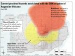
Waythomas, C. F., and Waitt, R. B., 1998, Preliminary volcano-hazard assessment for Augustine Volcano, Alaska: U.S. Geological Survey Open-File Report 98-0106, 39 p., 1 plate, scale unknown.
full-text PDF 2.08 MB
map sheet plate 3.14 MB

Provisional geologic map of Augustine Volcano, Alaska, 1996

Waitt, R. B., and Beget, J. E., 1996, Provisional geologic map of Augustine Volcano, Alaska: U.S. Geological Survey Open-File Report 96-0516, 44 p., 1 plate, scale 1:25,000.
full-text PDF 2.6 MB
map sheet 295 MB!

Catalog and initial analyses of geologic data related to middle and late Quaternary deposits, Cook Inlet region, Alaska, 1996

Reger, R. D., Pinney, D. S., Burke, R. M., and Wiltse, M. A., 1996, Catalog and initial analyses of geologic data related to middle and late Quaternary deposits, Cook Inlet region, Alaska: Alaska Division of Geological & Geophysical Surveys Report of Investigation 95-06, 188 p., 6 sheets, scale 1:250,000.
Hard Copy held by AVO at FBKS - CEC shelf

Volcanoes of Alaska, 1995

Alaska Division of Geological & Geophysical Surveys, 1995, Volcanoes of Alaska: Alaska Division of Geological & Geophysical Surveys Information Circular IC 0038, unpaged, 1 sheet, scale 1:4,000,000.

Aleutian arc volcanoes, 1994

Nye, C. J., 1994, Aleutian arc volcanoes: Alaska Division of Geological & Geophysical Surveys Public-Data File PDF 94-54, unpaged, 1 sheet, scale 1:2,126,841.

This dynamic planet: world map of volcanoes, earthquakes, impact craters, and plate tectonics, 1994

Simkin, Tom, Unger, J. D., Tilling, R. I., Vogt, P. R., and Spall, H. R., 1994, This dynamic planet: world map of volcanoes, earthquakes, impact craters, and plate tectonics: U.S. Geological Survey Special Map unpaged, 1 plate, scale 1:30,000,000.

Geothermal resources of the Aleutian Arc, 1993

Motyka, R. J., Liss, S. A., Nye, C. J., and Moorman, M. A., 1993, Geothermal resources of the Aleutian Arc: Alaska Division of Geological & Geophysical Surveys Professional Report PR 0114, 17 p., 4 sheets, scale 1:1,000,000.
Hard Copy held by AVO at FBKS - CEC shelf

Holocene volcanoes of the Aleutian Arc, Alaska, 1993

March, G. D., 1993, Holocene volcanoes of the Aleutian Arc, Alaska: Alaska Division of Geological & Geophysical Surveys Public-Data File PDF 93-85, unpaged, 1 sheet, scale 1:2,000,000.

Map showing distribution, composition, and age of Late Cenozoic volcanic centers in Alaska, 1986

Luedke, R. G., and Smith, R. L., 1986, Map showing distribution, composition, and age of Late Cenozoic volcanic centers in Alaska: U.S. Geological Survey Miscellaneous Investigations Series Map I 1091-F, unpaged, 3 sheets, scale 1:1,000,000.

Volcanic hazards from future eruptions of Augustine Volcano, Alaska, 1980

Kienle, Juergen, and Swanson, S. E., 1980, Volcanic hazards from future eruptions of Augustine Volcano, Alaska: University of Alaska Fairbanks Geophysical Institute Report UAG-R 275, Fairbanks, AK, University of Alaska, 122 p., 1 sheet, scale unknown.

Geologic map of Alaska, 1980

Beikman, H. M., 1980, Geologic map of Alaska: U.S. Geological Survey Professional Paper PP 0171, unpaged, 1 plate, scale 1:2,500,000.

Volatiles, magma mixing, and the mechanism of eruption at Augustine volcano, Alaska, 1978

Johnston, D. A., 1978, Volatiles, magma mixing, and the mechanism of eruption at Augustine volcano, Alaska: University of Washington Ph.D. dissertation, 187 p., 20 plates, scale unknown.

Geologic map of south Augustine Island, Lower Cook Inlet, Alaska, 1976

Buffler, R. T., 1976, Geologic map of south Augustine Island, Lower Cook Inlet, Alaska: Alaska Division of Geological & Geophysical Surveys Open-File Report AOF 0096, 3 p., 3 sheets, scale 1:24,000.
Hard Copy held by AVO at FBKS - CEC shelf

Geologic map of the Iliamna B-2 Quadrangle, Augustine Island, Alaska, 1973

Detterman, R. L., 1973, Geologic map of the Iliamna B-2 Quadrangle, Augustine Island, Alaska: U.S. Geological Survey Geological Quadrangle Map GQ 1068, 4 p., 1 sheet, scale 1:63,360.

Geology of the Iliamna quadrangle, Alaska, 1968

Detterman, R. L., and Reed, B. L., 1968, Geology of the Iliamna quadrangle, Alaska: U.S. Geological Survey Open-File Report 68-0072, unpaged, 2 plates, scale 1:250,000.

Preliminary map of the geology of the Iliamna quadrangle, Alaska, 1964

Detterman, R. L., and Reed, B. L., 1964, Preliminary map of the geology of the Iliamna quadrangle, Alaska: U.S. Geological Survey Miscellaneous Investigations Series Map I 0407, unpaged, 1 sheet, scale 1:250,000.

Volcanic activity in the Aleutian Arc, 1950

Coats, R. R., 1950, Volcanic activity in the Aleutian Arc: U.S. Geological Survey Bulletin 0974-B, p. 35-49, 1 sheet, scale 1:5,000,000.
plate 1 PDF 819 KB
full-text PDF 783 KB
Hard Copy held by AVO at FBKS - CEC shelf

Reconnaissance of the gold fields of southern Alaska with some notes on general geology, 1898

Becker, G. F., 1898, Reconnaissance of the gold fields of southern Alaska with some notes on general geology: U.S. Geological Survey Annual Report 0018, p. 1-86, 6 sheets, scale unknown.
full-text PDF 1.5 MB
Hard Copy held by AVO at FBKS - CEC file cabinet

Loading Bibliography...

Ash Forecasting

Mathematical models developed by the USGS forecast various aspects of how a volcanic ash plume will interact with wind—where, how high, and how fast ash particles will be transported in the atmosphere, as well as where ash will fall out and accumulate on the ground. AVO runs these models when a volcano is restless by assuming a reasonable hypothetical eruption, to provide a pre-eruptive forecast of areas likely to be affected. During an ongoing eruption, AVO will update the forecast with actual observations (eruption start time and duration, plume height) as they become available.

View the current airborne ash cloud models for Augustine

Ashfall thickness forecast

The Ash3d model was developed by the USGS to forecast how a volcanic ash plume will interact with wind and where ash will fall out and accumulate on the ground. AVO runs these models twice daily when a volcano is restless by assuming a reasonable hypothetical eruption altitude and duration. The map shows the model results of ashfall thickness for areas that are likely to be affected, if one were to occur. During an ongoing eruption, AVO will update the forecast with actual observations (eruption start time and duration, plume height) as they become available, and these plots will be automatically updated. The National Weather Service Anchorage Forecast Office will issue the official ashfall warning product and post them at weather.gov/afc

THESE PRODUCTS MAY NOT BE CURRENT.

During an actual eruption, see National Weather Service forecasts of ashfall:https://weather.gov/afc.

Ashfall Forecast

Click on the X on the graphic (upper right) to expand the map to show the map legend.

Ashfall Start Time

This map shows the modeled estimate of the time it would take for ashfall to begin following an eruption. It corresponds to the ashfall thickness forecast map shown above. This map uses the start time of either the twice-daily hypothetical model runs (time shown in the legend) or the actual eruption start time (if one were to occur). In the case of an actual eruption, the National Weather Service Anchorage Forecast Office will issue the official ashfall warning product that includes the ashfall start time and post them at weather.gov/afc

THESE PRODUCTS MAY NOT BE CURRENT.

During an actual eruption, see National Weather Service forecasts of ashfall:https://weather.gov/afc.

Ashfall Start Times Forecast

Click on the X on the graphic (upper right) to expand the map to show the map legend.
×