Douglas

MarkerMarkerMarkerMarkerMarkerMarkerMarkerMarkerMarkerMarkerMarkerMarkerMarkerMarkerMarkerMarkerMarkerMarkerMarkerMarkerMarkerMarkerMarkerMarkerMarkerMarkerMarkerMarkerMarkerMarkerMarkerMarkerMarkerMarkerMarkerMarkerMarkerMarkerMarkerMarkerMarkerMarkerMarkerMarkerMarkerMarkerMarkerMarkerMarkerMarkerMarkerMarkerMarkerMarkerMarkerMarkerMarkerMarkerMarkerMarkerMarkerMarkerMarkerMarkerMarkerMarkerMarkerMarkerMarkerMarkerMarkerMarkerMarkerMarkerMarkerMarkerMarkerMarkerMarkerMarkerMarkerMarkerMarkerMarkerMarkerMarkerMarkerMarkerMarkerMarkerMarkerMarkerMarkerMarkerMarkerMarkerMarkerMarkerMarkerMarkerMarkerMarkerMarkerMarkerMarkerMarkerMarkerMarkerMarkerMarkerMarkerMarkerMarkerMarkerMarkerMarkerMarkerMarkerMarkerMarkerMarkerMarkerMarkerMarkerMarkerMarkerMarkerMarkerMarkerMarkerMarkerMarkerMarkerMarkerMarkerMarkerMarkerMarkerMarkerMarkerMarkerMarkerMarkerMarkerMarkerMarkerMarkerMarkerMarkerMarkerMarkerMarkerMarkerMarkerMarkerMarkerMarkerMarkerMarkerMarkerMarkerMarkerMarkerMarkerMarkerMarkerMarkerMarkerMarkerMarkerMarkerMarkerMarkerMarkerMarkerMarkerMarkerMarkerMarkerMarkerMarkerMarkerMarkerMarkerMarkerMarkerMarkerMarkerMarkerMarkerMarkerMarkerMarkerMarkerMarkerMarkerMarkerMarkerMarkerMarkerMarkerMarkerMarkerMarkerMarkerMarkerMarkerMarker
Legend
✕
Red (Warning)
Orange (Watch)
Yellow (Advisory)
Green (Normal)
Uninstrumented
Community
Webcam
Instrument
Earthquake Magnitude
0 7+
Earthquake Age
Last 2 Hours
Last 2 Days
Last 1 Week


Facts


  • Official Name: Mount Douglas
  • Seismically Monitored: No
  • Color Code: UNASSIGNED
  • Alert Level: UNASSIGNED
  • Elevation: 2140m (7020ft)
  • Latitude: 58.8596
  • Longitude: -153.5351
  • Smithsonian VNum: 312270
  • Pronunciation:
  • Nearby Towns:
    • Port William 43 mi (69 km) SE
    • Kokhanok 59 mi (95 km) NW
    • Pope-Vannoy Landing 59 mi (95 km) NW
    • Aleneva 63 mi (101 km) SE
    • Afognak 65 mi (105 km) SE

    Distance from Anchorage: 206 mi (331 km)

Description

From Wood and Kienle (1990) [1] : "Mount Douglas is a dissected stratovolcano covered by ice of the Spotted Glacier. The summit of the volcano is marked by a crater with a small (160 m wide) crater lake. An active fumarole field on the north side of the crater keeps the area free of ice. A black scum floating on the lake in 1980 was probably sulfide minerals of some sort (consistent with a lake temperature of 25 degrees C and a pH of 1 measured in 1982).
"Much of the volcano has been subjected to glacial erosion, but a ramp of lava flows on the northwest flank is relatively uneroded. Most of the volcano is ice-covered, but isolated outcrops of lava flows (high-silica andesite) are found within the ice. Reconnaissance geologic surveys suggest that the lavas extend to elevations lower than glacier's, but this has not been confirmed on the ground.
"No historic activity has been reported for Mount Douglas; however, the presence of unglaciated lava flows and the active fumaroles indicate recent activity."

Name Origin

Mount Douglas' name was derived from Cape Douglas, and reported by G.C. Martin in 1904 (Orth, 1971).


References Cited

[1] Volcanoes of North America: United States and Canada, 1990

Wood, C. A., and Kienle, Juergen, (eds.), 1990, Volcanoes of North America: United States and Canada: New York, Cambridge University Press, 354 p.

Reported Activity

Modern Eruptions

Chiginagak

Chiginagak Eruption Timeline

Coats (1950) reports that Chiginagak was smoking in 1852. Powers (1958) writes that Chiginagak was steaming, with intermittent smoke in 1852. Perhaps the original source for this event is Doroshin, who viewed Chiginagak in 1852 and described it as follows (J.B. Kisslinger translation, 1983): "This volcano, which I also saw rising from behind some mountains, has a broad crater, the southern side of which has been destroyed. Snow shows white within the crater. Smoke rises from the western slope of the mountain." This description is probably of the prominent fumaroles on Chiginagak and not a volcanic eruption.

Jaggar (1932): "A mountain to the west of Kanatak was reported fuming in March 1929, and this description might apply to Chiginagak."
However, Miller and others (1998) report that the 1929 eruption of Chiginagak was "based on a brief newspaper account of "unusual activity" at Chiginagak and 6 other volcanoes observed by the crew of a ship which probably passed no closer than 25 km." The December 14, 1929 Associated Press article does not provide further information on Chiginagak, except to say that it is "also on the mainland near Katmai."
Simkin and Siebert (1994) report the eruption as a questionable eruption in December, 1929.

From Miller and others (1998): "Mr. Odon Soeth reported observing an ash eruption in July, 1971 from Port Heiden, 100 km southwest of Chiginagak; according to Mr. Soeth, the eruption lasted only one evening."

Chiginagak 1997/10

October 22, 1997 — August 21, 1998

From McGimsey and Wallace (1999): "On October 22, 1997, AVO began receiving pilot reports of increased steaming, snowmelt, and sulfur smell at Chiginagak. Residents of Pilot Point and surrounding areas also reported that they began noticing an increase in steam emissions possibly as early as mid-summer 1997. A thermal anomaly was detected on Advanced Very High Resolution Radiometer (AVHRR) imagery analyzed on October 23, 1997 [see fig. 10 in original text]. During a flight around the volcano on October 30, AVO scientists observed an enlarged area of fumarolic activity and new fumaroles at about 6,300 ft (~1,900 m), directly above the previously known fumarole site.
"AVO reported the activity at Chiginagak in the weekly update of October 31, 1997, and in updates through year's end, including GVN (Smithsonian Institution, 1997, v. 23, n. 3). Daily, and later weekly, correspondence was maintained with local residents for observations, and AVO closely monitored satellite imagery for signs of increased activity."

From McGimsey and others (2003): "In October 1997, following pilot reports of increased steaming and the presence of a thermal anomaly on satellite imagery, AVO scientists traveled by fixed-wing aircraft to the volcano and observed an enlarged area of fumarolic activity and new fumaroles on the north flank of the volcano (McGimsey and Wallace, 1999). A second observation flight was conducted on March 11, 1998. Winds were relatively calm but the areas of interest were largely obscured. However, observers noticed an absence of steam emissions from the area where the lower fumaroles had been located. Bulbous white clouds lingered above the area of the new fumaroles. A very strong sulfur smell -- much stronger than that from the fall of 1997 -- was reported, as well as a yellow color to the ice that formed on the plane's windows. AVO received no further reports until August 13, 1998, when USFWS personnel and a resident of Pilot Point [see fig. 1a in original text] observed little clouds of "black smoke" accompanied by a "greenish-yellow gas" rising from two point sources to about 500 to 1,000 ft (~150 to 300 m) above the mountain. A dusting of dark material was observed on fresh snow on the upper flanks of the volcano the next morning. On August 15, AVO detected a 30-km-long (19 mi) plume extending east from the volcano. Although the plume contained no ash signal, this was the first time a plume had been observed in satellite imagery of Chiginagak.
"On September 29, 1998, AVO conducted an airborne ultraviolet correlation spectrometer (COSPEC) flight to Chiginagak and measured between 200-300 tonnes per day of SO2 emanating from the fumarolic field. Observers reported a vigorous fumarole at an estimated 1,980 m (6,500 ft) elevation on the north flank, adjacent discolored ice and snow, and a strong sulphur smell [see fig. 8 in original text]. The weaker, second fumarole reported in October 1997 was no longer present.
"AVO described the activity at Chiginagak in the weekly updates of January 2 and 9, 1998 (continued from 1997), and August 14 and 21, 1998. Although no formal call-downs occurred, AVO shared information informally with the FAA following the August activity. AVO maintained contact with local residents and USFWS personnel throughout the year, and AVO closely monitored satellite imagery for signs of increased activity."

Chiginagak 2000/12

December 2000

From Neal and others (2004): "In late December 2000, Navigation Officer Daniel Karlson contacted AVO to report observations of steaming from Chiginagak Volcano in late July and early August during NOAA operations off the Pacific coastline of the Alaska Peninsula. By their estimate, the steaming emanated from a source at approximately 5,200 ft (1,580 m) on the north flank of the volcano, approximately the position of the well-known fumarole long described for Chiginagak. Karlson noted that the cloud was white and constant much of the time, with a few episodes of increased output that extended 'several miles' downwind. He reported that the activity appeared to diminish in intensity over time, ceasing altogether in early August."

From McGimsey and others (2007): "Between November 2004 and early May 2005, a flux of heat to the summit area caused melting of more than 1.3x10^7 cubic m (4.6x10^8 cubic ft) of ice and snow filling the summit crater of Chiginagak, resulting in a 400-m wide (~1,300 ft) and 105-m deep (~350 ft) cauldron containing an acidified lake (Schaefer and others, 2005; J.R. Schaefer and others, AVO/ADGGS, written commun., 2007) (see figs. 25 and 26 in original text). In early May 2005, a catastrophic release of sulfurous, clay-rich debris and acidic water from the lake, with an accompanying acidic aerosol component, traveled 27 km (~17 mi) downstream and flowed into the Mother Goose Lake, headwaters of the King Salmon River (see figs. 27 and 28 in original text). Extensive vegetation damage occurred along the flood route and Mother Goose Lake was acidified (pH of 2.9-3.1), killing all aquatic life and preventing the annual salmon run (J.R. Schaefer and others, AVO/ADGGS, written commun., 2007). AVO volcanologists were to begin the second summer of geologic mapping and hazard assessment at the volcano, but instead responded by documenting the flooding and damage, collecting water samples, measuring water temperature, conductivity, and pH, and surveying the extensive vegetation damage with a U.S. Fish and Wildlife Service botanist. A data-logging seismometer was deployed for about one month with no significant seismicity recorded; Chiginagak currently does not have a seismic network.
"AVO issued an Information Release about the activity on August 23, 2005, shortly after the field crew arrived on site, and an account was related in the Weekly Update (August 26). A summary of preliminary findings is presented by Schaefer and others (2005)."
In the August 23, 2005 Information Release, AVO reported: "An AVO field crew reports that a 1,300 ft (400 m) wide melt-water lake has formed in the snow and ice filled summit crater at Chiginagak Volcano sometime since the last observations in August 2004. Sometime earlier this summer, the southern crater rim of Chiginagak was breached, allowing a portion of the lake to drain. The resulting lahar (a debris flow consisting of a mixture of volcanic sediment, water, and ice) left a deposit on the unnamed glacier draining the crater to the south and caused flooding of 3 to 6 ft (1 to 2 m) above normal on Indecision Creek. Volcano Creek and Mother Goose Lake, the headwaters of King Salmon River, were affected as well. Floodwaters also flowed on and through Chiginagak's southeast glacier, spilling out into an unnamed Pacific drainage leading to Chiginagak Bay. The lahar likely contained acidic water. Although we have no direct samples of the summit lake water, measurements from crater lakes at similar volcanoes have shown pH values ranging from 0 to 3, the acidity arising mainly from sulfuric acid. Vegetation damage was observed along Indecision Creek and the unnamed Pacific drainage.
"The breach in the crater rim and the ensuing lahar probably occurred in July 2005; reports from Painter Creek Lodge at this time tell of strong sulfur smells and cloudy, yellowish water in the Indecision Creek drainage.
"AVO geologists continue to investigate the event and its impacts. There are no indications that an eruption is imminent or that this event is necessarily precursory to an eruption."
Follow-up studies of the area in 2006 revealed that the drainage is still acidic.

Chiginagak 2014/9

September 29, 2014

From Cameron and others, 2017: "On September 30, 2014, AVO received an alert from the National Oceanic and Atmospheric Administration National Environmental Satellite, Data, and Information Service (NOAA-NESDIS) of elevated surface temperatures at Chiginagak volcano observed in MODIS and VIIRS satellite data . The thermal anomaly also was observed in AVHRR satellite data. Worldview data from July 31 and September 28 show no significant change in the summit crater; however, on September 29, AVO received a photograph of the northern flank of the Chiginagak volcano from a resident at lower Ugashik Lake, showing that the long-lived fumarole field on the northern flank had expanded several hundred meters downslope. After September 29, AVO received
no new photographs or satellite observations indicating the presence of this expanded fumarole field, so it is uncertain how long this increase in heat flow persisted. This is the most extensive expansion of the fumarole field that has occurred in recent years, at least since the 2004-2011 field seasons, when repeated visits were made (see northern flank fumarole photographs, fig. 29, in Schaefer and others, 2013)."

Loading

Chiginagak 1852

Chiginagak 1929/3

Chiginagak 1971/7

Chiginagak 1997/10

Chiginagak 2000/12

Chiginagak 2005/5

Chiginagak 2014/9

1440
1450
1460
1470
1480
1490
1500
1510
1520
1530
1540
1550
1560
1570
1580
1590
1600
1610
1620
1630
1640
1650
1660
1670
1680
1690
1700
1710
1720
1730
1740
1750
1760
1770
1780
1790
1800
1810
1820
1830
1840
1850
1860
1870
1880
1890
1900
1910
1920
1930
1940
1950
1960
1970
1980
1990
2000
2010
2020
2030
2040
2050
2060
2070
2080
2090
2100
2110
2120
2130
2140
2150
2160
2170
2180
2190
2200
2210
2220
2230
2240
2250
2260
2270
2280
2290
2300
2310
2320
2330
2340
2350
2360
2370
2380
2390
2400
2410
1811
1812
1813
1814
1815
1816
1817
1818
1819
1821
1822
1823
1824
1825
1826
1827
1828
1829
1831
1832
1833
1834
1835
1836
1837
1838
1839
1841
1842
1843
1844
1845
1846
1847
1848
1849
1851
1852
1853
1854
1855
1856
1857
1858
1859
1861
1862
1863
1864
1865
1866
1867
1868
1869
1871
1872
1873
1874
1875
1876
1877
1878
1879
1881
1882
1883
1884
1885
1886
1887
1888
1889
1891
1892
1893
1894
1895
1896
1897
1898
1899
1901
1902
1903
1904
1905
1906
1907
1908
1909
1911
1912
1913
1914
1915
1916
1917
1918
1919
1921
1922
1923
1924
1925
1926
1927
1928
1929
1931
1932
1933
1934
1935
1936
1937
1938
1939
1941
1942
1943
1944
1945
1946
1947
1948
1949
1951
1952
1953
1954
1955
1956
1957
1958
1959
1961
1962
1963
1964
1965
1966
1967
1968
1969
1971
1972
1973
1974
1975
1976
1977
1978
1979
1981
1982
1983
1984
1985
1986
1987
1988
1989
1991
1992
1993
1994
1995
1996
1997
1998
1999
2001
2002
2003
2004
2005
2006
2007
2008
2009
2011
2012
2013
2014
2015
2016
2017
2018
2019
2021
2022
2023
2024
2025
2026
2027
2028
2029
2031
2032
2033
2034
2035
2036
2037
2038
2039
2041
2042
2043
2044
2045
2046
2047
2048
2049
2051
2052
2053
2054
2055

0 Event Date(s)

Past Activity Legend:
Eruption
Questionable eruption
Non-eruptive activity


Showing 1 - 20 of 62

Map Images


Map References


Recently active volcanoes of Alaska, 2023

Cameron, C.E., Bull, K.F., and Macpherson, A.E., 2023, Recently active volcanoes of Alaska: Alaska Division of Geological & Geophysical Surveys Miscellaneous Publication 133 v. 6, 2 sheets. https://doi.org/10.14509/31086.

Historically active volcanoes of Alaska, v. 3, 2018

Cameron, C.E., Schaefer, J.R., and Mulliken, K.M., 2018, Historically active volcanoes of Alaska: Alaska Division of Geological & Geophysical Surveys Miscellaneous Publication 133 v. 3, 2 sheets. Http://doi.org/10.14509/30142

Historically active volcanoes of Alaska, 2014

Schaefer, J.R., Cameron, C.E., and Nye, C.J., 2014, Historically active volcanoes of Alaska: Alaska Division of Geological & Geophysical Surveys Miscellaneous Publication 133 v. 1.2, 1 sheet, scale 1:3,000,000. This publication has been superseded. Newest version available at http://www.dggs.alaska.gov/pubs/id/20181 .

Preliminary geologic map of the Cook Inlet Region, Alaska - including parts of the Talkeetna, Talkeetna Mountains, Tyonek, Lake Clark, Kenai, Seward, Iliamna, Seldovia, Mount Katmai, and Afognak 1:250,000-scale Quadrangles, 2009

Wilson, F.H., Hults, C.P., Schmoll, H.R., Haeussler, P.J., Schmidt, J.M., Yehle, L.A., and Labay, K.A., compilers; digital files prepared by Wilson, F.H., Hults, C.P., Labay, K.A., and Shew, Nora, 2009, Preliminary geologic map of the Cook Inlet Region, Alaska - including parts of the Talkeetna, Talkeetna Mountains, Tyonek, Lake Clark, Kenai, Seward, Iliamna, Seldovia, Mount Katmai, and Afognak 1:250,000-scale Quadrangles: U.S. Geological Survey Open-File Report 2009-1108, scale 1:250:000, available at http://pubs.usgs.gov/of/2009/1108/ .

Volcanoes of Alaska, 1998

Nye, C. J., Queen, Katherine, and McCarthy, A. M., 1998, Volcanoes of Alaska: Alaska Division of Geological & Geophysical Surveys Information Circular IC 0038, unpaged, 1 sheet, scale 1:4,000,000, available at http://www.dggs.dnr.state.ak.us/pubs/pubs?reqtype=citation&ID=7043 .
Hard Copy held by AVO at FBKS - CEC shelf

Volcanoes of Alaska, 1995

Alaska Division of Geological & Geophysical Surveys, 1995, Volcanoes of Alaska: Alaska Division of Geological & Geophysical Surveys Information Circular IC 0038, unpaged, 1 sheet, scale 1:4,000,000.

Geothermal resources of the Aleutian Arc, 1993

Motyka, R. J., Liss, S. A., Nye, C. J., and Moorman, M. A., 1993, Geothermal resources of the Aleutian Arc: Alaska Division of Geological & Geophysical Surveys Professional Report PR 0114, 17 p., 4 sheets, scale 1:1,000,000.
Hard Copy held by AVO at FBKS - CEC shelf

Quaternary geologic map of the Mount Katmai quadrangle and adjacent parts of the Naknek and Afognak quadrangles, Alaska, 1993

Riehle, J. R., and Detterman, R. L., 1993, Quaternary geologic map of the Mount Katmai quadrangle and adjacent parts of the Naknek and Afognak quadrangles, Alaska: U.S. Geological Survey Miscellaneous Investigations Series Map I 2032, unpaged, 1 sheet, scale 1:250,000.

Holocene volcanoes of the Aleutian Arc, Alaska, 1993

March, G. D., 1993, Holocene volcanoes of the Aleutian Arc, Alaska: Alaska Division of Geological & Geophysical Surveys Public-Data File PDF 93-85, unpaged, 1 sheet, scale 1:2,000,000.

Map showing potassium-argon ages from the Mount Katmai and adjacent parts of the Naknek and Afognak quadrangles, Alaska Peninsula, Alaska, 1992

Shew, Nora, and Lanphere, M. A., 1992, Map showing potassium-argon ages from the Mount Katmai and adjacent parts of the Naknek and Afognak quadrangles, Alaska Peninsula, Alaska: U.S. Geological Survey Miscellaneous Field Studies Map MF 2021-E, unpaged, 1sheet, scale 1:250,000.

Map showing distribution, composition, and age of Late Cenozoic volcanic centers in Alaska, 1986

Luedke, R. G., and Smith, R. L., 1986, Map showing distribution, composition, and age of Late Cenozoic volcanic centers in Alaska: U.S. Geological Survey Miscellaneous Investigations Series Map I 1091-F, unpaged, 3 sheets, scale 1:1,000,000.

References

Proximity to active volcanoes enhances glacier velocity, 2024

Mallalieu, J., Barr, I.D., Spagnolo, M., Mullan, D.J., Symeonakis, E., Edwards, B.R., and Martin, M.D., 2024, Proximity to active volcanoes enhances glacier velocity: Communications Earth & Environment v. 5, 679. https://doi.org/10.1038/s43247-024-01826-5
Full-text PDF 1.3 MB

Recently active volcanoes of Alaska, 2023

Cameron, C.E., Bull, K.F., and Macpherson, A.E., 2023, Recently active volcanoes of Alaska: Alaska Division of Geological & Geophysical Surveys Miscellaneous Publication 133 v. 6, 2 sheets. https://doi.org/10.14509/31086.

Weak degassing from remote Alaska volcanoes characterized with a new airborne imaging DOAS instrument and a suite of in situ sensors, 2023

Kern, C., and Kelly, P.J., 2023, Weak degassing from remote Alaska volcanoes characterized with a new airborne imaging DOAS instrument and a suite of in situ sensors: Fronteirs in Earth Science v. 11, 1088056. https://doi.org/10.3389/feart.2023.1088056.

Understanding drivers of mercury in lake trout (Salvelinus namaycush), a top-predator fish in southwest Alaska's parklands, 2023

Bartz, K.K., Hannam, M.P., Wilson, T.L., Lepak, R.F., Ogorek, J.M., Young, D.B., Eagles-Smith, C.A., and Krabbenhoft, D.P., 2023, Understanding drivers of mercury in lake trout (Salvelinus namaycush), a top-predator fish in southwest Alaska's parklands: Environmental Pollution v. 330, 121678. https://doi.org/10.1016/j.envpol.2023.121678
Full-text PDF 3.8 MB

Selected crater and small caldera lakes in Alaska: Characteristics and hazards, 2022

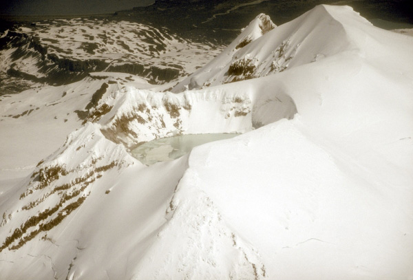
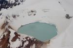
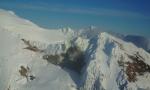
Waythomas, C.F., 2022, Selected crater and small caldera lakes in Alaska: Characteristics and hazards: Frontiers in Earth Science, v. 9, p. 23, doi:10.3389/feart.2021.751216.

Geologic database of information on volcanoes in Alaska (GeoDIVA), 2022

Cameron, C.E., Crass, S.W., and AVO Staff, eds, 2022, Geologic database of information on volcanoes in Alaska (GeoDIVA): Alaska Division of Geologic and Geophysical Surveys Digital Data Series 20, https://doi.org/10.14509/geodiva, https://doi.org/10.14509/30901.

2016 Volcanic activity in Alaska - Summary of events and response of the Alaska Volcano Observatory, 2020

Cameron, C.E., Dixon, J.P., Waythomas, C.F., Iezzi, A.M., Wallace, K.L., McGimsey, R.G., and Bull, K.F., 2020, 2016 Volcanic activity in Alaska-Summary of events and response of the Alaska Volcano Observatory: U.S. Geological Survey Scientific Investigations Report 2020-5125, 63 p., https://doi.org/10.3133/sir20205125.

Geochemistry of some Quaternary lavas from the Aleutian Arc and Mt. Wrangell, 2018

Nye, C.J., Beget, J.E., Layer, P.W., Mangan, M.T., McConnell, V.S., McGimsey, R.G., Miller, T.P., Moore, R.B., and Stelling, P.L., 2018, Geochemistry of some quaternary lavas from the Aleutian Arc and Mt. Wrangell: Alaska Division of Geological & Geophysical Surveys Raw Data File 2018-1, 29 p. http://doi.org/10.14509/29843

2018 update to the U.S. Geological Survey national volcanic threat assessment, 2018

Ewert, J.W., Diefenbach, A.K., and Ramsey, D.W., 2018, 2018 update to the U.S. Geological Survey national volcanic threat assessment: U.S. Geological Survey Scientific Investigations Report 2018-5140, 40 p., https://pubs.usgs.gov/sir/2018/5140/sir20185140.pdf.

Historically active volcanoes of Alaska, v. 3, 2018

Cameron, C.E., Schaefer, J.R., and Mulliken, K.M., 2018, Historically active volcanoes of Alaska: Alaska Division of Geological & Geophysical Surveys Miscellaneous Publication 133 v. 3, 2 sheets. Http://doi.org/10.14509/30142

Historically active volcanoes of Alaska, 2016

Cameron, C.E., and Schaefer, J.R., 2016, Historically active volcanoes of Alaska: Alaska Division of Geological & Geophysical Surveys Miscellaneous Publication 133 v. 2, 1 sheet, scale 1:3,000,000. http://doi.org/10.14509/20181

Alaska Volcano Observatory image database, 2016

Cameron, C.E., and Snedigar, S.F., 2016, Alaska Volcano Observatory image database: Alaska Division of Geological & Geophysical Surveys Digital Data Series 13, https://www.avo.alaska.edu/images/. https://doi.org/10.14509/29689.

Historically active volcanoes of Alaska, 2014

Schaefer, J.R., Cameron, C.E., and Nye, C.J., 2014, Historically active volcanoes of Alaska: Alaska Division of Geological & Geophysical Surveys Miscellaneous Publication 133 v. 1.2, 1 sheet, scale 1:3,000,000. This publication has been superseded. Newest version available at http://www.dggs.alaska.gov/pubs/id/20181 .

Regional controls on volcano seismicity along the Aleutian Arc, 2014

Buurman, Helena, Nye, C.J., West, M.E., and Cameron, Cheryl, 2014, Regional controls on volcano seismicity along the Aleutian Arc: Geochemistry, Geophysics, Geosystems, doi:10.1002/2013GC005101

Preliminary database of Quaternary vents in Alaska, 2014

Cameron, C.E., and Nye, C.J., 2014, Preliminary database of Quaternary vents in Alaska: Alaska Division of Geological & Geophysical Surveys Miscellaneous Publication 153, 11 p., doi:10.14509/27357 .

InSAR imaging of Aleutian volcanoes, 2014

Lu, Zhong, and Dzurisin, Daniel, 2014, InSAR imaging of Aleutian volcanoes: Chichester, UK, Springer-Praxis, 390 p.

Katmai scientific studies, 2012

Winfree, Robert, with contributions from Bacon, C.R., Bennett, A.J., Bennington, Ninfa, Berg, E.E., Brooks, Margi, Coletti, H.A., Coombs, M.L., Fierstein, Judy, Freeburg, Gary, Frost, G.V., Haney, Matthew, Jorgenson, M.T., Miller, A.E., Moran, Seth, Murphy, Rachel, Partnow, Patricia, Paskievitch, John, Stevens, D.P., Powell, Lee, Power, John, Prejean, S.G., Schaaf, Jeanne, Sherriff, R.L., Thurber, Clifford, and Welchman, R.A., 2012, Katmai science studies: Alaska Park Science Journal, v. 11, n. 1, 96 p., available online at http://www.nps.gov/akso/nature/science/ak_park_science/volume_11_issue_1.cfm .

Preliminary geologic map of the Cook Inlet Region, Alaska - including parts of the Talkeetna, Talkeetna Mountains, Tyonek, Lake Clark, Kenai, Seward, Iliamna, Seldovia, Mount Katmai, and Afognak 1:250,000-scale Quadrangles, 2009

Wilson, F.H., Hults, C.P., Schmoll, H.R., Haeussler, P.J., Schmidt, J.M., Yehle, L.A., and Labay, K.A., compilers; digital files prepared by Wilson, F.H., Hults, C.P., Labay, K.A., and Shew, Nora, 2009, Preliminary geologic map of the Cook Inlet Region, Alaska - including parts of the Talkeetna, Talkeetna Mountains, Tyonek, Lake Clark, Kenai, Seward, Iliamna, Seldovia, Mount Katmai, and Afognak 1:250,000-scale Quadrangles: U.S. Geological Survey Open-File Report 2009-1108, scale 1:250:000, available at http://pubs.usgs.gov/of/2009/1108/ .

Preliminary spreadsheet of eruption source parameters for volcanoes of the world, 2009

Mastin, L.G., Guffanti, Marianne, Ewert, J.E., and Spiegel, Jessica, 2009, Preliminary spreadsheet of eruption source parameters for volcanoes of the world: U.S. Geological Survey Open-File Report 2009-1133, v. 1.2, 25 p., available at http://pubs.usgs.gov/of/2009/1133/ .

Historically active volcanoes of Alaska reference deck, 2009

Snedigar, S.F., and Cameron, C.C., 2009, Historically active volcanoes of Alaska reference deck: Alaska Division of Geological & Geophysical Surveys Information Circular 59, 52 p, available to order from http://www.dggs.dnr.state.ak.us/pubs/pubs?reqtype=citation&ID=20401 .

The Alaska Volcano Observatory - 20 years of volcano research, monitoring, and eruption response, 2008

Schaefer, J.R., and Nye, Chris, 2008, The Alaska Volcano Observatory - 20 years of volcano research, monitoring, and eruption response: Alaska Division of Geological & Geophysical Surveys, Alaska GeoSurvey News, NL 2008-001, v. 11, n. 1, p. 1-9, available at http://wwwdggs.dnr.state.ak.us/pubs/pubs?reqtype=citation&ID=16061 .

System for ranking relative threats of U.S. volcanoes, 2007

Ewert, John, 2007, System for ranking relative threats of U.S. volcanoes: Natural Hazards Review, v. 8, n. 4, p. 112-124.

A compilation of gas emission-rate data from volcanoes of Cook Inlet (Spurr, Crater Peak, Redoubt, Iliamna, and Augustine) and Alaska Peninsula (Douglas, Fourpeaked, Griggs, Mageik, Martin, Peulik, Ukinrek Maars, and Veniaminof), Alaska, from 1995-2006, 2007

Doukas, M.P., and McGee, K.A., 2007, A compilation of gas emission-rate data from volcanoes of Cook Inlet (Spurr, Crater Peak, Redoubt, Iliamna, and Augustine) and Alaska Peninsula (Douglas, Fourpeaked, Griggs, Mageik, Martin, Peulik, Ukinrek Maars, and Veniaminof), Alaska, from 1995-2006: U.S. Geological Survey Open-File Report 2007-1400, 13 p., available at http://pubs.usgs.gov/of/2007/1400/ .

The National Volcano Early Warning System (NVEWS), 2006

Ewert, John, Guffanti, Marianne, Cervelli, Peter, and Quick, James, 2006, The National Volcano Early Warning System (NVEWS): U.S. Geological Survey Fact Sheet FS 2006-3142, 2 p., available at http://pubs.usgs.gov/fs/2006/3142 .

USGS-NoGaDat - A global dataset of noble gas concentrations and their isotopic ratios in volcanic systems, 2006

Abedini, A.A., Hurwitz, S., and Evans, W.C., 2006, USGS-NoGaDat - A global dataset of noble gas concentrations and their isotopic ratios in volcanic systems: U.S. Geological Survey Data Series 202, available at http://pubs.usgs.gov/ds/2006/202/ .

An assessment of volcanic threat and monitoring capabilities in the United States: framework for a National Volcano Early Warning System NVEWS, 2005

Ewert, J.W., Guffanti, Marianne, and Murray, T.L., 2005, An assessment of volcanic threat and monitoring capabilities in the United States: framework for a National Volcano Early Warning System NVEWS: U.S. Geological Survey Open-File Report 2005-1164, 62 p.
full-text PDF 2.90 MB

Volcanoes of the world: an illustrated catalog of Holocene volcanoes and their eruptions, 2003

Siebert, L., and Simkin, T., 2002-, Volcanoes of the world: an illustrated catalog of Holocene volcanoes and their eruptions: Smithsonian Institution, Global Volcanism Program Digital Information Series GVP-3, http://volcano.si.edu/search_volcano.cfm, unpaged internet resource.

Bibliography of information on Alaska volcanoes, 2003

Cameron, C. E., Triplehorn, J. H., and Robar, C. L., 2003, Bibliography of information on Alaska volcanoes: Alaska Division of Geological & Geophysical Surveys Miscellaneous Publication MP 131, 1 CD-ROM.
Hard Copy held by AVO at FBKS - CEC file cabinet

Volcanoes of Alaska, 1998

Nye, C. J., Queen, Katherine, and McCarthy, A. M., 1998, Volcanoes of Alaska: Alaska Division of Geological & Geophysical Surveys Information Circular IC 0038, unpaged, 1 sheet, scale 1:4,000,000, available at http://www.dggs.dnr.state.ak.us/pubs/pubs?reqtype=citation&ID=7043 .
Hard Copy held by AVO at FBKS - CEC shelf

Volcanoes of the Alaska Peninsula and Aleutian Islands selected photographs, 1997

Neal, Christina, and McGimsey, R. G., 1997, Volcanoes of the Alaska Peninsula and Aleutian Islands selected photographs: U.S. Geological Survey Digital Data Series DDS 0040, 1 CD-ROM.

Stratigraphic framework of the Alaska Peninsula, 1996

Detterman, R. L., Case, J. E., Miller, J. W., Wilson, F. H., and Yount, M. E., 1996, Stratigraphic framework of the Alaska Peninsula: U.S. Geological Survey Bulletin 1969-A, 74 p.
full-text PDF 2.7 MB

Bibliography for Hayes, Spurr, Crater Peak, Redoubt, Iliamna, Augustine, Douglas, and Aniakchak volcanoes, Alaska, 1995

Lemke, K. J., May, B. A., and Vanderpool, A. M., 1995, Bibliography for Hayes, Spurr, Crater Peak, Redoubt, Iliamna, Augustine, Douglas, and Aniakchak volcanoes, Alaska: U.S. Geological Survey Open-File Report 95-0435, 33 p.
Hard Copy held by AVO at FBKS - CEC file cabinet

Comparative geochemistry of some volcanoes of the easternmost Aleutian Arc, 1995

Nye, C. J., 1995, Comparative geochemistry of some volcanoes of the easternmost Aleutian Arc [abs.]: Abstracts with Programs - Geological Society of America, v. 27, n. 5, p. 69.

Contamination by heterogeneous continental crust in easternmost Aleutian Arc volcanoes: and implications for the rest of the arc, 1995

Nye, C. J., and Spring, S. A., 1995, Contamination by heterogeneous continental crust in easternmost Aleutian Arc volcanoes: and implications for the rest of the arc [abs.]: Eos, v. 76, n. 46, p. 655.

Volcanoes of Alaska, 1995

Alaska Division of Geological & Geophysical Surveys, 1995, Volcanoes of Alaska: Alaska Division of Geological & Geophysical Surveys Information Circular IC 0038, unpaged, 1 sheet, scale 1:4,000,000.

Mesozoic macrofossil locality map, checklists, and pre-Quaternary stratigraphic section of the Mt. Katmai and adjacent parts of the Afognak and Naknek quadrangles, Alaska Peninsula, Alaska, 1995

Miller, J.W., Elder, W.P., and Detterman, R.L., 1995, Mesozoic macrofossil locality map, checklists, and pre-Quaternary stratigraphic section of the Mt. Katmai and adjacent parts of the Afognak and Naknek quadrangles, Alaska Peninsula, Alaska: U.S. Geological Survey Miscellaneous Field Studies Map 2021-G, 3 sheets. https://doi.org/10.3133/mf2021G

Volcanic eruptions and tsunami generation in the eastern Aleutian arc: the geologic record, 1994

Beget, J. E., 1994, Volcanic eruptions and tsunami generation in the eastern Aleutian arc: the geologic record [abs.]: Abstracts with Programs - Geological Society of America, v. 26, n. 7, p. A138.

Mineral-resource assessments in Alaska: background information to accompany maps and reports about geology and undiscovered-mineral-resource potential of the Mount Katmai quadrangle and adjacent parts of the Naknek and Afognak quadrangles, Alaska Peninsula, 1994

Riehle, J. R., Church, S. E., Detterman, R. L., and Miller, J. W., 1994, Mineral-resource assessments in Alaska: background information to accompany maps and reports about geology and undiscovered-mineral-resource potential of the Mount Katmai quadrangle and adjacent parts of the Naknek and Afognak quadrangles, Alaska Peninsula: U.S. Geological Survey Circular C 1106, 13 p.

Volcanoes of the world [2nd edition], 1994

Simkin, Tom, and Siebert, Lee, 1994, Volcanoes of the world [2nd edition]: Tucson, Arizona, Geoscience Press, 349 p.
Hard Copy held by AVO at FBKS - CEC shelf

Quaternary volcanism in the Alaska Peninsula and Wrangell Mountains, Alaska, 1994

Miller, T. P., and Richter, D. H., 1994, Quaternary volcanism in the Alaska Peninsula and Wrangell Mountains, Alaska: in Plafker, George, Jones, D. L., and Berg, H. C., (eds.), The Geology of Alaska, Geological Society of America The Geology of North America series v. G-1, p. 759-779.
Hard Copy held by AVO at FBKS - CEC file cabinet

Geothermal resources of the Aleutian Arc, 1993

Motyka, R. J., Liss, S. A., Nye, C. J., and Moorman, M. A., 1993, Geothermal resources of the Aleutian Arc: Alaska Division of Geological & Geophysical Surveys Professional Report PR 0114, 17 p., 4 sheets, scale 1:1,000,000.
Hard Copy held by AVO at FBKS - CEC shelf

Quaternary geologic map of the Mount Katmai quadrangle and adjacent parts of the Naknek and Afognak quadrangles, Alaska, 1993

Riehle, J. R., and Detterman, R. L., 1993, Quaternary geologic map of the Mount Katmai quadrangle and adjacent parts of the Naknek and Afognak quadrangles, Alaska: U.S. Geological Survey Miscellaneous Investigations Series Map I 2032, unpaged, 1 sheet, scale 1:250,000.

Holocene volcanoes of the Aleutian Arc, Alaska, 1993

March, G. D., 1993, Holocene volcanoes of the Aleutian Arc, Alaska: Alaska Division of Geological & Geophysical Surveys Public-Data File PDF 93-85, unpaged, 1 sheet, scale 1:2,000,000.

Geology and geochemistry of Mt. Douglas volcano, eastern Aleutian arc, Alaska, 1992

Nye, C. J., Beget, J. E., Motyka, R. J., and Layer, P. W., 1992, Geology and geochemistry of Mt. Douglas volcano, eastern Aleutian arc, Alaska [abs.]: Eos, v. 73, p. 634.

Map showing potassium-argon ages from the Mount Katmai and adjacent parts of the Naknek and Afognak quadrangles, Alaska Peninsula, Alaska, 1992

Shew, Nora, and Lanphere, M. A., 1992, Map showing potassium-argon ages from the Mount Katmai and adjacent parts of the Naknek and Afognak quadrangles, Alaska Peninsula, Alaska: U.S. Geological Survey Miscellaneous Field Studies Map MF 2021-E, unpaged, 1sheet, scale 1:250,000.

Resource assessment of the Mount Katmai 1x2 deg quadrangle and adjacent parts of the Naknek and Afognak quadrangles, Alaska Peninsula, 1991

Riehle, J. R., Church, S. E., and Magoon, L. B., 1991, Resource assessment of the Mount Katmai 1x2 deg quadrangle and adjacent parts of the Naknek and Afognak quadrangles, Alaska Peninsula [abs.]: in Good, E. G., Slack, J. F., and Kotra, R. K., (eds.), USGS Research on Mineral Resources-1991 Program and Abstracts, U.S. Geological Survey Circular C 1062, p. 65-66.

Alaska Volcano Observatory summary report: July 1, 1991 - August 31, 1991, 1991

Neal, C. (compiler), 1991, Alaska Volcano Observatory summary report: July 1, 1991 - August 31, 1991: Alaska Volcano Observatory bimonthly report series, 15 p.

The Alaska Volcano Observatory: a multisite, multiagency consortium for volcano monitoring and research, 1990

Davies, J. N., Miller, T. P., Power, J. A., and Forbes, R. B., 1990, The Alaska Volcano Observatory: a multisite, multiagency consortium for volcano monitoring and research [abs.]: Eos, v. 71, n. 43, p. 1709.

Volcanoes of North America: United States and Canada, 1990

Wood, C. A., and Kienle, Juergen, (eds.), 1990, Volcanoes of North America: United States and Canada: New York, Cambridge University Press, 354 p.
Hard Copy held by AVO at FBKS - CEC shelf

Sample locality maps, analytical data, and statistical summary of analyses of rock samples from the Mount Katmai quadrangle and adjacent portions of the Naknek and Afognak quadrangles, Alaska, 1989

Riehle, J. R., Bailey, R. A., and Church, S. E., 1989, Sample locality maps, analytical data, and statistical summary of analyses of rock samples from the Mount Katmai quadrangle and adjacent portions of the Naknek and Afognak quadrangles, Alaska: U.S. Geological Survey Open-File Report 89-0570, 136 p.

Map showing distribution, composition, and age of Late Cenozoic volcanic centers in Alaska, 1986

Luedke, R. G., and Smith, R. L., 1986, Map showing distribution, composition, and age of Late Cenozoic volcanic centers in Alaska: U.S. Geological Survey Miscellaneous Investigations Series Map I 1091-F, unpaged, 3 sheets, scale 1:1,000,000.

Magmatism and subduction in the eastern Aleutian Arc, 1983

Kienle, J., Swanson, S. E., and Pulpan, H., 1983, Magmatism and subduction in the eastern Aleutian Arc: in Shimozuru, D. and Yokoyama, I., (eds.), Arc volcanism: physics and tectonics, IAVCEI symposium, Proceedings, Tokyo and Hakone, Japan, Aug. 3l -Sept. 5, 1981, Tokyo, Terra Scientific Publishing Co., p. 191-224.
Hard Copy held by AVO at FBKS - CEC file cabinet

Volcanism in the eastern Aleutian Arc: late Quaternary and Holocene centers, tectonic setting and petrology, 1983

Kienle, Juergen, and Swanson, S. E., 1983, Volcanism in the eastern Aleutian Arc: late Quaternary and Holocene centers, tectonic setting and petrology: Journal of Volcanology and Geothermal Research, v. 17, n. 1-4, p. 393-432.
Hard Copy held by AVO at FBKS - CEC file cabinet

Plate subduction and volcanism in the eastern Aleutian Arc: 2, Petrology, 1982

Swanson, S. E., and Kienle, Juergen, 1982, Plate subduction and volcanism in the eastern Aleutian Arc: 2, Petrology [abs.]: Abstracts with Programs - Geological Society of America, v. 14, n. 7, p. 628.

The Aleutians, 1982

Marsh, B. D., 1982, The Aleutians: in Thorpe, R. S., (ed.), Andesites: orogenic andesites and related rocks, Chichester, United Kingdom, John Wiley & Sons, p. 99-114.
Hard Copy held by AVO at FBKS - CEC file cabinet

Volcanic centers in the Katmai area, Alaska, 1981

Kienle, Juergen, Swanson, S. E., and Pulpan, Hans, 1981, Volcanic centers in the Katmai area, Alaska [abs.]: Eos, v. 62, n. 17, p. 430.

Volcanoes of the world, 1981

Simkin, Tom, Siebert, Lee, McClelland, Lindsay, Bridge, David, Newhall, Christopher, and Latter, J. H., 1981, Volcanoes of the world: Stroudsburg, PA, Hutchinson Publishing Company, 233 p.

Transverse tectonic boundaries near Kodiak Island, 1981

Fisher, M. A., Bruns, T. R., and vonHuene, Roland, 1981, Transverse tectonic boundaries near Kodiak Island: Geological Society of America Bulletin, v. 92, p. 10-18.

People and pumice on the Alaska Peninsula, 1979

Dumond, D. E., 1979, People and pumice on the Alaska Peninsula: in Sheets, P. D. and Grayson, D. K., (eds.), Volcanic activity and human ecology, New York, NY, Academic Press, p. 373-390.
Hard Copy held by AVO at FBKS - CEC file cabinet

Comprehensive tables giving physical data and thermal energy estimates for young igneous systems of the United States, 1978

Smith, R. L., Shaw, H. R., Luedke, R. G., and Russell, S. L., 1978, Comprehensive tables giving physical data and thermal energy estimates for young igneous systems of the United States: U.S. Geological Survey Open-File Report 78-0925, p. 1-25.
Hard Copy held by AVO at FBKS - CEC shelf

Glaciers of the Aleutian Range and Kodiak Island, 1975

Denton, G. H., and Field, W. O., 1975, Glaciers of the Aleutian Range and Kodiak Island: in Field, W. O., (ed.), Mountain glaciers of the Northern Hemisphere, v. 2, Hanover, NH, Cold Regions Research and Engineering Laboratory, p. 621-638.

Exploring Katmai National Monument and the Valley of Ten Thousand Smokes, 1974

Alaska Travel Publications, 1974, Exploring Katmai National Monument and the Valley of Ten Thousand Smokes: Anchorage, AK, Alaska Travel Publications, p. 49-69, 71-75, 85-98.

Gravity survey in the general area of the Katmai National Monument, Alaska, 1968

Kienle, Juergen, 1968, Gravity survey in the general area of the Katmai National Monument, Alaska: University of Alaska Fairbanks Ph.D. dissertation, 151 p.

Microearthquake study of Mount Katmai and vicinity, Alaska, 1967

Matumoto, Tosimatu, and Ward, P. L., 1967, Microearthquake study of Mount Katmai and vicinity, Alaska: Journal of Geophysical Research, v. 72, n. 10, p. 2557-2568.

Evidence for magma in the Katmai volcanic range, 1967

Kubota, S., and Berg, E., 1967, Evidence for magma in the Katmai volcanic range: Bulletin Volcanologique, v. 31, p. 175-214.
Hard Copy held by AVO at FBKS - CEC file cabinet

Seismic and gravity studies at Katmai, 1966

Berg, E., Kubota, S., and Kienle, J., 1966, Seismic and gravity studies at Katmai: University of Alaska Geophysical Institute Annual Report, 1965-66, p. 64-65.
Hard Copy held by AVO at FBKS - CEC file cabinet

Geology of the Mount Katmai area, Alaska, 1959

Keller, A. S., and Reiser, H. N., 1959, Geology of the Mount Katmai area, Alaska: U.S. Geological Survey Bulletin 1058-G, p. 261-298, 2 sheets, scale 1:250,000.
plate 29 PDF 32 MB
Hard Copy held by AVO at FBKS - CEC shelf

Alaska Peninsula-Aleutian Islands, 1958

Powers, H. A., 1958, Alaska Peninsula-Aleutian Islands: in Williams, H., (ed.), Landscapes of Alaska, Los Angeles, CA, University of California Press, p. 61-75.

Current volcanic activity in Katmai National Monument, 1954

Muller, E. H., Juhle, R. W., and Coulter, H. W., 1954, Current volcanic activity in Katmai National Monument: in Luntey, R. S., Interim report on Katmai Project, Washington D.C., U.S. National Park Service, p. 62-66.
Hard Copy held by AVO at FBKS - CEC file cabinet

United States coast pilot, Alaska Part 2, Yakutat Bay to Arctic Ocean, 1947

U.S. Department of Commerce, and Coast and Geodetic Survey, 1947, United States coast pilot, Alaska Part 2, Yakutat Bay to Arctic Ocean: Washington DC, United States Government Printing Office, 659 p.

Past volcanic activity in the Aleutian arc,

Coats, R. R., Past volcanic activity in the Aleutian arc: U.S. Geological Survey Volcano Investigations Report 1, 18 p.
full-text PDF 22.3 MB
Hard Copy held by AVO at FBKS - CEC file cabinet