


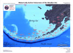
Katmai
Katmai Eruption Timeline
| Red (Warning) | |
| Orange (Watch) | |
| Yellow (Advisory) | |
| Green (Normal) | |
| Uninstrumented | |
| Community | |
| Webcam | |
| Instrument | |
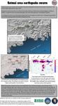
| Earthquake Magnitude | |
|
0
| |
| Earthquake Age | |
| Last 2 Hours | |
| Last 2 Days | |
| Last 1 Week | |
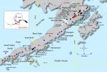
Distance from Anchorage: 269 mi (432 km)
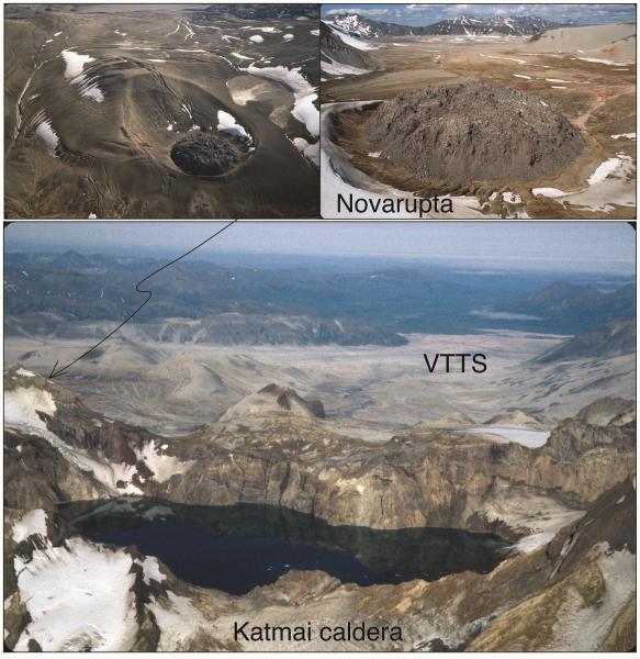
This locality was published as "Katmai Volcano" in 1910 by the U.S. Coast and Geodetic Survey, and as "Mount Katmai" by G.C. Martin in 1913. "Mount Katmai" is the current proper name (Orth, 1971).
Strong northwesterly winds in the vicinity of Katmai and the Valley of Ten Thousand Smokes have picked up loose volcanic ash erupted during the 1912 Novarupta-Katmai eruption and are carrying it to the southeast toward Kodiak Island. The National Weather Service has issued a SIGMET for this low-level event and suggests that the maximum cloud height is 6,000 ft (1.8 km) above sea level.
This phenomenon is not the result of recent volcanic activity and occurs during times of high winds and dry snow-free conditions in the Katmai area and other young volcanic areas of Alaska. No eruption is in progress. All of the volcanoes of the Katmai area (Griggs, Katmai, Novarupta, Mageik, Martin, Snowy and Trident) remain at Aviation Color Code GREEN and Alert Level NORMAL. Resuspended volcanic ash should be considered hazardous and could be damaging to aircraft and health.
For more information on volcanic ash and human health, visit the following website: http://volcanoes.usgs.gov/ash/
Official warnings about these ash resuspension events are issued by the National Weather Service: https://www.weather.gov/afc/
Forecasts of airborne ash hazard to aircraft: https://www.weather.gov/aawu/. Volcanic Ash Advisories: https://www.weather.gov/vaac/
Forecasts of ashfall: http://www.weather.gov/afc
Air quality hazards and guidance from Alaska Department of Environmental Conservation, Division of Air Quality: http://dec.alaska.gov/Applications/Air/airtoolsweb/Advisories/Index
| Eruption | |
| Questionable eruption | |
| Non-eruptive activity |


Mathematical models developed by the USGS forecast various aspects of how a volcanic ash plume will interact with wind—where, how high, and how fast ash particles will be transported in the atmosphere, as well as where ash will fall out and accumulate on the ground. AVO runs these models when a volcano is restless by assuming a reasonable hypothetical eruption, to provide a pre-eruptive forecast of areas likely to be affected. During an ongoing eruption, AVO will update the forecast with actual observations (eruption start time and duration, plume height) as they become available.
The Ash3d model was developed by the USGS to forecast how a volcanic ash plume will interact with wind and where ash will fall out and accumulate on the ground. AVO runs these models twice daily when a volcano is restless by assuming a reasonable hypothetical eruption altitude and duration. The map shows the model results of ashfall thickness for areas that are likely to be affected, if one were to occur. During an ongoing eruption, AVO will update the forecast with actual observations (eruption start time and duration, plume height) as they become available, and these plots will be automatically updated. The National Weather Service Anchorage Forecast Office will issue the official ashfall warning product and post them at weather.gov/afc
THESE PRODUCTS MAY NOT BE CURRENT.During an actual eruption, see National Weather Service forecasts of ashfall:https://weather.gov/afc.
This map shows the modeled estimate of the time it would take for ashfall to begin following an eruption. It corresponds to the ashfall thickness forecast map shown above. This map uses the start time of either the twice-daily hypothetical model runs (time shown in the legend) or the actual eruption start time (if one were to occur). In the case of an actual eruption, the National Weather Service Anchorage Forecast Office will issue the official ashfall warning product that includes the ashfall start time and post them at weather.gov/afc
THESE PRODUCTS MAY NOT BE CURRENT.During an actual eruption, see National Weather Service forecasts of ashfall:https://weather.gov/afc.