Rainbow River cone
Spurr
Great Sitkin
Akutan
Aniakchak
Atka volcanic complex
Augustine
Cleveland
Dutton
Edgecumbe
Fisher
Gareloi
Great Sitkin
Griggs
Iliamna
Isanotski
Kanaga
Katmai
Little Sitkin
Mageik
Makushin
Martin
Novarupta
Pavlof
Redoubt
Semisopochnoi
Shishaldin
Snowy
Spurr
Takawangha
Tanaga
Trident
Ugashik-Peulik
Ukinrek Maars
Veniaminof
Westdahl
Wrangell
Adagdak
Addington volcanic field
Alagogshak
Amak
Amchixtam Chaxsxii
Amukta
Andrew Bay volcano
Basalt of Gertrude Creek
Behm Canal-Rudyerd Bay
Black Peak
Bobrof
Bogoslof
Buldir
Buzzard Creek
Camille Cone
Capital
Carlisle
Chagulak
Chiginagak
Churchill, Mt
Cone 3110
Cone 3601
Dana
Davidof
Denison
Devils Desk
Double Glacier
Douglas
Drum
Duncan Canal
Emmons Lake Volcanic Center
Espenberg
Folsoms Bluff
Fourpeaked
Frosty
Gas Rocks, the
Gilbert
Gordon
Gosling Cone
Hayes
Herbert
Imuruk Lake Volc Field
Ingakslugwat Hills
Ingenstrem Depression Volcanic Field
Ingrisarak Mtn
Iron Trig cone
Iskut-Unuk River cones
Jarvis
Jumbo Dome
Kagamil
Kaguyak
Kasatochi
Kejulik
Kialagvik
Kiska
Klawasi Group
Knob 1000
Kochilagok Hill
Koniuji
Kookooligit Mountains
Koyuk-Buckland volcanics
Kukak
Kupreanof
Lone basalt
Maclaren River volcanic field
Moffett
Monogenetic QT vents of WWVF
Morzhovoi
Nelson Island
Nunivak Island
Nushkolik Mountain volcanic field
Okmok
Pavlof Sister
Prindle Volcano
Rainbow River cone
Recheshnoi
Roundtop
Sanford
Seguam
Segula
Sergief
Skookum Creek
St. George volcanic field
St. Michael
St. Paul Island
Steller
Stepovak Bay 1
Stepovak Bay 2
Stepovak Bay 3
Stepovak Bay 4
Suemez Island
Table Top Mtn
Tanada Peak
Tanax̂ Angunax̂
Tlevak Strait
Togiak volcanics
Uliaga
Ungulungwak Hill-Ingrichuak Hill
Unnamed (near Ukinrek Maars)
Vsevidof
Western Cones
Wide Bay cone
Yantarni
Yunaska
Legend
✕
| Red (Warning) | |
| Orange (Watch) | |
| Yellow (Advisory) | |
| Green (Normal) | |
| Uninstrumented | |
| Community | |
| Webcam | |
| Instrument | |
| Earthquake |
Facts
- Seismically Monitored: No
- Color Code: UNASSIGNED
- Alert Level: UNASSIGNED
- Elevation: 1213m (3979ft)
- Latitude: 58.49944
- Longitude: -154.68177
- Smithsonian VNum:
- Pronunciation:
-
Nearby Towns:
- Karluk 65 mi (104 km) SE
- Kokhanok 65 mi (105 km) NW
- Larsen Bay 71 mi (115 km) SE
- King Salmon 72 mi (117 km) NW
- Igiugig 72 mi (115 km) NW
Distance from Anchorage: 250 mi (403 km)
Description
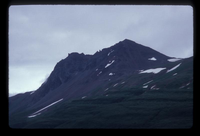
This feature is part of the Savonoski River Cluster of volcanoes, as defined by Hildreth and others (2004) [1] . From Hildreth and others (2004) [1] : "Rainbow River Cone (Peak 3980) is a small basaltic volcano (51.8-53% SiO2) perched on a basement ridge east of Rainbow River, 15 km NW of Mount Denison. The glacially sculpted cone, 1 km wide with 330 m relief, consists of radially dipping stacks of thin lavas and breccia sheets intercalated with scoria falls, well exposed on bounding cliffs, cut by numerous dikes, and gutted by a northerly cirque. Lavas and ejecta contain phenocrysts of plagioclase, orthopyroxene, clinopyroxene, olivine, and Fe-Ti oxides. An ice-scoured lava plateau (390 +/- 39 ka) extends 1 km SE from the cone."Name Origin
"Rainbow River cone" is an informal name, after the nearby Rainbow River given by Hildreth and others (2004). The Rainbow River was named by R.H. Sargent's party in 1923 "because six rainbows were seen there" (Orth, 1971).
References Cited
[1] Rear-arc vs. arc-front volcanoes in the Katmai reach of the Alaska Peninsula: a critical apprasial of across-arc compositional variation, 2004
Hildreth, Wes, Fierstein, Judy, Siems, D. F., Budahn, J. R., and Ruiz, Joaquin, 2004, Rear-arc vs. arc-front volcanoes in the Katmai reach of the Alaska Peninsula: a critical apprasial of across-arc compositional variation: Contributions to Mineralogy and Petrology, v. 147, n. 3, p. 243-275.Reported Activity
Modern Eruptions
1 Event Date(s)
Past Activity Legend:
| Eruption | |
| Questionable eruption | |
| Non-eruptive activity |


Showing 1 - 4 of 4
Map Images
By:
U.S. Geological Survey
Topographic shaded relief map depicting the locations of Iron Trig cone, Knob 1000, Cone 3601, and Rainbow River cone, Alaska.
Topographic shaded relief map depicting the locations of Iron Trig cone, Knob 1000, Cone 3601, and Rainbow River cone, Alaska.
By:
Schaefer, J. R. G.
Alaska Peninsula volcanoes.
Alaska Peninsula volcanoes.
By:
Schaefer, Janet
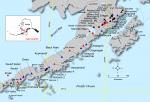
Index map showing the location of Quaternary volcanoes on the Alaska peninsula.
Index map showing the location of Quaternary volcanoes on the Alaska peninsula.
Map References
References
Preliminary database of Quaternary vents in Alaska, 2014
Cameron, C.E., and Nye, C.J., 2014, Preliminary database of Quaternary vents in Alaska: Alaska Division of Geological & Geophysical Surveys Miscellaneous Publication 153, 11 p., doi:10.14509/27357 .
Rear-arc vs. arc-front volcanoes in the Katmai reach of the Alaska Peninsula: a critical apprasial of across-arc compositional variation, 2004
Hildreth, Wes, Fierstein, Judy, Siems, D. F., Budahn, J. R., and Ruiz, Joaquin, 2004, Rear-arc vs. arc-front volcanoes in the Katmai reach of the Alaska Peninsula: a critical apprasial of across-arc compositional variation: Contributions to Mineralogy and Petrology, v. 147, n. 3, p. 243-275.
Mesozoic macrofossil locality map, checklists, and pre-Quaternary stratigraphic section of the Mt. Katmai and adjacent parts of the Afognak and Naknek quadrangles, Alaska Peninsula, Alaska, 1995
Miller, J.W., Elder, W.P., and Detterman, R.L., 1995, Mesozoic macrofossil locality map, checklists, and pre-Quaternary stratigraphic section of the Mt. Katmai and adjacent parts of the Afognak and Naknek quadrangles, Alaska Peninsula, Alaska: U.S. Geological Survey Miscellaneous Field Studies Map 2021-G, 3 sheets. https://doi.org/10.3133/mf2021G
Before an eruption
Ashfall & Preparedness Information
- ASH FALL ALERTS
- Ash Alert! Pamphlet
- USGS Ashfall Preparedness website
- Alaska Department of Environmental Conservation, Division of Air Quality - Volcanic Ashfall
- Alaska Department of Health - Volcanic Eruptions, Health Effects
- Citizen Science: Ashfall collection instructions
- Citizen Science: IS ASH FALLING? Report your observations (yes or no!)