Tlevak Strait
Spurr
Great Sitkin
Legend
✕
| Red (Warning) | |
| Orange (Watch) | |
| Yellow (Advisory) | |
| Green (Normal) | |
| Uninstrumented | |
| Community | |
| Webcam | |
| Instrument | |
| Earthquake Magnitude | |
|
0
| |
| Earthquake Age | |
| Last 2 Hours | |
| Last 2 Days | |
| Last 1 Week | |
Facts
- Seismically Monitored: No
- Color Code: UNASSIGNED
- Alert Level: UNASSIGNED
- Elevation: 50m (164ft)
- Latitude: 55.2496
- Longitude: -133.302
- Smithsonian VNum: 315060
-
Nearby Towns:
- Craig 17 mi (27 km) NE
- Hydaburg 19 mi (30 km) SE
- Klawock 22 mi (36 km) NE
- Hollis 30 mi (48 km) NE
- Kasaan 41 mi (65 km) NE
Distance from Anchorage: 728 mi (1172 km)
-
Subfeatures:
- Arena Cove
Description
From Wood and Kienle (1990) [1] : "Flat-lying sodic alkalic olivine basalt flows with fresh pahoehoe surfaces occur in the vicinity of Tlevak Strait west of Prince of Wales Island, at Trocadero Bay on Suemez Island, and in valleys on northern Dall Island. The outcrop areas are indicated by Qb on the map [2] ."Name Origin
"Tlevak Strait", as applied to the group of volcanic vents near Tlevak Strait waterway, is an informal name.
References Cited
[1] Volcanoes of North America: United States and Canada, 1990
Wood, C. A., and Kienle, Juergen, (eds.), 1990, Volcanoes of North America: United States and Canada: New York, Cambridge University Press, 354 p.[2] Geology of the Craig Quadrangle, Alaska, 1983
Eberlein, G.D., Churkin, Michael Jr., Carter, Claire, Berg, H.C., and Ovenshine, A.T., 1983, Geology of the Craig Quadrangle, Alaska: U.S. Geological Survey Open-File Report 83-91, 52 p., 4 sheets, scale 1:250,000, available online at http://www.dggs.alaska.gov/pubs/id/11508 .Reported Activity
Modern Eruptions
0 Event Date(s)
Past Activity Legend:
| Eruption | |
| Questionable eruption | |
| Non-eruptive activity |

Showing 1 - 2 of 2
Map Images
By:
U.S. Geological Survey
Topographic shaded relief map of the Tlevak Strait - Suemez Island area.
Topographic shaded relief map of the Tlevak Strait - Suemez Island area.
By:
Schaefer, J. R. G.
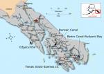
"Index map showing locations of volcanoes in Southeast Alaska."
"Index map showing locations of volcanoes in Southeast Alaska."
Map References
Map showing distribution, composition, and age of Late Cenozoic volcanic centers in Alaska, 1986
Luedke, R. G., and Smith, R. L., 1986, Map showing distribution, composition, and age of Late Cenozoic volcanic centers in Alaska: U.S. Geological Survey Miscellaneous Investigations Series Map I 1091-F, unpaged, 3 sheets, scale 1:1,000,000.
Geology of the Craig Quadrangle, Alaska, 1983
Eberlein, G.D., Churkin, Michael Jr., Carter, Claire, Berg, H.C., and Ovenshine, A.T., 1983, Geology of the Craig Quadrangle, Alaska: U.S. Geological Survey Open-File Report 83-91, 52 p., 4 sheets, scale 1:250,000, available online at http://www.dggs.alaska.gov/pubs/id/11508 .
References
Geologic database of information on volcanoes in Alaska (GeoDIVA), 2022
Cameron, C.E., Crass, S.W., and AVO Staff, eds, 2022, Geologic database of information on volcanoes in Alaska (GeoDIVA): Alaska Division of Geologic and Geophysical Surveys Digital Data Series 20, https://doi.org/10.14509/geodiva, https://doi.org/10.14509/30901.
2018 update to the U.S. Geological Survey national volcanic threat assessment, 2018
Ewert, J.W., Diefenbach, A.K., and Ramsey, D.W., 2018, 2018 update to the U.S. Geological Survey national volcanic threat assessment: U.S. Geological Survey Scientific Investigations Report 2018-5140, 40 p., https://pubs.usgs.gov/sir/2018/5140/sir20185140.pdf.
Alaska Volcano Observatory image database, 2016
Cameron, C.E., and Snedigar, S.F., 2016, Alaska Volcano Observatory image database: Alaska Division of Geological & Geophysical Surveys Digital Data Series 13, https://www.avo.alaska.edu/images/. https://doi.org/10.14509/29689.
Preliminary database of Quaternary vents in Alaska, 2014
Cameron, C.E., and Nye, C.J., 2014, Preliminary database of Quaternary vents in Alaska: Alaska Division of Geological & Geophysical Surveys Miscellaneous Publication 153, 11 p., doi:10.14509/27357 .
Preliminary spreadsheet of eruption source parameters for volcanoes of the world, 2009
Mastin, L.G., Guffanti, Marianne, Ewert, J.E., and Spiegel, Jessica, 2009, Preliminary spreadsheet of eruption source parameters for volcanoes of the world: U.S. Geological Survey Open-File Report 2009-1133, v. 1.2, 25 p., available at http://pubs.usgs.gov/of/2009/1133/ .
System for ranking relative threats of U.S. volcanoes, 2007
Ewert, John, 2007, System for ranking relative threats of U.S. volcanoes: Natural Hazards Review, v. 8, n. 4, p. 112-124.

Volcanoes of the world: an illustrated catalog of Holocene volcanoes and their eruptions, 2003
Siebert, L., and Simkin, T., 2002-, Volcanoes of the world: an illustrated catalog of Holocene volcanoes and their eruptions: Smithsonian Institution, Global Volcanism Program Digital Information Series GVP-3, http://volcano.si.edu/search_volcano.cfm, unpaged internet resource.
Bibliography of information on Alaska volcanoes, 2003
Cameron, C. E., Triplehorn, J. H., and Robar, C. L., 2003, Bibliography of information on Alaska volcanoes: Alaska Division of Geological & Geophysical Surveys Miscellaneous Publication MP 131, 1 CD-ROM.
Hard Copy held by AVO at FBKS - CEC file cabinet
Volcanoes of the world [2nd edition], 1994
Simkin, Tom, and Siebert, Lee, 1994, Volcanoes of the world [2nd edition]: Tucson, Arizona, Geoscience Press, 349 p.
Hard Copy held by AVO at FBKS - CEC shelf
Volcanoes of North America: United States and Canada, 1990
Wood, C. A., and Kienle, Juergen, (eds.), 1990, Volcanoes of North America: United States and Canada: New York, Cambridge University Press, 354 p.
Hard Copy held by AVO at FBKS - CEC shelf
Map showing distribution, composition, and age of Late Cenozoic volcanic centers in Alaska, 1986
Luedke, R. G., and Smith, R. L., 1986, Map showing distribution, composition, and age of Late Cenozoic volcanic centers in Alaska: U.S. Geological Survey Miscellaneous Investigations Series Map I 1091-F, unpaged, 3 sheets, scale 1:1,000,000.
Geology of the Craig Quadrangle, Alaska, 1983
Eberlein, G.D., Churkin, Michael Jr., Carter, Claire, Berg, H.C., and Ovenshine, A.T., 1983, Geology of the Craig Quadrangle, Alaska: U.S. Geological Survey Open-File Report 83-91, 52 p., 4 sheets, scale 1:250,000, available online at http://www.dggs.alaska.gov/pubs/id/11508 .
Tlevak basalt, west coast of Prince of Wales Island, southeastern Alaska, 1970
Eberlein, G. D., and Churkin, M. J., 1970, Tlevak basalt, west coast of Prince of Wales Island, southeastern Alaska: in Cohee, G. V., Bates, R. G., and Wright, W. B., (eds.), Changes in stratigraphic nomenclature by the U.S. Geological Survey, 1968, U.S. Geological Survey Bulletin 1294-A, p. A25-A28.
Before an eruption
Ashfall & Preparedness Information
- Ashfall impacts & preparedness (US Geological Survey)
- Volcanic health hazards & impacts (International Volcanic Health Hazards Network)
- Ash Alert! Pamphlet (AK Division of Homeland Security & Emergency Management)
- Volcanic Ashfall (AK Department of Environmental Conservation, Division of Air Quality)