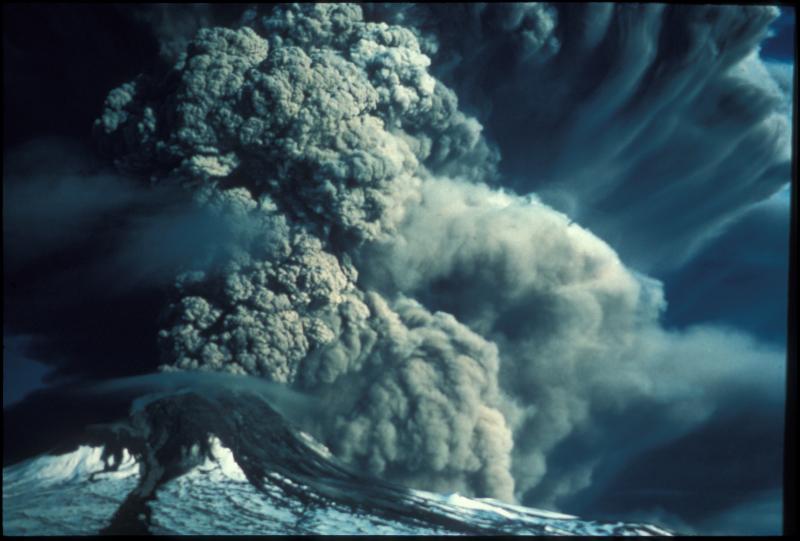
Augustine volcano in eruption, 1976.
Volcano(es): Augustine
Photographer: Kienle, Juergen
URL: avo.alaska.edu/image/view/9646
Credit: Image courtesy of the AVO/UAF-GI.
Use Restriction: Please cite the photographer and the Alaska Volcano Observatory / University of Alaska Fairbanks, Geophysical Institute when using this image.
Full Resolution.
Augustine 1976/1
From Shackelford (1978): "In the morning of 22 January Augustine began a period of major activity from a new vent located at the contact of the 1935 and 1964 domes. The first major eruption began at 0740 AST on 23 January. On that date there were at least 8 major eruptions, one was at 1618 AST. An additional 4 major explosive outbreaks took place on 24-25 January. The eruption clouds pierced the tropopause, reaching heights + 10,000 m to 14,000 m a.s.l. Ash falls took place at Iliamna, Homer, Seldovia, and Anchorage (1.5mm). The January eruptions explosively removed most of the summit 1964 dome, forming a crater breached to the N.
"* * * The explosive activity was accompanied by major pyroclastic flows, and mudflows and lahars. The January glowing avalanches spread radially over the island, reaching the sea on the S, NE, and NW flanks. The Burr Point Research Station (NW tip of island) was severely damaged by one or more avalanches, although protected by a ridge, as a result of a back eddy in the clouds. Several days afterwards, temperatures in the pyroclastic flow deposit exceeded 400 degrees C at a depth of 2.7 (deposit is on the NE slope). There was an active fumarole field at the distal end of the deposit. Augustine was relatively quiet from 26 January to 5 February.
"The second cycle of eruptions began with the renewal of major activity at 0443 on 6 February, resulting in falls of ash and mud along the Kenai Peninsula. A strong eruption at 1230 on the 6th produced a cloud that rose to a height of 8-9 km. A blizzard-like ash fall at Homer on the 6th was the heaviest of the entire eruption, prohibiting vehicular traffic because of the induced darkness at 1800. Eruptions generally ended on the 15th, producing eruption plumes that usually rose to heights of 3-4, 5 km. Again, there was production of major pyroclastic flows which followed the same paths as those of January. The January flows had formed a new beach on the NE part of the island, and a further extension of this beach resulted from the glowing avalanches of February * * * Activity on the 16th consisted of occasional steam explosions. On the 18th there were a few ash-laden puffs rising from Augustine. Observations on that date showed that a new tholoid had formed in the new crater, probably on the 12th and 13th which was a period of continuous harmonic tremor. The new dome was found to be about 260 m above its base. From 19 February to April another quiet period ensued, although there were some block and ash flows off of the new dome beginning in late February. There was some earthquake swarm activity on 15 to 25 March.
"The third and last cycle took place in April. In the early part of the month explosion earthquakes began to be recorded on the new seismic array. The number of eruptions as follows: 6-12 eruptions per day during 6-9 April, 1 eruption per hour on 10-11 April, almost continuous intense eruptions during 12-18 April, 12 eruptions per day on 18-22 April. Eruptive behavior returned to low levels on the 23rd. Since 24 April there have been no further eruptions, just quiet degassing from the new dome, with some spectacular plumes reported. The April explosive activity was accompanied by block and ash flows shed off the new dome, which underwent a period of renewed growth in April."
David Johnston (1978) calculates that "roughly 0.17 cubic km of rock was erupted in 1976, of which about 27% was erupted in January, 59% in February, and 14% in April. Fifty-three percent of the volume is in pyroclastic flow deposits, 38% in the lava dome, and 8% in ash-fall and pyroclastic surge deposits. Ejecta erupted in January include approximately 10% andesite scoria, 50% dacite pumice, and 40% hybrid and banded pumices."
Kienle and Swanson (1985) have slightly different volume estimates for this eruption: "* * * the estimated bulk volume of the ejecta from the 1976 eruption is about 0.4 cubic km, of which 0.06 cubic km are flows on the island itself and the rest [0.339 cubic km] is tephra. We arrived at this estimate by digitizing the the pre- and post-eruption topography of the sector most affected by debris flow activity, the northeast sector of the Island (see Figure 31 in original text) and by using conservative estimates of the total thickness of tephra accumulation for the area that was affected by ash falls (See Figure 15 in original text)."