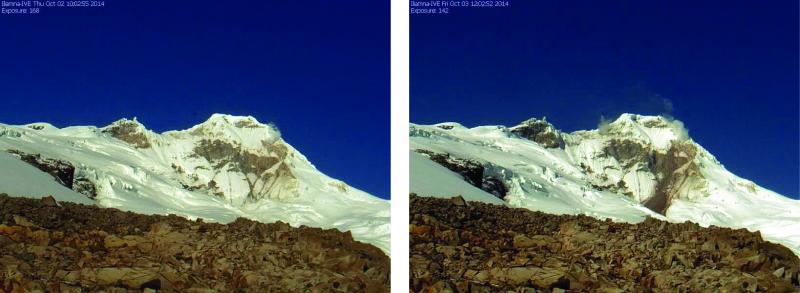
Before and after images of a small rockfall/landslide on Iliamna, captured on IVE's webcam. Left image: view from IVE on October 2, pre-rockfall. Right image: view from IVE on October 3, after the rockfall. The debris ran about 2 km down the upper Red Glacier. The slide happened early UTC on Oct 3 2014.
Volcano(es): Iliamna
Photographer: Kaufman, Max
URL: avo.alaska.edu/image/view/77461
Credit: Image courtesy of the AVO/UAF-GI.
Use Restriction: Please cite the photographer and the Alaska Volcano Observatory / University of Alaska Fairbanks, Geophysical Institute when using this image.
Full Resolution.
Iliamna 2014/1
From Cameron and others, 2017: "Iliamna Volcano during 2014 experienced several significant rock/snow/ice avalanches on its eastern flank, and numerous smaller avalanches. Seismic data indicated a likely avalanche at 12:11 UTC (3:11 a.m. AKST) on January 28. This event was identified primarily by its characteristic seismicity - precursory seismicity of small, discrete events transitioning into a continuous signal consistent with a slide (Scott Stihler, UAFGI/AVO, written commun., 2014). In mid-May, satellite imagery of Iliamna showed recent avalanche deposits extending about 1.5 km (0.93 mi) eastward from a near-summit source area (Christina Neal, USGS/AVO, written commun., 2014) that may have been the source of the seismic signal 4 months earlier.
"AVO conducted its annual overflight of Iliamna to measure gas concentrations on April 10, recording normal background levels of about 32 tons/d of SO2. Because of an instrument malfunction, CO2 was not measured on this flight (Cynthia Werner, USGS/AVO, written commun., 2015). Iliamna remained at Aviation Color Code and Volcano Alert Level GREEN/NORMAL throughout 2014.
"On July 20, AVO received a phone call from a citizen on the Kenai Peninsula reporting a new avalanche at Iliamna, identified by the presence of new dark streaks within the snowfield. A review of the seismic data showed that the avalanche likely occurred at about 16:00 UTC (8:00 a.m. AKDT) on July 20. The deposit extended about 2.8 km (1.7 mi) east from the summit (Rick Wessels, USGS/AVO, written commun., 2014).
"Satellite imagery from August 19 documented new fresh avalanches at Iliamna, slightly larger than those in July. In early October, AVO observed evidence for a small, recent landslide or avalanche on the upper headwall of the Red Glacier on the eastern side of Iliamna. A retrospective analysis of the seismic data showed that the avalanche likely occurred in the early morning of October 3 (Jacqueline Caplan-Auerbach, Western Washington University, written commun., 2014). This new avalanche extended about 2 km (1.2 mi) from its source area."