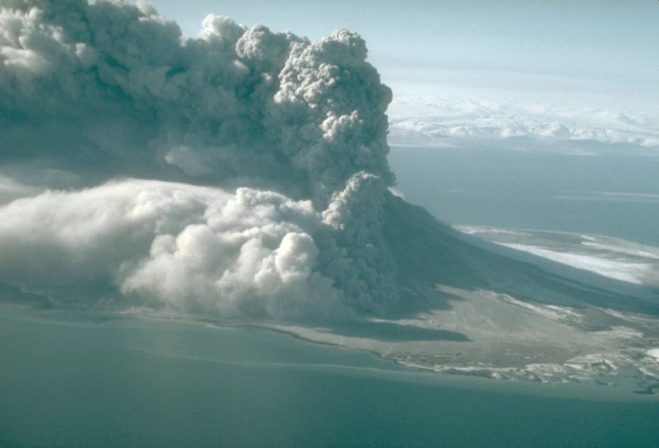
A pyroclastic flow sweeping down the north flank of 1,282-m (4,206 ft)-high Augustine Volcano. The eruption cloud is carried to the east by prevailing winds. Photograph by M.E. Yount, U.S. Geological Survey, March 30, 1986.
Volcano(es): Augustine
Photographer: Yount, M. E.
URL: avo.alaska.edu/image/view/402
Credit: Image courtesy of AVO / U.S. Geological Survey.
Use Restriction: Please cite the photographer and the Alaska Volcano Observatory/U.S. Geological Survey when using this image.
Full Resolution.
Augustine 1986/3
From Swanson and Kienle (1988): "Precursory seismic activity was first detected in July 1985, 8 months prior to the 1986 eruption. A sharp increase in seismicity in March 1986 led to speculation about a possible eruption (Kienle, 1986). A several-order-of-magnitude increase in seismic event counts on the morning of March 26 heralded the eruption that began on the morning of March 27. A short-term forecast of the eruption was made on the afternoon of March 26 (Kienle and others, 1986).
"The initial phase of the eruption involved explosive removal of a portion of the 1976 dome and formed a small (about 100 m in diameter) vent on the southwest flank of the dome (Miller and others, 1987; Yount and Miller, 1987). Numerous pyroclastic flows were observed during the 103 hours of this first eruptive phase, and eruption columns reached heights in excess of 12,000 m (Yount and others, 1987). Pyroclastic flows were directed through the breach in the north side of the crater and spread out on the lower flanks of the volcano. Some of these pyroclastic flows reached the sea to the west and east of Burr Point, and ash cloud surges continued for some distance offshore.
"Prevailing winds on March 27 and 28 were from the southwest and spread ash throughout Cook Inlet. Later on March 28, the winds shifted to the west and finally to the north on March 30 and 31. Ash was thus scattered over populated areas in Cook Inlet only during the early stages of the eruption, but the dust lingered in the air over Cook Inlet, including Anchorage, until March 31.
"Lava was extruded during the second eruptive phase from April 23 to 28. A short blocky lava flow issued from the base of the 1976 dome remnant. Pyroclastic flows descended from the growing dome, but none of them reached the sea.
"* * * A period of accelerated dome growth between August 30 and 31, 1986, resulted in an increase of pyroclastic flow activity. Flows moved down the north flank of the volcano for distances up to 2.2 km from the source (Kienle, 1986). Eruption clouds rose 1000 to 2000 m above the volcano during this episode. None of the pyroclastic flows reached the sea.
"High-silica, two-pyroxene andesite, similar to that produced in previous Mount St. Augustine eruptions was also erupted in 1986 (Swanson and others, 1986; Harris and others, 1987). Groundmass glass in the 1986 andesites is rhyolitic in composition, as in past eruptions, and this is one factor in the explosive character of the eruption. Distribution of eruptive products and volumes of material erupted in 1986 was also similar to other historic eruptions.
"Pyroclastic flow deposits were restricted to the north flank of the volcano, the result of funneling through the breach in the north side of the crater. Lahars composed of reworked air fall deposits form a circular pattern around the upper part of the cone. On the south flank, lahars descended to about 300 m above sea level.
"The new dome occupies the central part of the volcano and a small lava flow extends just a few hundred meters from the dome. A new 50-m-high spine was extruded during the August phase of renewed dome growth. Since then, a large section of the 1986 dome has collapsed and has formed a debris avalanche deposit on the upper northern slope of the volcano.
"Incandescent vents were discovered on August 28, 1987, at the southern base of the spine, with maximum fumarole temperature of 88 degrees C (R. Symonds, personal communication, 1987).
"A new topographic map of Augustine Island was prepared by North Pacific Aerial Surveys for the U.S. Geological Survey from aerial photography taken on September 9, 1986, using geodetic control points surveyed by University of Alaska and U.S. Geological Survey personnel on June 6, 1986 (J. Power, personal communication, 1986). The map shows that the 1986 dome had reached a height of 1252 m by September 9, 1986. Thus the dome gained about 26 m in elevation between 1976 and 1986. The highest point of the volcano is the south peak, which remained unchanged at 1252 m. More changes in dome height could have occurred since then, but the dome has not yet been resurveyed. The total expanded volume of the 1986 pyroclastic flow deposits on Augustine Island is estimated to be close to the 1976 pyroclastic flow volume of about 0.05 cubic km, but could be a little larger."
The April edition of the Scientific Event Alert Network Bulletin (v. 11, n. 04) gives an inflated material estimate of 0.11 cubic km for the March 31 pyroclastic flow, and an estimate volume for the dome (as of May 6) of 0.06 cubic km.