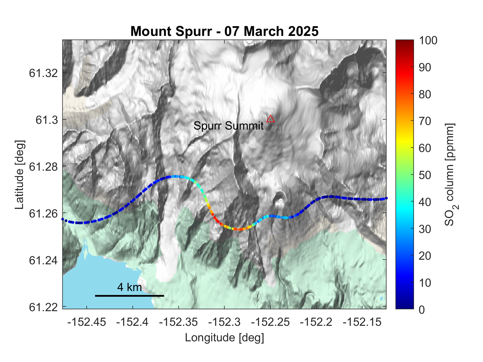
Map showing the flight track of an airborne traverse beneath the gas plume emitting from Mount Spurr on March 7, 2025. The colors indicate the total amount of sulfur dioxide above the aircraft as measured using an upward looking spectrometer. Further analysis of the data yielded a sulfur dioxide emission rate of about 440 tons per day. Basemap: Google
Volcano(es):
Photographer: Kern, Christoph
URL: avo.alaska.edu/image/view/196412
Spurr unrest 2024
On October 16, 2024, AVO raised the color code and alert level to YELLOW/ADVISORY, stating: "AVO has observed a gradual increase in volcanic unrest over a period of several months at Mount Spurr, located about 120 km (75 miles) west of Anchorage (https://avo.alaska.edu/image/view/196123). GNSS receivers have detected sustained upward and outward ground deformation since March 2024. An increase in seismic activity has also been noted since April (https://avo.alaska.edu/image/view/196122). Other indications of elevated activity include the development of a small lake in the summit crater in early summer of 2024.
"The largest magnitude earthquake detected in this current period of unrest is a M2.3 earthquake on October 6th. This increase in activity was described in detail in an Information Statement (https://avo.alaska.edu/news/hans/DOI-USGS-AVO-2024-10-09T19:43:26+00:00) that AVO released on October 9th. Analysis of seismic data indicates a subtle increase in the rate and size of earthquakes over the past few weeks. Because this is a notable departure from the normal background seismicity of the volcano, AVO is raising the Aviation Color Code to YELLOW and the Volcano Alert Level to ADVISORY. However, there are no indications that an eruption is imminent. Often this type of seismicity and ground deformation will decline without producing an eruption.
"AVO continues to closely monitor activity at Mount Spurr for signals that would indicate that the volcano is moving closer to an eruption. Based on previous eruptions, changes from current activity in the earthquakes, ground deformation, summit lake, and fumaroles would be expected if magma began to move closer to the surface. Therefore, it is very likely that if an eruption were to occur it would be preceded by additional signals that would allow advance warning. "
Over the following two weeks, there were more than 180 small earthquakes at Mount Spurr. Over the week of November 1st, there were also a few episodes of possible volcanic tremor, which might indicate deep fluid movement. No unusual activity or surface changes were observed in satellite data or webcam views. AVO staff visited on October 24th to conduct pre-winter maintenance on Spurr’s monitoring network and noted that the fumaroles (steam/gas vents) in Spurr summit’s crater were steaming.
Over the following weeks, earthquakes continued at varying rates, as is typical during periods of unrest. Steam was occasionally visible rising from Spurr’s summit during clear weather. On December 10, there was a M2.8 earthquake beneath the summit, and a few more episodes of tremor were recorded that week.
On Wednesday, December 18, AVO staff conducted a gas flight at Mount Spurr. Measurements of H2O, SO2, H2S, and CO2 were collected. Results were similar to the previous gas flight conducted on June 23, 2024. Personnel also took images and video during the flight that allowed accurate measurements of the crater lake that formed this year, showing that it has grown considerably since June despite the transition into winter. No activity was observed at Crater Peak.
As the new year turned, there were some notable periods of increased earthquake activity within the context of the larger unrest episode. The week of January 3, 2025, over 260 earthquakes were located, the largest being an M2.9 on January 2. Meanwhile, GPS data continued to show slow, steady inflation of the ground surface. Satellite radar data the week of January 10 showed that the crevasses in the summit crater were widening, demonstrating continued heat input to the area.
During late January, the monitoring network at Mount Spurr experienced some issues transmitting data back to AVO due to poor weather, not unusual for this time of year.
On January 31, AVO reported that over the past few weeks more of the ongoing earthquakes had clustered under Crater Peak, the vent that produced the 1953 and 1992 eruptions.
On February 6, AVO released an Information Statement detailing the activity since the color code change in October. The statement noted that over 2700 earthquakes had been detected to date during the period of unrest, which as of this date was ten months long. Movement of the ground surface near the area of Spurr was now about 2.4 inches total, as measured at the closest monitoring station to the mountain. Based on the earthquakes, deformation, growth of the lake in the Spurr summit crater, and low levels of volcanic gases measured, AVO rated the odds of no eruption and a future eruption at the Crater Peak vent as equally likely, with an eruption from Spurr summit less likely. However, additional signs of unrest would be expected in the lead up to an eruption.
On February 7, AVO staff visited the Spurr monitoring network to clear snow and ice from the instruments. They also collected additional volcanic gas measurements which showed no significant changes since the previous gas flight in December.
The remaining weeks of February followed the same general trends, with earthquake rates varying quite a bit while other signs of unrest-deformation and occasional steaming from the summit-remaining consistent. Fewer earthquakes were located close to Crater Peak.
On March 7 and March 11, AVO conducted flights to once again measure any volcanic gases emitted by Spurr. These flights, while consistent with one another, yielded considerably altered results from the previous flights. Elevated levels of sulfur dioxide and carbon dioxide were measured at Spurr summit, while very high levels of carbon dioxide were measured at Crater Peak. Staff also observed newly reactivated fumaroles within Crater Peak. These new changes led AVO to release an Information Statement on March 12 stating that likelihood of an eruption had increased and that AVO considered an eruption similar to 1953 and 1992 at Crater Peak to be the most likely outcome of the current unrest episode.
On March 17, AVO staff visited the Spurr monitoring network to conduct maintenance and clear the snow and ice from the CKT webcam.
Use Restriction: Please cite the photographer and the Alaska Volcano Observatory / U.S. Geological Survey when using this image. Basemap: Google
Full Resolution.