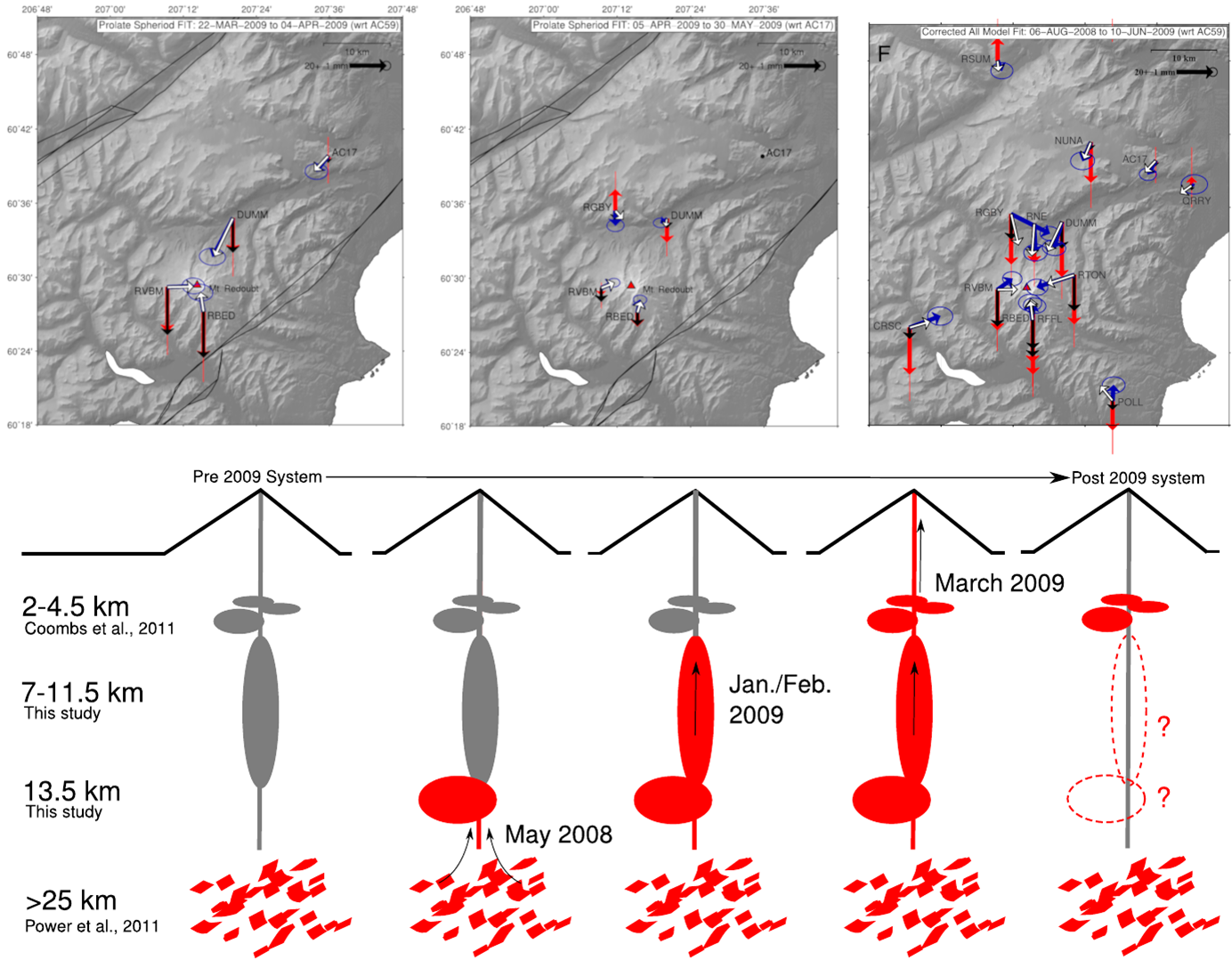
The top panels show the deformation recorded during the explosive phase of the 2009 eruption of Redoubt Volcano (left), the effusive phase at the tail end of the eruption (middle) and the total deformation between summer 2008 to summer 2009 (right), from before to after the eruption. The red and blue arrows are vertical (red) and horizontal (blue) motion of each GPS station. The white (horizontal) and black (vertical) arrows show the motion we would expect to see at these stations if magma was removed from the magmatic system below the volcano. From these data and how they change over time, we can come up with a model, shown in the bottom panel, of magma migrating through the system. Figure adapted from Grapenthin and others, 2013.
Volcano(es): Redoubt
Photographer: Grapenthin, Ronni
URL: avo.alaska.edu/image/view/194552
Credit: Image courtesy of the AVO/UAF-GI.
Use Restriction: Please cite the photographer and the Alaska Volcano Observatory / University of Alaska Fairbanks, Geophysical Institute when using this image.
Full Resolution.
Redoubt 2009/3
From Schaefer (ed), 2012: "Redoubt Volcano, an ice-covered stratovolcano on the west side of Cook Inlet, erupted in March 2009 after several months of escalating unrest. The 2009 eruption of Redoubt Volcano shares many similarities with eruptions documented most recently at Redoubt in 1966-68 and 1989-90. In each case, the eruptive phase lasted several months, consisted of multiple ash-producing explosions, produced andesitic lava and tephra, removed significant amounts of ice from the summit crater and Drift glacier, generated lahars that inundated the Drift River valley, and culminated with the extrusion of a lava dome in the summit crater. Prior to the 2009 explosive phase of the eruption, precursory seismicity lasted approximately six months with the first weak tremor recorded on September 23, 2008. The first phreatic explosion was recorded on March 15, and the first magmatic explosion occurred seven days later, at 22:34 on March 22. The onset of magmatic explosions was preceded by a strong, shallow swarm of repetitive earthquakes that began about 04:00 on March 20, 2009, less than three days before an explosion. Nineteen major ash-producing explosions generated ash clouds that reached heights between 17,000 ft and 62,000 ft (5.2 and 18.9 km) ASL. During ash fall in Anchorage, the Ted Stevens International Airport was shut down for 20 hours, from ~17:00 on March 28 until 13:00 on March 29. On March 23 and April 4, lahars with flow depths to 10 m in the upper Drift River valley inundated parts of the Drift River Terminal (DRT). The explosive phase ended on April 4 with a dome collapse at 05:58. The April 4 ash cloud reached 50,000 ft (15.2 km) and moved swiftly to the southeast, depositing up to 2 mm of ash fall in Homer, Anchor Point, and Seldovia. At least two and possibly three lava domes grew and were destroyed by explosions prior to the final lava dome extrusion that began after the April 4 event. The final lava dome ceased growth by July 1, 2009, with an estimated volume of 72 Mm3."
Wallace and others (2012) calcuate a total Dense Rock Equivalent of about 0.02 cubic meters for tephra fall from the Redoubt 2009 eruption.