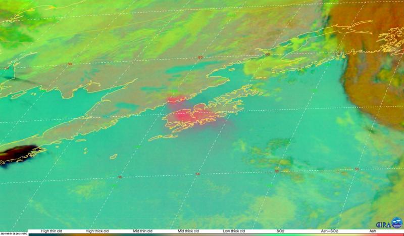
GOES-17 satellite imagery showing resuspended ash (salmon pink cloud drifting southeast from the Alaska Peninsula over Kodiak Island and the Pacific Ocean) from the 1912 Novarupta-Katmai eruption. Satellite image acquired from the data service provided by the Cooperative Institute for Research in the Atmosphere at Colorado State University.
Volcano(es): Katmai Novarupta
Photographer: Schneider, David
URL: avo.alaska.edu/image/view/177701
Credit: Image courtesy of AVO/USGS.
Use Restriction: Please cite the photographer and the Alaska Volcano Observatory / U.S. Geological Survey when using this image.
Full Resolution.
Novarupta ash resuspension 2021
From Orr and others, 2024: "On August 28, 2021, strong winds picked up loose volcanic ash from the Mount Katmai (Novarupta) region and carried it southeastward toward Kodiak Island. The National Weather Service (NWS) had forecasted this event a few days prior, and when it occurred, the NWS Alaska Aviation Weather Unit (AAWU) reported cloud heights as much as ~6,000 ft (~1,800 m) ASL, issuing a significant meteorological information statement (SIGMET) for aviators. AVO also issued an Information Statement.
"The following month, strong winds again generated a cloud of resuspended ash that drifted over Kodiak Island. This event, like the one a month prior, was anticipated by the NWS a few days in advance. The drifting ash cloud appeared clearly in satellite data for ~24 hours, starting in the afternoon of September 20. AAWU issued a SIGMET reporting ash at altitudes as high as ~8,000 ft (~2,400 m) ASL; AVO correspondingly issued an Information Statement. Trace ash fall was reported in the City of Kodiak, Alaska, and owing to the forecast of this event, a local observer was able to sample the ash fall and send it to AVO.
"The ash resuspension had ceased for only two days when, beginning late in the afternoon on September 23, winds again picked up loose ash. This ash cloud drifted east across northern Kodiak Island at an apparently lower altitude (~5,000 ft [~1,500 m] ASL), though no ashfall was reported. This resuspension event also lasted ~24 hours, during which time AAWU issued a SIGMET and AVO issued an Information Statement.
"AVO observed the next minor cloud of resuspended ash in satellite views on September 26. This cloud drifted southeastward toward the middle of Shelikof Strait, never reaching Kodiak Island. No Information Statements were issued for this minor event.
"Before dawn on October 2, strong winds near Mount Katmai once again picked up loose volcanic ash and carried it southeastward toward Kodiak Island. As with most previous resuspension events at Mount Katmai in 2021, the NWS had forecasted the event a few days prior. AAWU issued a SIGMET and the NWS Forecast Office issued a Marine Weather Statement. AVO issued an Information Statement reporting ash clouds that reached altitudes of ~6,000 ft (~1,800 m) ASL. Meteorological clouds obscured satellite observations the next day, but the SIGMET remained in place for ~24 hours owing to the likelihood of continued ash resuspension.
"Starting on the morning of November 17, another cloud of resuspended ash appeared clearly in satellite data. Most of the typical source region for resuspended ash at Mount Katmai was covered in snow at the time, so this event’s ash source was apparently confined to valleys on the north side of Shelikof Strait, in the vicinity of Mount Katmai. AAWU issued a SIGMET reporting a cloud altitude as high as ~7,000 ft (~2,100 m) ASL; AVO correspondingly issued an Information Statement. Resuspended ash was visible in satellite data until about midnight, although reports of resuspended ash from the City of Kodiak continued into the following day. Residents in Kodiak collected trace ashfall.
"The last resuspension event in the Mount Katmai region in 2021 occurred on November 25. AAWU issued a SIGMET reporting a cloud that drifted over Kodiak Island at an altitude as high as ~5,000 ft (~1,500 m) ASL. The NWS Forecast Office issued a Marine Weather Statement and AVO issued an Information Statement."