Bogoslof 1907/1
Start: January 1907 ± 3 Months [1]
Stop: September 1, 1907 [1]
Event Type: Explosive
Max VEI: 3 [2]
Description: The Smithsonian Volcanoes of the World book and Global Volcanism Program online database considers the time period between March, 1906, and September, 1907, to be one eruption at Bogoslof. However, the GeoDIVA database considers the formation and destruction of Metcalf Cone (March, 1906-January, 1907) one eruption, and the formation and destruction of McCulloch Peak (January 1907-September 1907) is treated as a separate eruption.
Miller and others (1998) summarizes this eruption, which began in early 1907, as follows: "[A]nother dome emerged, joining Metcalf Cone and Old Bogoslof (Byers, 1959). This dome, McCulloch Peak, was subsequently obliterated in a violent explosion on September 1, 1907 that showered Unalaska Village with 0.5 cm of ash and mantled the remaining Bogoslof Islands with debris." The Perry likely saw McCulloch Peak on June 21, 1907, as they recorded in their logbook "Some unfamiliar pinnacle rocks between Castle and Perry Islands" (see logbook entry on Old Weather website: http://oldweather.s3.amazonaws.com/ow3/final/Commodore%20perry//Volumes/Seagate%20Backup%20Plus%20Drive/Arfon-JPEGS/RG26/COMMODORE%20PERRY//vol184/vol184_175_1.jpg.
Jaggar (1908) reports: "In the spring of 1907 Captain Dirks, a local trader, brought word that a still newer peak had risen beside Metcalf Cone. The Cutter McCulloch visited the scene in July, 1907, and reported that this was indeed true, and moreover, Metcalf Cone had half collapsed, and the channel between it and Castle Rock was filled up with the new steaming heap, "McCulloch Peak," and a wide stretch of gravel wash. Such was substantially the state of affairs when the Technology Expedition arrived August 7, 1907. A day was spent in exploring, photographing, and collecting specimens. The landing was made in dories in the midst of a herd of roaring sea-lions.
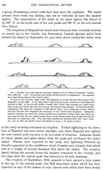
"* * * As a land mass above tidewater it was a continuous island about two miles long, with the new steaming cones in the middle 400 to 500 feet high. Grewingk, flat-topped and cliff-encompassed, guards the north end of the island, while Castle Rock, pinnacled and jagged, rises on the south. The intervening spaces were filled with sand, gravel, and volcanic bombs, making wave-washed bars ten or twelve feet above sea-level. It was unbelievable that only sixteen months ago there was nothing there, between the north and south islets, but open water, and some ten fathoms of that!
"* * * All the pinnacles of Castle Rock were sharpened between 1906 and 1907 - probably by the bombardment of falling stones and sand at the midwinter season when a violent explosion broke Metcalf Cone in twain. There are marks of flood-waves and bombs and pumice on the flats, which give good reason for the belief that the moment which ended the life of Metcalf Cone and began that of McCulloch Peak, in the winter of 1906-07, was explosive."
Jaggar (1908) estimates that old Castle Rock rose about twenty-five feet during the past eight months, and McCulloch Peak was over 400 feet high with a base of nearly 2000 feet across at sea-level. While Jaggar was at Bogoslof (August, 1907) the volcano was nearly enclosed by a lagoon of 90 degree salt water. McCulloch peak was steaming, and larger vents were coated in sulfur. Metcalf Cone was a sheer face of rock descending to the waters of the hot lagoon on the McCulloch side, and was about 400 feet wide with a 360 foot-wide base.
Jaggar (1908) further reports: "On September 1, twenty-four days after the Technology Expedition left Bogoslof, the natives, traders and revenue officers who live at Iliuliuk saw toward the west a dense black cloud rising and the air was full of sulfur fumes. About five o'clock in the afternoon ash and sand began to fall, followed by rain and distant rumbling. A quarter-inch layer from this snowstorm of sand settled on roofs and shipping and grassy landscape, making all appear wan and drooping with a monotonous gray mantle.
"The Cutter McCulloch * * * visited Bogoslof [in October] and [found] McCulloch Peak absolutely gone, a steaming lagoon in its place, and the rest of the island piled high with fallen debris. The half of Metcalf Cone was still 'standing in grim silence as a headstone at the grave of the departed peak.' The north slope of Metcalf showed the smooth cone curve, concave in profile upward, so characteristic of cinder-cones like Fuji or Vesuvius, and this marked for Bogoslof one more step in the cone-building process."
Newhall and Melson (1983) estimate that the volume of the Metcalf, McCullogh, and Tahoma Peak lava domes (1906-1910) was about 5x10^6 cubic meters.
Miller and others (1998) summarizes this eruption, which began in early 1907, as follows: "[A]nother dome emerged, joining Metcalf Cone and Old Bogoslof (Byers, 1959). This dome, McCulloch Peak, was subsequently obliterated in a violent explosion on September 1, 1907 that showered Unalaska Village with 0.5 cm of ash and mantled the remaining Bogoslof Islands with debris." The Perry likely saw McCulloch Peak on June 21, 1907, as they recorded in their logbook "Some unfamiliar pinnacle rocks between Castle and Perry Islands" (see logbook entry on Old Weather website: http://oldweather.s3.amazonaws.com/ow3/final/Commodore%20perry//Volumes/Seagate%20Backup%20Plus%20Drive/Arfon-JPEGS/RG26/COMMODORE%20PERRY//vol184/vol184_175_1.jpg.
Jaggar (1908) reports: "In the spring of 1907 Captain Dirks, a local trader, brought word that a still newer peak had risen beside Metcalf Cone. The Cutter McCulloch visited the scene in July, 1907, and reported that this was indeed true, and moreover, Metcalf Cone had half collapsed, and the channel between it and Castle Rock was filled up with the new steaming heap, "McCulloch Peak," and a wide stretch of gravel wash. Such was substantially the state of affairs when the Technology Expedition arrived August 7, 1907. A day was spent in exploring, photographing, and collecting specimens. The landing was made in dories in the midst of a herd of roaring sea-lions.
"* * * As a land mass above tidewater it was a continuous island about two miles long, with the new steaming cones in the middle 400 to 500 feet high. Grewingk, flat-topped and cliff-encompassed, guards the north end of the island, while Castle Rock, pinnacled and jagged, rises on the south. The intervening spaces were filled with sand, gravel, and volcanic bombs, making wave-washed bars ten or twelve feet above sea-level. It was unbelievable that only sixteen months ago there was nothing there, between the north and south islets, but open water, and some ten fathoms of that!
"* * * All the pinnacles of Castle Rock were sharpened between 1906 and 1907 - probably by the bombardment of falling stones and sand at the midwinter season when a violent explosion broke Metcalf Cone in twain. There are marks of flood-waves and bombs and pumice on the flats, which give good reason for the belief that the moment which ended the life of Metcalf Cone and began that of McCulloch Peak, in the winter of 1906-07, was explosive."
Jaggar (1908) estimates that old Castle Rock rose about twenty-five feet during the past eight months, and McCulloch Peak was over 400 feet high with a base of nearly 2000 feet across at sea-level. While Jaggar was at Bogoslof (August, 1907) the volcano was nearly enclosed by a lagoon of 90 degree salt water. McCulloch peak was steaming, and larger vents were coated in sulfur. Metcalf Cone was a sheer face of rock descending to the waters of the hot lagoon on the McCulloch side, and was about 400 feet wide with a 360 foot-wide base.
Jaggar (1908) further reports: "On September 1, twenty-four days after the Technology Expedition left Bogoslof, the natives, traders and revenue officers who live at Iliuliuk saw toward the west a dense black cloud rising and the air was full of sulfur fumes. About five o'clock in the afternoon ash and sand began to fall, followed by rain and distant rumbling. A quarter-inch layer from this snowstorm of sand settled on roofs and shipping and grassy landscape, making all appear wan and drooping with a monotonous gray mantle.
"The Cutter McCulloch * * * visited Bogoslof [in October] and [found] McCulloch Peak absolutely gone, a steaming lagoon in its place, and the rest of the island piled high with fallen debris. The half of Metcalf Cone was still 'standing in grim silence as a headstone at the grave of the departed peak.' The north slope of Metcalf showed the smooth cone curve, concave in profile upward, so characteristic of cinder-cones like Fuji or Vesuvius, and this marked for Bogoslof one more step in the cone-building process."
Newhall and Melson (1983) estimate that the volume of the Metcalf, McCullogh, and Tahoma Peak lava domes (1906-1910) was about 5x10^6 cubic meters.
Impact: Jaggar (1908) reported a quarter-inch of ashfall at Unalaska on September 1, 1907. [4]
References Cited
[1] Journal of the technology expedition to the Aleutian Islands, 1907, 1908
Jaggar, T. A., 1908, Journal of the technology expedition to the Aleutian Islands, 1907: The Technology Review, v. 10, n. 1, p. 1-37.[2] Volcanoes of the world [2nd edition], 1994
Simkin, Tom, and Siebert, Lee, 1994, Volcanoes of the world [2nd edition]: Tucson, Arizona, Geoscience Press, 349 p.[3] Recent volcanic eruptions in the Bering Sea, 1908
Eakle, A. S., 1908, Recent volcanic eruptions in the Bering Sea: Mining and Scientific Press, v. 96, p. 353.[4] The evolution of Bogoslof volcano, 1908
Jaggar, T. A., 1908, The evolution of Bogoslof volcano: Bulletin of the American Geographical Society of New York, v. 40, p. 385-400.[5] Recent activity of Bogoslof Volcano, 1930
Jaggar, T. A., 1930, Recent activity of Bogoslof Volcano: The Volcano Letter, v. 275, p. 1-3.[6] Evolution of Bogoslof volcano, 1931
Jaggar, T. A., 1931, Evolution of Bogoslof volcano: The Volcano Letter, v. 322, p. 1-3.[7] Notes on recent changes in the Bogoslof Islands, 1908
Smith, P. S., 1908, Notes on recent changes in the Bogoslof Islands: Science, v. 27, n. 696, p. 695.[8] Geology of Umnak and Bogoslof Islands, Aleutian Islands, Alaska, 1959
Byers, F. M. Jr., 1959, Geology of Umnak and Bogoslof Islands, Aleutian Islands, Alaska: in Investigations of Alaskan volcanoes, U.S. Geological Survey Bulletin 1028-L, p. 267-369, 5 sheets, scale 1 at 1:63,360, 1 at 1:96,000, and 1 at 1:300,000.[9] Recent changes in Bogoslof volcano, 1916
Powers, Sidney, 1916, Recent changes in Bogoslof volcano: Geographical Review, v. 2, n. 3, p. 218-221.Complete Eruption References
Catalog of the historically active volcanoes of Alaska, 1998
Miller, T. P., McGimsey, R. G., Richter, D. H., Riehle, J. R., Nye, C. J., Yount, M. E., and Dumoulin, J. A., 1998, Catalog of the historically active volcanoes of Alaska: U.S. Geological Survey Open-File Report 98-0582, 104 p.

Volcanoes of the world [2nd edition], 1994
Simkin, Tom, and Siebert, Lee, 1994, Volcanoes of the world [2nd edition]: Tucson, Arizona, Geoscience Press, 349 p.
Explosive activity associated with the growth of volcanic domes, 1983
Newhall, C. G., and Melson, W. G., 1983, Explosive activity associated with the growth of volcanic domes: Journal of Volcanology and Geothermal Research, v. 17, n. 1/4, p. 111-131.
Geology of Umnak and Bogoslof Islands, Aleutian Islands, Alaska, 1959
Byers, F. M. Jr., 1959, Geology of Umnak and Bogoslof Islands, Aleutian Islands, Alaska: in Investigations of Alaskan volcanoes, U.S. Geological Survey Bulletin 1028-L, p. 267-369, 5 sheets, scale 1 at 1:63,360, 1 at 1:96,000, and 1 at 1:300,000.

Volcanoes declare war: logistics and strategy of Pacific volcano science, 1945
Jaggar, T. A., 1945, Volcanoes declare war: logistics and strategy of Pacific volcano science: Honolulu, Paradise of the Pacific, Ltd, 166 p.
Evolution of Bogoslof volcano, 1931
Jaggar, T. A., 1931, Evolution of Bogoslof volcano: The Volcano Letter, v. 322, p. 1-3.

Recent activity of Bogoslof Volcano, 1930
Jaggar, T. A., 1930, Recent activity of Bogoslof Volcano: The Volcano Letter, v. 275, p. 1-3.

Recent changes in Bogoslof volcano, 1916
Powers, Sidney, 1916, Recent changes in Bogoslof volcano: Geographical Review, v. 2, n. 3, p. 218-221.
Recent volcanic eruptions in the Bering Sea, 1908
Eakle, A. S., 1908, Recent volcanic eruptions in the Bering Sea: Mining and Scientific Press, v. 96, p. 353.
Journal of the technology expedition to the Aleutian Islands, 1907, 1908
Jaggar, T. A., 1908, Journal of the technology expedition to the Aleutian Islands, 1907: The Technology Review, v. 10, n. 1, p. 1-37.

The evolution of Bogoslof volcano, 1908
Jaggar, T. A., 1908, The evolution of Bogoslof volcano: Bulletin of the American Geographical Society of New York, v. 40, p. 385-400.

Notes on recent changes in the Bogoslof Islands, 1908
Smith, P. S., 1908, Notes on recent changes in the Bogoslof Islands: Science, v. 27, n. 696, p. 695.
Logbooks of the U.S. Revenue Cutter Service Perry, 1906
Logbooks of the U.S. Revenue Cutter Service Perry, 1906. Transcripts available at http://www.oldweather.org/ships/523c928e68f4b82a89000002 .