Semisopochnoi
| Red (Warning) | |
| Orange (Watch) | |
| Yellow (Advisory) | |
| Green (Normal) | |
| Uninstrumented | |
| Community | |
| Webcam | |
| Instrument | |
| Earthquake Magnitude | |
|
0
| |
| Earthquake Age | |
| Last 2 Hours | |
| Last 2 Days | |
| Last 1 Week | |
Facts
- Official Name: Semisopochnoi Island
- Seismically Monitored: Yes
- Color Code: GREEN
- Alert Level: NORMAL
- Elevation: 800m (2624ft)
- Latitude: 51.9288
- Longitude: 179.5977
- Smithsonian VNum: 311060
- Pronunciation:
-
Nearby Towns:
- Adak 161 mi (259 km) SE
- Shemya Station 238 mi (383 km) NW
- Atka 264 mi (425 km) NE
- Attu Station 277 mi (445 km) NW
- Nikolski 490 mi (789 km) NE
Distance from Anchorage: 1309 mi (2107 km)
-
Subfeatures:
- Sugarloaf Peak
- Lakeshore Cone
- Mount Young
- Anvil Peak
- Pochnoi
- Ragged Top
- Three-quarter cone
Description
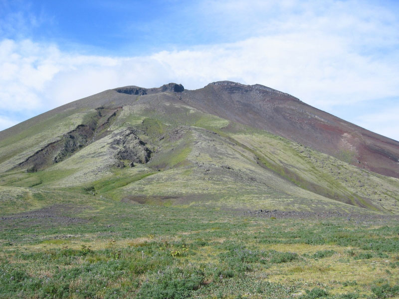
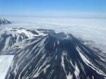
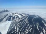
From Wood and Kienle (1990) [1] : "Semisopochnoi is the largest young volcanic island in the western Aleutians and is composed of a variety of volcanic landforms. Basaltic pyroclastic material built a shield of ~20 km wide (at sea level) which culminated in a post-glacial pumice and ash eruption of dacite and andesite, producing an 8-km-wide caldera. Smaller composite cones are both pre- and post-glacial. Mount Cerberus is the most active of the three younger cones within the caldera. These young cones are dominantly two-pyroxene, high-alumina basalt, and andesite. One young composite cone (Sugarloaf) has olivine basalt. Dacite and andesite are found among the eruptive products of the pre caldera shield. Much of the island is covered by basaltic to andesitic ash derived from the younger cones. Semisopochnoi's tholeiitic differentiation trend (iron is enriched as silica increases) and relatively large volume are common in volcanoes near segment boundaries. Semisopochnoi is also on a small submarine ridge that extends northward as a part of the scorpion-tail-shaped Bower's Ridge; it is unclear if this setting influences its volcanism."An historic eruption of Semisopochnoi was reported in 1873, and at least four others may have occurred in the previous hundred years, but documentation is scanty. These eruptions apparently emanated from the flanks of Mount Cerberus; the most recent flow appears to be less than a century old."
Name Origin
"Semisopochnoi Island" was published by Lieutenant Sarichev (1826) as "O[strov] Semisopochnyy" (Semisopochnoi Island) (Orth, 1971). While there are seven prominent peaks on Semisopochnoi, there are numerous active volcanic vents.
References Cited
[1] Volcanoes of North America: United States and Canada, 1990
Wood, C. A., and Kienle, Juergen, (eds.), 1990, Volcanoes of North America: United States and Canada: New York, Cambridge University Press, 354 p.Current Activity
Recent Updates


Webcams
![Amchitka [AHT, 381 ft]](https://www.avo.alaska.edu/ashcam-api/images/amchitka_aht/2025/87/amchitka_aht-20250329T110000Z.jpg)
![Semisopochnoi [CETU, 1041 ft]](https://www.avo.alaska.edu/ashcam-api/images/semi_cetu/2025/87/semi_cetu-20250329T111600Z.jpg)
![Semisopochnoi [CEPE, 1113 ft]](https://www.avo.alaska.edu/ashcam-api/images/semi_cepe/2025/87/semi_cepe-20250329T111100Z.jpg)
Webicorder

Color Code Timeline
Reported Activity
Modern Eruptions
13 Event Date(s)
| Eruption | |
| Questionable eruption | |
| Non-eruptive activity |
-
 2021: Semisopochnoi 2021/2
 -
2019: Semisopochnoi 2019/7
-
2018: Semisopochnoi 2018/09
-
 2015: Semisopochnoi 2015/1
 -
2014: Semisopochnoi 2014/6
-
1987: Sugarloaf Peak 1987/4
-
1873: Mount Young 1873
-
 1830: Mount Young 1830
 -
1792: Mount Young 1792/6
-
1790: Mount Young 1790
-
1772: Mount Young 1772
-
6000 yBP: Kanaga T3
-
6920 yBP: Semisopochnoi CFE


Map Images

Geologic map of Semisopochnoi Volcano.

Topographic map of Semisopochnoi Island and showing location of submarine Amchixtam Chaxsxii volcano.
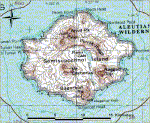
Topographic map of Semisopochnoi.
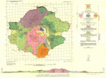
Geologic map of Semisopochnoi Island

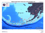
Location of Semisopochnoi volcano and other Aleutian volcanoes with respect to nearby cities and towns.
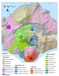
Generalized geologic map of Semisopochnoi Island, Alaska from Coombs et al. (2018). Hillshade base from Shuttle Radar Topography Mission (SRTM) 30-m digital elevation data. For Cerberus north and south cones, numbers on lava units indicate relative ages, with lowest numbers representing oldest lavas. Lines within Mount Cerberus units indicate contacts between individual lava flows. Yellow star shows location of Fenner Creek warm springs. CFE, caldera-forming eruption. Full report can be downloaded here: https://doi.org/10.3133/sir20175150
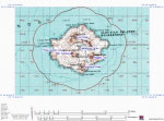
Topographic map of Semisopochnoi Island, with named cones.
Map References
Recently active volcanoes of Alaska, 2023
Historically active volcanoes of Alaska, v. 3, 2018
Historically active volcanoes of Alaska, 2014
Digital data for the reconnaissance geologic map of the western Aleutian islands, Alaska, 2006
Historically active volcanoes of the Aleutian Arc, 2002
Volcanoes of Alaska, 1998

Volcanoes of Alaska, 1995
Geothermal resources of the Aleutian Arc, 1993

Holocene volcanoes of the Aleutian Arc, Alaska, 1993
Map showing distribution, composition, and age of Late Cenozoic volcanic centers in Alaska, 1986
Geothermal energy resources of Alaska, 1980
Geologic reconnaissance of Semisopochnoi Island, western Aleutian Islands, Alaska, 1959

Ocean floor structures, northeastern Rat Islands, Alaska, 1957

Reconnaissance geology of some western Aleutian Islands, Alaska, 1956

Configuration of the Aleutian Ridge: Rat Islands-Semisopochnoi I. to west of Buldir I., 1953
Reconnaissance of the gold fields of southern Alaska with some notes on general geology, 1898
References
2022 Volcanic activity in Alaska and the Northern Mariana Islands—Summary of events and response of the Alaska Volcano Observatory, 2025
Ergodic seismic precursors and transfer learning for short term eruption forecasting at data scarce volcanoes, 2025
2020 volcanic activity in Alaska - Summary of events and response of the Alaska Volcano Observatory, 2024
2021 Volcanic activity in Alaska and the Commonwealth of the Northern Mariana Islands - Summary of events and response of the Alaska Volcano Observatory, 2024
Bulk compositions of western Aleutians tephras and lavas collected during leg 3 of the NSF GeoPRISMS shared platform for Aleutians research, Version 1.0, 2024
Recently active volcanoes of Alaska, 2023
Probabilistic source classification of large tephra producing eruptions using supervised machine learning - an example from the Alaska-Aleutian Arc, 2023
Global volcano monitoring through the Normalized Hotspot Indices (NHI) system, 2023
Alaska interagency operating plan for volcanic ash episodes, 2022

Structure of the magma plumbing system beneath Semisopochnoi Island (Aleutian Arc) inferred from seismic tomography, 2022
Geologic database of information on volcanoes in Alaska (GeoDIVA), 2022
Quantifying eruptive and background seismicity, deformation, degassing, and thermal emissions at volcanoes in the United States during 1978-2020, 2021
Gas emissions from the Western Aleutians volcanic arc, 2021
Goals and development of the Alaska Volcano Observatory seismic network and application to forecasting and detecting volcanic eruptions, 2020
Historically active volcanoes of Alaska, v. 4, 2020
Remote detection and location of explosive volcanism in Alaska with the EarthScope Transportable Array, 2020
Characterization of magma storage and dynamics at Akutan, Semisopochnoi, and Okmok volcanoes from analytical and numerical models of geodetic, seismic and petrologic data, 2020
Catalog of earthquake parameters and description of seismograph and infrasound stations at Alaskan volcanoes - January 1, 2013, through December 31, 2017, 2019
High rates of inflation during a noneruptive episode of seismic unrest at Semisopochnoi Volcano, Alaska, in 2014-2015, 2019
A unified catalog of earthquake hypocenters and magnitudes at volcanoes in Alaska: 1989 to 2018, 2019
Postglacial eruptive history and geochemistry of Semisopochnoi volcano, western Aleutian Islands, Alaska, 2018
2018 update to the U.S. Geological Survey national volcanic threat assessment, 2018
Widespread tephra layers in the Bering Sea sediments: distal clues to large explosive eruptions from the Aleutian volcanic arc, 2018
Historically active volcanoes of Alaska, v. 3, 2018
2014 Volcanic activity in Alaska - Summary of events and response of the Alaska Volcano Observatory, 2017
2015 Volcanic activity in Alaska - Summary of events and response of the Alaska Volcano Observatory, 2017
Historically active volcanoes of Alaska, 2016
Alaska Volcano Observatory image database, 2016
Geomorphic consequences of volcanic eruptions in Alaska: A review, 2015
Aleutian arc geothermal fluids: chemical analyses of waters and gases, 2015
Historically active volcanoes of Alaska, 2014
Regional controls on volcano seismicity along the Aleutian Arc, 2014

Preliminary database of Quaternary vents in Alaska, 2014
InSAR imaging of Aleutian volcanoes, 2014
Catalog of earthquake hypocenters at Alaskan volcanoes: January 1 through December 31, 2012, 2013

Catalog of earthquake hypocenters at Alaskan volcanoes: January 1 through December 31, 2011, 2012
Catalog of earthquake hypocenters at Alaskan volcanoes: January 1 through December 31, 2010, 2011
Catalog of earthquake hypocenters at Alaskan volcanoes: January 1 through December 31, 2009, 2010
Catalog of earthquake hypocenters at Alaskan volcanoes: January 1 through December 31, 2008, 2009
Chronology and references of volcanic eruptions and selected unrest in the United States, 1980-2008, 2009
Preliminary spreadsheet of eruption source parameters for volcanoes of the world, 2009
Historically active volcanoes of Alaska reference deck, 2009
Catalog of earthquake hypocenters at Alaskan volcanoes: January 1 through December 31, 2006, 2008
The Alaska Volcano Observatory - 20 years of volcano research, monitoring, and eruption response, 2008
Catalog of earthquake hypocenters at Alaskan volcanoes: January 1 through December 31, 2007, 2008
System for ranking relative threats of U.S. volcanoes, 2007

Catalog of earthquake hypocenters at Alaskan volcanoes: January 1 through December 31, 2005, 2006
Digital data for the reconnaissance geologic map of the western Aleutian islands, Alaska, 2006
An assessment of volcanic threat and monitoring capabilities in the United States: framework for a National Volcano Early Warning System NVEWS, 2005

March-April 2005, 2005
January-February 2002, 2004
Volcanoes of the world: an illustrated catalog of Holocene volcanoes and their eruptions, 2003
Bibliography of information on Alaska volcanoes, 2003
Historically active volcanoes of the Aleutian Arc, 2002
Historically active volcanoes in Alaska, a quick reference, 2000

Encyclopedia of volcanoes, 2000

Volcanoes of Alaska, 1998
Catalog of the historically active volcanoes of Alaska, 1998

Quick reference to Alaska's active volcanoes and listing of historical eruptions, 1760-1994, 1995
Volcanoes of Alaska, 1995
Age, character, and significance of Aleutian arc volcanism, 1994
Aleutian magmas in space and time, 1994
Timing of large Holocene volcanic events in the western Aleutian Arc, Alaska, 1994
Volcanoes of the world [2nd edition], 1994
Geothermal resources of Alaska, 1994
The geology, geochemistry and petrology of the recent magmatic phase of the central and western Aleutian Arc, 1994

Aleut dictionary, Unangam Tunudgusii, an unabridged lexicon of the Aleutian, Pribilof, and Commander Islands Aleut language, 1994
Geothermal resources of the Aleutian Arc, 1993
Holocene volcanoes of the Aleutian Arc, Alaska, 1993
Alaska's volcanoes, 1991
Volcanoes of North America: United States and Canada, 1990
Sugarloaf, 1990
Historical unrest at large calderas of the world, 1988
An evaluation of the global variations in the major element chemistry of arc basalts, 1988

Semisopochnoi, 1987
Map showing distribution, composition, and age of Late Cenozoic volcanic centers in Alaska, 1986
Magmatic evolution of Semisopochnoi Island, Alaska: trace-element and isotopic constraints, 1985
The Aleutians, 1982
Volcanoes of the world, 1981
Magmatic evolution of Little Sitkin and Semisopochnoi volcanoes, Alaska, 1980
Geothermal energy resources of Alaska, 1980
Igneous-related geothermal systems, 1979
Assessment of geothermal resources of the United States--1978, 1979
Comprehensive tables giving physical data and thermal energy estimates for young igneous systems of the United States, 1978
Igneous-related geothermal systems, 1975
Geologic reconnaissance of Semisopochnoi Island, western Aleutian Islands, Alaska, 1959
Alaska Peninsula-Aleutian Islands, 1958

Ocean floor structures, northeastern Rat Islands, Alaska, 1957
Reconnaissance geology of some western Aleutian Islands, Alaska, 1956
Configuration of the Aleutian Ridge: Rat Islands-Semisopochnoi I. to west of Buldir I., 1953
Exploring Aleutian volcanoes, 1948

Reconnaissance geology of some western Aleutian Islands, 1947
United States coast pilot, Alaska Part 2, Yakutat Bay to Arctic Ocean, 1947
Some Aleutian volcanoes, 1927
The Aleutian Islands, 1927
Reminiscences of Alaskan volcanoes, 1918
Katalog der geschichtlichen vulkanausbruche, 1917

The volcanoes of Alaska, 1910
Reported volcanic eruptions in Alaska, Puget Sound, etc., 1690-1896, 1898

Reconnaissance of the gold fields of southern Alaska with some notes on general geology, 1898
The volcanic region of Alaska, 1884
Alaska and its resources, 1870
Documents sur les tremblements de terre et les phenomenes volcaniques des iles Aleutiennes, de la peninsule d'Aljaska et de la cote no. d'Amerique, Extrait des memoires de l'Academie des sciences, arts et belles-lettres de Dijon, 1865, 1866

Grewingk's geology of Alaska and the Northwest Coast of America [edited by Marvin W. Falk, translation by Fritz Jaensch published 2003], 1850
Before an eruption
Ashfall & Preparedness Information
- Ashfall impacts & preparedness (US Geological Survey)
- Volcanic health hazards & impacts (International Volcanic Health Hazards Network)
- Ash Alert! Pamphlet (AK Division of Homeland Security & Emergency Management)
- Volcanic Ashfall (AK Department of Environmental Conservation, Division of Air Quality)
During and After an Eruption
Ash Forecasting
Mathematical models developed by the USGS forecast various aspects of how a volcanic ash plume will interact with wind—where, how high, and how fast ash particles will be transported in the atmosphere, as well as where ash will fall out and accumulate on the ground. AVO runs these models when a volcano is restless by assuming a reasonable hypothetical eruption, to provide a pre-eruptive forecast of areas likely to be affected. During an ongoing eruption, AVO will update the forecast with actual observations (eruption start time and duration, plume height) as they become available.
View the current airborne ash cloud models for Semisopochnoi
Ashfall thickness forecast
The Ash3d model was developed by the USGS to forecast how a volcanic ash plume will interact with wind and where ash will fall out and accumulate on the ground. AVO runs these models twice daily when a volcano is restless by assuming a reasonable hypothetical eruption altitude and duration. The map shows the model results of ashfall thickness for areas that are likely to be affected, if one were to occur. During an ongoing eruption, AVO will update the forecast with actual observations (eruption start time and duration, plume height) as they become available, and these plots will be automatically updated. The National Weather Service Anchorage Forecast Office will issue the official ashfall warning product and post them at weather.gov/afc
THESE PRODUCTS MAY NOT BE CURRENT.During an actual eruption, see National Weather Service forecasts of ashfall:https://weather.gov/afc.
Ashfall Forecast
Ashfall Start Time
This map shows the modeled estimate of the time it would take for ashfall to begin following an eruption. It corresponds to the ashfall thickness forecast map shown above. This map uses the start time of either the twice-daily hypothetical model runs (time shown in the legend) or the actual eruption start time (if one were to occur). In the case of an actual eruption, the National Weather Service Anchorage Forecast Office will issue the official ashfall warning product that includes the ashfall start time and post them at weather.gov/afc
THESE PRODUCTS MAY NOT BE CURRENT.During an actual eruption, see National Weather Service forecasts of ashfall:https://weather.gov/afc.