References
McNutt, S.R., 2025, Long swarms and short swarms at volcanoes - evidence for different processes: Annals of Geophysics v. 68, no. 1, 16 p. https://doi.org/10.4401/ag-9156
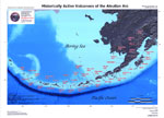
Cameron, C.E., Bull, K.F., and Macpherson, A.E., 2023, Recently active volcanoes of Alaska: Alaska Division of Geological & Geophysical Surveys Miscellaneous Publication 133 v. 6, 2 sheets. https://doi.org/10.14509/31086.
Wang, J., Lu, Z., Bekaert, D., Marshak, C., Govorcin, M., Sangha, S., Kennedy, J., and Gregg, P., 2023, Along-arc volcanism in the western and central Aleutian from 2015 to 2021 revealed by cloud-based InSAR processing: Geophysical Research Letters v. 50, no. 23, e2023GL106323. https://doi.org/10.1029/2023GL106323
Hornby, A., Gazel, E., Bush, C., Dayton, K., and Mahowald, N., 2023, Phases in fine volcanic ash: Scientific Reports v. 13, 15728. https://doi.org/10.1038/s41598-023-41412-x
Alaska Volcano Observatory, National Oceanic and Atmospheric Administration, National Weather Service, Federal Aviation Administration, Department of Defense, United States Coast Guard, Division of Homeland Security and Emergency Management, Alaska Department of Environmental Conservation, and Alaska Department of Health and Social Services (participating agencies), 2022, Alaska interagency operating plan for volcanic ash episodes, 85 p.
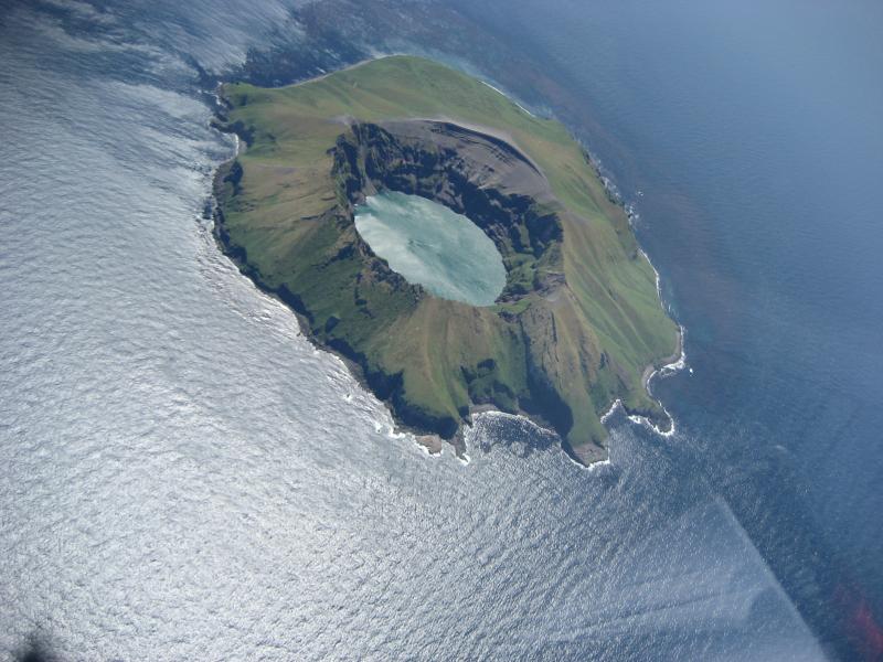
Waythomas, C.F., 2022, Selected crater and small caldera lakes in Alaska: Characteristics and hazards: Frontiers in Earth Science, v. 9, p. 23, doi:10.3389/feart.2021.751216.
Cameron, C.E., Crass, S.W., and AVO Staff, eds, 2022, Geologic database of information on volcanoes in Alaska (GeoDIVA): Alaska Division of Geologic and Geophysical Surveys Digital Data Series 20, https://doi.org/10.14509/geodiva, https://doi.org/10.14509/30901.
Reath, K., Pritchard, M.E., Roman, D.C., Lopez, T., Carn, S., Fischer, T.P., Lu, Z., Poland, M.P., Vaughan, R.G., Wessels, R., Wike, L.L., and Tran, H.K., 2021, Quantifying eruptive and background seismicity, deformation, degassing, and thermal emissions at volcanoes in the United States during 1978-2020: Journal of Geophysical Research: Solid Earth, v. 126, e2021JB021684, doi: 10.1029/2021JB021684.
Pesicek, J. D., Ogburn, S. E., and Prejean, S. G., 2021, Indicators of volcanic eruptions revealed by global M4+ earthquakes: Journal of Geophysical Research: Solid Earth, v. 126, no. 3 https://doi.org/10.1029/2020JB021294.
Cameron, C.E., Schaefer, J.R., and Ekberg, P.G., 2020, Historically active volcanoes of Alaska: Alaska Division of Geological & Geophysical Surveys Miscellaneous Publication 133 v. 4, 2 sheets. Http://doi.org/10.14509/30426
White, R.A., and McCausland, W.A., 2019, A process-based model of pre-eruption seismicity patterns and its use for eruption forecasting at dormant stratovolcanoes: Journal of Volcanology and Geothermal Research, v. 382, p. 267-297, doi: http://dx.doi.org/10.1016/j.jvolgeores.2019.03.004.
Westberry, T.K., Shi, Y.R., Yu, H., Behrenfeld, M.J., and Remer, L.A., 2019, Satellite-detected ocean ecosystem response to volcanic eruptions in the subarctic Northeast Pacific Ocean: Geophysical Research Letters, v. 6, n. 20, p. 11270-11280, doi: http://dx.doi.org/10.1029/2019GL083977.
Mulliken, K.M., 2018, The Alaska Volcano Observatory: 30 years of protecting Alaskans from the effects of volcanic activity (1988-2018): Alaska Division of Geological & Geophysical Surveys Information Circular 67, 2 p. http://doi.org/10.14509/30032
Ewert, J.W., Diefenbach, A.K., and Ramsey, D.W., 2018, 2018 update to the U.S. Geological Survey national volcanic threat assessment: U.S. Geological Survey Scientific Investigations Report 2018-5140, 40 p., https://pubs.usgs.gov/sir/2018/5140/sir20185140.pdf.
Cameron, C.E., Schaefer, J.R., and Mulliken, K.M., 2018, Historically active volcanoes of Alaska: Alaska Division of Geological & Geophysical Surveys Miscellaneous Publication 133 v. 3, 2 sheets. Http://doi.org/10.14509/30142
Drew, Gary, Piatt, J.F., and Williams, Jeff, 2018, Biological responses of Crested and Least auklets to volcanic destruction of nesting habitat in the Aleutian Islands, Alaska: The Auk, v. 135, no. 3, p. 477-485.
Matoza, R. S., Green, D. N., Le Pichon, A., Shearer, P. M., Fee, D., Mialle, P., and Ceranna, L., 2017, Automated detection and cataloging of global explosive volcanism using the International Monitoring System infrasound network: Journal of Geophysical Research: Solid Earth, v. 122, n. 4, p. 2946-2971, doi:http://dx.doi.org/10.1002/2016JB013356.
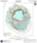
Nye, Chris, 2017, Kasatochi Island 2009 topography: Alaska Division of Geological & Geophysical Surveys Miscellaneous Publication 163, 1 sheet, scale 1:10,000. http://doi.org/10.14509/29733
Nye, C.J., Scott, W.E., Neill, O.K., Waythomas, C.F., Cameron, C.E., and Calvert, A.T., 2017, Geology of Kasatochi volcano, Aleutian Islands, Alaska: Alaska Division of Geological & Geophysical Surveys Professional Report 123, 127 p., 1 sheet, scale 1:5000. http://doi.org/10.14509/29718
Sonsthagen, S.A., Williams, J.C., Drew, G.S., White, C.M., Sage, G.K., and Talbot, S.L., 2017, Legacy or colonization? Posteruption establishment of peregrine falcons (Falco peregrinus) on a volcanically active subarctic island: Ecology and evolution, v. 7, n. 1, p. 107-114.
Schoenhardt, Anja, Richter, Andreas, Theys, Nicolas, and Burrows, J.P., 2017, Space-based observation of volcanic iodine monoxide: Atmospheric Chemistry and Physics, v. 17, n. 7, p. 4857-4870, doi: http://dx.doi.org/10.5194/acp-17-4857-2017.
Cameron, C.E., and Schaefer, J.R., 2016, Historically active volcanoes of Alaska: Alaska Division of Geological & Geophysical Surveys Miscellaneous Publication 133 v. 2, 1 sheet, scale 1:3,000,000. http://doi.org/10.14509/20181
Crawford, A. M., Stunder, B. J., Ngan, F., and Pavolonis, M. J., 2016, Initializing HYSPLIT with satellite observations of volcanic ash: A case study of the 2008 Kasatochi eruption: Journal of Geophysical Research: Atmospheres, v. 121, n. 18, p. 10,786-10,803.
Michaelson, G. J., Wang, B., and Ping, C. L., 2016, Fertility of the early post-eruptive surfaces of Kasatochi Island volcano: Arctic, Antarctic, and Alpine Research, v. 48, n. 1, p. 45-59.
Cameron, C.E., and Snedigar, S.F., 2016, Alaska Volcano Observatory image database: Alaska Division of Geological & Geophysical Surveys Digital Data Series 13, https://www.avo.alaska.edu/images/. https://doi.org/10.14509/29689.
Neill, O.K., Larsen, J.F., Izbekov, P.E., and Nye, C.J., 2015, Pre-eruptive magma mixing and crystal transfer revealed by phenocryst and microlite compositions in basaltic andesite from the 2008 eruption of Kasatochi Island volcano: American Mineralogist, v. 100, n. 4, p. 722-737, doi: 10.2138/am-2015-4967
Waythomas, C.F., 2015, Geomorphic consequences of volcanic eruptions in Alaska: A review: Geomorphology, v. 246, p. 123-145, doi: 10.1016/j.geomorph.2015.06.004
McNutt, S.R., Thompson, G., Johnson, J.B., De Angelis, S., and Fee, D., 2015, Seismic and infrasound monitoring: in Sigurdsson, H., Houghton, B.F., Rymer, H., Stix, J., and McNutt, S. (eds.), The encyclopedia of volcanoes (2nd ed): Academic Press, p. 1071-1099, http://dx.doi.org/10.1016/B978-0-12-385938-9.00063-8
Evans, W.C., Bergfeld, D., Neal, C.A., McGimsey, R.G., Werner, C.A., Waythomas, C.F., Lewicki, J.L., Lopez, T., Mangan, M.T., Miller, T.P., Diefenbach, A., Schaefer, J., Coombs, M.L., Wang, B., Nicolaysen, K., Izbekov, P., Maharrey, Z., Huebner, M., Hunt, A.G., Fitzpatrick, J., and Freeburg, G., 2015, Aleutian Arc geothermal fluids: chemical analyses of waters and gases: U.S. Geological Survey Data release, http://dx.doi.org/10.5066/F74X55VB
Egan, S. D., Stuefer, M., Webley, P., and Cahill, C. F., 2015, WRF-Chem modeling of sulfur dioxide emissions from the 2008 Kasatochi Volcano: Annals of Geophysics, 57, p. 1-6.
Schaefer, J.R., Cameron, C.E., and Nye, C.J., 2014, Historically active volcanoes of Alaska: Alaska Division of Geological & Geophysical Surveys Miscellaneous Publication 133 v. 1.2, 1 sheet, scale 1:3,000,000.
This publication has been superseded. Newest version available at http://www.dggs.alaska.gov/pubs/id/20181 .
Neal, C.A., Herrick, J., Girina, O.,A., Chibisova, M., Rybin, A., McGimsey, R.G., and Dixon, J., 2014, 2010 Volcanic activity in Alaska, Kamchatka, and the Kurile Islands - Summary of events and response of the Alaska Volcano Observatory: U.S. Geological Survey Scientific Investigations Report 2014-5034, 76 p., http://dx.doi.org/10.3133/sir20145034 .
Cameron, C.E., and Nye, C.J., 2014, Preliminary database of Quaternary vents in Alaska: Alaska Division of Geological & Geophysical Surveys Miscellaneous Publication 153, 11 p., doi:10.14509/27357 .
Lu, Zhong, and Dzurisin, Daniel, 2014, InSAR imaging of Aleutian volcanoes: Chichester, UK, Springer-Praxis, 390 p.
Guffanti, Marianne, and Miller, Tom, 2013, A volcanic activity alert-level system for aviation: review of its development and application in Alaska: Natural Hazards, 15 p., doi:0.1007/s11069-013-0761-4
Neill, O.K., 2013, Petrologic and geochemical tracers of magmatic movement in volcanic arc systems: case studies from the Aleutian Islands and Kamchatka, Russia: University of Alaska Fairbanks Ph.D., 188 p.
Andersson, S., Martinsson, B.G., Friberg, J., Brenninkmeijer, C.A.M., Rauthe-Schoch, A, Hermann, M., van Velthoven, P.F.J., and Zahn, A., 2013, Composition and evolution of volcanic aerosol from eruptions of Kasatochi, Sarychev, and Eyjafjallajokull in 2008-2010 based on CARIBIC observations: Atmospheric Chemistry and Physics, v. 13, n. 4, p. 1781-1796, http://dx.doi.org/10.5194/acp-13-1781-2013
Wang, J., Park, S., Zeng, J., Ge, C., Yang, K., Carn, S., Krotkov, N., and Omar, A., 2013, Modeling of 2008 Kasatochi volcanic sulfate direct radiative forcing: assimilation of OMI SO2 plume height data and comparison with MODIS and CALIOP observations: Atmospheric Chemistry and Physics, v. 13, n. 4, p. 1895-1912, http://dx.doi.org/10.5194/acp-13-1895-2013
Pouget, Solene, Bursik, Marcus, Webley, Peter, Dehn, Jon, and Pavolonis, Michael, 2013, Estimation of eruption source parameters from umbrella cloud or downwind plume growth rate: Journal of Volcanology and Geothermal Research, v. 258, p. 100-112, http://dx.doi.org/10.1016/j.jvolgeores.2013.04.002
Steensen, T. S., 2013, Satellite to model comparisons of volcanic ash emissions in the North Pacific: University of Alaska Fairbanks Ph.D. dissertation, 251 p.
Kentner, A., 2013, Petrological constraints on the origin of enclaves from Kasatochi Volcano, Aleutian Islands, Alaska: University of Alaska M.S. thesis, 166 p.
Hard Copy held by AVO at FBKS - CEC shelf
Bond, A.L., Evans, W.C., and Jones, I.L., 2012, Avian mortality associated with a volcanic gas seep at Kiska Island, Aleutian Islands, Alaska: The Wilson Journal of Ornithology, v. 124, n. 1, p. 146-151.
Prejean, Stephanie, Moran, Seth, and Power, John, 2012, Volcanic earthquakes in Alaska's National Parks: in Winfree, Robert (project lead), Katmai Science Studies: Alaska Park Science Journal, v. 11, n. 1, p. 40-45, available online at http://www.nps.gov/akso/nature/science/ak_park_science/volume_11_issue_1.cfm .
Hard Copy held by AVO at FBKS - CEC shelf
Coletti, H.A., 2012, Possible effects of a volcanic eruption on the nearshore environment: in Winfree, Robert (project lead), Katmai Science Studies: Alaska Park Science Journal, v. 11, n. 1, p. 78-81, available online at http://www.nps.gov/akso/nature/science/ak_park_science/volume_11_issue_1.cfm .
Hard Copy held by AVO at FBKS - CEC shelf
Neal, C.A., McGimsey, R.G., Dixon, J.P., Cameron, C.E., Nuzhaev, A.A., and Chibisova, Marina, 2011, 2008 Volcanic activity in Alaska, Kamchatka, and the Kurile Islands: Summary of events and response of the Alaska Volcano Observatory: U.S. Geological Survey Scientific Investigations Report 2010-5243, 94 p., available at http://pubs.usgs.gov/sir/2010/5243 .
Ruppert, N.A., Prejean, Stephanie, and Hansen, R.A., 2011, Seismic swarm associated with the 2008 eruption of Kasatochi Volcano, Alaska: Earthquake locations and source parameters: Journal of Geophysical Research, v. 116, n. B00B07, 18 p., doi:10.1029/2010JB007435 .
Prejean, S.G., and Brodsky, E.E., 2011, Volcanic plume height measured by seismic waves based on a mechanical model [abs.]: Journal of Geophysical Research, v. 116, n. B1, 1 p.
Dabrowa, A.L., Green, D.N., Rust, A.C., and Phillips, J.C., 2011, A global study of volcanic infrasound characteristics and the potential for long-range monitoring: Earth and Planetary Science Letters, v. 310, p. 369-379, doi:10.1016/j.epsl.2011.08.027.
Clarisse, Lieven, Coheur, P-F., Chefdeville, Simon, Lacour, J.L., Hurtmans, Daniel, and Clerbaux, Cathy, 2011, Infrared satellite observations of hydrogen sulfide in the volcanic plume of the August 2008 Kasatochi eruption: Geophysical Research Letters, v. 398, n. 10, L10804, 4 p., doi:10.1029/2011GL047402
Munoz, A.G., Palle, E., Osorio, M.R.Z., and Martin, E.L., 2011, The impact of the Kasatochi eruption on the Moon's illumination during the August 2008 lunar eclipse: Geophysical Research Letters, v. 38, n. 14, 5 p., doi:10.1029/2011GL047981 .
Prejean, S.G, and Brodsky, E.E., 2011, Volcanic plume height measured by seismic waves based on a mechanical model: Journal of Geophysical Research, v. 116, n. B1, B0106, 13 p., doi: 10.1029/2010JB007620 .
Degange, Anthony, 2010, U.S. Geological Survey (USGS) Western Region: Kasatochi Volcano coastal and ocean science: U.S. Geological Survey Fact Sheet 2010-3028, 2 p., available online at http://pubs.usgs.gov/fs/2010/3028 .
Rozell, N., 2010, Escape from Kasatochi: Alaska Magazine, v. 74, n. 2, February 2010, p. 54-55, 73.
Hard Copy held by AVO at FBKS - CEC shelf
Scott, W.E., Nye, C.J., Waythomas, C.F., and Neal, C.A., 2010, August 2008 eruption of Kasatochi Volcano, Aleutian Islands, Alaska - resetting an island landscape: Arctic, Antarctic, and Alpine Research, v. 42, n.3, p. 250-259, doi:10.1657/1938-4246-42.3.250 .
Waythomas, C.F., Scott, W.E., and Nye, C.J., 2010, The geomorphology of an Aleutian volcano following a major eruption: the 7-8 August 2008 eruption of Kasatochi Volcano, Alaska, and its aftermath: Arctic, Antarctic, and Alpine Research, v. 42, n. 3, p. 260-275, doi:10.1657/1938-4246-42.3.260 .
DeGange, A.R., Byrd, G.V., Walker, L.R., and Waythomas, C.F., 2010, Introduction - the impacts of the 2008 eruption of Kasatochi Volcano on terrestrial and marine ecosystems in the Aleutian Islands, Alaska: Arctic, Antarctic, and Alpine Research, v. 42, n. 3., p. 245-249, doi: 10.1657/1938-4246-42.3.245 .
del Moral, Roger, 2010, The importance of long-term studies of ecosystem reassembly after the eruption of the Kasatochi Island volcano: Arctic, Antarctic, and Alpine Research, v. 42, n. 3., p. 335-341, doi: 10.1657/1938-4246-42.3.335 .
Drew, G.S., Dragoo, D.E., Renner, Martin, and Piatt, J.F., 2010, At-sea observations of marine birds and their habitats before and after the 2008 eruption of Kasatochi volcano, Alaska: Arctic, Antarctic, and Alpine Research, v. 42, n. 3, p. 325-334, doi: 10.1657/1938-4246-42.3.325 .
Jewett, S.C., Bodkin, J.L., Chenelot, Heloise, Esslinger, G.G., and Hoberg, M.K., 2010, The nearshore benthic community of Kasatochi Island, one year after the 2008 volcanic eruption: Arctic, Antarctic, and Alpine Research, v. 42, n. 3, p. 315-324, doi: 10.1657/1938-4246-42.3.315 .
Sikes, D.S., and Slowik, Jozef, 2010, Terrestrial arthropods of pre- and post-eruption Kasatochi Island, Alaska, 2008-2009: a shift from a plant-based to a necromass-based food web: Arctic, Antarctic, and Alpine Research, v. 42, n. 3, p. 297-305, doi: 10.1657/1938-4246-42.3.297 .
Talbot, S.S., Talbot, S.L., and Walker, L.R., 2010, Post-eruption legacy effects and their implications for long-term recovery of the vegetation on Kasatochi Island, Alaska: Arctic, Antarctic, and Alpine Research, v. 42, n. 3, p. 285-296, doi: 10.1657/1938-4246-42.3.285 .
Wang, Bronwen, Michaelson, Gary, Ping, Chien-Lu, Plumlee, Geoffrey, and Hageman, Philip, 2010, Characterization of pyroclastic deposits and pre-eruptive soils following the 2008 eruption of Kasatochi Island volcano, Alaska: Arctic, Antarctic, and Alpine Research, v. 42, n. 3, p. 276-284, doi: 10.1657/1938-4246-42.3.276 .
Williams, J.C., Drummond, B.A., and Buxton, R.T., 2010, Initial effects of the August 2008 volcanic eruption on breeding birds and marine mammals at Kasatochi Island, Alaska: Arctic, Antarctic, and Alpine Research, v. 42, n. 3, p. 306-314, doi: 10.1657/1938-4246-42.3.306 .
Fee, David, Steffke, Andrea, and Garces, Milton, 2010, Characterization of the 2008 Kasatochi and Okmok eruptions using remote infrasound arrays: Journal of Geophysical Research, v. 115, n. D00L10, 15 p., doi:10.1029/2009JD013621 .
Hamme, R.C., Webley, P.W., Crawford, W.R., Whitney, F.A., DeGrandpre, M.D., Emerson, S.R., Eriksen, C.C., Giesbrecht, K.E., Gower, J.F.R., Kavanaugh, M.T., Pena, M.A., Sabine, C.L., Batten, S.D., Coogan, L.A., Grundle, D.S., and Lockwood, Deirdre, 2010, Volcanic ash fuels anomalous plankton bloom in subarctic northeast Pacific: Geophysical Research Letters, v. 37, L19604, 5 p., doi: 10.1029/2010GL044629 .
Arnoult, K.M., Olson, J.V., Szuberla, C.A.L., McNutt, S.R., Garces, M.A., Fee, David, and Hedlin, M.A.H., 2010, Infrasound observations of the 2008 explosive eruptions of Okmok and Kasatochi volcanoes, Alaska: Journal of Geophysical Research, v. 115, n. D00L14, 12 p.,
doi: 10.1029/2010JD013987 .
Guffanti, Marianne, Casadevall, T.J., and Budding, Karin, 2010, Encounters of aircraft with volcanic ash clouds: A compilation of known incidents, 1953-2009: U.S. Geological Data Series 545, ver. 1.0, 12 p., plus 4 appendixes including the compliation database, available only at http://pubs.usgs.gov/ds/545 .
Neal, C.A., and Guffanti, Marianne, 2010, Airborne volcanic ash - a global threat to aviation: U.S. Geological Survey Fact Sheet 2010-3116, 6 p., available online at http://pubs.usgs.gov/fs/2010/3116/fs2010-3116.pdf .
Bitar, L., Duck, T.J., Kristiansen, N.I., Stohl, A., and Beauchamp, S., 2010, Lidar observations of Kasatochi volcano aerosols in the troposphere and stratosphere: Journal of Geophysical Research, v. 115, n. D00L13, 10 p., doi:10.1029/2009JD013650 .
Bourassa, A.E., Degenstein, D.A., Elash, B.J., and Llewellyn, E.J., 2010, Evolution of the stratospheric aerosol enhancement following the eruptions of Okmok and Kasatochi: Odin-OSIRIS measurements: Journal of Geophysical Research, v. 115, n. D00L03, 7 p., doi:10.1029/2009JD013274 .
Corradini, S., Merucci, L., Prata, A.J., and Piscini, A., 2010, Volcanic ash and SO2 in the 2008 Kasatochi eruption: Retrievals comparison from different IR satellite sensors: Journal of Geophysical Research, v. 115, n. D00L21, 10 p., doi:10.1029/2009JD013634 .
D'Amours, Real, Malo, Alain, Servranckx, Rene, Bensimon, Dov, Trudel, Serge, and Gauthier-Bilodeau, Jean-Phillipe, 2010, Application of the atmospheric Lagrangian particle dispersion model MLDP0 to the 2008 eruption of Okmok and Kasatochi volcanoes: Journal of Geophysical Research, v. 115, n. D00L11, 11p., doi: 10.1029/2009JD013602.
Guffanti, Marianne, Schneider, D.J., Wallace, K.L., Hall, Tony, Bensimon, D.R., and Salinas, L.J., 2010, Aviation response to a widely dispersed volcanic ash and gas cloud from the August 2008 eruption of Kasatochi, Alaska, USA: Journal of Geophysical Research, v. 115, n. D00L19, 9 p., doi:10.1029/2010JD013868 .
Hoffman, A., Ritter, C., Stock, M., Maturilli, M., Eckhardt, S., Herber, A., and Neuber, R., 2010, Lidar measurements of the Kasatochi aerosol plume in August and September 2008 in Ny-Alesund, Spitsbergen: Journal of Geophysical Research, v. 115, n. D00L12, 12 p., doi:10.1029/2009JD013039 .
Jurkat, T., Voigt, C., Arnold, F., Schlager, H., Aufmhoff, H., Schmale, J., Schneider, J., Lichtenstern, M., and Dornbrack, A, 2010, Airborne stratospheric ITCIMS measurements of SO2, HCl, and HNO3 in the aged plume of volcano Kasatochi: Journal of Geophysical Research, v. 115, n. D00L17, 14 p., doi:10.1029/2010JD013890 .
Karagulian, F., Clarisse, L., Clerbaux, C., Prata, A.J., Hurtmans, D., and Coheur, P.F., 2010, Detection of volcanic SO2, ash, and H2SO4 using the Infrared Atmospheric Sounding Interferometer (IASI): Journal of Geophysical Research v. 115, n. D00L02, 10 p., doi:10.1029/2009JD012786 .
Kristiansen, N.I., Stohl, A., Prata, A.J., Richter, A., Eckhardt, S., Seibert, P., Hoffman, A., Ritter, C., Bitar, L., Duck, T.J., and Stebel, K., 2010, Remote sensing and inverse transport modeling of the Kasatochi eruption sulfur dioxide cloud: Journal of Geophysical Research, v. 115, n. D00L16, 16 p., doi:10.1029/2009JD013286.
Langmann, Baerbel, Zaksek, Klemen, and Hort, Matthias, 2010, Atmospheric distribution and removal of volcanic ash after the eruption of Kasatochi volcano: a regional model study: Journal of Geophysical Research, v. 115, n, D00L06, 10 p., doi:10.1029/2009JD013298 .
Sioris, C.E., Boone, C.D., Bernath, P.F., Zou, J., McElroy, C.T., and McLinden, C.A., 2010, Atmospheric Chemistry Experiment (ACE) observations of aerosol in the upper troposphere and lower stratosphere from the Kasatochi volcanic eruption: Journal of Geophysical Research, v. 115, n. D00L14, 12 p., doi:10.1029/2009JD013469 .
Mattis, Ina, Seifert, Patric, Muller, Detlef, Tesche, Matthias, Hiebsch, Anja, Kanitz, Thomas, Schmidt, Jorg, Finger, Fanny, Wandinger, Ulla, and Ansmann, Albert, 2010, Volcanic aerosol layers observed with multiwavelength Raman lidar over central Europe in 2008-2009: Journal of Geophysical Research, v. 115, n. D00L04, 9 p., doi:10.1029/2009JD013472 .
Kravitz, Ben, Robock, Alan, and Bourassa, Adam, 2010, Negligible climatic effects from the 2008 Okmok and Kasatochi volcanic eruptions: Journal of Geophysical Research, v. 115, n. D00L05, 16p., doi:10.1029/2009JD013525 .
Prata, A.J., Gangale, G., Clarisse, L., and Karagulian, F., 2010, Ash and sulfur dioxide in the 2008 eruptions of Okmok and Kasatochi: Insights from high spectral resolution satellite measurements: Journal of Geophysical Research, v. 115, n. D00L18, 18 p., doi:10.1029/2009JD013556 .
Schmale, J., Schneider, J., Jurkat, T., Voigt, C., Kalesse, H., Rautenhaus, M., Lichtenstern, M., Schlager, H., Ancellet, G., Arnold, F., Gerding, M., Mattis, I., Wendisch, M., and Borrmann, S., 2010, Aerosol layers from the 2008 eruptions of Mount Okmok and Mount Kasatochi: In situ upper troposphere and lower stratosphere measurements of sulfate and organics over Europe: Journal of Geophysical Research, v. 115, n. D00L07, 18 p., doi:10.1029/2009JD013628 .
Waythomas, C.F., Scott, W.E., Prejean, S.G., Schneider, D.J., Izbekov, Pavel, and Nye, C.J., 2010, The 7-8 August 2008 eruption of Kasatochi Volcano, central Aleutian Islands, Alaska: Journal of Geophysical Research, v. 115, n. B00B06, 23 p., doi:10.1029/2010JB007437 .
Yang, Kai, Liu, Xiong, Bhartia, P.K., Krotkov, N.A., Carn, S.A., Hughes, E.J., Krueger, A.J., Spurr, R.J.D., and Trahan, S.G., 2010, Direct retrieval of sulfur dioxide amount and altitude from spaceborne hyperspectral UV measurements: theory and application: Journal of Geophysical Research, v. 115, n. D00L09, 15 p., doi:10.1029/2010JD013982
Krotkov, N.A., Schoeberl, M.R., Morris, G.A., and Yang, K., 2010, Dispersion and lifetime of the SO2 cloud from the August 2008 Kasatochi eruption: Journal of Geophysical Research, v. 115, n. D00L20, 13 p., doi:10.1029/2010JD013984 .
McCarthy, E.B., 2010, Quantifcation of volcanogenic water vapor using the atmospheric infrared sounder (AIRS): Michigan Technological University Ph.D. dissertation, 170 p.
Langmann, B., Zaksek, K., Hort, M., and Duggen, S., 2010, Volcanic ash as fertiliser for the surface ocean: Atmospheric Chemistry and Physics, v. 10, n. 8, p. 3891-3899, open access available at http://www.atmos-chem-phys.net/10/3891/2010/acp-10-3891-2010.pdf .
Heue, K.-P., Brenninkmeijer, C.A.M., Wagner, T., Mies, K., Dix, B., Friess, U., Martinsson, B.G., Slemr, F., and van Velthoven, P.F.J., 2010, Observations of the 2008 Kasatochi volcanic SO2 plume by CARIBIC aircraft DOAS and GOME-2 satellite: Atmospheric Chemistry and Physics, v. 10, n. 10, p. 4699-4713, online access at http://www.atmos-chem-phys.net/10/4699/2010/acp-10-4699-2010.pdf .
University of Alaska Fairbanks Geophysical Institute, 2010, Geophysical Institute, 2007-2010 report: 48 p., available online at http://www.gi.alaska.edu/admin/info/gireport
McCarthy, E.B., 2010, Quantifications of volcanogenic water vapor using the atmospheric infrared sounder (AIRS): Michigan Techological University Ph.D. dissertation, 170 p.
Bitar, L., Duck, T.J., Kristiansen, N.I., Stohl, A., and Beauchamp, S., 2010, Lidar observations of Kasatochi volcano aerosols in the troposphere and stratosphere: Journal of Geophysical Research, v. 115, n. D00L13, doi:10.1029/2009JD013650
Neal, C.A., McGimsey, R.G., Dixon, J.P., Manevich, Alexander, and Rybin, Alexander, 2009, 2006 Volcanic activity in Alaska, Kamchatka, and the Kurile Islands: Summary of events and response of the Alaska Volcano Observatory: U.S. Geological Survey Scientific Investigations Report 2008-5214, 102 p., available at http://pubs.usgs.gov/sir/2008/5214/ .
Dixon, J.P., and Stihler, S.D., 2009, Catalog of earthquake hypocenters at Alaskan volcanoes: January 1 through December 31, 2008: U.S. Geological Survey Data Series 467, 88 p., available at http://pubs.usgs.gov/ds/467/ .
Webley, P.W., Dehn, J., Lovick, J., Dean, K.G., Bailey, J.E., and Valcic, L., 2009, Near-real-time volcanic ash cloud detection: Experiences from the Alaska Volcano Observatory: Journal of Volcanology and Geothermal Research, v. 186, n. 1-2, p. 79-90, doi:10.1016/j.jvolgeores.2009.02.010 .
Theys, N., van Roozendael, M., Dils, B., Hendrick, F., Hao, N., and de Maziere, M., 2009, First satellite detection of volcanic bromine monoxide emission after the Kasatochi eruption: Geophysical Research Letters, v. 36, n. 3, 5 p. doi:10.1029/2008GL036552 .
Snedigar, S.F., and Cameron, C.C., 2009, Historically active volcanoes of Alaska reference deck: Alaska Division of Geological & Geophysical Surveys Information Circular 59, 52 p, available to order from http://www.dggs.dnr.state.ak.us/pubs/pubs?reqtype=citation&ID=20401 .
Diefenbach, A.K., Guffanti, Marianne, and Ewert, J.W., 2009, Chronology and references of volcanic eruptions and selected unrest in the United States, 1980-2008: U.S. Geological Survey Open-File Report 2009-1118, 85 p., available at http://pubs.usgs.gov/of/2009/1118/ .
Mastin, L.G., Guffanti, Marianne, Ewert, J.E., and Spiegel, Jessica, 2009, Preliminary spreadsheet of eruption source parameters for volcanoes of the world: U.S. Geological Survey Open-File Report 2009-1133, v. 1.2, 25 p., available at http://pubs.usgs.gov/of/2009/1133/ .
Waythomas, C.F., Scott, W.E., Nye, C.J., Izbekov, Pavel, and Williams, Jeff, 2009, The August 7, 2008 eruption of Kasatochi Volcano: a major explosive eruption and its aftermath at a small island volcano in the central Aleutian Islands of Alaska [abs.]: Abstracts with Programs - Geological Society of America, v. 41, n. 7, p. 230.
Wang, Bronwen, Ping, Chien-Lu, Michealson, Gary, Waythomas, C.F., Talbot, Stephen, Plumlee, G.S., and Hageman, P.L., 2009, Characterization of the volcanic substrate and soil following the 2008 eruption of Kasatochi Island Volcano, Alaska [abs.]: Abstracts with Progams - Geological Society of America, v. 41, n. 7, p. 557.
Carn, S.A., Prata, A.J., Krotkov, N.A., Yang, K., and Krueger, A.J., 2009, Satellite measurements of volatile emissions from recent North Pacific arc eruptions [abs.]: Abstracts with Programs - Geological Society of America, v. 41, n. 7, p. 411.
Martinsson, B.G., Brenninkmeijer, C.A.M., Carn, S.A., Hermann, M., Heue, K.-P., van Velthoven, P.F.J., and Zahn, A., 2009, Influence of the 2008 Kasatochi voclanic eruption on sulfurous and carbonaceous aerosol constituents in the lower atmosphere [abs.]: Geophysical Research Letters, v. 36, n. 12, 1 p.
McGimsey, R.G., Neal, C.A., Dixon, J.P., and Ushakov, Sergey, 2008, 2005 Volcanic activity in Alaska, Kamchatka, and the Kurile Islands: Summary of events and response of the Alaska Volcano Observatory: U.S. Geological Survey Scientific Investigations Report 2007-5269, 94 p., available at http://pubs.usgs.gov/sir/2007/5269/ .
Schaefer, J.R., and Nye, Chris, 2008, The Alaska Volcano Observatory - 20 years of volcano research, monitoring, and eruption response: Alaska Division of Geological & Geophysical Surveys, Alaska GeoSurvey News, NL 2008-001, v. 11, n. 1, p. 1-9, available at http://wwwdggs.dnr.state.ak.us/pubs/pubs?reqtype=citation&ID=16061 .
Buchheit, R.M., and Ford, J.C., 2008, Biological monitoring in the central Aleutian Islands, Alaska in 2008: summary appendices: U.S. Fish and Wildlife Service Report, AMNWR 08/12, Homer, AK, 141 p.
Waythomas, C.F., Prejean, S.G., and Schneider, D.J., 2008, Small volcano, big eruption, scientists rescued just in time: US Department of the Interior online publication People, Land, and Water preprint.
Adleman, J.N., Cameron, C.E., Neal, T.A., and Shipman, J.S., 2008, Hazards communication by the Alaska Volcano Observatory concerning the 2008 eruptions of Okmok and Kasatochi volcanoes, Aleutian Islands, Alaska [abs.]: Eos fall meeting supplementary, Eos, v, 89, n. 53, abstract A53b-0275.
Ewert, John, 2007, System for ranking relative threats of U.S. volcanoes: Natural Hazards Review, v. 8, n. 4, p. 112-124.
Dixon, J.P., Stihler, S.D., Power, J.A., Tytgat, Guy, Estes, Steve, and McNutt, S.R., 2006, Catalog of earthquake hypocenters at Alaskan volcanoes: January 1 through December 31, 2005: U.S. Geological Survey Open-File Report 2006-1264, 78 p., available at http://pubs.usgs.gov/of/2006/1264/ .
Ewert, John, Guffanti, Marianne, Cervelli, Peter, and Quick, James, 2006, The National Volcano Early Warning System (NVEWS): U.S. Geological Survey Fact Sheet FS 2006-3142, 2 p., available at http://pubs.usgs.gov/fs/2006/3142 .
Ewert, J.W., Guffanti, Marianne, and Murray, T.L., 2005, An assessment of volcanic threat and monitoring capabilities in the United States: framework for a National Volcano Early Warning System NVEWS: U.S. Geological Survey Open-File Report 2005-1164, 62 p.
Siebert, L., and Simkin, T., 2002-, Volcanoes of the world: an illustrated catalog of Holocene volcanoes and their eruptions: Smithsonian Institution, Global Volcanism Program Digital Information Series GVP-3, http://volcano.si.edu/search_volcano.cfm, unpaged internet resource.
Cameron, C. E., Triplehorn, J. H., and Robar, C. L., 2003, Bibliography of information on Alaska volcanoes: Alaska Division of Geological & Geophysical Surveys Miscellaneous Publication MP 131, 1 CD-ROM.
Hard Copy held by AVO at FBKS - CEC file cabinet
Schaefer, Janet, and Nye, C. J., 2002, Historically active volcanoes of the Aleutian Arc: Alaska Division of Geological & Geophysical Surveys Miscellaneous Publication MP 0123, unpaged, 1 sheet, scale 1:3,000,000. Superceded by Miscellaneous Publication 133: http://www.dggs.dnr.state.ak.us/pubs/pubs?reqtype=citation&ID=20181
Wallace, K. L., McGimsey, R. G., and Miller, T. P., 2000, Historically active volcanoes in Alaska, a quick reference: U.S. Geological Survey Fact Sheet FS 0118-00, 2 p.
Hard Copy held by AVO at FBKS - CEC file cabinet
Sigurdsson, Haraldur, (ed.), 2000, Encyclopedia of volcanoes: San Diego, CA, Academic Press, 1417 p.
Nye, C. J., Queen, Katherine, and McCarthy, A. M., 1998, Volcanoes of Alaska: Alaska Division of Geological & Geophysical Surveys Information Circular IC 0038, unpaged, 1 sheet, scale 1:4,000,000, available at http://www.dggs.dnr.state.ak.us/pubs/pubs?reqtype=citation&ID=7043 .
Hard Copy held by AVO at FBKS - CEC shelf
Miller, T. P., McGimsey, R. G., Richter, D. H., Riehle, J. R., Nye, C. J., Yount, M. E., and Dumoulin, J. A., 1998, Catalog of the historically active volcanoes of Alaska: U.S. Geological Survey Open-File Report 98-0582, 104 p.
Hard Copy held by AVO at FBKS - CEC shelf
Yogodzinski, G. M., and Kelemen, P. B., 1998, Slab melting in the Aleutians: implications of an ion probe study of clinopyroxene in primitive adakite and basalt: Earth and Planetary Science Letters, v. 158, n. 1-2, p. 53-65.
Noll, P.D., Newsom, H.E., Leeman, W.P., and Ryan, J.G., 1996, The role of hydrothermal fluids in the production of subduction zone magmas: evidence from siderophile and chalcophile trace elements and boron: Geochimica et Cosmochimica Acta, v. 60, n. 4, p. 587-611.
McGimsey, R. G., and Miller, T. P., 1995, Quick reference to Alaska's active volcanoes and listing of historical eruptions, 1760-1994: U.S. Geological Survey Open-File Report 95-0520, 13 p.
Hard Copy held by AVO at FBKS - CEC file cabinet
Alaska Division of Geological & Geophysical Surveys, 1995, Volcanoes of Alaska: Alaska Division of Geological & Geophysical Surveys Information Circular IC 0038, unpaged, 1 sheet, scale 1:4,000,000.
Kay, S. M., and Kay, R. W., 1994, Aleutian magmas in space and time: in Plafker, George and Berg, H. C., (eds.), The Geology of Alaska, Geological Society of America The Geology of North America series v. G-1, p. 687-722.
Hard Copy held by AVO at FBKS - CEC file cabinet
Vallier, T. L., Scholl, D. W., Fisher, M. A., Bruns, T. R., Wilson, F. H., von Huene, Roland, and Stevenson, A. J., 1994, Geologic framework of the Aleutian arc, Alaska: in Plafker, George and Berg, H. C., (eds.), The Geology of Alaska, Geological Society of America The Geology of North America series v. G-1, p. 367-388.
Hard Copy held by AVO at FBKS - CEC file cabinet
Simkin, Tom, and Siebert, Lee, 1994, Volcanoes of the world [2nd edition]: Tucson, Arizona, Geoscience Press, 349 p.
Hard Copy held by AVO at FBKS - CEC shelf
Fournelle, J. H., Marsh, B. D., and Myers, J. D., 1994, Age, character, and significance of Aleutian arc volcanism: in Plafker, George and Berg, H. C., (eds.), The Geology of Alaska, Geological Society of America The Geology of North America Series v. G-1, p. 723-758.
Bergsland, Knut, comp., 1994, Aleut dictionary, Unangam Tunudgusii, an unabridged lexicon of the Aleutian, Pribilof, and Commander Islands Aleut language: University of Alaska Fairbanks, Alaska Native Language Center, 739 p.
Motyka, R. J., Liss, S. A., Nye, C. J., and Moorman, M. A., 1993, Geothermal resources of the Aleutian Arc: Alaska Division of Geological & Geophysical Surveys Professional Report PR 0114, 17 p., 4 sheets, scale 1:1,000,000.
Hard Copy held by AVO at FBKS - CEC shelf
March, G. D., 1993, Holocene volcanoes of the Aleutian Arc, Alaska: Alaska Division of Geological & Geophysical Surveys Public-Data File PDF 93-85, unpaged, 1 sheet, scale 1:2,000,000.
Wood, C. A., and Kienle, Juergen, (eds.), 1990, Volcanoes of North America: United States and Canada: New York, Cambridge University Press, 354 p.
Hard Copy held by AVO at FBKS - CEC shelf
Singer, B. S., and Myers, J. D., 1989, Intra-arc extension and magmatic evolution in the central Aleutian Arc, Alaska [abs.]: Abstracts with Programs - Geological Society of America, v. 21, n. 6, p. A56.
Romick, J. D., Kay, S. M., and Kay, R. W., 1987, Amphibole fractionation and magma mixing in andesites and dacites from the central Aleutians, Alaska: Eos, v. 68, n. 16, p. 461.
Luedke, R. G., and Smith, R. L., 1986, Map showing distribution, composition, and age of Late Cenozoic volcanic centers in Alaska: U.S. Geological Survey Miscellaneous Investigations Series Map I 1091-F, unpaged, 3 sheets, scale 1:1,000,000.
Tera, Fouad, Brown, Louis, Morris, Julie, and Sacks, I.S., 1986, Sediment incorporation in island-arc magmas: inferences from 10Be: Geochimica et Cosmochimica Acta, v. 50, p. 535-550.
Kay, S. M., and Kay, R. W., 1985, Aleutian tholeiitic and calcalkaline magma series I: the mafic phenocrysts: Contributions to Mineralogy and Petrology, v. 90, n. 2-3, p. 276-290.
Hard Copy held by AVO at FBKS - CEC file cabinet
Morgenson, L., Vallier, T. L., and Lamothe, P., 1985, Chemical data from tertiary igneous rocks, Atka and Amlia Islands, Central Aleutian Arc, Alaska: U.S. Geological Survey Open-File Report 85-0741, 28 p.
Hard Copy held by AVO at FBKS - CEC file cabinet
Myers, J. D., Marsh, B. D., and Sinha, A. K., 1985, Strontium isotopic and selected trace element variations between two Aleutian volcanic centers (Adak and Atka): implications for the development of arc plumbing systems: Contributions to Mineralogy and Petrology, v. 91, n. 3, p. 221-234.
Hard Copy held by AVO at FBKS - CEC file cabinet
Baker, D. R., and Eggler, D. H., 1983, Fractionation paths of Atka (Aleutians) high-alumina basalts: constraints from phase relations: Journal of Volcanology and Geothermal Research, v. 18, n. 1-4, p. 387-404.
Kay, S. M., and Kay, R. W., 1982, Mafic mineralogy in calc-alkaline Aleutian volcanic rocks: evidence for primitive magmas and magma mixing [abs.]: Abstracts with Programs - Geological Society of America, v. 14, n. 7, p. 526.
Black, R. F., 1982, Holocene sea-level changes in the Aleutian Islands: new data from Atka Island: in Colquhoun, D. J., (ed.), Holocene sea level fluctuations, magnitude and causes, International Geological Congress Publication 0061, p. 1-12.
Clark, M., 1982, A geomorphological reconnaissance of Atka, central Aleutian Islands, Alaska: Downing College unpublished Ph.D. dissertation, 94 p.
Marsh, B. D., 1982, The Aleutians: in Thorpe, R. S., (ed.), Andesites: orogenic andesites and related rocks, Chichester, United Kingdom, John Wiley & Sons, p. 99-114.
Hard Copy held by AVO at FBKS - CEC file cabinet
Simkin, Tom, Siebert, Lee, McClelland, Lindsay, Bridge, David, Newhall, Christopher, and Latter, J. H., 1981, Volcanoes of the world: Stroudsburg, PA, Hutchinson Publishing Company, 233 p.
Marsh, B. D., 1980, Geology and petrology of northern Atka, Aleutian Islands, Alaska [abs.]: Abstracts with Programs - Geological Society of America, v. 12, n. 7, p. 476.
Smith, R. L., Shaw, H. R., Luedke, R. G., and Russell, S. L., 1978, Comprehensive tables giving physical data and thermal energy estimates for young igneous systems of the United States: U.S. Geological Survey Open-File Report 78-0925, p. 1-25.
Hard Copy held by AVO at FBKS - CEC shelf
Powers, H. A., 1958, Alaska Peninsula-Aleutian Islands: in Williams, H., (ed.), Landscapes of Alaska, Los Angeles, CA, University of California Press, p. 61-75.
Coats, R. R., 1956, Reconnaissance geology of some western Aleutian Islands, Alaska: in Investigations of Alaskan volcanoes, U.S. Geological Survey Bulletin 1028-E, p. 83-100, 1 sheet, scale unknown.
Byers, F. M., and Brannock, W. W., 1949, Volcanic activity on Umnak and Great Sitkin Islands, 1946-1948: Eos, v. 30, n. 5, p. 719-734.
Hard Copy held by AVO at FBKS - CEC file cabinet
Robinson, G. D., Kennedy, G. C., Waldron, H. H., Byers, F. M. Jr., Hopkins, D. M., Wier, K. L., Fisher, B., Simons, F. S., Mathewson, D. E., and Coats, R. R., 1947, Alaskan volcano investigations Report no. 2: Progress of investigations in 1946: U.S. Geological Survey Alaskan Volcano Investigations Report 0002, 105 p., 8 sheets, scale 1:250,000.
Hard Copy held by AVO at FBKS - CEC shelf
Coats, R. R., 1947, Reconnaissance geology of some western Aleutian Islands: U.S. Geological Survey Alaskan Volcano Investigations Report 0002, p. 95-105.
Hard Copy held by AVO at FBKS - CEC shelf
U.S. Department of Commerce, and Coast and Geodetic Survey, 1947, United States coast pilot, Alaska Part 2, Yakutat Bay to Arctic Ocean: Washington DC, United States Government Printing Office, 659 p.
Jaggar, T. A., 1945, Volcanoes declare war: logistics and strategy of Pacific volcano science: Honolulu, Paradise of the Pacific, Ltd, 166 p.
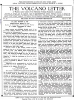
Jaggar, T. A., 1927, The Aleutian Islands: The Volcano Letter, v. 116, p. 1.
Hard Copy held by AVO at FBKS - CEC file cabinet
Grewingk, Constantine, 1850, Grewingk's geology of Alaska and the Northwest Coast of America [edited by Marvin W. Falk, translation by Fritz Jaensch published 2003]: Rasmuson Library Historical Translation Series 11, Fairbanks, AK, The University of Alaska Press, 242 p.
Hard Copy held by AVO at FBKS - CEC shelf
Coats, R. R., Past volcanic activity in the Aleutian arc: U.S. Geological Survey Volcano Investigations Report 1, 18 p.
Hard Copy held by AVO at FBKS - CEC file cabinet
Moran, S.C., Neal, C.A., and Murray, T.L., The U.S. Geological Survey
Volcano Science Center’s Response Plan for Significant Volcanic Events:
U.S. Geological Survey Circular 1518, 65 p. https://doi.org/10.3133/
cir1518