Gareloi

MarkerMarkerMarkerMarkerMarkerMarkerMarkerMarkerMarkerMarkerMarkerMarkerMarkerMarkerMarkerMarkerMarkerMarkerMarkerMarkerMarkerMarkerMarkerMarkerMarkerMarkerMarkerMarkerMarkerMarkerMarkerMarkerMarkerMarkerMarkerMarkerMarkerMarkerMarkerMarkerMarkerMarkerMarkerMarkerMarkerMarkerMarkerMarkerMarkerMarkerMarkerMarkerMarkerMarkerMarkerMarkerMarkerMarkerMarkerMarkerMarkerMarkerMarkerMarkerMarkerMarkerMarkerMarkerMarkerMarkerMarkerMarkerMarkerMarkerMarkerMarkerMarkerMarkerMarkerMarkerMarkerMarkerMarkerMarkerMarkerMarkerMarkerMarkerMarkerMarkerMarkerMarkerMarkerMarkerMarkerMarkerMarkerMarkerMarkerMarkerMarkerMarkerMarkerMarkerMarkerMarkerMarkerMarkerMarkerMarkerMarkerMarkerMarkerMarkerMarkerMarkerMarkerMarkerMarkerMarkerMarkerMarkerMarkerMarkerMarkerMarkerMarkerMarkerMarkerMarkerMarkerMarkerMarkerMarkerMarkerMarkerMarkerMarkerMarkerMarkerMarkerMarkerMarkerMarkerMarkerMarkerMarkerMarkerMarkerMarkerMarkerMarkerMarkerMarkerMarkerMarkerMarkerMarkerMarkerMarkerMarkerMarkerMarkerMarkerMarkerMarkerMarkerMarkerMarkerMarkerMarkerMarkerMarkerMarkerMarkerMarkerMarkerMarkerMarkerMarkerMarkerMarkerMarkerMarkerMarkerMarkerMarkerMarkerMarkerMarkerMarkerMarkerMarkerMarkerMarkerMarkerMarkerMarkerMarkerMarkerMarkerMarkerMarkerMarkerMarkerMarkerMarkerMarkerMarkerMarkerMarker
Legend
Red (Warning)
Orange (Watch)
Yellow (Advisory)
Green (Normal)
Uninstrumented
Community
Webcam
Instrument
Earthquake Magnitude
0 7+
Earthquake Age
Last 2 Hours
Last 2 Days
Last 1 Week


Facts


  • Official Name: Mount Gareloi
  • Seismically Monitored: Yes
  • Color Code: GREEN
  • Alert Level: NORMAL
  • Elevation: 1573m (5160ft)
  • Latitude: 51.78887
  • Longitude: -178.79368
  • Smithsonian VNum: 311070
  • Nearby Towns:
    • Adak 93 mi (149 km) NE
    • Atka 197 mi (318 km) NE
    • Shemya Station 307 mi (494 km) NW
    • Attu Station 345 mi (556 km) NW
    • Nikolski 426 mi (685 km) NE

    Distance from Anchorage: 1265 mi (2035 km)

Description

From Miller and others (1998) [1] : "Mount Gareloi, which makes up most of Gareloi Island, is a stratovolcano 10 km by 8 km in diameter at its base with two summits, separated by a narrow saddle. Two small glaciers extend northwest and southeast from the saddle. The northern, slightly higher peak is on the southern rim of a crater about 300 m across, which contains several active fumaroles. Thirteen younger craters, from 80 to 1600 m in diameter, are aligned along a south-southeast trending fissure that extends from strandline to the southern summit. These craters formed during a major explosive eruption in 1929 that also produced four blocky lava flows (unit Ql), and a blanket of glassy andesitic tuff that covers an area roughly 2.5 x 5 km on the volcano's southeast flank [2] .
"The intercalated lava flows and pyroclastic debris that make up Gareloi volcano were produced during two periods of activity separated by an extended interval of quiescence and erosion. Lava flows range from 1 m to more than 6 m in thickness; some flows of the older sequence appear to have originated from flank vents rather than from the summit. Some valleys cut in older rocks are U-shaped, suggesting that the older series is of late Pleistocene age or older. Rocks of the younger series are relatively undissected; many appear to have been erupted form at or near the summit crater. Craters formed during the 1929 eruptions are probably only partly of phreatic origin; erupted material included essential, pumiceous glass, and reddened scoria. Lava flows that erupted in 1929 emerged at elevations below 600 m. In 1949, one crater at an elevation of 900 m, contained a small, milky blue-green lake, which suggests that acid fumaroles were still active in the crater at that time (Coats, 1959 [2] , p. 253)."

Name Origin

Mount Gareloi is named after Gareloi Island. Gareloi Island's name was published as "O[strov] Goreloi," or "Goreloi Island" by Lt. Sarychev (1826), from the Russian word for "burnt" or "burning." According to Captain Tebenkov (1852), its Unangam Tunuu name was "Anangusik." The name "Gareloi" appeared on U.S. and British maps prior to 1902 (Orth, 1971).


References Cited

[1] Catalog of the historically active volcanoes of Alaska, 1998

Miller, T. P., McGimsey, R. G., Richter, D. H., Riehle, J. R., Nye, C. J., Yount, M. E., and Dumoulin, J. A., 1998, Catalog of the historically active volcanoes of Alaska: U.S. Geological Survey Open-File Report 98-0582, 104 p.

[2] Geologic reconnaissance of Gareloi Island, Aleutian Islands, Alaska, 1959

Coats, R. R., 1959, Geologic reconnaissance of Gareloi Island, Aleutian Islands, Alaska: in Investigations of Alaskan volcanoes, U.S. Geological Survey Bulletin 1028-J, p. 249-256, 1 sheet, scale unknown.
full-text PDF 4.4 MB
plate 33 PDF 1.4 MB

Current Activity

No new updates for Gareloi volcano since March 5, 2024, 11:50 am.

Webcams

Webicorder

Color Code Timeline

Reported Activity

Modern Eruptions

Gareloi

Gareloi Eruption Timeline

Grewingk (1850, translated 2003 by Fritz Jaensch), pg. 121, states Gareloi was active in 1760. Page 122 states that Gareloi was smoking in 1760.

Grewingk (1850, translated 2003 by Fritz Jaensch) states that Sarychev passed Gareloi on the twenty-fourth of September, 1790 and on June 17, 1791 and described Gareloi as a "very tall, snow-covered, fire-belching mountain." It is uncertain if an eruption was observed on either or both of these occasions. The English translation of Sarychev (translated from Russian in 1806 and 1807, republished 1969) makes no mention of "fire-belching" and instead simply states that Gareloi was covered in "eternal snow." Coats (1950): reports minor explosive activity at Gareloi in 1790. Petroff (1884), Becker (1898), and Dall (1870) make no mention of this dubious eruption.
Sauer's account (1802) of the same voyage that Sarychev was on does mention Gareloi on the 24th of September, 1790, and June 17, 1791, but makes no mention of volcanic activity.

Coats (1950): minor explosive activity at Gareloi in 1791. Grewingk (1850, translated 2003 by Fritz Jaensch) states that Sarychev passed Gareloi on the twenty-fourth of September, 1790 and on June 17, 1791 and described Gareloi as a "very tall, snow-covered, fire-belching mountain." It is uncertain if an eruption was observed on either or both of these occasions. Petroff (1884), Becker (1898), and Dall (1870) make no mention of this eruption.

Grewingk (1850, translated 2003 by Fritz Jaensch): Gareloi "belching fire until the end of May" and smoking during 1792.

Gareloi 1828

1828 — 1829

Grewingk (1850, translated 2003 by Fritz Jaensch): Gareloi smoking during 1828. Grewingk (1850, translated 2003 by Fritz Jaensch) also states that Gareloi was smoking during 1829. Miller and others (1998) combined these citations to make one eruption from 1828 until 1829. Simkin and Siebert (1994) reference only the 1829 eruption.

Becker (1898) reports Gareloi active in 1873.

Coats (1950) reports a major explosive eruption at Gareloi in 1922.

Jaggar (1927) writes that Gareloi is "always fuming." and Jaggar (1928) writes that he visited Gareloi and Bogoslof volcanoes and that Gareloi was "sending up dense yellow fumes from its summit crater-cup."

Gareloi 1929/4

April 1929 — 1930

Coombs and others (2008) provide information about the 1929 eruption as follows: "The 1929 eruption is the largest historical eruption of Gareloi and also unique in its eruptive style and composition. The most detailed description of the eruption is given by oats (1959) who summarized the first-hand observations of William H. Dirks, Sr. (Coats, 1959; p. 2): 'In April of 1929, there was an eruption. A terrible quake * * * split the mountain from its crater right to the beach. Ashes fell, completely covering their cabins and boats* * * '
"Coats further elaborated on the series of events from observations of the deposits, which were 17 years old when he visited the island and still unmodified either by vegetation or further eruptive activity. According to Coats, the eruption excavated 13 explosion craters, ranging in diameter from 80 to 1,600 m, along a 4.3-km-long, south-southeast trending fissure [see figs. 5 and 7 in original text]. On the basis of work by Coats (1959) and our fieldwork, the eruption began with formation of the current South Peak crater and a possible directed blast to the south. Following this, an explosive eruption covered the southern half of the island in several meters of tephra fall [see fig. 8 in original text]. At this time, the upper craters were excavated. Small pyroclastic flow deposits are interbedded with tephra-fall deposits, indicating that pyroclastic flows accompanied tephra fall.
"During the second half of the eruption, the composition of the juvenile clasts in the fall deposits became more mafic; craters formed lower on the flank, and small lava flows effused from them. Sometime after explosive activity ceased, debris flows from the summit carried hydrothermally altered blocks down the volcano's southern slope.
"The eruption's total volume is unknown, as much of the ejecta were deposited offshore. Onland pyroclastic deposits represent about 16,000 cubic m, and that of lava is about 2,500 cubic m."

Miller and others (1998), also summarize Coats (1956): "In April of 1929, a phreatic eruption opened an elongate crater 1600 m in maximum diameter just below the southern summit; further explosions produced 12 smaller craters aligned along a south- to southeast-trending fissure. Glassy pumice, lapilli, scoria, and accidental rocks were then ejected from the lower craters, blanketing an area roughly 2.5 by 5 km on the southeast slope. Ash layers up to 2 m thick on Ogliuga Island, located about 16 km southeast, may be attributable at least in part to this eruption (Coats, 1956, p. 92) and several centimeters of pyroclastic debris are known to have fallen on Atka Island (about 300 km eastward) during the event. Extrusion of lava, which formed short steep flows, occurred at four sites along the fissure after the tephra eruptions. Various metallic oxides and halides (including atacamite, paratacamite and hematite) were deposited in several of the lower craters. Activity may have continued into 1930.
"Juvenile material erupted in 1929 may be significantly more siliceous than the older basaltic or basaltic andesite rocks. The lava was apparently highly viscous and generally formed blocky, vesicular, or scoriaceous flows, one of which is 75 m wide and 15 m thick. Orthopyroxene, brown hornblende, plagioclase (average composition about An48), and clinopyroxene were observed in lava flows and pyroclastics of the 1929 eruption (Coats, 1959, p. 254-255)."

Finch (1931): "Gareloi volcano, a peak 5,334 feet high far to the west in the Aleutian Islands, was very active during the spring and summer of 1930. The appearance of half of the island was said to be changed by lava flows from fissures, and a hut was destroyed belonging to fox farmers."

Jaggar (1932): "Gareloi in the western Aleutians was said to erupt so violently in 1930 as to change its appearance by lava flows from fissures."

Loading

Gareloi 1950

1950 — 1951

Jones (1951) reports that minor ash showers and fume emissions occurred during 1951 from Gareloi. Simkin and Siebert (1994) report that this eruption began in 1950 and continued until 1951. Jones (1952) reports that Gareloi was "weakly active during 1950," and "quieter during 1951."
A May 3, 1950 Fairbanks Daily News article suggests that at least some of this activity was not an eruption: "Rear Admiral F.D. Wagner, USN, commander, Alaskan sea frontier, has received information from a naval vessel, the USS Bagaduce, that the volcano on Gareloi island, about 60 miles west of Adakin the Aleutians appears to be active. The Bagaduce sighted large vapor clouds rising to seven thousand feet and drifting southeast at that level."

Gareloi 1952/1

January 17, 1952

Jones (1952) reports that on January 17th, 1952, "a column of grayish-brown fume was rising from the crater on the summit of Gareloi volcano."

Gareloi 1980/8

August 7, 1980 — September 17, 1980

Coombs and others (2008) summarize the 1980 eruption: "On August 8, the crew of a Northwest Orient Airlines plane spotted a plume of ash that rose 35,000-40,000 ft above sea level (Anchorage Times, August 16, 1980, p. A3). David Evans of the USGS reported earthquakes whose epicenters were west of the Adak seismic network on August 8 and 9. Ash fall was not reported at Adak. Cloud cover mostly obscured further observations after August 10, although a photograph of the summit from August 13 shows a light-gray plume rising from the North Peak crater [see fig. 9 in original text]. Evans said, 'As far as we know, there was no lava eruption' (Anchorage Times, August 16, 1980, p. A3). On August 10, airborne stratospheric sampling detected ash and elevated sulfate concentrations between 54 degrees N and 60 degrees N and 150 degrees W (about 2,000 km away) at an altitude of 63,000 ft asl (Sedlacek and others, 1981). On the basis of wind direction and NOAA-6 satellite imagery, the plume was a plausible product of the August 8 eruption (Sedlacek and others, 1981). The Smithsonian reported renewed ash emissions to 6 km asl in September 1980."

Loading

Gareloi 1982/1

January 15, 1982

From Miller and others (1998): "On January 14, 1982, a magnitude 3.2-3.3 earthquake struck the area; the following day, January 15, a 7-9 km eruption cloud was observed on satellite imagery (Smithsonian Institution, 1982)."
Smithsonian Institution (1982), SEAN v. 07, n. 02: "02/82 (SEAN 07:02) Large plume seen on satellite imagery

Gareloi 1987/9

September 4, 1987

From Miller and others (1998):"On September 4, 1987, a commercial pilot observed a narrow flow-like feature on the east flank that extended from the north crater rim at 1500 m altitude down to at least 1100 m, below which it was obscured by clouds. Steam rose 100 m above the flow (?) and the crater was vigorously steaming (Smithsonian Institution, 1987)."
Coombs and others (2008) note "A similar feature was observed from afar during field work in 2003 but we were unable to determine whether it was lava or debris flow."

Gareloi 1989/8

August 17, 1989

From Reeder (1992): "At 1430 on August 17, 1989, Evan Klett of the U.S. Fish and Wildlife observed from the Reeve Aleutian Airways Inc. 727 Boeing Jet, flying from Shemay Island to Adak Island, a grayish to black tephra plume that was about 700 m above the northern near summit crater of Gareloi volcano. The plume covered the top of the 400 m by 260 m near summit crater, which prevented Evan from seeing into the crater. The tephra plume was definitely originating from the summit crater."

Gareloi 1996/9

September 27, 1996

From the Smithsonian Institution (1996): "On 27 September the Aviation Weather Unit in Alaska received a pilot report of a minor eruption of ash and steam at Gareloi. The plume reportedly rose to 1,500 m altitude but was not visible on infrared satellite imagery suggesting it may have not ascended that high. As late as 5 December AVO had learned of no further sightings of activity at Gareloi."

Gareloi 2013/7

July 30, 2013

From Dixon and others (2015): "In July and August [2013], AVO duty personnel responded to observations from a USFWS crew conducting ornithology work on Gareloi Island. The initial reports were of 'tremors of a magnitude that were noticeable to crews working outside, moving around.' A check of the seismicity showed no unusual activity. The background activity at Gareloi, since seismic station installation in 2003, has been constant low-level seismicity consisting of low-frequency earthquakes at a rate of one per minute. In light of the 2008 evacuation of a USFWS crew at Kasatochi and the subsequent eruption of Kasatochi (Waythomas and others, 2010), AVO closely monitored seismicity at Gareloi during the late summer. Despite close scrutiny, no changes were noted in the seismicity, nor were there further observations of felt events. Although the cause of the felt earthquakes was not determined, the felt reports were forwarded to AVO offices a week after a July 7 ML=5.5 earthquake and aftershock sequence south of Gareloi. The felt reports did not include event timing, and the most plausible explanation is that the USFW crew felt regional earthquakes and not volcano-related seismicity.
"The USFW crew also noted 'steam coming from the extensive fumarole area on the west peak' on July 30. Although this was a single observation, the field crew additionally commented that the weather on July 30 was unusually clear and allowed for the observation of steaming (fig. 47 in original text). Steaming at fumaroles on Gareloi is routinely seen, with observations of steaming in 2003 and 2005 (Michelle Coombs, USGS/AVO, written commun., 2005)."

Gareloi 2018/06

June 1, 2018 — September 30, 2018

From Cameron and others, 2023: "The typical seismicity of Mount Gareloi is characterized by many low-frequency earthquakes that are commonly too small to be located by its seismic network, which comprises six stations on Gareloi Island and nearby Kavalga Island. Although the frequency of located seismic events varied in the past, seismicity at Mount Gareloi was fairly constant in recent years: 265 earthquakes were located in 2016 and 269 were located in 2017. In the summer of 2018, however, AVO located an anomalously high number of earthquakes, with 190 located in June and 178 in July. AVO then located 80 earthquakes in August and 77 in September before the volcano returned to typical activity levels in the fall. This period of increased activity was dominated by low-frequency earthquakes at depths of 5–15 km, which is typical for seismicity at Mount Gareloi. AVO paid close attention to the elevated seismicity rates but kept the Aviation Color Code and Volcano Alert Level at GREEN and NORMAL.
"In 2022, while retrospectively reviewing high-resolution satellite imagery of Mount Gareloi, AVO found a 2018 image showing an approximately 5-kilometer-long ash deposit extending north-northwest from the south fumarole field of the volcano. This image, taken by the WorldView-2 satellite on June 12, appears to record a previously unrecognized small ash emission (eruption). Satellite imagery acquired by Planet Labs PBC first shows the ash streak on June 6; the actual emission may have taken place on June 5."

Loading

Gareloi 2021 unrest

May 18, 2021 — July 28, 2021

From Orr and others, 2024: "Beginning on May 18, 2021, anomalous seismicity was recorded at the Mount Gareloi. In particular, the low-energy LP events commonly observed at the volcano overlapped with a harmonic tremor recorded on every station on the island. The dominant tremor frequencies peaked at ~3.4 hertz (Hz), ~6.4 Hz, ~8.3 Hz, and ~10.7 Hz. These harmonic signals, which were intermittent during at least the previous day, became conspicuous after a regional ML 5.0 earthquake at 20:42 HADT on May 17 (05:42 UTC on May 18), though this change might be coincidental. Harmonic tremor took place intermittently until May 27, when highly frequent and highly energetic LP events emerged, sometimes merging into continuous broadband tremor. An ~2-Hz infrasound signal was also recorded locally on June 3, although it was unclear if the signal was of volcanic origin. A monochromatic, ~7 Hz seismic signal lasting 15-20 min was recorded on June 6, while elevated-amplitude seismicity, ongoing since about May 27, continued. Hence, on June 8, AVO raised the Aviation Color Code and Volcano Alert Level to YELLOW and ADVISORY. The increase in seismic activity likely reflected a change to the magmatic-hydrothermal system interaction. No indications of unrest, however, were observed by an AVO field crew that flew over the summit on May 23.
"Over the following two months, the elevated and anomalous seismicity continued intermittently; SO2 was detected in satellite imagery but was consistent with measurements from the last several years; light steaming was observed in partly cloudy satellite and webcam views of the volcano; and weakly elevated surface temperatures were sometimes observed in satellite data. No eruptive activity was observed in satellite views of the volcano and no activity was detected by local or regional infrasound sensors. Starting in the second week of July, seismic activity gradually diminished and returned to background levels. AVO lowered the Aviation Color Code and Volcano Alert Level to GREEN and NORMAL on July 28, 2021."

Loading

Gareloi unrest 2024

February 12, 2024 — March 5, 2024

On February 12, 2024, at 1:10 PM AKST, AVO raised the alert levels at Gareloi to YELLOW/ADVISORY, stating: "Over the past several hours, AVO has detected an increase in seismicity at Mount Gareloi (Gareloi volcano) beginning at 09:15 AKST (18:15 UTC). The current activity marks a change in character above background rates...There have been no other notable changes at the volcano in satellite data or webcam views. Mount Gareloi persistently emits magmatic gases from a fumarole field on the south crater and commonly exhibits low-level seismic activity. These observations suggest the presence of shallow magma and potential interaction with a hydrothermal system. The current increase in seismicity likely reflects a change to the magmatic-hydrothermal system, but it is not clear that the likelihood of a volcanic eruption has increased."
In the week afterward, seismicity remained elevated, with numerous earthquakes and volcanic tremor. In the following week, seismicity did decrease somewhat, while remaining somewhat above background levels. Steaming was frequently observed, but this is not abnormal at Gareloi.
On March 5, 2024, AVO returned the alert levels to GREEN/NORMAL, stating that seismicity had returned to background levels.

Gareloi 1760

Gareloi 1790

Gareloi 1791

Gareloi 1792

Gareloi 1828

Gareloi 1873

Gareloi 1922

Gareloi 1927

Gareloi 1929/4

Gareloi 1950

Gareloi 1952/1

Gareloi 1980/8

Gareloi 1982/1

Gareloi 1987/9

Gareloi 1989/8

Gareloi 1996/9

Gareloi 2013/7

Gareloi 2018/06

Gareloi 2021 unrest

Gareloi unrest 2024

1000
1100
1200
1300
1400
1500
1600
1700
1800
1900
2000
2100
2200
2300
2400
2500
1690
1710
1720
1730
1740
1750
1760
1770
1780
1790
1810
1820
1830
1840
1850
1860
1870
1880
1890
1910
1920
1930
1940
1950
1960
1970
1980
1990
2010
2020
2030
2040
2050
2060
2070
2080

20 Event Date(s)

Past Activity Legend:
Eruption
Questionable eruption
Non-eruptive activity


Showing 1 - 20 of 119

Map Images


Map References


Recently active volcanoes of Alaska, 2023

Cameron, C.E., Bull, K.F., and Macpherson, A.E., 2023, Recently active volcanoes of Alaska: Alaska Division of Geological & Geophysical Surveys Miscellaneous Publication 133 v. 6, 2 sheets. https://doi.org/10.14509/31086.

Historically active volcanoes of Alaska, v. 3, 2018

Cameron, C.E., Schaefer, J.R., and Mulliken, K.M., 2018, Historically active volcanoes of Alaska: Alaska Division of Geological & Geophysical Surveys Miscellaneous Publication 133 v. 3, 2 sheets. Http://doi.org/10.14509/30142

Historically active volcanoes of Alaska, 2014

Schaefer, J.R., Cameron, C.E., and Nye, C.J., 2014, Historically active volcanoes of Alaska: Alaska Division of Geological & Geophysical Surveys Miscellaneous Publication 133 v. 1.2, 1 sheet, scale 1:3,000,000. This publication has been superseded. Newest version available at http://www.dggs.alaska.gov/pubs/id/20181 .

Geologic map of Mount Gareloi, Gareloi Island, Alaska, 2012

Coombs, M.L., McGimsey, R.G., and Browne, B.L., 2012, Geologic map of Mount Gareloi, Gareloi Island, Alaska: U.S. Geological Survey Scientific Investigations Map 3145, 18 p., 1 sheet, scale 1:24,000, available at http://pubs.usgs.gov/sim/3145/ .

Digital data for the reconnaissance geologic map of the western Aleutian islands, Alaska, 2006

Wilson, F.H., Mohadjer, Solmaz, Labay, K.A., Shew, Nora, and Grey, D.M., 2006, Digital data for the reconnaissance geologic map of the western Aleutian islands, Alaska: U.S. Geological Survey Open-File Report 2006-1302, 1 p., available online at http://pubs.usgs.gov/of/2006/1302/

Historically active volcanoes of the Aleutian Arc, 2002

Schaefer, Janet, and Nye, C. J., 2002, Historically active volcanoes of the Aleutian Arc: Alaska Division of Geological & Geophysical Surveys Miscellaneous Publication MP 0123, unpaged, 1 sheet, scale 1:3,000,000. Superceded by Miscellaneous Publication 133: http://www.dggs.dnr.state.ak.us/pubs/pubs?reqtype=citation&ID=20181

Volcanoes of Alaska, 1998

Nye, C. J., Queen, Katherine, and McCarthy, A. M., 1998, Volcanoes of Alaska: Alaska Division of Geological & Geophysical Surveys Information Circular IC 0038, unpaged, 1 sheet, scale 1:4,000,000, available at http://www.dggs.dnr.state.ak.us/pubs/pubs?reqtype=citation&ID=7043 .
Hard Copy held by AVO at FBKS - CEC shelf

Volcanoes of Alaska, 1995

Alaska Division of Geological & Geophysical Surveys, 1995, Volcanoes of Alaska: Alaska Division of Geological & Geophysical Surveys Information Circular IC 0038, unpaged, 1 sheet, scale 1:4,000,000.

Aleutian arc volcanoes, 1994

Nye, C. J., 1994, Aleutian arc volcanoes: Alaska Division of Geological & Geophysical Surveys Public-Data File PDF 94-54, unpaged, 1 sheet, scale 1:2,126,841.

Geothermal resources of the Aleutian Arc, 1993

Motyka, R. J., Liss, S. A., Nye, C. J., and Moorman, M. A., 1993, Geothermal resources of the Aleutian Arc: Alaska Division of Geological & Geophysical Surveys Professional Report PR 0114, 17 p., 4 sheets, scale 1:1,000,000.
Hard Copy held by AVO at FBKS - CEC shelf

Holocene volcanoes of the Aleutian Arc, Alaska, 1993

March, G. D., 1993, Holocene volcanoes of the Aleutian Arc, Alaska: Alaska Division of Geological & Geophysical Surveys Public-Data File PDF 93-85, unpaged, 1 sheet, scale 1:2,000,000.

Map showing distribution, composition, and age of Late Cenozoic volcanic centers in Alaska, 1986

Luedke, R. G., and Smith, R. L., 1986, Map showing distribution, composition, and age of Late Cenozoic volcanic centers in Alaska: U.S. Geological Survey Miscellaneous Investigations Series Map I 1091-F, unpaged, 3 sheets, scale 1:1,000,000.

Geologic reconnaissance of Gareloi Island, Aleutian Islands, Alaska, 1959

Coats, R. R., 1959, Geologic reconnaissance of Gareloi Island, Aleutian Islands, Alaska: in Investigations of Alaskan volcanoes, U.S. Geological Survey Bulletin 1028-J, p. 249-256, 1 sheet, scale unknown.
full-text PDF 4.4 MB
plate 33 PDF 1.4 MB
Hard Copy held by AVO at FBKS - CEC shelf

Geology of the Delarof and westernmost Andreanof Islands, Aleutian Islands, Alaska, 1959

Fraser, G. D., and Barnett, H. F., 1959, Geology of the Delarof and westernmost Andreanof Islands, Aleutian Islands, Alaska: in Investigations of Alaskan volcanoes, U.S. Geological Survey Bulletin 1028-I, p. 211-248, 4 sheets, scale 3 at 1:25,000, and 1 at 1:250,000.
full-text PDF 1.2 MB
plate 27 PDF 3.6 MB
plate 28 PDF 1.5 MB
plate 29 PDF 1.3 MB
plate 30 PDF 1.3 MB
Hard Copy held by AVO at FBKS - CEC shelf

Geology of southern Adak Island and Kagalaska Island, Alaska, 1959

Fraser, G. D., and Snyder, G. L., 1959, Geology of southern Adak Island and Kagalaska Island, Alaska: in Investigations of Alaskan volcanoes, U.S. Geological Survey Bulletin 1028-M, p. 371-408, 2 sheets, scale 1:125,000.
full-text PDF 4.7 MB
plate 52 PDF 2.6 MB
plate 53 PDF 1.9 MB
Hard Copy held by AVO at FBKS - CEC shelf

Reconnaissance geology of some western Aleutian Islands, Alaska, 1956

Coats, R. R., 1956, Reconnaissance geology of some western Aleutian Islands, Alaska: in Investigations of Alaskan volcanoes, U.S. Geological Survey Bulletin 1028-E, p. 83-100, 1 sheet, scale unknown.
full-text PDF 4.4 MB
plate 17 PDF 1.6 MB

Volcanic activity in the Aleutian Arc, 1950

Coats, R. R., 1950, Volcanic activity in the Aleutian Arc: U.S. Geological Survey Bulletin 0974-B, p. 35-49, 1 sheet, scale 1:5,000,000.
plate 1 PDF 819 KB
full-text PDF 783 KB
Hard Copy held by AVO at FBKS - CEC shelf

Reconnaissance of the gold fields of southern Alaska with some notes on general geology, 1898

Becker, G. F., 1898, Reconnaissance of the gold fields of southern Alaska with some notes on general geology: U.S. Geological Survey Annual Report 0018, p. 1-86, 6 sheets, scale unknown.
full-text PDF 1.5 MB
Hard Copy held by AVO at FBKS - CEC file cabinet

References

2021 Volcanic activity in Alaska and the Commonwealth of the Northern Mariana Islands - Summary of events and response of the Alaska Volcano Observatory, 2024

Orr, T.R., Dietterich, H.R., Fee D., Girona, T., Grapenthin, R., Haney, M.M., Loewen, M.W., Lyons, J.J., Power, J.A., Schwaiger, H.F., Schneider, D.J., Tan, D., Toney, L., Wasser, V.K., and Waythomas, C.F., 2024, 2021 Volcanic activity in Alaska and the Commonwealth of the Northern Mariana Islands - Summary of events and response of the Alaska Volcano Observatory: U.S. Geological Survey Scientific Investigations Report 2024-5014, 64 p. https://doi.org/10.3133/sir20245014.
Full-text PDF 25.7 MB

Deformation mapping and modeling of the Aleutian volcanoes with InSAR and numerical models, 2024

Wang, J., 2024, Deformation mapping and modeling of the Aleutian volcanoes with InSAR and numerical models: University Park, Tex., Southern Methodist University, Ph.D. dissertation, 143 p.
Full-text PDF 8.4 MB

Mechanisms of magmatic degassing and eruption triggering at Alaska volcanoes - experimental controls and natural system analogues, 2024

Graham, N.A., 2024, Mechanisms of magmatic degassing and eruption triggering at Alaska volcanoes: experimental controls and natural system analogues: Fairbanks, Alaska, University of Alaska Fairbanks, Ph.D. dissertation, 307 p.

Bulk compositions of western Aleutians tephras and lavas collected during leg 3 of the NSF GeoPRISMS shared platform for Aleutians research, Version 1.0, 2024

Andrys, J. L., Coombs, M. L., Cottrell, E., Kelley, K. A., Waters, L. E., and Jicha, B., 2024, Bulk compositions of western Aleutians tephras and lavas collected during leg 3 of the NSF GeoPRISMS shared platform for Aleutians research, Version 1.0: Interdisciplinary Earth Data Alliance (IEDA). https://doi.org/10.60520/IEDA/113465.

Recently active volcanoes of Alaska, 2023

Cameron, C.E., Bull, K.F., and Macpherson, A.E., 2023, Recently active volcanoes of Alaska: Alaska Division of Geological & Geophysical Surveys Miscellaneous Publication 133 v. 6, 2 sheets. https://doi.org/10.14509/31086.

Probabilistic source classification of large tephra producing eruptions using supervised machine learning - an example from the Alaska-Aleutian Arc, 2023

Lubbers, J., Loewen, M., Wallace, K., Coombs, M., and Addison, J., 2023, Probabilistic source classification of large tephra producing eruptions using supervised machine learning - an example from the Alaska-Aleutian Arc: Geochemistry, Geophysics, Geosystems v. 24, no. 11, e2023GC011037. https://doi.org/10.1029/2023GC011037.

Along-arc volcanism in the western and central Aleutian from 2015 to 2021 revealed by cloud-based InSAR processing, 2023

Wang, J., Lu, Z., Bekaert, D., Marshak, C., Govorcin, M., Sangha, S., Kennedy, J., and Gregg, P., 2023, Along-arc volcanism in the western and central Aleutian from 2015 to 2021 revealed by cloud-based InSAR processing: Geophysical Research Letters v. 50, no. 23, e2023GL106323. https://doi.org/10.1029/2023GL106323
Full-text PDF 3.9 MB

Alaska interagency operating plan for volcanic ash episodes, 2022

Alaska Volcano Observatory, National Oceanic and Atmospheric Administration, National Weather Service, Federal Aviation Administration, Department of Defense, United States Coast Guard, Division of Homeland Security and Emergency Management, Alaska Department of Environmental Conservation, and Alaska Department of Health and Social Services (participating agencies), 2022, Alaska interagency operating plan for volcanic ash episodes, 85 p.

To erupt or not to erupt? That is the question: Extremely high levels of background seismicity and lack of eruptivity from 2003-2019 at Gareloi Volcano, Aleutian Islands, Alaska, 2022

Harris, K.T., 2022, To erupt or not to erupt? That is the question: Extremely high levels of background seismicity and lack of eruptivity from 2003-2019 at Gareloi Volcano, Aleutian Islands, Alaska: Bellingham, Western Washington University, Masters thesis, 109 p., 28 figs.

Geologic database of information on volcanoes in Alaska (GeoDIVA), 2022

Cameron, C.E., Crass, S.W., and AVO Staff, eds, 2022, Geologic database of information on volcanoes in Alaska (GeoDIVA): Alaska Division of Geologic and Geophysical Surveys Digital Data Series 20, https://doi.org/10.14509/geodiva, https://doi.org/10.14509/30901.

Western Aleutian volcanism; Defining magmatic series transitions and petrogenic origins, 2022

Oxhorn, S., 2022, Western Aleutian volcanism; Defining magmatic series transitions and petrogenic origins: Athens, G.A., University of Georgia, M.S. thesis, 161 p.

Quantifying eruptive and background seismicity, deformation, degassing, and thermal emissions at volcanoes in the United States during 1978-2020, 2021

Reath, K., Pritchard, M.E., Roman, D.C., Lopez, T., Carn, S., Fischer, T.P., Lu, Z., Poland, M.P., Vaughan, R.G., Wessels, R., Wike, L.L., and Tran, H.K., 2021, Quantifying eruptive and background seismicity, deformation, degassing, and thermal emissions at volcanoes in the United States during 1978-2020: Journal of Geophysical Research: Solid Earth, v. 126, e2021JB021684, doi: 10.1029/2021JB021684.

Gas emissions from the Western Aleutians volcanic arc, 2021

Fischer, T.P., Lopez, T.M., Aiuppa, Alessandro, Rizzo, A.L., Ilanko, Tehnuka, Kelley, K.A., and Cottrell, Elizabeth, 2021, Gas emissions from the Western Aleutians volcanic arc: Frontiers in Earth Science, v. 9., 10.3389/feart.2021.786021.

Goals and development of the Alaska Volcano Observatory seismic network and application to forecasting and detecting volcanic eruptions, 2020

Power, J.A., Haney, M.M., Botnick, S.M., Dixon, J.P., Fee, David, Kaufman, A.M., Ketner, D.M., Lyons, J.J., Parker, Tom, Paskievitch, J.F., Read, C.W., Searcy, Cheryl, Stihler, S.D., Tepp, Gabrielle, and Wech, A.G., 2020, Goals and development of the Alaska Volcano Observatory seismic network and application to forecasting and detecting volcanic eruptions: Seismological Research Letters, doi: 10.1785/0220190216 .

Historically active volcanoes of Alaska, v. 4, 2020

Cameron, C.E., Schaefer, J.R., and Ekberg, P.G., 2020, Historically active volcanoes of Alaska: Alaska Division of Geological & Geophysical Surveys Miscellaneous Publication 133 v. 4, 2 sheets. Http://doi.org/10.14509/30426

2017 Volcanic activity in Alaska-Summary of events and response of the Alaska Volcano Observatory, 2020

Dixon, J.P., Cameron, C.E., Iezzi, A.M., Power, J.A., Wallace, K., and Waythomas, C.F., 2020, 2017 Volcanic activity in Alaska-Summary of events and response of the Alaska Volcano Observatory: U.S. Geological Survey Scientific Investigations Report 2020-5102, 61 p., https://doi.org/10.3133/sir20205102.

Catalog of earthquake parameters and description of seismograph and infrasound stations at Alaskan volcanoes - January 1, 2013, through December 31, 2017, 2019

Dixon, J.P., Stihler S.D., Haney, M.M., Lyons, J.J., Ketner, D.M., Mulliken, K.M., Parker, T., and Power, J.A., 2019, Catalog of earthquake parameters and description of seismograph and infrasound stations at Alaskan volcanoes - January 1, 2013, through December 31, 2017: U.S. Geological Survey Data Series 1115, 92 p., https://doi.org/10.3133/ds1115.

A unified catalog of earthquake hypocenters and magnitudes at volcanoes in Alaska: 1989 to 2018, 2019

Power, J.A., Friberg, P.A., Haney, M.M., Parker, T., Stihler, S.D., and Dixon, J.P., 2019, A unified catalog of earthquake hypocenters and magnitudes at volcanoes in Alaska—1989 to 2018: U.S. Geological Survey Scientific Investigations Report 2019–5037, 17 p., https://doi.org/10.3133/sir20195037.

The Alaska Volcano Observatory: 30 years of protecting Alaskans from the effects of volcanic activity (1988-2018), 2018

Mulliken, K.M., 2018, The Alaska Volcano Observatory: 30 years of protecting Alaskans from the effects of volcanic activity (1988-2018): Alaska Division of Geological & Geophysical Surveys Information Circular 67, 2 p. http://doi.org/10.14509/30032

The influence of tectonic environment on dynamic earthquake triggering: a review and case study on Alaskan volcanoes, 2018

Prejean, S.G., and Hill, D.P., 2018, The influence of tectonic environment on dynamic earthquake triggering: a review and case study on Alaskan volcanoes: Tectonophysics, v. 745, p. 293-304, doi.org/10.1016/j.tecto.2018.08.007.

2018 update to the U.S. Geological Survey national volcanic threat assessment, 2018

Ewert, J.W., Diefenbach, A.K., and Ramsey, D.W., 2018, 2018 update to the U.S. Geological Survey national volcanic threat assessment: U.S. Geological Survey Scientific Investigations Report 2018-5140, 40 p., https://pubs.usgs.gov/sir/2018/5140/sir20185140.pdf.

Historically active volcanoes of Alaska, v. 3, 2018

Cameron, C.E., Schaefer, J.R., and Mulliken, K.M., 2018, Historically active volcanoes of Alaska: Alaska Division of Geological & Geophysical Surveys Miscellaneous Publication 133 v. 3, 2 sheets. Http://doi.org/10.14509/30142

Quantifying arc migration and the role of forearc subduction erosion in the central Aleutians, 2018

Jicha, B.R., and Kay, S.M., 2018, Quantifying arc migration and the role of forearc subduction erosion in the central Aleutians: Journal of Volcanology and Geothermal Research, v, 360, p. 84-99, doi: http://dx.doi.org/10.1016/j.jvolgeores.2018.06.016.

Historically active volcanoes of Alaska, 2016

Cameron, C.E., and Schaefer, J.R., 2016, Historically active volcanoes of Alaska: Alaska Division of Geological & Geophysical Surveys Miscellaneous Publication 133 v. 2, 1 sheet, scale 1:3,000,000. http://doi.org/10.14509/20181

Eocene to Pleistocene magmatic evolution of the Delarof Islands, Aleutian Arc, 2016

Schaen, A.J., Jicha, B.R., Kay, S.M., Singer, B.S., Tibbetts, A., 2016, Eocene to Pleistocene magmatic evolution of the Delarof Islands, Aleutian Arc: Geochemistry, Geophysics, Geosystems, v. 17, n. 3, p. 1086-1108.

2013 Volcanic activity in Alaska - summary of events and response of the Alaska Volcano Observatory, 2015

Dixon, J.P., Cameron, Cheryl, McGimsey, R.G., Neal, C.A., and Waythomas, Chris, 2015, 2013 Volcanic activity in Alaska - Summary of events and response of the Alaska Volcano Observatory: U.S. Geological Survey Scientific Investigations Report 2015-5110, 92 p., http://dx.doi.org/10.3133/sir20155110.

Historically active volcanoes of Alaska, 2014

Schaefer, J.R., Cameron, C.E., and Nye, C.J., 2014, Historically active volcanoes of Alaska: Alaska Division of Geological & Geophysical Surveys Miscellaneous Publication 133 v. 1.2, 1 sheet, scale 1:3,000,000. This publication has been superseded. Newest version available at http://www.dggs.alaska.gov/pubs/id/20181 .

Regional controls on volcano seismicity along the Aleutian Arc, 2014

Buurman, Helena, Nye, C.J., West, M.E., and Cameron, Cheryl, 2014, Regional controls on volcano seismicity along the Aleutian Arc: Geochemistry, Geophysics, Geosystems, doi:10.1002/2013GC005101

Preliminary database of Quaternary vents in Alaska, 2014

Cameron, C.E., and Nye, C.J., 2014, Preliminary database of Quaternary vents in Alaska: Alaska Division of Geological & Geophysical Surveys Miscellaneous Publication 153, 11 p., doi:10.14509/27357 .

InSAR imaging of Aleutian volcanoes, 2014

Lu, Zhong, and Dzurisin, Daniel, 2014, InSAR imaging of Aleutian volcanoes: Chichester, UK, Springer-Praxis, 390 p.

Catalog of earthquake hypocenters at Alaskan volcanoes: January 1 through December 31, 2012, 2013

Dixon, J.P., Stihler, S.D, Power, J.A., Haney, Matt, Parker, Tom, Searcy, C.K., and Prejean, Stephanie, 2013, Catalog of earthquake hypocenters at Alaskan volcanoes: January 1 through December 31, 2012: U.S. Geological Survey Data Series 789, 84 p., available at http://pubs.usgs.gov/ds/789/ .
full-text pdf 6.5 MB

Geologic map of Mount Gareloi, Gareloi Island, Alaska, 2012

Coombs, M.L., McGimsey, R.G., and Browne, B.L., 2012, Geologic map of Mount Gareloi, Gareloi Island, Alaska: U.S. Geological Survey Scientific Investigations Map 3145, 18 p., 1 sheet, scale 1:24,000, available at http://pubs.usgs.gov/sim/3145/ .

Catalog of earthquake hypocenters at Alaskan volcanoes: January 1 through December 31, 2011, 2012

Dixon, J.P., Stihler, S.D., Power, J.A., and Searcy, C.K., 2012, Catalog of earthquake hypocenters at Alaskan volcanoes: January 1 through December 31, 2011: U.S. Geological Survey Data Series 730, 82 p., available online at http://pubs.usgs.gov/ds/730/pdf/ds730.pdf .

Review of crustal seismicity in the Aleutian Arc and implications for arc deformation, 2012

Ruppert, N.A., Kozyreva, N.P., and Hansen, R.A., 2012, Review of crustal seismicity in the Aleutian Arc and implications for arc deformation: Tectonophysics, v. 522-523, p. 150-157, doi:10.1016/j.tecto.2011.11.024 .

Catalog of earthquake hypocenters at Alaskan volcanoes: January 1 through December 31, 2010, 2011

Dixon, J.P., Stihler, S.D., Power, J.A., and Searcy, C.K., 2011, Catalog of earthquake hypocenters at Alaskan volcanoes: January 1 through December 31, 2010: U.S. Geological Survey Data Series 645, 82 p., available online at http://pubs.usgs.gov/ds/645/

Volcano collapse along the Aleutian Ridge (western Aleutian Arc), 2011

Montanaro, C., and Beget, J., 2011, Volcano collapse along the Aleutian Ridge (western Aleutian Arc): Natural Hazards and Earth System Sciences, v. 11, n. 3., p. 715-730, available online at http://www.nat-hazards-earth-syst-sci.net/11/715/2011/nhess-11-715-2011.pdf .
full-text pdf 915 KB

Catalog of earthquake hypocenters at Alaskan volcanoes: January 1 through December 31, 2009, 2010

Dixon, J.P., Stihler, S.D., Power, J.A., and Searcy, C.K., 2010, Catalog of earthquake hypocenters at Alaskan volcanoes: January 1 through December 31, 2009: U.S. Geological Survey Data Series 531, 84 p., available online at http://pubs.usgs.gov/ds/531/ .

Catalog of earthquake hypocenters at Alaskan volcanoes: January 1 through December 31, 2008, 2009

Dixon, J.P., and Stihler, S.D., 2009, Catalog of earthquake hypocenters at Alaskan volcanoes: January 1 through December 31, 2008: U.S. Geological Survey Data Series 467, 88 p., available at http://pubs.usgs.gov/ds/467/ .

Historically active volcanoes of Alaska reference deck, 2009

Snedigar, S.F., and Cameron, C.C., 2009, Historically active volcanoes of Alaska reference deck: Alaska Division of Geological & Geophysical Surveys Information Circular 59, 52 p, available to order from http://www.dggs.dnr.state.ak.us/pubs/pubs?reqtype=citation&ID=20401 .

Chronology and references of volcanic eruptions and selected unrest in the United States, 1980-2008, 2009

Diefenbach, A.K., Guffanti, Marianne, and Ewert, J.W., 2009, Chronology and references of volcanic eruptions and selected unrest in the United States, 1980-2008: U.S. Geological Survey Open-File Report 2009-1118, 85 p., available at http://pubs.usgs.gov/of/2009/1118/ .

Preliminary spreadsheet of eruption source parameters for volcanoes of the world, 2009

Mastin, L.G., Guffanti, Marianne, Ewert, J.E., and Spiegel, Jessica, 2009, Preliminary spreadsheet of eruption source parameters for volcanoes of the world: U.S. Geological Survey Open-File Report 2009-1133, v. 1.2, 25 p., available at http://pubs.usgs.gov/of/2009/1133/ .

Catalog of earthquake hypocenters at Alaskan volcanoes: January 1 through December 31, 2006, 2008

Dixon, J.P., Stihler, S.D., Power, J.A., and Searcy, Cheryl, 2008, Catalog of earthquake hypocenters at Alaskan volcanoes: January 1 through December 31, 2006: U.S. Geological Survey Data Series 326, 79 p., available at http://pubs.usgs.gov/ds/326/ .

The Alaska Volcano Observatory - 20 years of volcano research, monitoring, and eruption response, 2008

Schaefer, J.R., and Nye, Chris, 2008, The Alaska Volcano Observatory - 20 years of volcano research, monitoring, and eruption response: Alaska Division of Geological & Geophysical Surveys, Alaska GeoSurvey News, NL 2008-001, v. 11, n. 1, p. 1-9, available at http://wwwdggs.dnr.state.ak.us/pubs/pubs?reqtype=citation&ID=16061 .

Catalog of earthquake hypocenters at Alaskan volcanoes: January 1 through December 31, 2007, 2008

Dixon, J.P., Stihler, S.D. and Power, J.A., 2008, Catalog of earthquake hypocenters at Alaskan volcanoes: January 1 through December 31, 2007: U.S. Geological Survey Data Series 367, 82 p., available online at http://pubs.usgs.gov/ds/367/ .

Preliminary volcano-hazard assessment for Gareloi Volcano, Gareloi Island, Alaska, 2008

Coombs, M.L., McGimsey, R.G., and Browne, B.L., 2008, Preliminary volcano-hazard assessment for Gareloi Volcano, Gareloi Island, Alaska: U.S. Geological Survey Scientific Investigations Report 2008-5159, 29 p., 1 sheet, available at https://pubs.usgs.gov/sir/2008/5159/.

Massive edifice failure at Aleutian arc volcanoes, 2007

Coombs, M.L., White, S.M., and Scholl, D.W., 2007, Massive edifice failure at Aleutian arc volcanoes: Earth and Planetary Science Letters, v. 256, p. 403-418, doi: 10.1016/j.epsl.2007.01.030.

System for ranking relative threats of U.S. volcanoes, 2007

Ewert, John, 2007, System for ranking relative threats of U.S. volcanoes: Natural Hazards Review, v. 8, n. 4, p. 112-124.

Catalog of earthquake hypocenters at Alaskan volcanoes: January 1 through December 31, 2005, 2006

Dixon, J.P., Stihler, S.D., Power, J.A., Tytgat, Guy, Estes, Steve, and McNutt, S.R., 2006, Catalog of earthquake hypocenters at Alaskan volcanoes: January 1 through December 31, 2005: U.S. Geological Survey Open-File Report 2006-1264, 78 p., available at http://pubs.usgs.gov/of/2006/1264/ .

Digital data for the reconnaissance geologic map of the western Aleutian islands, Alaska, 2006

Wilson, F.H., Mohadjer, Solmaz, Labay, K.A., Shew, Nora, and Grey, D.M., 2006, Digital data for the reconnaissance geologic map of the western Aleutian islands, Alaska: U.S. Geological Survey Open-File Report 2006-1302, 1 p., available online at http://pubs.usgs.gov/of/2006/1302/

March-April 2004, 2005

Alaska Volcano Observatory, 2005, March-April 2004: Alaska Volcano Observatory Bimonthly Report, v.16, n. 2, unpaged.

May-June 2004, 2005

Alaska Volcano Observatory, 2005, May-June 2004: Alaska Volcano Observatory Bimonthly Report, v. 16, n. 3, unpaged.

July-August 2004, 2005

Alaska Volcano Observatory, 2005, July-August 2004: Alaska Volcano Observatory Bimonthly Report, v. 16, n. 4, unpaged.

September-October 2004, 2005

Alaska Volcano Observatory, 2005, September-October 2004: Alaska Volcano Observatory Bimonthly Report, v. 16, n. 5, unpaged.

An assessment of volcanic threat and monitoring capabilities in the United States: framework for a National Volcano Early Warning System NVEWS, 2005

Ewert, J.W., Guffanti, Marianne, and Murray, T.L., 2005, An assessment of volcanic threat and monitoring capabilities in the United States: framework for a National Volcano Early Warning System NVEWS: U.S. Geological Survey Open-File Report 2005-1164, 62 p.
full-text PDF 2.90 MB

March-April 2005, 2005

Alaska Volcano Observatory, 2005, March-April 2005: Alaska Volcano Observatory Bimonthly report, v. 17, n. 2, unpaged, http://www.avo.alaska.edu/avobm/avo_info.php?volume=17&number=2.

Predicting regions susceptible to high concentrations of airborne volcanic ash in the North Pacific region, 2005

Papp, K.P., Dean, K.G., and Dehn, J., 2005, Predicting regions susceptible to high concentrations of airborne volcanic ash in the North Pacific region: Journal of Volcanology and Geothermal Research, v. 148, no. 3-4, p. 295-314, doi: 10.1016/j.jvolgeores.2005.04.020.

Catalog of earthquake hypocenters at Alaskan volcanoes: January 1 through December 31, 2004, 2005

Dixon, J.P., Stihler, S.D., Power, J.A., Tytgat, Guy, Estes, Steve, Prejean, Stephanie, Sanchez, J.J., Sanches, Rebecca, McNutt, S.R., and Paskievitch, John, 2005, Catalog of earthquake hypocenters at Alaskan volcanoes: January 1 through December 31, 2004: U.S. Geological Survey Open-File Report 2005-1312, 74 p., available online at http://pubs.usgs.gov/of/2005/1312/.

January-February 2003, 2004

Alaska Volcano Observatory, 2004, January-February 2003: Alaska Volcano Observatory Bimonthly Report, v. 15, n. 1, unpaged.

July-August 2003, 2004

Alaska Volcano Observatory, 2004, July-August 2003: Alaska Volcano Observatory Bimonthly Report, v. 15, n. 4, unpaged.

September-October 2003, 2004

Alaska Volcano Observatory, 2004, September-October 2003: Alaska Volcano Observatory Bimonthly Report, v. 15, n. 5, unpaged.

2 volcanoes becoming restless, 2004

O'Harra, Doug, 2004, 2 volcanoes becoming restless: Anchorage Daily News, v. June 14, 2004, p. B1, B7.

Preliminary geology of Gareloi Volcano, western Aleutian Islands (Alaska), 2004

Browne, B. L., Coombs, M. L., and Larsen, J. F., 2004, Preliminary geology of Gareloi Volcano, western Aleutian Islands (Alaska) [abs.]: Eos, AGU Fall Meeting Supplement, v. 85, n. 47, p. V43E-1454.

Catalog of earthquake hypocenters at Alaskan volcanoes: January 1 through December 31, 2003, 2004

Dixon, J. P., Stihler, S. D., Power, J. A., Tytgat, Guy, Moran, S. C., Sanchez, J. J., McNutt, S. R., Estes, Steve, and Paskievitch, John, 2004, Catalog of earthquake hypocenters at Alaskan volcanoes: January 1 through December 31, 2003: U.S. Geological Survey Open-File Report 2004-1234, 69 p.
full-text PDF 12.3 MB

The Alaska Volcano Observatory - Expanded monitoring of volcanoes yields results, 2004

Brantley, S. R., McGimsey, R. G., and Neal, C. A., 2004, The Alaska Volcano Observatory - Expanded monitoring of volcanoes yields results: U.S. Geological Survey Fact Sheet FS 2004-3084, 2 p.
full-text PDF 520 KB

January-February 2004, 2004

Alaska Volcano Observatory, 2004, January-February 2004: Alaska Volcano Observatory Bimonthly Report, v. 16, n. 1, unpaged.

November-December 2003, 2004

Alaska Volcano Observatory, 2004, November-December 2003: Alaska Volcano Observatory Bimonthly Report, v. 15, n. 6, unpaged.

The 1929 eruption of Mount Gareloi, Alaska: A compositionally zoned, explosive fissure eruption of a predominantly mafic stratocone, 2004

Coombs M., and Browne, B., 2004, The 1929 eruption of Mount Gareloi, Alaska: A compositionally zoned, explosive fissure eruption of a predominantly mafic stratocone [abs.]: in Abstracts, IAVCEI General Assembly, Pucon, Chile, 2004, Abstract 3a-24.

Volcanoes of the world: an illustrated catalog of Holocene volcanoes and their eruptions, 2003

Siebert, L., and Simkin, T., 2002-, Volcanoes of the world: an illustrated catalog of Holocene volcanoes and their eruptions: Smithsonian Institution, Global Volcanism Program Digital Information Series GVP-3, http://volcano.si.edu/search_volcano.cfm, unpaged internet resource.

Bibliography of information on Alaska volcanoes, 2003

Cameron, C. E., Triplehorn, J. H., and Robar, C. L., 2003, Bibliography of information on Alaska volcanoes: Alaska Division of Geological & Geophysical Surveys Miscellaneous Publication MP 131, 1 CD-ROM.
Hard Copy held by AVO at FBKS - CEC file cabinet

Historically active volcanoes of the Aleutian Arc, 2002

Schaefer, Janet, and Nye, C. J., 2002, Historically active volcanoes of the Aleutian Arc: Alaska Division of Geological & Geophysical Surveys Miscellaneous Publication MP 0123, unpaged, 1 sheet, scale 1:3,000,000. Superceded by Miscellaneous Publication 133: http://www.dggs.dnr.state.ak.us/pubs/pubs?reqtype=citation&ID=20181

Historically active volcanoes in Alaska, a quick reference, 2000

Wallace, K. L., McGimsey, R. G., and Miller, T. P., 2000, Historically active volcanoes in Alaska, a quick reference: U.S. Geological Survey Fact Sheet FS 0118-00, 2 p.
full-text PDF 162 KB
Hard Copy held by AVO at FBKS - CEC file cabinet

Encyclopedia of volcanoes, 2000

Sigurdsson, Haraldur, (ed.), 2000, Encyclopedia of volcanoes: San Diego, CA, Academic Press, 1417 p.

Volcanoes of Alaska, 1998

Nye, C. J., Queen, Katherine, and McCarthy, A. M., 1998, Volcanoes of Alaska: Alaska Division of Geological & Geophysical Surveys Information Circular IC 0038, unpaged, 1 sheet, scale 1:4,000,000, available at http://www.dggs.dnr.state.ak.us/pubs/pubs?reqtype=citation&ID=7043 .
Hard Copy held by AVO at FBKS - CEC shelf

Catalog of the historically active volcanoes of Alaska, 1998

Miller, T. P., McGimsey, R. G., Richter, D. H., Riehle, J. R., Nye, C. J., Yount, M. E., and Dumoulin, J. A., 1998, Catalog of the historically active volcanoes of Alaska: U.S. Geological Survey Open-File Report 98-0582, 104 p.
Hard Copy held by AVO at FBKS - CEC shelf

September-December 1998, 1998

Alaska Volcano Observatory, 1998, September-December 1998: Alaska Volcano Observatory Bimonthly Report, v. 10, n. 5 and 6, 51 p.
Part 1 PDF 330 KB
Part 2 PDF 919 KB
Part 3 PDF 780 KB
Part 4 PDF 276 KB
Part 5 PDF 1.5 MB

Gareloi, 1996

Smithsonian Institution, 1996, Gareloi: Global Volcanism Network Bulletin v. 21, n. 10, unpaged.

Quick reference to Alaska's active volcanoes and listing of historical eruptions, 1760-1994, 1995

McGimsey, R. G., and Miller, T. P., 1995, Quick reference to Alaska's active volcanoes and listing of historical eruptions, 1760-1994: U.S. Geological Survey Open-File Report 95-0520, 13 p.
Hard Copy held by AVO at FBKS - CEC file cabinet

Volcanoes of Alaska, 1995

Alaska Division of Geological & Geophysical Surveys, 1995, Volcanoes of Alaska: Alaska Division of Geological & Geophysical Surveys Information Circular IC 0038, unpaged, 1 sheet, scale 1:4,000,000.

Aleutian magmas in space and time, 1994

Kay, S. M., and Kay, R. W., 1994, Aleutian magmas in space and time: in Plafker, George and Berg, H. C., (eds.), The Geology of Alaska, Geological Society of America The Geology of North America series v. G-1, p. 687-722.
Hard Copy held by AVO at FBKS - CEC file cabinet

Post-glacial evolution of northern Adak Island, Alaska, 1994

Waythomas, C. F., Miller, T. P., and Kiriyanov, V. Y., 1994, Post-glacial evolution of northern Adak Island, Alaska [abs.]: in American Quaternary Association, 13, Program and Abstracts, Minneapolis, MN, June 19-22, 1994, p. 179.

New evidence for Holocene volcanic activity on northern Adak Island, Alaska, 1994

Waythomas, C. F., 1994, New evidence for Holocene volcanic activity on northern Adak Island, Alaska [abs.]: Abstracts with Programs - Geological Society of America, v. 26, n. 7, p. A137-A138.

Hydrologic processes at Alaska volcanoes, 1994

Waythomas, C. F., 1994, Hydrologic processes at Alaska volcanoes [abs.]: Abstracts with Programs - Geological Society of America, v. 26, n. 7, p. 377.

Volcanoes of the world [2nd edition], 1994

Simkin, Tom, and Siebert, Lee, 1994, Volcanoes of the world [2nd edition]: Tucson, Arizona, Geoscience Press, 349 p.
Hard Copy held by AVO at FBKS - CEC shelf

The geology, geochemistry and petrology of the recent magmatic phase of the central and western Aleutian Arc, 1994

Myers, J. D., 1994, The geology, geochemistry and petrology of the recent magmatic phase of the central and western Aleutian Arc: unpublished manuscript unpaged.
Hard Copy held by AVO at FBKS - CEC shelf

Age, character, and significance of Aleutian arc volcanism, 1994

Fournelle, J. H., Marsh, B. D., and Myers, J. D., 1994, Age, character, and significance of Aleutian arc volcanism: in Plafker, George and Berg, H. C., (eds.), The Geology of Alaska, Geological Society of America The Geology of North America Series v. G-1, p. 723-758.

Aleutian arc volcanoes, 1994

Nye, C. J., 1994, Aleutian arc volcanoes: Alaska Division of Geological & Geophysical Surveys Public-Data File PDF 94-54, unpaged, 1 sheet, scale 1:2,126,841.

Aleut dictionary, Unangam Tunudgusii, an unabridged lexicon of the Aleutian, Pribilof, and Commander Islands Aleut language, 1994

Bergsland, Knut, comp., 1994, Aleut dictionary, Unangam Tunudgusii, an unabridged lexicon of the Aleutian, Pribilof, and Commander Islands Aleut language: University of Alaska Fairbanks, Alaska Native Language Center, 739 p.

Geothermal resources of the Aleutian Arc, 1993

Motyka, R. J., Liss, S. A., Nye, C. J., and Moorman, M. A., 1993, Geothermal resources of the Aleutian Arc: Alaska Division of Geological & Geophysical Surveys Professional Report PR 0114, 17 p., 4 sheets, scale 1:1,000,000.
Hard Copy held by AVO at FBKS - CEC shelf

Geomorphic evidence of post-glacial uplift, northern Adak Island, Alaska, 1993

Waythomas, C. F., 1993, Geomorphic evidence of post-glacial uplift, northern Adak Island, Alaska: Eos, v. 74, n. 43, p. 233.

Holocene volcanoes of the Aleutian Arc, Alaska, 1993

March, G. D., 1993, Holocene volcanoes of the Aleutian Arc, Alaska: Alaska Division of Geological & Geophysical Surveys Public-Data File PDF 93-85, unpaged, 1 sheet, scale 1:2,000,000.

Gareloi, 1992

Reeder, J. W., 1992, Gareloi: in (eds.), Annual report of the world volcanic eruptions in 1989, Bulletin of Volcanic Eruptions, v. 29, p. 70.
Hard Copy held by AVO at FBKS - CEC file cabinet

Volcanoes of North America: United States and Canada, 1990

Wood, C. A., and Kienle, Juergen, (eds.), 1990, Volcanoes of North America: United States and Canada: New York, Cambridge University Press, 354 p.
Hard Copy held by AVO at FBKS - CEC shelf

Gareloi, 1990

Reeder, J. W., 1990, Gareloi: in Annual report of the world volcanic eruptions in 1987, Bulletin of Volcanic Eruptions, v. 27, p. 37.
Hard Copy held by AVO at FBKS - CEC file cabinet

Gareloi, 1987

Smithsonian Institution, 1987, Gareloi: Scientific Event Alert Network Bulletin v. 12, n. 08, unpaged.

The petrology and geochemistry of the Great Sitkin Suite: implications for the genesis of calc-alkaline magmas, 1987

Neuweld, M. A., 1987, The petrology and geochemistry of the Great Sitkin Suite: implications for the genesis of calc-alkaline magmas: Cornell University unpublished M.S. thesis, 174 p.

Map showing distribution, composition, and age of Late Cenozoic volcanic centers in Alaska, 1986

Luedke, R. G., and Smith, R. L., 1986, Map showing distribution, composition, and age of Late Cenozoic volcanic centers in Alaska: U.S. Geological Survey Miscellaneous Investigations Series Map I 1091-F, unpaged, 3 sheets, scale 1:1,000,000.

Strontium isotopic and selected trace element variations between two Aleutian volcanic centers (Adak and Atka): implications for the development of arc plumbing systems, 1985

Myers, J. D., Marsh, B. D., and Sinha, A. K., 1985, Strontium isotopic and selected trace element variations between two Aleutian volcanic centers (Adak and Atka): implications for the development of arc plumbing systems: Contributions to Mineralogy and Petrology, v. 91, n. 3, p. 221-234.
Hard Copy held by AVO at FBKS - CEC file cabinet

Ultramafic and mafic inclusions from Adak Island: crystallization history, and implications for the nature of primary magmas and crustal evolution in the Aleutian Arc, 1984

Conrad, W. K., and Kay, R. W., 1984, Ultramafic and mafic inclusions from Adak Island: crystallization history, and implications for the nature of primary magmas and crustal evolution in the Aleutian Arc: Journal of Petrology, v. 25, n. 1, p. 88-125.

Gareloi, 1984

Kienle, J., Billington, S., and Mutschlecner, P., 1984, Gareloi: in Annual report of the world volcanic eruptions in 1982, Bulletin of Volcanic Eruptions, v. 22, p. 59.
Hard Copy held by AVO at FBKS - CEC file cabinet

Gareloi, 1982

Smithsonian Institution, 1982, Gareloi: Scientific Event Alert Network Bulletin v. 07, n. 02, p. 2.

The Aleutians, 1982

Marsh, B. D., 1982, The Aleutians: in Thorpe, R. S., (ed.), Andesites: orogenic andesites and related rocks, Chichester, United Kingdom, John Wiley & Sons, p. 99-114.
Hard Copy held by AVO at FBKS - CEC file cabinet

Gareloi, 1982

Miller, T., 1982, Gareloi: in Annual report of the world volcanic eruptions in 1980, Bulletin of Volcanic Eruptions, v. 20, p. 67-68.
Hard Copy held by AVO at FBKS - CEC file cabinet

Aleutian volcano might have spawned "mystery cloud", 1982

Joling, Dan, 1982, Aleutian volcano might have spawned "mystery cloud": Fairbanks Daily News-Miner, v. LXXX, n. 57, March 9, 1982, p. 1, 6.

Stratospheric sulfate from the Gareloi eruption, 1980: contribution to the "ambient" aerosol by a poorly documented volcanic eruption, 1981

Sedlacek, W. A., Mroz, E. J., and Heiken, G., 1981, Stratospheric sulfate from the Gareloi eruption, 1980: contribution to the "ambient" aerosol by a poorly documented volcanic eruption: Geophysical Research Letters, v. 8, n. 7, p. 761-764.

Volcanoes of the world, 1981

Simkin, Tom, Siebert, Lee, McClelland, Lindsay, Bridge, David, Newhall, Christopher, and Latter, J. H., 1981, Volcanoes of the world: Stroudsburg, PA, Hutchinson Publishing Company, 233 p.

Gareloi, 1980

Smithsonian Institution, 1980, Gareloi: Scientific Event Alert Network Bulletin v. 05, n. 08, p. 7-8.

Gareloi, 1980

Smithsonian Institution, 1980, Gareloi: Scientific Event Alert Network Bulletin v. 05, n. 09, unpaged.

Gareloi, 1980

Smithsonian Institution, 1980, Gareloi: Scientific Event Alert Network Bulletin v. 05, n. 11, p. 5.

Remote Alaska volcano blows its top, 1980

Associated Press, 1980, Remote Alaska volcano blows its top: Anchorage Times, v. August 16, p. A3.
Hard Copy held by AVO at FBKS - CEC file cabinet

Aleutian mountain erupts, 1980

Associated Press, 1980, Aleutian mountain erupts: Fairbanks Daily News-Miner, August 15, 1980, .

Comprehensive tables giving physical data and thermal energy estimates for young igneous systems of the United States, 1978

Smith, R. L., Shaw, H. R., Luedke, R. G., and Russell, S. L., 1978, Comprehensive tables giving physical data and thermal energy estimates for young igneous systems of the United States: U.S. Geological Survey Open-File Report 78-0925, p. 1-25.
Hard Copy held by AVO at FBKS - CEC shelf

Trace element variation in the volcanic rocks of Adak and Umnak Islands of the Aleutian Arc, 1974

Walker, A. T. III., 1974, Trace element variation in the volcanic rocks of Adak and Umnak Islands of the Aleutian Arc: Columbia University unpublished M.S. thesis, 39 p.
Hard Copy held by AVO at FBKS - CEC file cabinet

Outline geology of the Aleutian islands with paleomagnetic data from Shemya and Adak islands, 1970

Cameron, C. P., and Stone, D. B., 1970, Outline geology of the Aleutian islands with paleomagnetic data from Shemya and Adak islands: University of Alaska Fairbanks Geophysical Institute Report UAG-R 213, 153 p.

Account of a voyage of discovery to the north-east of Siberia, the frozen ocean, and the north-east sea, 1969

Sarychev, G.A., translated from Russian in 1806 and 1807, republished 1969, Account of a voyage of discovery to the north-east of Siberia, the frozen ocean, and the north-east sea: New York, Da Capo Press, 110 p.

Geologic reconnaissance of Gareloi Island, Aleutian Islands, Alaska, 1959

Coats, R. R., 1959, Geologic reconnaissance of Gareloi Island, Aleutian Islands, Alaska: in Investigations of Alaskan volcanoes, U.S. Geological Survey Bulletin 1028-J, p. 249-256, 1 sheet, scale unknown.
full-text PDF 4.4 MB
plate 33 PDF 1.4 MB
Hard Copy held by AVO at FBKS - CEC shelf

Geology of the Delarof and westernmost Andreanof Islands, Aleutian Islands, Alaska, 1959

Fraser, G. D., and Barnett, H. F., 1959, Geology of the Delarof and westernmost Andreanof Islands, Aleutian Islands, Alaska: in Investigations of Alaskan volcanoes, U.S. Geological Survey Bulletin 1028-I, p. 211-248, 4 sheets, scale 3 at 1:25,000, and 1 at 1:250,000.
full-text PDF 1.2 MB
plate 27 PDF 3.6 MB
plate 28 PDF 1.5 MB
plate 29 PDF 1.3 MB
plate 30 PDF 1.3 MB
Hard Copy held by AVO at FBKS - CEC shelf

Geology of southern Adak Island and Kagalaska Island, Alaska, 1959

Fraser, G. D., and Snyder, G. L., 1959, Geology of southern Adak Island and Kagalaska Island, Alaska: in Investigations of Alaskan volcanoes, U.S. Geological Survey Bulletin 1028-M, p. 371-408, 2 sheets, scale 1:125,000.
full-text PDF 4.7 MB
plate 52 PDF 2.6 MB
plate 53 PDF 1.9 MB
Hard Copy held by AVO at FBKS - CEC shelf

Alaska Peninsula-Aleutian Islands, 1958

Powers, H. A., 1958, Alaska Peninsula-Aleutian Islands: in Williams, H., (ed.), Landscapes of Alaska, Los Angeles, CA, University of California Press, p. 61-75.

Reconnaissance geology of some western Aleutian Islands, Alaska, 1956

Coats, R. R., 1956, Reconnaissance geology of some western Aleutian Islands, Alaska: in Investigations of Alaskan volcanoes, U.S. Geological Survey Bulletin 1028-E, p. 83-100, 1 sheet, scale unknown.
full-text PDF 4.4 MB
plate 17 PDF 1.6 MB

Volcano observations, 1954

Unknown, 1954, Volcano observations: Unpublished volcano observation sheets filled out by U.S. military and stored on file at the Geophyiscal Institute, University of Alaska Fairbanks, unpaged.
Hard Copy held by AVO at FBKS - CEC file cabinet

Current activity of Aleutian volcanoes, 1953

Powers, H. A., 1953, Current activity of Aleutian volcanoes: The Volcano Letter, v. 522, p. 6.
full-text PDF 397 KB
Hard Copy held by AVO at FBKS - CEC file cabinet

Alaskan volcanoes, 1952

Jones, A. E., 1952, Alaskan volcanoes: The Volcano Letter, v. 515, p. 7.
full-text PDF 284 KB
Hard Copy held by AVO at FBKS - CEC file cabinet

Magmatic differentiation in Tertiary and Quaternary volcanic rocks from Adak and Kanaga Islands, Aleutian Islands, Alaska, 1952

Coats, R. R., 1952, Magmatic differentiation in Tertiary and Quaternary volcanic rocks from Adak and Kanaga Islands, Aleutian Islands, Alaska: Geological Society of America Bulletin, v. 63, n. 5, p. 485-514.
Hard Copy held by AVO at FBKS - CEC file cabinet

Aleutian volcanoes, 1952

Jones, A. E., 1952, Aleutian volcanoes: The Volcano Letter, v. 516, p. 8-9.
full-text PDF 2.4 MB
Hard Copy held by AVO at FBKS - CEC file cabinet

Aleutian volcanic activity, 1951

Jones, A. E., 1951, Aleutian volcanic activity: The Volcano Letter, v. 514, p. 6.
full-text PDF 288 KB
Hard Copy held by AVO at FBKS - CEC file cabinet

Volcanic activity in the Aleutian Arc, 1950

Coats, R. R., 1950, Volcanic activity in the Aleutian Arc: U.S. Geological Survey Bulletin 0974-B, p. 35-49, 1 sheet, scale 1:5,000,000.
plate 1 PDF 819 KB
full-text PDF 783 KB
Hard Copy held by AVO at FBKS - CEC shelf

Volcano erupts on Gareloi isle, 1950

Unknown, 1950, Volcano erupts on Gareloi isle: Fairbanks Daily News Miner, May 3, 1950, p. 1.
Hard Copy held by AVO at FBKS - CEC file cabinet

Geology of northern Adak Island, 1947

Coats, R. R., 1947, Geology of northern Adak Island: U.S. Geological Survey Alaskan Volcano Investigations Report 0002, p. 71-85.
Hard Copy held by AVO at FBKS - CEC shelf

Reconnaissance geology of some western Aleutian Islands, 1947

Coats, R. R., 1947, Reconnaissance geology of some western Aleutian Islands: U.S. Geological Survey Alaskan Volcano Investigations Report 0002, p. 95-105.
Hard Copy held by AVO at FBKS - CEC shelf

United States coast pilot, Alaska Part 2, Yakutat Bay to Arctic Ocean, 1947

U.S. Department of Commerce, and Coast and Geodetic Survey, 1947, United States coast pilot, Alaska Part 2, Yakutat Bay to Arctic Ocean: Washington DC, United States Government Printing Office, 659 p.

Glaciers of the Aleutian Islands, 1945

Denton, G. H., 1945, Glaciers of the Aleutian Islands: in Field, W. O., (ed.), Mountain glaciers of the Northern Hemisphere, v. 2, Hanover, NH, Cold Regions Research and Engineering Laboratory, p. 641-650.

Volcanoes declare war: logistics and strategy of Pacific volcano science, 1945

Jaggar, T. A., 1945, Volcanoes declare war: logistics and strategy of Pacific volcano science: Honolulu, Paradise of the Pacific, Ltd, 166 p.

Uebersicht uber die vulkanische Tatigkeit 1940, 1941

Hantke, Gustav, 1941, Uebersicht uber die vulkanische Tatigkeit 1940: Zeitschrift der Deutschen geologischen gesellschaft, v. 93, n. 9-10, p. 511-517.
Hard Copy held by AVO at FBKS - CEC file cabinet

Aleutian eruptions 1930-1932, 1932

Jaggar, T. A., 1932, Aleutian eruptions 1930-1932: The Volcano Letter, v. 375, p. 1-4.
full-text PDF 1232 KB
Hard Copy held by AVO at FBKS - CEC file cabinet

Aniakchak, the moon crater explodes, 1932

Hubbard, B. R., 1932, Aniakchak, the moon crater explodes: The Saturday Evening Post, v. Jan. 2, p. 6.
Hard Copy held by AVO at FBKS - CEC file cabinet

Notes from the Aleutian Islands, 1931

Finch, R. H., 1931, Notes from the Aleutian Islands: The Volcano Letter, v. 357, p. 2-3.
full-text PDF 577 KB

Volcano research of the United States Geological Survey, 1928

Jaggar, T. A., 1928, Volcano research of the United States Geological Survey: Journal of the Washington Academy of Sciences, v. 18, n. 19, p. 512-515.
Hard Copy held by AVO at FBKS - CEC file cabinet

Some Aleutian volcanoes, 1927

Wilson, R. M., 1927, Some Aleutian volcanoes: The Volcano Letter, v. 134, p. 1.
full-text PDF 374 KB
Hard Copy held by AVO at FBKS - CEC file cabinet

The Aleutian Islands, 1927

Jaggar, T. A., 1927, The Aleutian Islands: The Volcano Letter, v. 116, p. 1.
full-text PDF 376 KB
Hard Copy held by AVO at FBKS - CEC file cabinet

Reminiscences of Alaskan volcanoes, 1918

Dall, W. H., 1918, Reminiscences of Alaskan volcanoes: Scientific Monthly, v. 7, n. 1, p. 80-90.
Hard Copy held by AVO at FBKS - CEC file cabinet

Katalog der geschichtlichen vulkanausbruche, 1917

Sapper, Karl, 1917, Katalog der geschichtlichen vulkanausbruche: Strassburg, Germany, Karl J. Trubner, 358 p.
Hard Copy held by AVO at FBKS - CEC file cabinet

Reported volcanic eruptions in Alaska, Puget Sound, etc., 1690-1896, 1898

Plummer, F. G., 1898, Reported volcanic eruptions in Alaska, Puget Sound, etc., 1690-1896: in Holden, E. S., (ed.), A Catalogue of Earthquakes on the Pacific Coast 1769-1897, Smithsonian Institution Miscellaneous Collections 1087, City of Washington D.C., Smithsonian Institution, p. 24-27.
Hard Copy held by AVO at FBKS - CEC file cabinet

Reconnaissance of the gold fields of southern Alaska with some notes on general geology, 1898

Becker, G. F., 1898, Reconnaissance of the gold fields of southern Alaska with some notes on general geology: U.S. Geological Survey Annual Report 0018, p. 1-86, 6 sheets, scale unknown.
full-text PDF 1.5 MB
Hard Copy held by AVO at FBKS - CEC file cabinet

The volcanic region of Alaska, 1884

Petroff, Ivan, 1884, The volcanic region of Alaska: in Population, Industries, and Resources of Alaska, Washington DC, Government Printing Office, p. 93-96.
full-text PDF 10.9 MB
Hard Copy held by AVO at FBKS - CEC file cabinet

Alaska and its resources, 1870

Dall, W. H., 1870, Alaska and its resources: Boston, Lee and Shepard, 627 p.
Hard Copy held by AVO at FBKS - CEC file cabinet

Documents sur les tremblements de terre et les phenomenes volcaniques des iles Aleutiennes, de la peninsule d'Aljaska et de la cote no. d'Amerique, Extrait des memoires de l'Academie des sciences, arts et belles-lettres de Dijon, 1865, 1866

Perrey, Alexis, 1866, Documents sur les tremblements de terre et les phenomenes volcaniques des iles Aleutiennes, de la peninsule d'Aljaska et de la cote no. d'Amerique, Extrait des memoires de l'Academie des sciences, arts et belles-lettres de Dijon, 1865: Dijon, J.E. Rabutut, 131 p.
Hard Copy held by AVO at FBKS - CEC file cabinet

Grewingk's geology of Alaska and the Northwest Coast of America [edited by Marvin W. Falk, translation by Fritz Jaensch published 2003], 1850

Grewingk, Constantine, 1850, Grewingk's geology of Alaska and the Northwest Coast of America [edited by Marvin W. Falk, translation by Fritz Jaensch published 2003]: Rasmuson Library Historical Translation Series 11, Fairbanks, AK, The University of Alaska Press, 242 p.
Hard Copy held by AVO at FBKS - CEC shelf

Past volcanic activity in the Aleutian arc,

Coats, R. R., Past volcanic activity in the Aleutian arc: U.S. Geological Survey Volcano Investigations Report 1, 18 p.
full-text PDF 22.3 MB
Hard Copy held by AVO at FBKS - CEC file cabinet

Volcano observations,

Kienle, Juergen (comp.), Volcano observations: Notes about volcanoes and volcanic eruptions collected, made, and stored by Juergen Kienle, on file at University of Alaska Fairbanks, Geophysical Institute, unpublished, unpaged.
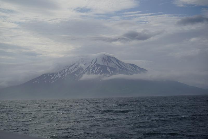
Ash Forecasting

Mathematical models developed by the USGS forecast various aspects of how a volcanic ash plume will interact with wind—where, how high, and how fast ash particles will be transported in the atmosphere, as well as where ash will fall out and accumulate on the ground. AVO runs these models when a volcano is restless by assuming a reasonable hypothetical eruption, to provide a pre-eruptive forecast of areas likely to be affected. During an ongoing eruption, AVO will update the forecast with actual observations (eruption start time and duration, plume height) as they become available.

View the current airborne ash cloud models for Gareloi

Ashfall thickness forecast

The Ash3d model was developed by the USGS to forecast how a volcanic ash plume will interact with wind and where ash will fall out and accumulate on the ground. AVO runs these models twice daily when a volcano is restless by assuming a reasonable hypothetical eruption altitude and duration. The map shows the model results of ashfall thickness for areas that are likely to be affected, if one were to occur. During an ongoing eruption, AVO will update the forecast with actual observations (eruption start time and duration, plume height) as they become available, and these plots will be automatically updated. The National Weather Service Anchorage Forecast Office will issue the official ashfall warning product and post them at weather.gov/afc

THESE PRODUCTS MAY NOT BE CURRENT.

During an actual eruption, see National Weather Service forecasts of ashfall:https://weather.gov/afc.

Ashfall Forecast

Click on the X on the graphic (upper right) to expand the map to show the map legend.

Ashfall Start Time

This map shows the modeled estimate of the time it would take for ashfall to begin following an eruption. It corresponds to the ashfall thickness forecast map shown above. This map uses the start time of either the twice-daily hypothetical model runs (time shown in the legend) or the actual eruption start time (if one were to occur). In the case of an actual eruption, the National Weather Service Anchorage Forecast Office will issue the official ashfall warning product that includes the ashfall start time and post them at weather.gov/afc

THESE PRODUCTS MAY NOT BE CURRENT.

During an actual eruption, see National Weather Service forecasts of ashfall:https://weather.gov/afc.

Ashfall Start Times Forecast

Click on the X on the graphic (upper right) to expand the map to show the map legend.
×