Veniaminof
Facts
- Official Name: Mount Veniaminof
- Seismically Monitored: Yes
- Color Code: GREEN
- Alert Level: NORMAL
- Elevation: 2507m (8225ft)
- Latitude: 56.1979
- Longitude: -159.3931
- Smithsonian VNum: 312070
- Pronunciation:
-
Nearby Towns:
- Ivanof Bay 20 mi (32 km) SW
- Perryville 22 mi (35 km) SE
- Chignik Lake 25 mi (40 km) NE
- Chignik Lagoon 34 mi (55 km) NE
- Chignik 39 mi (62 km) NE
Distance from Anchorage: 485 mi (781 km)
Description
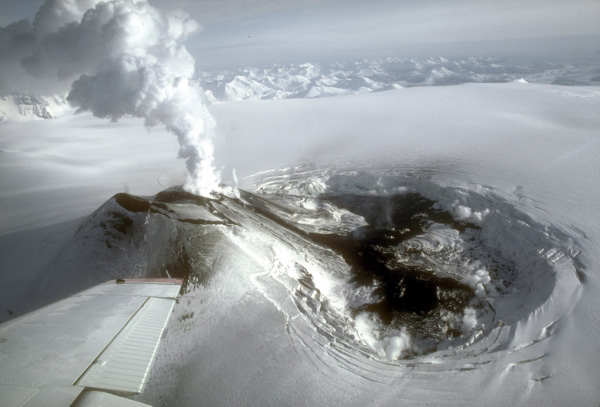
From Miller and others (1998) [1] : "Mount Veniaminof is a broad central mountain, 35 km wide at the base, truncated by a spectacular steep-walled summit caldera 8x11 km in diameter. The caldera is filled by an ice field that ranges in elevation from approximately 1750 to 2000 m; ice obscures the south rim of the caldera and covers 220 square km of the south flank of the volcano. Alpine glaciers descend from the caldera through gaps on the west and north sides of the rim and other alpine glaciers occupy valleys on the north-, east-, and west-facing slopes of the mountain. In the western part of the caldera, an active intracaldera cone with a small summit crater has an elevation of 2156 m, approximately 330 m above the surrounding ice field. The rim of a larger but more subdued intracaldera cone protrudes just above the ice surface in the northern part of the caldera; based on limited exposure and physiographic features, it may have a summit crater as much as 2.5 km in diameter."Andesitic and dacitic ash-flow tuffs from the caldera-forming eruption occur in many of the valleys on the north slope of the volcano and are found as far away as 50 km from the caldera rim on both the Bering Sea and Pacific Ocean coasts.
"A northwest-trending belt of post-caldera cinder and scoria cones, including the two intracaldera cones, extends from near the Bering Sea coast approximately 55 km across the main volcanic edifice and the Aleutian Range divide, well down the Pacific slope [2] ."
Name Origin
Constantin Grewingk in 1849 wrote "We have named this point on our maps 'Vukan Wenjaminow'." Named in honor on Father Ioann [Ivan Popov] Veniaminov, 1797-1879, Russian Orthodox priest, Bishop of Russian America, and Metropolitan of Moscow, whose writings on Unangam Tunuu language and ethnology are still standard references (Orth, 1971).
References Cited
[1] Catalog of the historically active volcanoes of Alaska, 1998
Miller, T. P., McGimsey, R. G., Richter, D. H., Riehle, J. R., Nye, C. J., Yount, M. E., and Dumoulin, J. A., 1998, Catalog of the historically active volcanoes of Alaska: U.S. Geological Survey Open-File Report 98-0582, 104 p.[2] Geologic map of the Chignik and Sutwik Island quadrangles, Alaska, 1981
Detterman, R. L., Miller, T. P., Yount, M. E., and Wilson, F. H., 1981, Geologic map of the Chignik and Sutwik Island quadrangles, Alaska: U.S. Geological Survey Miscellaneous Investigations Series Map I 1229, unpaged, 1 sheet, scale 1:250,000.Current Activity
Recent Updates


Webcams


Webicorder


RSAM


Color Code Timeline
Loading Past Activity...
Loading Images...
Loading Maps...
Loading Bibliography...
Before an eruption
Ashfall & Preparedness Information
- Ashfall impacts & preparedness (US Geological Survey)
- Volcanic health hazards & impacts (International Volcanic Health Hazards Network)
- Ash Alert! Pamphlet (AK Division of Homeland Security & Emergency Management)
- Volcanic Ashfall (AK Department of Environmental Conservation, Division of Air Quality)
During and After an Eruption
Ash Forecasting
Mathematical models developed by the USGS forecast various aspects of how a volcanic ash plume will interact with wind—where, how high, and how fast ash particles will be transported in the atmosphere, as well as where ash will fall out and accumulate on the ground. AVO runs these models when a volcano is restless by assuming a reasonable hypothetical eruption, to provide a pre-eruptive forecast of areas likely to be affected. During an ongoing eruption, AVO will update the forecast with actual observations (eruption start time and duration, plume height) as they become available.
View the current airborne ash cloud models for Veniaminof
Ashfall thickness forecast
The Ash3d model was developed by the USGS to forecast how a volcanic ash plume will interact with wind and where ash will fall out and accumulate on the ground. AVO runs these models twice daily when a volcano is restless by assuming a reasonable hypothetical eruption altitude and duration. The map shows the model results of ashfall thickness for areas that are likely to be affected, if one were to occur. During an ongoing eruption, AVO will update the forecast with actual observations (eruption start time and duration, plume height) as they become available, and these plots will be automatically updated. The National Weather Service Anchorage Forecast Office will issue the official ashfall warning product and post them at weather.gov/afc
THESE PRODUCTS MAY NOT BE CURRENT.During an actual eruption, see National Weather Service forecasts of ashfall:https://weather.gov/afc.
Ashfall Forecast
Ashfall Start Time
This map shows the modeled estimate of the time it would take for ashfall to begin following an eruption. It corresponds to the ashfall thickness forecast map shown above. This map uses the start time of either the twice-daily hypothetical model runs (time shown in the legend) or the actual eruption start time (if one were to occur). In the case of an actual eruption, the National Weather Service Anchorage Forecast Office will issue the official ashfall warning product that includes the ashfall start time and post them at weather.gov/afc
THESE PRODUCTS MAY NOT BE CURRENT.During an actual eruption, see National Weather Service forecasts of ashfall:https://weather.gov/afc.