Mount Spurr seismic activity Information Statement May 15, 2024
Summary of Current Activity
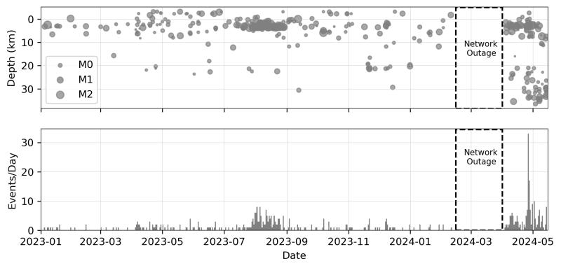
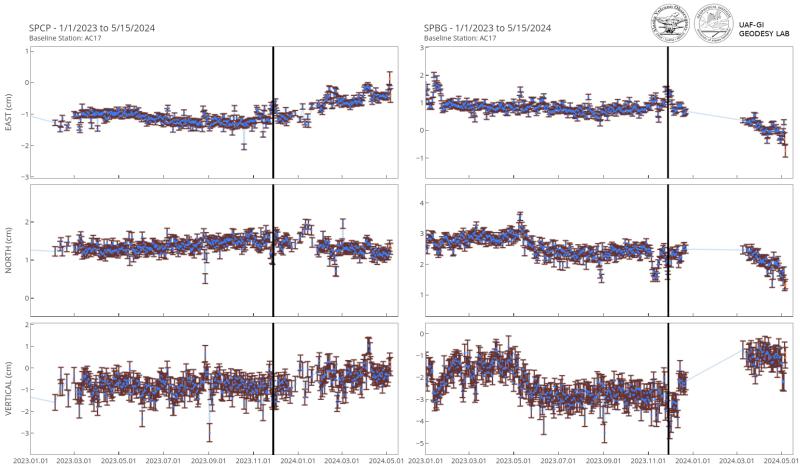
The Alaska Volcano Observatory (AVO) has detected a small increase in volcano seismic activity at Mount Spurr, which may indicate an intrusion of new magma deep beneath the volcano. An extended recent outage of the local seismic network from February to April 2024 limits precise determination of the onset of this activity, but elevated seismicity has been seen since the network returned on April 3. Since then, AVO has located an average of four earthquakes per day, with a peak of 33 recorded on April 26. These have typically been smaller than magnitude 1.0, and range in depth from near the summit of the volcano to as much as 18 miles (30 km) below sea level. This activity represents an increase in earthquake rate and occurrence of deeper (>12.4 miles or 20 km) low frequency earthquakes compared to recent years. These low frequency earthquakes are likely related to the migration of fluids. Minor uplift of the ground surface at the volcano of ~0.4 inches (~1 cm) has also been observed in local GPS data since November 2023, which is a deviation from the long-term trend and may be related to the seismicity. No significant changes to the ice and snow cover or gas and steam emissions have been observed in association with these geophysical observations. In clear viewing conditions, minor steaming is commonly visible from fumaroles in the summit crater region.
Monitoring Status
Mount Spurr is monitored by an eleven-station seismic network, four continuous GPS receivers, four infrasound sensors, and web cameras. Data from five of the eleven stations are currently coming into AVO in real time, but the other six stations in the network are only recording data locally. AVO plans to restore real-time feeds from those stations and recover the stored data during maintenance visits this summer, beginning on May 20, 2024. Additional regional seismic stations and infrasound sensors located throughout south-central Alaska provide supporting data. AVO also monitors the volcano using satellite monitoring, lightning data, pilot reports, and airborne and ground observations to detect changes in the snow and ice surfaces, thermal emissions, and volcanic ash, steam, and gas emissions. AVO conducted a short observational overflight on May 14, 2024, and another to measure gas emissions and make observations is planned for June.
Prognosis and Hazards
The activity that we have observed at Mount Spurr over the past six weeks is consistent with the intrusion of magma deep beneath the volcano. Such an intrusion can cause subtle inflation or swelling of the volcano and generate earthquakes through the release magmatic gasses.
While these observations suggest that increased activity may be occurring deep beneath Mount Spurr, there is no indication that an eruption may occur soon, if at all. Intrusions of new magma under volcanoes do not always result in volcanic eruptions and activity may decline without an eruption occurring, such as during the previous intrusion under Mount Spurr that occurred in 2004. Prior to a significant eruption, AVO would expect months of volcanic unrest that would allow advanced warning. This would likely consist of a greater increase and shallowing of earthquakes, increased uplift of the ground surface as magma rises to shallower levels in the Earth’s crust, and signs of increased heat and magmatic gas emissions, such as localized melting of summit glaciers and debris flows.
If Mount Spurr were to erupt, the primary hazard would be airborne ash and ashfall on down-wind communities. The slopes of the volcano would also be affected by pyroclastic flows, and lahars, or mudflows formed from the melting of ice and snow due to volcanic activity, could inundate drainages on all sides of the volcano, particularly on the south and east flanks.
Background
Mount Spurr volcano is an ice- and snow-covered stratovolcano located on the west side of Cook Inlet approximately 120 km (75 mi) west of Anchorage. The only known historical eruptions occurred in 1953 and 1992 from the Crater Peak flank vent located 3.5 km (2 mi) south of the summit of Mount Spurr. These eruptions were brief, explosive, and produced columns of ash that rose up to 20 km (65,000 ft) above sea level and deposited several mm of ash in south-central Alaska, including approximately 6 mm of ash on Anchorage in 1953. The last known eruption from the summit of Mount Spurr was more than 5,000 years ago. An intrusion of magma in 2004 generated earthquakes, ground deformation, and heat and gas emissions. The associated geothermal activity melted snow and ice at the summit of Mount Spurr. As this occurred, meltwater associated with the elevated heat flow traveled through the crevassed ice cover and produced several debris flows that were evident around the summit. Primary hazards during future eruptions include far-traveled ash clouds, ash fall, pyroclastic flows, and lahars or mudflows that could inundate drainages all sides of the volcano, but primarily on the south and east flanks.