Mount Spurr activity Information Statement July 3, 2024
Summary of Current Activity
New observations of a small lake in the summit crater of Mount Spurr support recent seismic and deformation data that indicate a possible minor intrusion of magma has occurred beneath the volcano over the last several months. While the formation of the lake is new, gas emissions remain low and seismic activity is declining, suggesting the probability of an eruption in the near future has not significantly increased. No surface changes have been observed at Crater Peak, the vent 2 miles (3 km) south of the summit associated with all historical eruptions.
The lake first appeared between May 15 and June 15, and was well documented during a June 23 overflight (see photo below) when it had an area of about 1 acre (3800 square meters). The last time a crater lake formed at the summit of Mount Spurr was during seismic unrest in 2004 that did not lead to an eruption.
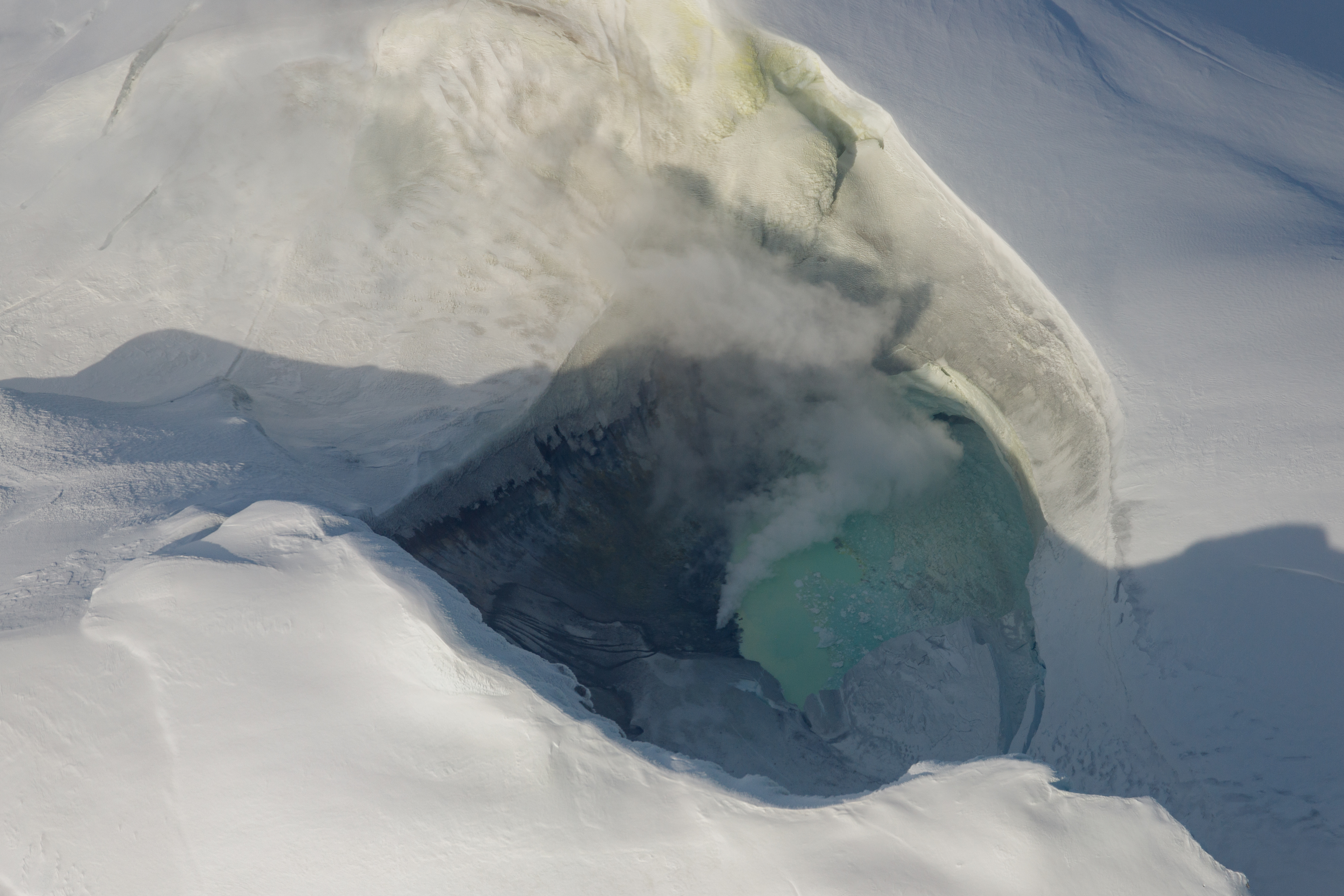
The June 23 overflight also monitored gas emissions from the volcano and detected low levels of sulfur dioxide and carbon dioxide. The measured compositions are similar to background levels measured in previous years. Deep intrusion of magma is sometimes associated with anomalously high volcanic carbon dioxide emissions, but no such anomaly was detected during the overflight.
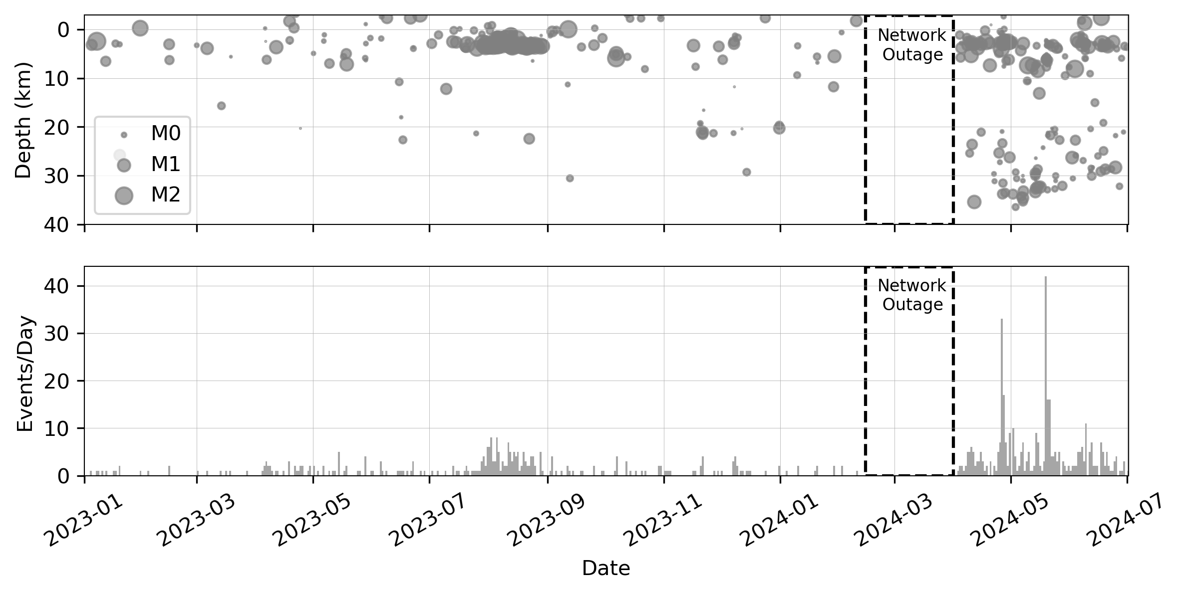
Seismic activity beneath Mount Spurr has been above normal levels since spring 2024, but starting on May 20, the degree of seismic unrest has declined and remains slightly elevated (see figure below). The occurrence of deeper (>12.4 miles or 20 km) low frequency earthquakes has been above background levels since spring 2024. A small amount of deformation, consistent with a shallow (less than 3 miles or 5 km depth) source of inflation, has been observed in GNSS data. Similar to the earthquake activity, the rate of deformation appears to be decreasing.
Monitoring Status
Mount Spurr is monitored by a local seismic network, GPS and infrasound sensors, and a webcam. Remote sensing data including satellite imagery, regional infrasound sensors, and lightning data are also used to detect potential eruptions at the volcano.
Background
Mount Spurr volcano is an ice- and snow-covered stratovolcano located on the west side of Cook Inlet approximately 75 miles (120 km) west of Anchorage. The only known historical eruptions occurred in 1953 and 1992 from the Crater Peak flank vent located 2 miles (3.5 km) south of the summit of Mount Spurr. These eruptions were brief, explosive, and produced columns of ash that rose up to 65,000 feet (20 km)above sea level and deposited minor ashfall in south-central Alaska (up to ¼ inch or 6 mm). The last known eruption from the summit of Mount Spurr was more than 5,000 years ago. In 2004, Mount Spurr experienced an episode of increased seismicity, surface uplift, and heating that melted a large hole in the summit ice cap and generated debris flows. Primary hazards during future eruptions include far-traveled ash clouds, ash fall, pyroclastic flows, and lahars or mudflows that could inundate drainages all sides of the volcano, but primarily on the south and east flanks.