Kupreanof Information Statement June 22 2026
KUPREANOF (VNUM #312060)56°45" N 159°47'28" W, Summit Elevation 6217 ft (1895 m)Current Volcano Alert Level: ADVISORY
Current Aviation Color Code: YELLOW
Summary: Seismic activity and gas emissions continue at Mount Kupreanof alongside newly detected ground deformation, consistent with the ongoing intrusion of magma beneath the volcano.
Overview
- Seismic activity and sulfur dioxide (SO2) emissions from Mount Kupreanof have remained elevated since the Aviation Color Code and Volcano Alert Level change to YELLOW/ADVISORY on May 12.
- New satellite deformation measurements have detected uplift of the ground surface in the area around the volcano occurring sometime since October 2025.
- The seismicity, gas, and deformation signals are due to a magmatic intrusion beneath the volcano.
- The volcano remains at YELLOW/ADVISORY, and there are no indications from available data that an eruption is imminent.
Recent Observations
Earthquakes
Seismic unrest that began in February 2026 beneath Mount Kupreanof (https://avo.alaska.edu/volcano/kupreanof) continues. Since the Aviation Color Code and Volcano Alert Level change to YELLOW/ADVISORY on May 12, shallow seismicity has remained elevated with more than 30 earthquakes of magnitude 1 or greater. The largest events to date occurred on June 15 and 16 and had magnitudes of 3.2 and 3.6, respectively.
The Alaska Volcano Observatory (AVO) does not maintain a local monitoring network at Mount Kupreanof, and seismicity is therefore detected using regional stations. The closest functioning seismometer is currently located 17 miles (27 km) to the east at Mount Veniaminof. The lack of a local monitoring network and the limited number of regional stations mean that smaller events (magnitudes less than 2) are often not detected or located, and earthquake locations have relatively large uncertainties. The largest earthquakes at Mount Kupreanof may also be analyzed and reported by the Alaska Earthquake Center and the U.S. Geological Survey National Earthquake Information Center. Earthquake magnitudes and locations from these agencies may differ slightly from AVO due to differences in techniques. Mount Kupreanof is also monitored by satellite data, remote infrasound and lightning networks, and visual observations from pilots and mariners passing by the volcano.
Gas Emissions
Since May 12, sulfur dioxide emissions have been seen in satellite data on 13 days with calculated emission rates between 100 to 800 tons per day, similar to the rate of emissions seen since April. These elevated emission rates are consistent with degassing of new, relatively shallow magma beneath the volcano.
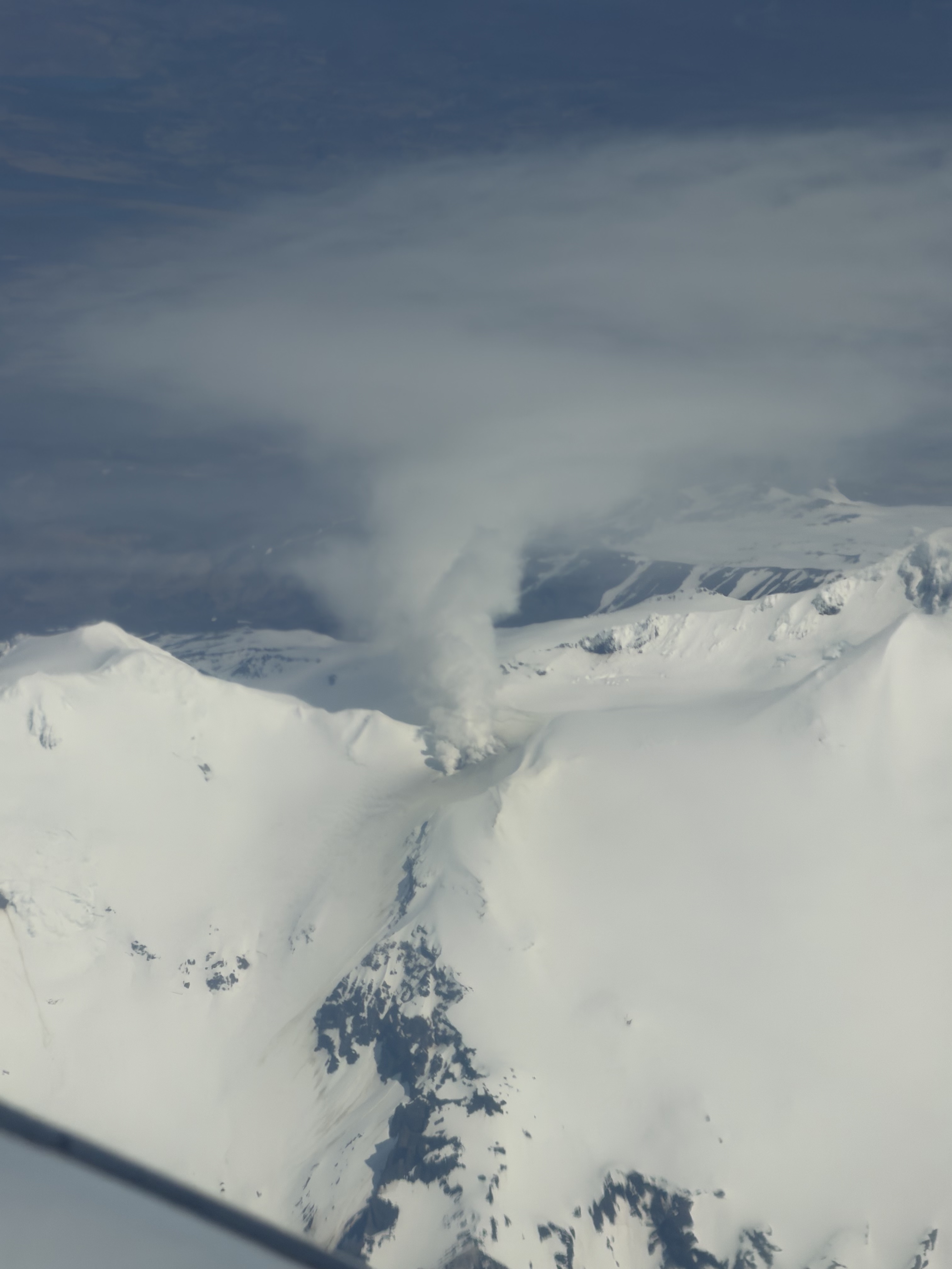
Vigorous steaming is visible from the persistently active fumarole field to the west of the summit of Mount Kupreanof in this oblique aerial photo taken on June 5, 2026. Although steaming in this location is typical, the degassing plume now contains more sulfur dioxide, indicating that magma has intruded to relatively shallow levels beneath the volcano. Image courtesy of Carson Klemp.
Deformation
Satellite interferometric radar (InSAR) ground deformation data collected in mid-June, following sufficient snow melt, compared with data from before snow cover (September 30, 2025) indicate uplift of the ground around the volcano occurred sometime in the past 8 months (https://avo.alaska.edu/image/view/197259). The source depth of this inflation signal is likely around 3.7 miles (6 km) below sea level. These results are consistent with a magmatic intrusion, in agreement with the seismic and gas data.
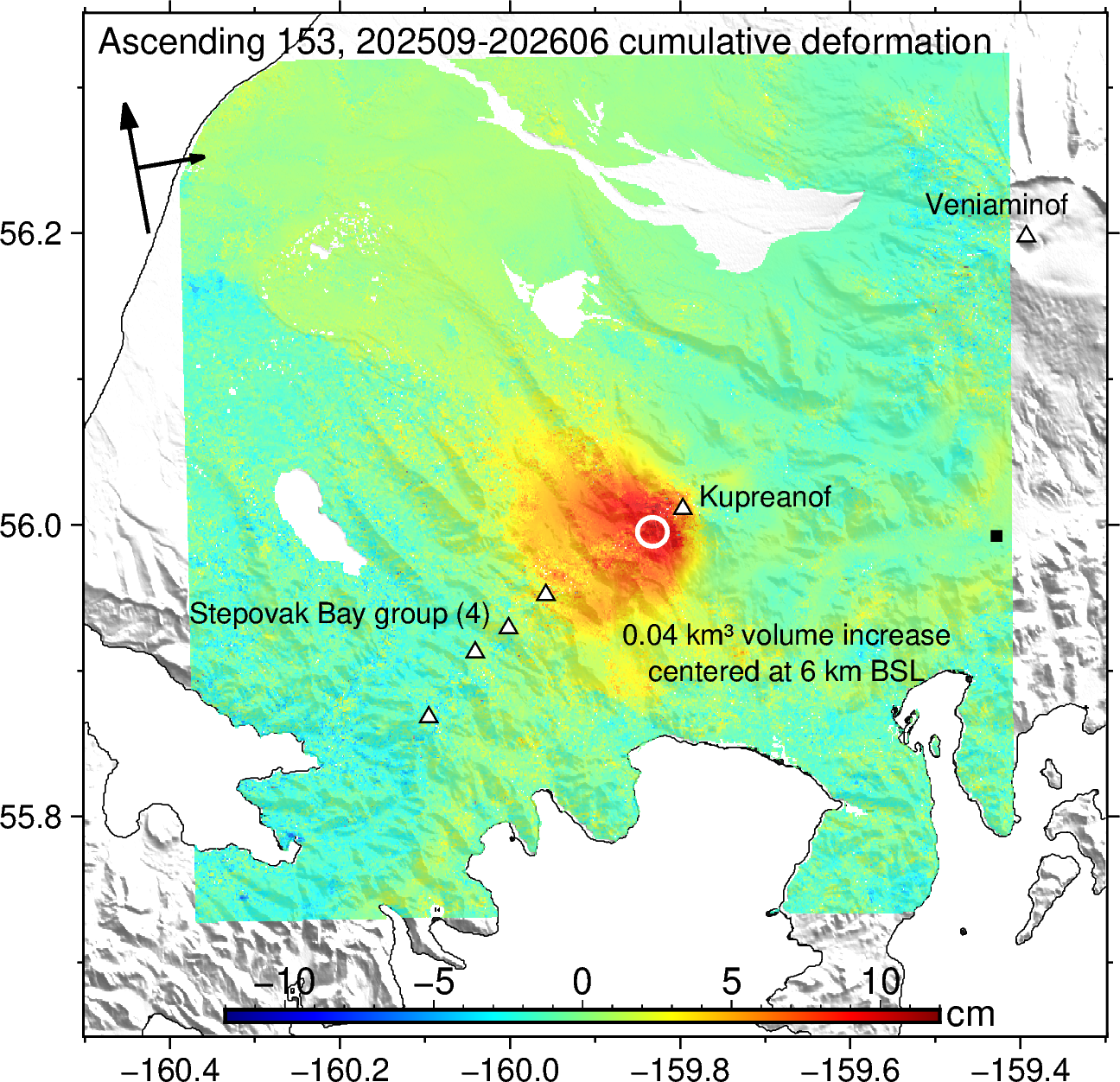
nwrapped Sentinel-1 interferogram along ascending path 153 showing up to 10 cm of cumulative inflation at Kurpeanof Volcano along the satellite line of sight between Sept. 30, 2025 and June 10, 2026. These observations are currently best explained by an inflating spherical magma source at ~6 km below sea level (BSL) that increases in volume by ~0.04 km3. The location of this source is marked by the white circle. The triangles show other volcanoes in the region. The black square indicates the reference location (assumed stable) relative to which deformation is shown. The arrows in the top left show satellite flight direction and look direction. Image courtesy of the AVO/UAF-GI.
Interpretations and Hazards
The earthquake types and locations, observed sulfur dioxide emissions, and new deformation signal indicate that magma has intruded to relatively shallow depths beneath Mount Kupreanof. No major changes associated with this intrusion have been observed at the steam vents in a fumarole field at about 5,000 ft elevation west of the summit. Because of the active steam venting, if eruptive activity does occur, it may be either hydrothermal (steam driven) or magmatic. Intrusions of new magma under volcanoes do not always result in volcanic eruptions. The earthquake activity, deformation, and gas emissions at Mount Kupreanof may cease with no eruption occurring. If the magma rises closer to the surface, it will likely lead to increased unrest, such as a change in the rate and style of earthquake activity, surface heating, and increased gas emissions. Therefore, it is very likely that if an eruption were to occur it would be preceded by additional signals that would allow advance warning.
If an eruption were to occur, the primary hazards would be from pyroclastic flows, lahars (volcanic debris flows), volcanic ashfall, and airborne volcanic ash. Due to its remote location, pyroclastic flows would only affect uninhabited areas but would likely generate lahars that could inundate rivers to the north and south of the volcano. The areas that could be impacted by ashfall and airborne ash are dependent on the amount of ash produced, the altitude of the ash, and the direction and speed of the wind at the time of the eruption. This could result in ashfall in nearshore waters and potentially on populations in the region. Drifting clouds of airborne ash could disrupt regional and international air traffic.
Background
Mount Kupreanof is a heavily glaciated stratovolcano on the Alaska Peninsula with no known historical eruptions. Very little is known about its eruptive history. A single debris flow or block-and-ash flow deposit has been mapped in a valley south of the volcano with a suspected Holocene age. Eruptions will likely produce lahars and pyroclastic flows on the volcano's flanks and into the surrounding uninhabited valleys. Ash plumes could affect communities and airplanes downwind of the volcano. A vigorous fumarole field just west of the summit produces persistent steam plumes.
CONTACT INFORMATION:
Matt Haney, Scientist-in-Charge, USGS, mhaney@usgs.gov (907) 786-7497
Ronni Grapenthin, Acting Coordinating Scientist, UAFGI, rgrapenthin@alaska.edu (907) 378-5460
Contact AVO: https://avo.alaska.edu/contact
The Alaska Volcano Observatory is a cooperative program of the U.S. Geological Survey, the University of Alaska Fairbanks Geophysical Institute, and the Alaska Division of Geological and Geophysical Surveys.
×
![Instrument data]()