Edgecumbe ongoing low-level activity information statement February 9, 2024
This Information Statement provides an update on the ongoing, low-level volcanic unrest at the Mount Edgecumbe volcanic field.Summary
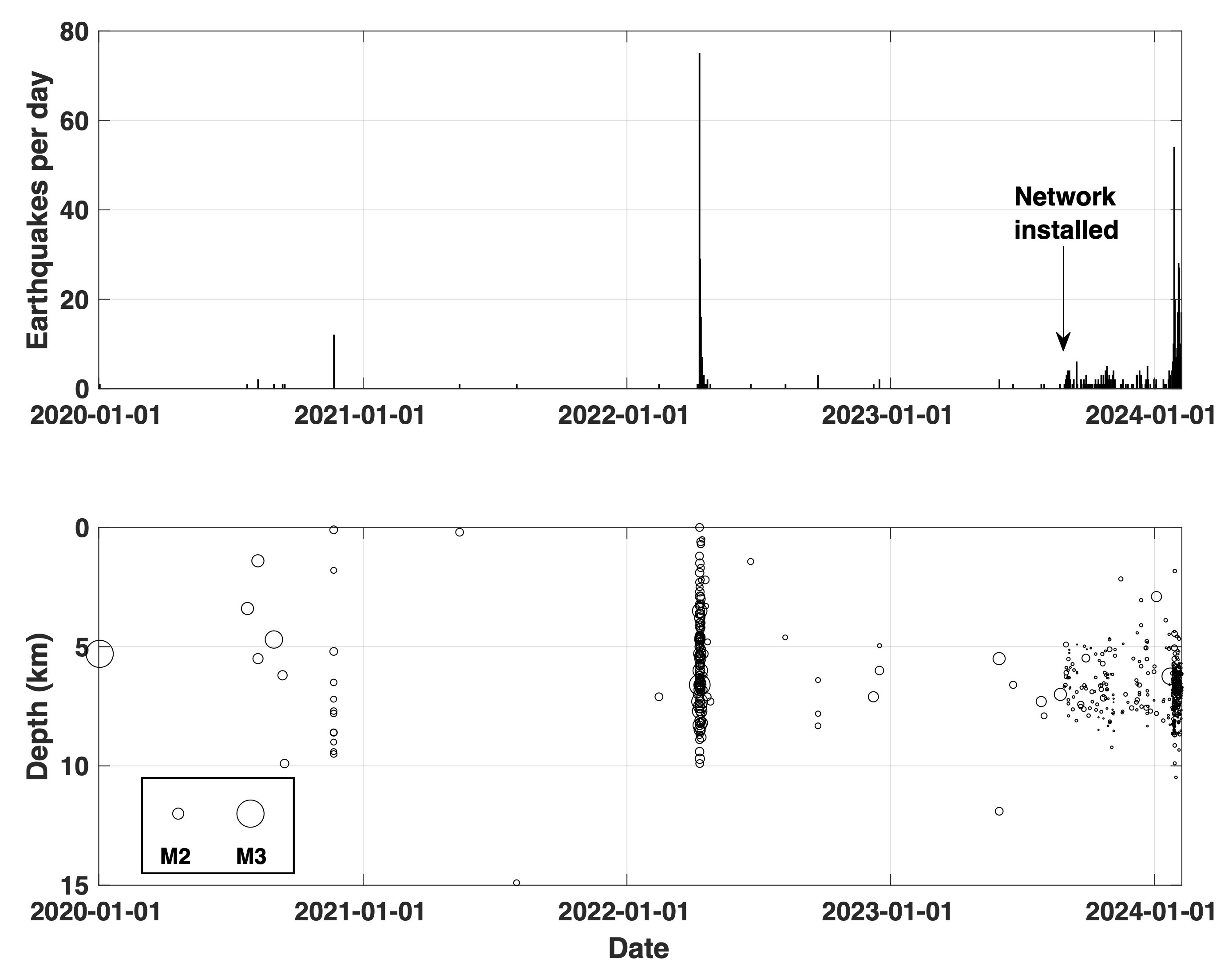
• Since the installation of a 4-station monitoring network in August 2023, AVO has detected about 1 small earthquake per day under the Mount Edgecumbe volcanic field.
• There was an increase in the rate of small earthquakes in late January 2024. The rate has varied, but there have been about ten earthquakes located per day since then.
• The new network allows AVO to detect more and smaller earthquakes than was possible before. Only a few of the earthquakes over the past few months would have been detected before the installation of the new network, suggesting that the current activity is not out of the ordinary for the volcano.
• Surface uplift rates have declined, and no unusual gases or other signs of surface unrest have been observed.
Current Observations
Since installing a 4-station monitoring network in August 2023 (through January 26, 2024), AVO has detected about one small earthquake per day under the Mount Edgecumbe volcanic field on southern Kruzof Island. Most quakes are 4 to 9 kilometers (2.5 to 5.5 miles) below sea level.
The number of earthquakes increased on January 27, 2024, with 84 located quakes over two days. Since January 29, the rate has remained elevated, with an additional 125 located quakes through February 7. These earthquakes have mostly been small, with most (91%) less than magnitude one and the rest lower than magnitude 2. The depths of these more recent earthquakes remain the same as those detected previously.
AVO’s ability to detect and locate earthquakes at the Mount Edgecumbe volcanic field has increased as new seismic instruments have been installed. The current network allows AVO to detect more minor earthquakes than before. Before August 2023, AVO could mainly detect earthquakes larger than about magnitude 1. Only a few earthquakes over the past several months would have been detected before AVO installed the new network. The current activity is probably not unusual for this volcanic field.
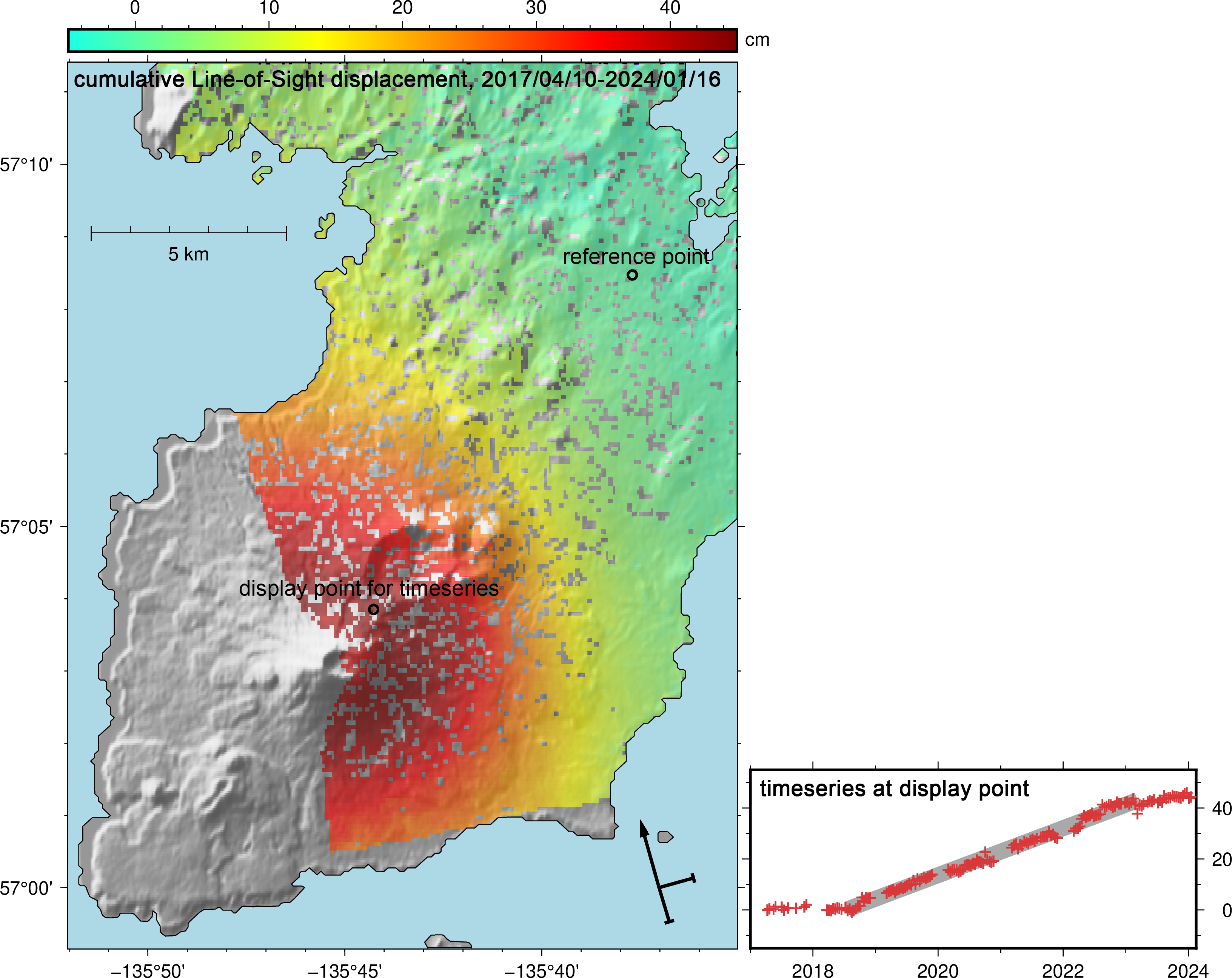
Ongoing analysis of satellite radar data and data from GNSS (GPS) sites on Kruzof Island shows that deformation of the ground surface at Edgecumbe continues but at a lower rate than was observed in previous years. The rate of ground uplift, as of early February, is about 2-3 centimeters/year (0.8-1.2 inches/year).
Some Sitka residents observed bubbling water near the eastern shoreline of Kruzof Island near Mount Edgecumbe in fall 2022. AVO scientists visited this area in summer 2023 and collected gas samples. Chemical analyses of these samples did not detect any volcanic gases.
Details of unrest, 2018 to present
A swarm of earthquakes was detected in the vicinity of Mount Edgecumbe volcano beginning on April 11, 2022. There were hundreds of small quakes in the swarm, though the large majority were too small to locate.
That swarm inspired an in-depth analysis of ground deformation detectable with radar satellite data going back several years. Analysis of these data revealed a broad area, about 17 km (10.5 miles) in diameter, of surface uplift centered about the summit region of Mt Edgecumbe. This uplift began in August 2018 and has been continuing to the present, though the rate has decreased from 7.4 centimeters/year (2.9 inches/year) to 2-3 centimeters/year (0.8-1.2 inches/year) in the center of the deforming area. The total surface uplift since 2018 is about 42 centimeters (16.5 inches).
Retrospective analysis of earthquake data in the area of Mount Edgecumbe showed that a small number of earthquakes started occurring under the volcano in 2020. The increased earthquake activity that started on April 11, 2022, was unusual in having a greater number of events, however. The earthquakes detected under the volcano since 2020 are all magnitude 3.0 or smaller.
Prognosis
The coincidence of earthquakes and ground motion in time and location over the past few years suggests that these signals are due to the movement of magma beneath Mount Edgecumbe, rather than tectonic activity. The ground uplift, or deformation, is consistent with movement of magma to about 10 km (6.2 miles) below sea level. The earthquakes are likely caused by stresses in the crust due to this intrusion and the substantial uplift that it is causing.
Intrusions of new magma under volcanoes do not always result in volcanic eruptions. The deformation and earthquake activity at Edgecumbe may cease with no eruption occurring. If the magma rises closer to the surface, this would lead to changes in the deformation pattern and an increase in earthquake activity. Therefore, it is very likely that if an eruption were to occur it would be preceded by additional signals that would allow advance warning.
Current monitoring
The Alaska Volcano Observatory installed a permanent monitoring network on Kruzof Island in August 2024 that consists of four seismic and GNSS (GPS) stations. This has improved our ability to accurately locate earthquakes, detect other seismic signals related to the volcano, and track ground motion. Updated satellite radar observations become available on weekly timescales.
AVO plans a site visit to perform maintenance on the network in May 2024.
For current information about Edgecumbe, including our latest information releases and monitoring data, see Alaska Volcano Observatory | Edgecumbe.
×
![Instrument data]()