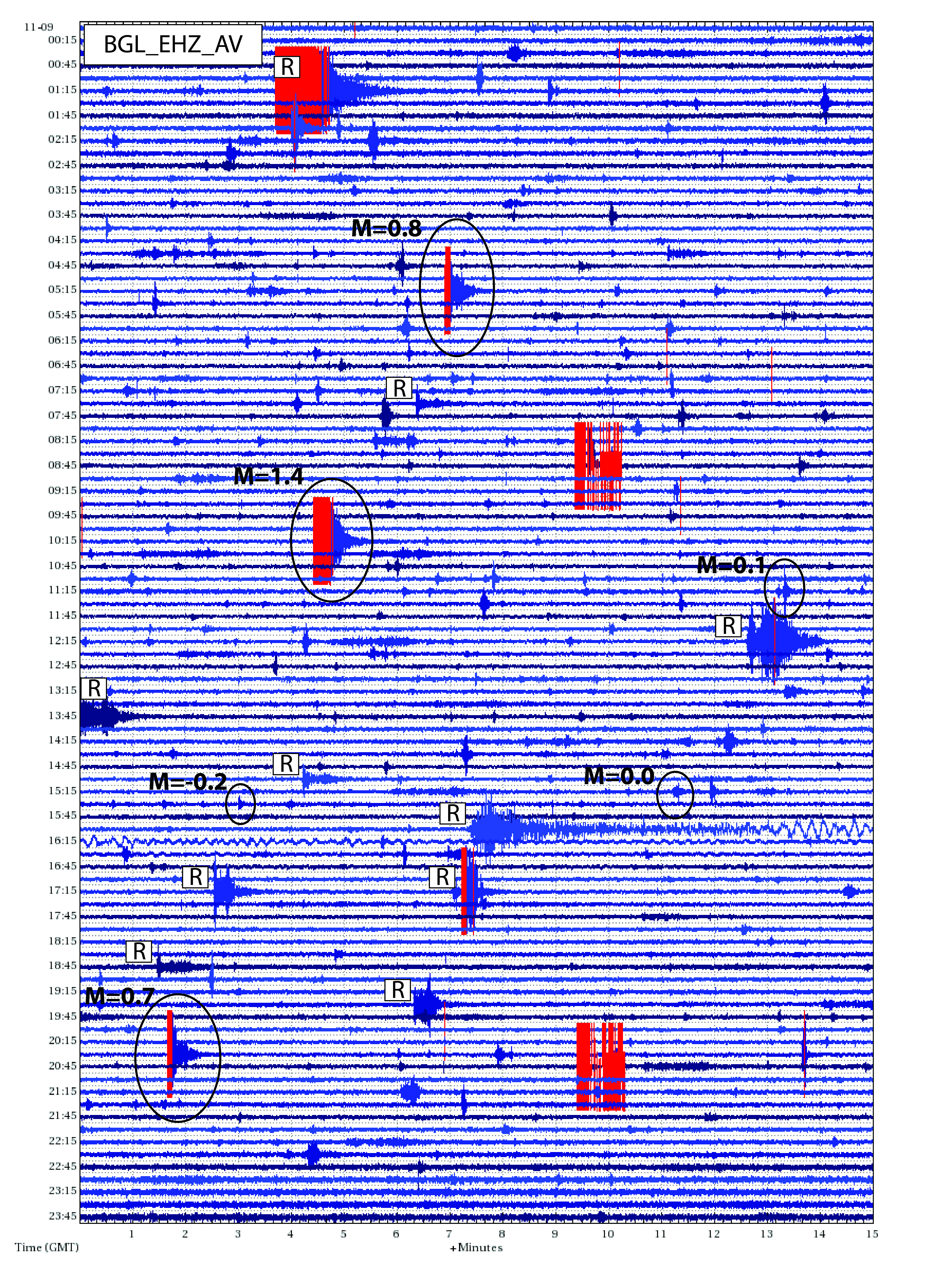
Annotated 24-hour webicorder display for station BGL at Mount Spurr Volcano on November 9, 2015 UTC. Six earthquakes, circled on the figure, occurred on November 9th, including the largest earthquake (M=1.4) in the sequence. The only UTC day with more located earthquakes in the swarm is November 11 with seven. Regional earthquakes that have occurred throughout Alaska are indicated by an “R. There was one earthquake at Spurr (02:05 UTC) that was not located in the swarm. The webicorder display was created with swarm with data available from IRIS. Swarm is a program for the real-time analysis of seismic waveform data. Currently it can load data from Earthworm Wave Servers, Winston Wave Servers, SEED volumes, and SAC files. Seismic data is available from IRIS at http://ds.iris.edu/mda/AV Figure by Jim Dixon, USGS/AVO.
Volcano(es): Spurr
Photographer: Dixon, Jim
URL: avo.alaska.edu/image/view/96871
Credit: Figure courtesy of AVO/USGS.
Use Restriction: Please cite the author and the Alaska Volcano Observatory / U.S. Geological Survey when using this image.
Full Resolution.
Spurr 2015/7
From Dixon and others, 2017: "No volcanic activity was reported at Mount Spurr in 2015; the only activity noted was an earthquake swarm 12 km (6.5 mi) north of the summit. First noted in the AVO internal logs in mid-October, earthquakes in this area occurred sporadically for the previous 5 months with the rate increasing from 1-2 per week in July to several per day in October. The swarm peaked in November, with 47 earthquakes during the month. The rate of located earthquakes decreased by one-half in December and the swarm continued into 2016 at a much-reduced level of activity. The earthquakes in this cluster were shallow with 90 percent occurring between 3 and 5 km (1.6 to 2.7 mi) below sea level. The Aviation Color Code and Volcano Alert Level remained at GREEN/NORMAL through the year at Spurr."
In 2016, there were four distinct clusters of seismicity at Spurr: "the typical Mount Spurr summit earthquakes that occurred throughout the year, earthquakes near Pothole Glacier (west of Mount Spurr) in late summer, an ongoing swarm of low-frequency earthquakes 10–15 km (6–9 mi) north of the summit (north Spurr earthquakes in fig. 5), and a cluster of earthquakes located 5 km (about 3 mi) east of the summit in May (east Spurr earthquakes in fig. 5). In addition to these areas of high activity, there are three, less-distinct zones of activity. These zones are 10 km (6.2 mi) south, 5 km (3 mi) west, and 20–30 km (12–18.5 mi) northeast of Mount Spurr and are in the area of the 1996 Strandline earthquake (Kilgore and others, 2011). The Aviation Color Code and Volcano Alert Level remained at GREEN and NORMAL, respectively, throughout the year for Spurr." (Cameron and others, 2020).
Dixon and others (2020) report the seismicity at Spurr continued into 2017, including the unusual earthquake sequence that began in 2015. "This cluster of low-frequency earthquakes (north Spurr earthquakes), was located 12 kilometers (km; 7 mi) north of Mount Spurr and continued to show activity throughout 2017. Although the character of the earthquakes is similar to glacial earthquakes, AVO has not determined a definite cause for this cluster of seismicity. The other four clusters (Mount Spurr summit, south Spurr, west Spurr, and the Strandline Lake earthquakes) are typical seismicity seen year-round in the vicinity of Mount Spurr (fig 2). An April 20 gas observation flight noted that the small plume emanating from the fumaroles in Spurr’s summit crater contained detectable quantities of SO2, H2S, and HCl. The Aviation Color Code and Volcano Alert Level remained at GREEN and NORMAL throughout the year at Mount Spurr."