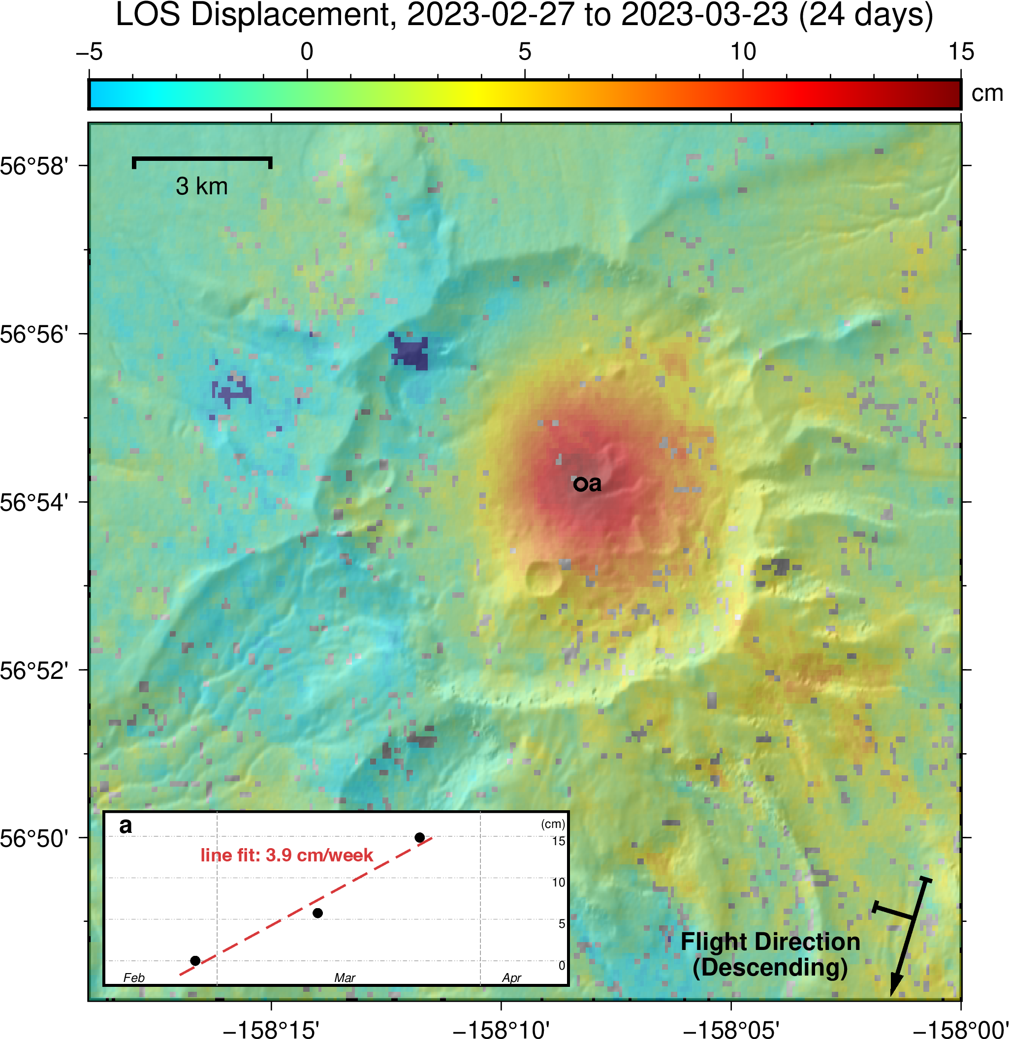
InSAR-derived ground surface change at Aniakchak volcano based on Sentinel-1 SAR acquisitions between February 27 and March 23, 2023. Colors in the main map show cumulative displacement in the satellite line-of-sight (LOS) direction (uplift of the ground surface toward the satellite) up to 6 inches (15 cm) over the 24-day observation period within the caldera. Point labeled "a" on the map marks the location for which the time series inset shows the evolution of the displacement over three satellite acquisitions. The deformation was also detectable earlier, between February 3 and 27, 2023, but cannot be resolved in this figure due to poor data quality from snow cover. Fitting a line results in a rate of displacement of ~4 cm (1.6 in) per week over this time span.
Volcano(es):
Photographer: Cheng, Yitian
URL: avo.alaska.edu/image/view/194292
Credit: Image courtesy of the AVO/UAF-GI.
Use Restriction: Please cite the photographer and the Alaska Volcano Observatory / University of Alaska Fairbanks, Geophysical Institute when using this image.
Full Resolution.
Aniakchak unrest 2023
On February 22, 2023, AVO raised the Aviation Color Code and Volcano Alert Level at Aniakchak to YELLOW/ADVISORY, citing increased seismicity. "The number of earthquakes beneath Aniakchak volcano has recently increased and shifted to shallower depths. Due to this increase in seismic activity to above-background levels, the Alaska Volcano Observatory is raising the Aviation Color Code to YELLOW and the Volcano Alert Level to ADVISORY. There have been no signs of unrest in other monitoring data.
Background seismicity at Aniakchak has mostly been characterized by deep (>15 km or 9.3 miles), long-period events occurring at a rate of ~4 earthquakes per month. From October 2022 to present, the rate of earthquakes has been more elevated and characterized by shallower earthquakes at depths less than 9 km (5.6 miles) below sea level. The earthquake rate has further increased since January 31 with dozens of earthquakes detected per day, including a M3.7 earthquake on February 17.
There is no indication that an eruption of Aniakchak is imminent, or that one will occur. Increases in seismic activity have been detected previously at other similar volcanoes, with no subsequent eruptions. We expect additional shallow seismicity and other signs of unrest, such as gas emissions, elevated surface temperatures, and surface deformation to precede any future eruption, if one were to occur. Should activity increase, AVO will issue further notices."
Seismic activity continued at similar rates for a few weeks, then began to slowly decline while remaining above background. However, radar data in March showed that the ground within the central caldera was rising. On April 13, an Information Statement was issued, stating that the earthquake activity and ground uplist suggested that magma was intruding below Aniakchak at 2 to 2.5 mi depth.
Uplift continued into June, though at a slower rate. Earthquake activity declined still further around mid-June, though station outages limited data. The outages were fixed in early July.
In late July, there was a small uptick in seismic activity. However, levels declined again the next week.
In late July to early August, radar data showed no continued uplift of the area.
On August 17, 2023, AVO lowered the color code and alert level to GREEN/NORMAL, stating that earthquake and deformation activity had returned to background levels.