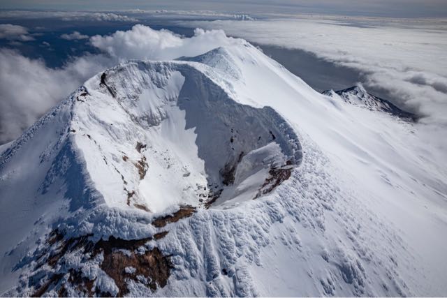
Aerial photo of the summit of Gareloi volcano, looking south. Kavalga Island is in the upper left for reference. The enclosed crater sits atop the volcano's north peak, which is its true summit. Note the relatively snow-free area on the north side of the cone. Beyond the north peak crater, the north rim of the south peak crater is visible, with a white steam plume coming from the persistent fumarole on the west rim of the south peak crater.
Volcano(es): Gareloi
Photographer: Ketner, Dane
URL: avo.alaska.edu/image/view/170161
Credit: Image courtesy of AVO/USGS.
Use Restriction: Please cite the photographer and the Alaska Volcano Observatory / U.S. Geological Survey when using this image.
Full Resolution.
Gareloi 2021 unrest
From Orr and others, 2024: "Beginning on May 18, 2021, anomalous seismicity was recorded at the Mount Gareloi. In particular, the low-energy LP events commonly observed at the volcano overlapped with a harmonic tremor recorded on every station on the island. The dominant tremor frequencies peaked at ~3.4 hertz (Hz), ~6.4 Hz, ~8.3 Hz, and ~10.7 Hz. These harmonic signals, which were intermittent during at least the previous day, became conspicuous after a regional ML 5.0 earthquake at 20:42 HADT on May 17 (05:42 UTC on May 18), though this change might be coincidental. Harmonic tremor took place intermittently until May 27, when highly frequent and highly energetic LP events emerged, sometimes merging into continuous broadband tremor. An ~2-Hz infrasound signal was also recorded locally on June 3, although it was unclear if the signal was of volcanic origin. A monochromatic, ~7 Hz seismic signal lasting 15-20 min was recorded on June 6, while elevated-amplitude seismicity, ongoing since about May 27, continued. Hence, on June 8, AVO raised the Aviation Color Code and Volcano Alert Level to YELLOW and ADVISORY. The increase in seismic activity likely reflected a change to the magmatic-hydrothermal system interaction. No indications of unrest, however, were observed by an AVO field crew that flew over the summit on May 23.
"Over the following two months, the elevated and anomalous seismicity continued intermittently; SO2 was detected in satellite imagery but was consistent with measurements from the last several years; light steaming was observed in partly cloudy satellite and webcam views of the volcano; and weakly elevated surface temperatures were sometimes observed in satellite data. No eruptive activity was observed in satellite views of the volcano and no activity was detected by local or regional infrasound sensors. Starting in the second week of July, seismic activity gradually diminished and returned to background levels. AVO lowered the Aviation Color Code and Volcano Alert Level to GREEN and NORMAL on July 28, 2021."