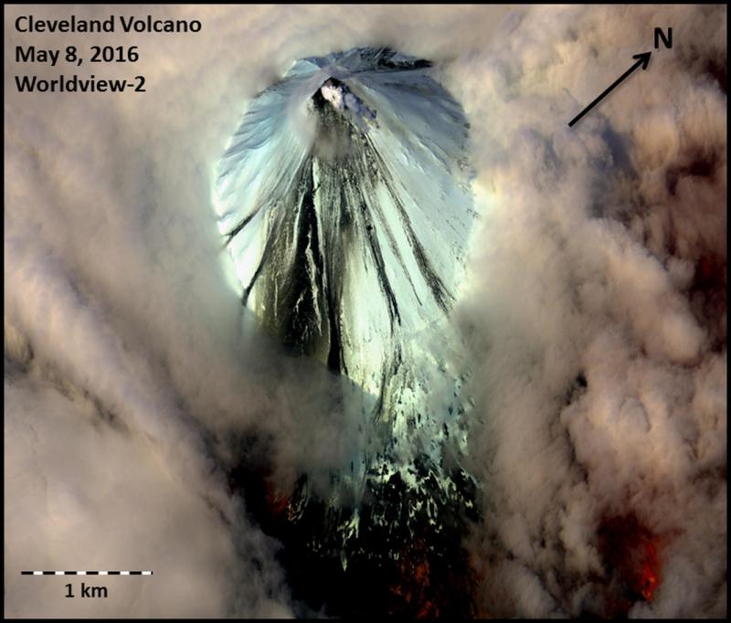
False-color satellite image of Cleveland Volcano collected by the Worldview-2 satellite on May 8, 2016. Ash deposits and debris flows generated by an explosion on May 5, 2016 are visible on the southeast portion of the cone.
Volcano(es): Cleveland
Photographer: Schneider, David
URL: avo.alaska.edu/image/view/95411
Credit: Image courtesy of AVO/USGS.
AVO does not hold copyright to this image and displays it with the permission of the copyright holder. This image is NOT in the public domain. Please see the use restrictions below.
Use Restriction: Please cite the photographer and the Alaska Volcano Observatory / U.S. Geological Survey when using this image.
Full Resolution.
Cleveland 2016/4
From Cameron and others (2020): "Mount Cleveland began 2016 at Aviation Color Code YELLOW and Volcano Alert Level ADVISORY after its August 7, 2015, explosion. A small lava dome emplaced after this explosion was still present at the beginning of 2016, and no changes to the dome were noted in the first few months of 2016 from satellite imagery. Minor steaming and weakly elevated surface temperatures were noted intermittently. The first explosion of 2016 occurred April 16 at 18:58 UTC (10:58 AKDT). In response, AVO raised the Aviation Color Code and Volcanic Alert Level to ORANGE and WATCH, respectively. This explosion was first detected by local infrasound sensors at seismograph stations CLES and CLCO, 3.5km (2.1 mi) and 15 km (9 mi) from the summit, respectively, and was the 40th explosion recorded at Mount Cleveland by AVO since December 25, 2011. Similar to most explosions at Mount Cleveland, the explosion had an impulsive onset and short duration (fig. 32). However, this explosion slightly differed from previous explosions by having a larger amplitude that exceeded the measurement scale of the local infrasound sensor CLES and was over 200 pascals at the CLCO infrasound sensor, 15 km (9 mi) away. The infrasound signal lasted more than 10 minutes at CLES, suggesting additional ash venting after the initial eruption. Retrospective analysis of geophysical data shows possible discrete precursory infrasound and seismicity beginning about 4 hours before the explosion (figs. 32, 33). Finally, there was a very long-period seismic signal at the time of the explosion. This is the first precursory and coeruptive seismicity noted by AVO at Mount Cleveland and the only instance in 2016.
"Vigorous steaming continued at the summit for about a week after the April 16 explosion. On April 18, satellite imagery showed that the upper northeast flanks of Mount Cleveland were covered with new tephra and ballistic blocks from the April 16 explosion. Subsequent satellite imagery also showed the lava dome was completely removed, and a 35-m-diameter vent, surrounded by a smaller tephra cone was visible. Because of no further eruptive activity, AVO lowered the Aviation Color Code and Volcanic Alert Level to YELLOW and ADVISORY, respectively, on April 29.
"A new, 30-m-diameter lava dome appeared in satellite imagery on May 5. Soon after this satellite observation, the second explosion of 2016 occurred on 2:43 UTC May 6 (18:43 AKDT May 5). The explosion was detected both by local and remote infrasound sensors, local seismic stations, and ground-coupled airwaves on the seismic networks of nearby volcanoes. This explosion was about half the seismic amplitude of the April 16 event. Unlike the previous explosion, no obvious precursory seismicity was observed. AVO upgraded the Aviation Color Code and Volcano Alert Level to ORANGE and WATCH respectively the same day in response to this eruption. A few days later, on May 10, another small explosion (three times smaller in infrasound amplitude than the previous explosion) occurred at 15:32 UTC (07:32 AKDT). The infrasound signal showed multiple compressions, likely attributed to slow destruction of the dome. Satellite imagery on May 11 confirmed that the early May dome was completely removed, leaving behind a shallow vent. New flowage deposits extending in several directions from the summit crater were also noted. A Landsat-8 image from May 15 shows robust steaming and high temperatures in the summit crater (fig. 34).
"Satellite views on May 18 showed a new, low-relief 50-m-(164-ft-) diameter lava dome centered in the summit crater. By May 21, the dome had grown to 60 m (197 ft) in diameter. Satellite images show recent eruptive deposits and the summit crater lava dome emplaced in mid-May (figs. 35, 36). Elevated surface temperatures continued after the explosion.
"At 22:05 UTC May 28 (14:05 AKDT), a small local earthquake swarm began and continued for almost 6 hours but did not culminate in an explosion. With no major activity observed, the Aviation Color Code and Volcano Alert Level were downgraded from ORANGE and WATCH to YELLOW and ADVISORY, respectively, on June 3. Elevated surface temperatures and minor steaming continued intermittently, and a 20-m- (66-ft-) diameter vent formed in the center of the summit dome between June 8 and June 17.
"An AVO field crew visited Mount Cleveland in late July to conduct network maintenance and collect gas samples of the plume. During a gas flight on July 26, a small dome, 46 m (151 ft) in diameter, with a crater in the center was observed (fig. 37). Forward looking infrared (FLIR) thermal camera images estimate the temperatures in the dome crater exceeded 600 °C, and incandescence was observed in the floor of the dome crater (fig. 38)."