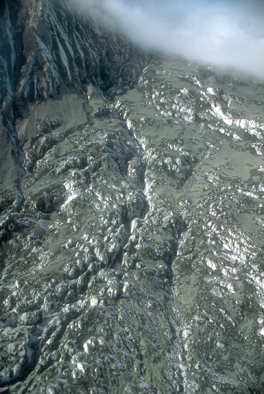
Hot pyroclastic debris from the September 16 to 17, 1992, eruption of the Crater Peak vent, Mount Spurr volcano, melted deep channels into the crevassed Kidazgeni Glacier. The debris combined with meltwater to produce mudflows or lahars that reached the Chakachatna River, 7 km (4 mi) distant. Photograph by C. Neal, U.S. Geological Survey, September 24, 1992.
Volcano(es): Spurr
Photographer: Neal, C. A.
URL: avo.alaska.edu/image/view/327
Credit: Image courtesy of AVO / U.S. Geological Survey.
Use Restriction: Please cite the photographer and the Alaska Volcano Observatory/U.S. Geological Survey when using this image.
Full Resolution.
Crater Peak 1992/9
For 220 pages of information on the three 1992 eruptions of Crater Peak, please see the USGS Bulletin 2139, available online at: https://www.avo.alaska.edu/pdfs/B2139.pdf ; this file is 9 MB.
From Eichelberger and others (1995): "Following the August eruption, deep seismicity gradually increased, and by mid-September it had returned to levels comparable to mid-June. AVO teams visiting the crater on September 7 and 16 noted nothing unusual. At about 7:30 p.m. ADT on September 16, however, discrete seismic events and weak tremor were detected by the newly reinstalled crater rim station. Tremor amplitude increased at 10:25 p.m. ADT, and at 10:33 p.m. ADT, AVO declared concern color code Red and began the emergency calldown. An eruption began at 10:36 p.m. ADT that lasted 11 minutes. Incandescence was recorded on the video camera at AVO-Anchorage and on the telemetered slow-scan television camera at Kasilof, 120 km southeast of Crater Peak just south of Kenai on the Kenai Peninsula. Weak tremor through the next hour foreshadowed the main phase of the eruption, which began at 12:03 a.m. ADT on September 17. Intermittent bright incandescence could be seen from Anchorage.
"The September 17 eruption lasted 3.6 hours. Pyroclastic flows swept down the south-southeast and southeast flanks of Crater Peak and mixed with snow and ice to become lahars. These flows were similar in appearance to pyroclastic flows, but they were cool and water saturated hours after emplacement. Tephra fallout on the Kidazgeni Glacier generated a debris flow that temporarily dammed the Chakachatna River. Once again, a narrow ballistic field extended at least 10 km from the vent along the south margin of the tephra plume. The eruption closed with a strong swarm of about 50 VT [volcano-tectonic] shocks between 5 and 10 km in depth, which may reflect readjustment of the conduit after magma withdrawal.
"The plume moved eastward, dusted the north edge of Anchorage and deposited about 1.5 mm of ash in Palmer, Wasilla, and nearby communities in the Matanuska-Susitna Valley north of Anchorage. Very light ashfall was reported in the town of Glenallen, 350 km east of Crater Peak."
Eichelberger and others (1995) state that this eruption produced 56 million cubic m of tephra (15 million m Dense Rock Equivalent).