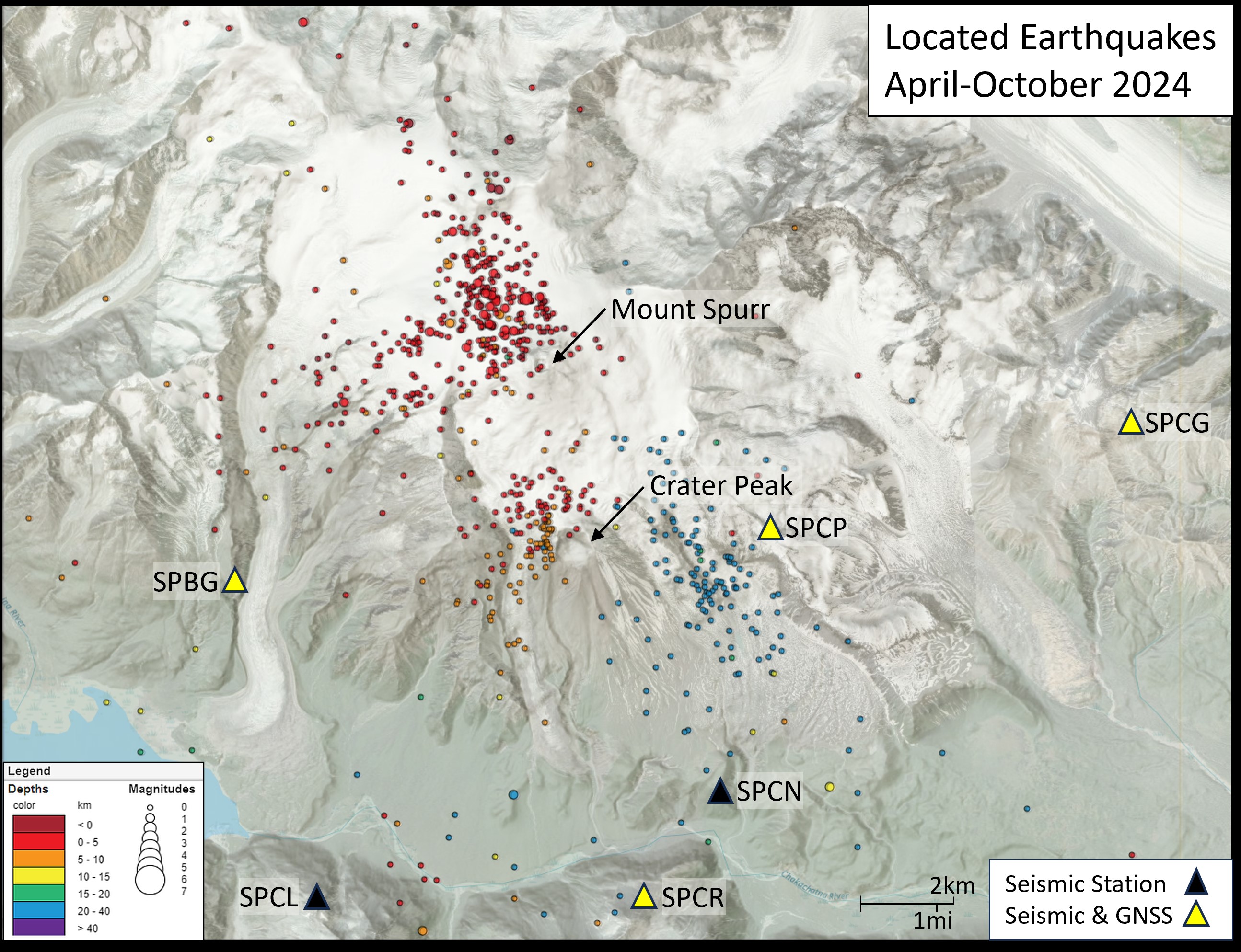
Located earthquakes near Mount Spurr, Alaska, April through October 8, 2024. Earthquake locations are colored by depth, with shallow earthquakes appearing red and deeper earthquakes are blue. Larger dots indicate higher magnitude earthquakes; the largest earthquake on this figure is a M2.3. Triangles indicate the locations of AVO's monitoring sites, colored by equipment at the specific site. Black triangle denote a location of a seismometer, and yellow triangles mark sites with co-located seismometers and GNSS. GNSS stands for Global Navigation Satellite System receiving sites that use signals from the Global Positioning System and other satellite constellations to precisely measure the position on the Earth in three dimensions (north-south, east-west, and vertical).
Volcano(es): Spurr
Photographer: Schneider, David
URL: avo.alaska.edu/image/view/196118
Credit: Image courtesy of AVO/USGS.
Use Restriction: Please cite the photographer and the Alaska Volcano Observatory / U.S. Geological Survey when using this image.
Full Resolution.
Spurr unrest 2024
On October 16, 2024, AVO raised the color code and alert level to YELLOW/ADVISORY, stating: "AVO has observed a gradual increase in volcanic unrest over a period of several months at Mount Spurr, located about 120 km (75 miles) west of Anchorage (https://avo.alaska.edu/image/view/196123). GNSS receivers have detected sustained upward and outward ground deformation since March 2024. An increase in seismic activity has also been noted since April (https://avo.alaska.edu/image/view/196122). Other indications of elevated activity include the development of a small lake in the summit crater in early summer of 2024.
"The largest magnitude earthquake detected in this current period of unrest is a M2.3 earthquake on October 6th. This increase in activity was described in detail in an Information Statement (https://avo.alaska.edu/news/hans/DOI-USGS-AVO-2024-10-09T19:43:26+00:00) that AVO released on October 9th. Analysis of seismic data indicates a subtle increase in the rate and size of earthquakes over the past few weeks. Because this is a notable departure from the normal background seismicity of the volcano, AVO is raising the Aviation Color Code to YELLOW and the Volcano Alert Level to ADVISORY. However, there are no indications that an eruption is imminent. Often this type of seismicity and ground deformation will decline without producing an eruption.
"AVO continues to closely monitor activity at Mount Spurr for signals that would indicate that the volcano is moving closer to an eruption. Based on previous eruptions, changes from current activity in the earthquakes, ground deformation, summit lake, and fumaroles would be expected if magma began to move closer to the surface. Therefore, it is very likely that if an eruption were to occur it would be preceded by additional signals that would allow advance warning. "
Over the following two weeks, there were more than 180 small earthquakes at Mount Spurr. Over the week of November 1st, there were also a few episodes of possible volcanic tremor, which might indicate deep fluid movement. No unusual activity or surface changes were observed in satellite data or webcam views. AVO staff visited on October 24th to conduct pre-winter maintenance on Spurr’s monitoring network and noted that the fumaroles (steam/gas vents) in Spurr summit’s crater were steaming.
Over the following weeks, earthquakes continued at varying rates, as is typical during periods of unrest. Steam was occasionally visible rising from Spurr’s summit during clear weather. On December 10, there was a M2.8 earthquake beneath the summit, and a few more episodes of tremor were recorded that week.
On Wednesday, December 18, AVO staff conducted a gas flight at Mount Spurr. Measurements of H2O, SO2, H2S, and CO2 were collected. Results were similar to the previous gas flight conducted on June 23, 2024. Personnel also took images and video during the flight that allowed accurate measurements of the crater lake that formed this year, showing that it has grown considerably since June despite the transition into winter. No activity was observed at Crater Peak.
As the new year turned, there were some notable periods of increased earthquake activity within the context of the larger unrest episode. The week of January 3, 2025, over 260 earthquakes were located, the largest being an M2.9 on January 2. Meanwhile, GPS data continued to show slow, steady inflation of the ground surface. Satellite radar data the week of January 10 showed that the crevasses in the summit crater were widening, demonstrating continued heat input to the area.
During late January, the monitoring network at Mount Spurr experienced some issues transmitting data back to AVO due to poor weather, not unusual for this time of year.
On January 31, AVO reported that over the past few weeks more of the ongoing earthquakes had clustered under Crater Peak, the vent that produced the 1953 and 1992 eruptions.
On February 6, AVO released an Information Statement detailing the activity since the color code change in October. The statement noted that over 2700 earthquakes had been detected to date during the period of unrest, which as of this date was ten months long. Movement of the ground surface near the area of Spurr was now about 2.4 inches total, as measured at the closest monitoring station to the mountain. Based on the earthquakes, deformation, growth of the lake in the Spurr summit crater, and low levels of volcanic gases measured, AVO rated the odds of no eruption and a future eruption at the Crater Peak vent as equally likely, with an eruption from Spurr summit less likely. However, additional signs of unrest would be expected in the lead up to an eruption.
On February 7, AVO staff visited the Spurr monitoring network to clear snow and ice from the instruments. They also collected additional volcanic gas measurements which showed no significant changes since the previous gas flight in December.
The remaining weeks of February followed the same general trends, with earthquake rates varying quite a bit while other signs of unrest-deformation and occasional steaming from the summit-remaining consistent. Fewer earthquakes were located close to Crater Peak.
On March 7 and March 11, AVO conducted flights to once again measure any volcanic gases emitted by Spurr. These flights, while consistent with one another, yielded considerably altered results from the previous flights. Elevated levels of sulfur dioxide and carbon dioxide were measured at Spurr summit, while very high levels of carbon dioxide were measured at Crater Peak. Staff also observed newly reactivated fumaroles within Crater Peak. These new changes led AVO to release an Information Statement on March 12 stating that likelihood of an eruption had increased and that AVO considered an eruption similar to 1953 and 1992 at Crater Peak to be the most likely outcome of the current unrest episode.
On March 17, AVO staff visited the Spurr monitoring network to conduct maintenance and clear the snow and ice from the CKT webcam. A new webcamera (SPCR cam) was installed at the same station on a tall mast to permanently resolve the problem with snow burial of the CKT cam, though the new feed took a few days to become available.
On March 21, another gas measurement flight occurred. Results were similar to the flights on March 7 and 11.
In the latter half of March and first part of April, earthquake rates decreased somewhat relative to early in the month. Ground deformation also slowed. However, occasional steam plumes were still visible originating at the summit. A long period of poor weather prevented gas measurement flights and limited satellite and webcam observations.
On April 17, AVO released another information statement stating that due to decreasing earthquake and deformation rates relative to early March, AVO believed that the chance of an eruption had decreased somewhat, though one was still possible. The availability of a new livestreaming camera viewing Spurr from Anchorage was also announced.
On April 23, an AVO field crew conducted maintenance on the Spurr monitoring network, but wind conditions were not suitable for gas measurements. On April 24 a repeat flight was able to take gas measurements, with results once again similar to the three gas flights in March.
During the second half of April, earthquake rates remained lower than in early March, though still above background, and deformation remained slower as well.
The rate of earthquakes and pause in deformation continued into early May. During the week of May 16, another monitoring network maintenance trip was performed, but conditions did not allow for gas measurements. During that week, earthquake numbers increased slightly, and they continued to increase for the week following as well, though rates still remained below the peak in early 2025. Sulfur dioxide emissions were more regularly observed in satellite data, and vapor plumes from Spurr summit were visible during good weather.
On May 23, AVO was able to conduct another gas measurement flight. Results were roughly similar to those in late April. The field crew observed steaming and degassing at fumaroles in both the Spurr summit crater and within Crater Peak, which was consistent with other recent field observations.
In the May 30 weekly update, AVO included a statement that said the magma intrusion driving the unrest at Spurr had most likely stalled, as demonstrated by the reduced deformation rates and declining seismicity.
During the month of June, earthquake rates continued to be lower than in early 2025. For the first three weeks of June, slightly over 40 earthquakes were located each week. In the last week of June, that number declined to just 17. On June 11, another gas measurement flight found similar results to the previous one on May 23. On June 19, AVO staff installed a semi-permanent gas monitor on the rim of Crater Peak, which returned consistent measurements with the gas measurement flights when the wind direction allowed. Staff also installed a second livestream camera in June close to Spurr at station SPCL.
Things continued much the same in July, with modest earthquake activity, occasional observations of gas emissions when conditions allowed, and no sign of continuing deformation. On July 29, AVO released another Information Statement, which summarized the gradually decreasing unrest and how chances of an eruption had also decreased.
In August, earthquake numbers continued to decline, ground deformation remained paused, and steaming remained minor. Gas emissions were still present, but decreased. On August 20, 2025, AVO lowered the Volcano Alert Level to NORMAL and the Aviation Color Code to GREEN, stating:
“Over the past several months, signs of volcanic unrest at Mount Spurr—including small earthquakes, gas emissions, melting ice, and surface changes—have been gradually decreasing. No ground deformation has been detected since March 2025. Taken together, this means that the movement of magma toward the surface, which began in early 2024, has stopped. As a result, the chances of an eruption in the near-term are now considered extremely low.
“Because of this, the Alaska Volcano Observatory (AVO) is lowering the Aviation Color Code to GREEN and the Volcano Alert Level to NORMAL, indicating that the volcano is currently quiet.
“Small earthquakes are still occurring more frequently than before the unrest began in February 2024, and volcanic gases are still being released from the summit crater and the Crater Peak vent on the south flank of the volcano. This is normal for volcanoes where magma has moved upward but has not erupted. Minor gas emissions and a slightly higher number of small earthquakes could persist for many months to several years.
“Although the potential for an eruption occurring in the near-term has passed, the volcano poses hazards for recreators on Mount Spurr. High levels of carbon dioxide gas detected on the rim of Crater Peak suggest that hazardous amounts of this odorless and colorless gas may be present within the crater, but not in local communities."