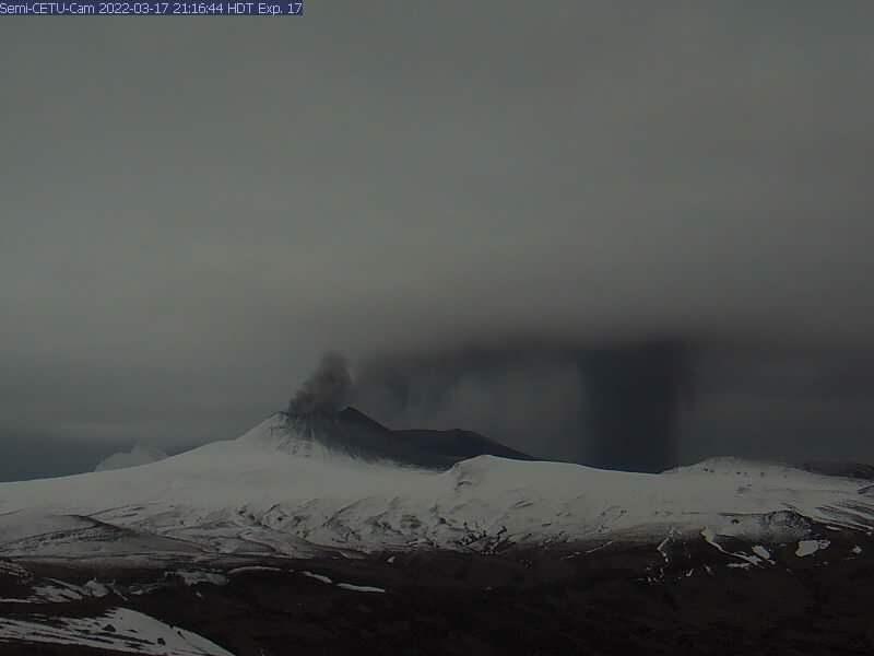
Eruption plume with textbook ash fallout as seen from the Semi_CETU webcam.
Volcano(es): Semisopochnoi
Photographer: Saunders-Shultz, Che Pascal
URL: avo.alaska.edu/image/view/182171
Location:
Latitude: 51.9649
Longitude: 179.4922
Semi_cetu webcam
Use Restriction: Please cite the photographer and the Alaska Volcano Observatory / University of Alaska Fairbanks, Geophysical Institute when using this image.
Full Resolution.
Semisopochnoi 2021/2
From Orr and others, 2024: "Eruptive activity at Semisopochnoi Island, which began in September 2018, was characterized in 2021 by frequent, low-level ash emissions and explosions from the north cone of Mount Young. An equipment failure on Amchitka Island meant that activity observations during the first half of the year were limited to those from satellite imagery and regional infrasound and seismic stations. In early June 2021, the equipment on Amchitka Island was repaired and the local network on Semisopochnoi Island was completely upgraded. These upgrades involved a change from analog to digital telemetry; the replacement of short-period vertical-component seismometers with three-component broadband seismometers; the addition of broadband infrasound sensors at stations CERB, CESW, and CEPE; and the addition of webcams at stations CEPE and CETU. A six-element infrasound array was also installed on Amchitka Island in late May 2021 to provide improved regional monitoring.
"Seismic activity was low prior to the network outage; thus, the first activity noted in 2021 was a satellite observation of a small ash deposit from the north cone of Mount Young on February 6. In response, AVO raised the Aviation Color Code and Volcano Alert Level from UNASSIGNED to YELLOW and ADVISORY the next day. Ash emissions appeared in satellite imagery on February 8, which led AVO to further elevate the volcano to ORANGE and WATCH.
In the following months, satellites recorded intermittent ash emissions and regional infrasound sensors detected small explosions. Ash emissions increased considerably on April 16, when an ash cloud as high as ~20,000 ft (~6,100 m) ASL extended more than 350 km [220 mi] from the north cone of Mount Young. This change prompted AVO to raise the Aviation Color Code and Volcano Alert Level from ORANGE and WATCH to RED and WARNING. The next day, ash emissions declined and the volcano was lowered back to ORANGE and WATCH. Satellite imagery and regional infrasound sensors recorded intermittent, small explosions over the next few months.
"Seismicity was initially low after the local geophysical sensors were restored in June, but both seismicity and the number of discrete explosions increased into July and August. Seismic activity remained elevated, although variably so, for the rest of the year, during which time tremor and explosion signals dominated the data. On September 20, increased ash emissions observed in satellite imagery again prompted AVO to raise the Aviation Color Code and Volcano Alert Level from ORANGE and WATCH to RED and WARNING. A large SO2 cloud associated with this increase in activity appeared in TROPOMI satellite data. The following day, ash emissions declined, and Semisopochnoi Island was lowered to ORANGE and WATCH. The activity at the volcano for the rest of the year consisted of low-level ash emissions, seismic tremor, phreatomagmatic explosions, and many satellite SO2 detections.
"In combination with carrying out geophysical maintenance, AVO geologists sampled ash deposits on Semisopochnoi Island on May 30 and June 1. Tephra samples were collected across all parts of the island, but the samples most proximal to Mount Young, taken from a 4-cm-thick [1.6-in-thick] deposit, were from 1.6 km [1 mi] southwest of the center of the north cone. The tephra was fine-grained, easily remobilized, and present over the entire island except along the north coast. The coarsest grains in the samples were less than 4 mm [0.16 in] in diameter. Approximately 50 percent of the material was less than 50 micrometers [0.002 inches] in diameter. No larger ballistic particles were observed, including on the flanks of the north cone. The internal structures of deposits were not preserved; thus, the samples represent a bulk aggregate of deposits from throughout the spring of 2021.
"A microscopic analysis of the samples showed that they are mostly crystal-lithic grains or loose crystals. A minor proportion of the grains are scoriaceous juvenile material characterized by low vesicularity and microlitic glass. Microlite phases comprise plagioclase, clinopyroxene (augite and pigeonite), orthopyroxene, and iron-titanium oxides."
Frequent low-level ash emissions and small explosions continued through the first half of 2022. Starting June 12, there was a pause in activity that led AVO to reduce the alert level and color code to YELLOW/ADVISORY on July 8, but they were increased again to ORANGE/WATCH on August 21, after a renewal of activity. On that day ash emissions reached almost 20,000 ft asl.
Minor eruptive activity continued through mid-September. On September 29, AVO again lowered the color code and alert levels to YELLOW/ADVISORY due to an eruptive pause and a decline in seismic activity.
Starting on October 31, a few small explosions occurred. This, along with tremor starting on November 5, led AVO to raise the alert levels to ORANGE/WATCH once more on November 7. A partial network outage starting that day reduced AVO's ability to track the eruption, but frequent steam plumes were observed in this period.
Due to a lack of ash emissions or explosions, AVO reduced the alert levels to YELLOW/ADVISORY on November 23.
On December 27, webcam images showed fresh ash on the snow and a steam plume. The alert levels were raised to ORANGE/WATCH on December 28, 2022.
Ash deposits and explosion signals continued into mid January, 2023. Steam plumes and seismic activity continued after that, but the lack of explosive activity caused AVO to lower the alert levels to YELLOW/ADVISORY on February 22, 2023.
On March 19, fresh ash was once again seen in webcam images, and explosions were detected. The alert levels were returned to ORANGE/WATCH. Minor eruptive activity continued through early May.
On May 17, the alert levels were lowered to YELLOW/ADVISORY.
No further eruptive activity was observed after this. Seismic activity declined to low levels as well. The alert levels were lowered to GREEN/NORMAL on August 3, 2023.