Steller 2005/9
Start: September 14, 2005 [1]
Event Type: Not an eruption
Description: From Huggel (2009): "One of the largest rock-ice avalanches in the past several decades occurred on Mt. Steller in south-central Alaska (3236 m asl, 60 degrees 13 minutes N, 143 degrees 05 minutes W) on September 14, 2005. The headscarp of the avalanche is located at 3100 m asl in the glacier-covered south flank of Mt. Steller. The total volume of rock and ice that failed and was entrained along the avalanche path is 40-60x10^6 m cube. The avalanche traveled 9 km and came to rest on Bering Glacier (Fig. 7 [in original text]; Huggel and others, 2008). Tertiary sedimentary rocks layered sub-parallel to the surface slope characterize the failure zone. Due to its remote location, the avalanche was only detected by seismic signal. The seismic impact of the slide was so strong that it was detected around the world."
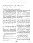
From Huggel and others (2012): "Field surveys have shown that the flowing mass was composed of (i) the initial collapsing rock-ice mass estimated to be made up of 3-4.5 Mm cubed of ice, 2 Mm cubed of snow and 10-20 Mm cubed of rock [Huggel and others, 2008] and (ii) material eroded from the glacier along the avalanche path. The only available constraint on the deposit is its area, with an uncertainty of maximum 5% on the runout distance (Figure 1b [in original text])"
"The seismic signal generated by the avalanche was recorded by 7 broadband seismic stations covering a wide range of azimuths and source-station distances (37-623 km) (Figure 1a [in original text]). Figures 1c and 1d [in original text] show the typical emergent onset of landslide generated seismic signals; the signal lasts about 130 s at BERG station. At all the stations, the spectrogram has a characteristic cigar shape with a frequency content f∈ [0.004, 1.5] Hz, similar to the seismic signal generated by the Thurwieser landslide [Favreau and others, 2010]."
References Cited
[1] Recent extreme slope failures in glacial environments: effects of thermal perturbation, 2009
Huggel, Christian, 2009, Recent extreme slope failures in glacial environments: effects of thermal perturbation: Quaternary Science Reviews, v. 28, n. 11-12, p. 1116-1130, doi:10.1016/j.quascirev.2008.06.007.[2] Numerical modeling of the Mount Steller landslide flow history and of the generated long period seismic waves, 2012
Moretti, L., Mangeney, A., Capdeville, Y., Stutzman, E., Huggel, C., Schneider, D., and Bouchut, F., 2012, Numerical modeling of the Mount Steller landslide flow history and of the generated long period seismic waves: Geophysical Research Letters, v. 39, n. 16, 10 p., doi:10.1029/2012GL052511 .Complete Eruption References
Numerical modeling of the Mount Steller landslide flow history and of the generated long period seismic waves, 2012
Moretti, L., Mangeney, A., Capdeville, Y., Stutzman, E., Huggel, C., Schneider, D., and Bouchut, F., 2012, Numerical modeling of the Mount Steller landslide flow history and of the generated long period seismic waves: Geophysical Research Letters, v. 39, n. 16, 10 p., doi:10.1029/2012GL052511 .
Recent extreme slope failures in glacial environments: effects of thermal perturbation, 2009
Huggel, Christian, 2009, Recent extreme slope failures in glacial environments: effects of thermal perturbation: Quaternary Science Reviews, v. 28, n. 11-12, p. 1116-1130, doi:10.1016/j.quascirev.2008.06.007.
