Pavlof 1866/3
Start: March 14, 1866 [1]
Event Type: Explosive
Max VEI: 2 [2]
Description: The exact location of this eruption is uncertain, but nearly all compilers (Sapper, 1917; Coats, 1950; Hantke, 1955; Powers, 1958; Jacob and Hauksson, 1983; Simkin and Siebert, 1994; Miller and others, 1998) attribute it to Pavlof. Doroshin (1870) appears to be the original source for this eruption.
Kisslinger (1983), translating Doroshin (1870), reports that "At about 3 a.m. on March 14 [March 26, Gregorian calendar], 1866, at Pavlof Harbor on Kodiak Island there was impenetrable darkness for 15 minutes, and ash fell. It was completely silent while this happened. According to reports from Afognak Island, and from the village of Katmai on the Alaska Peninsula where the same thing was experienced, the cloud of ash moved from the south, probably as the result of an eruption of one of the voclanoes of the Alaska Peninsula. Ash fell at Pavlof Harbor to a depth of one-quarter inch. There was neither a noise nor an earthquake at the time of this occurrence.
"From reprots obtained recently, the place of eruption has been determined more definitely; it occurred to the northwest of Katmai village, on the Alaska Peninsula, at a newly formed volcano. In fact, the smoking volcano Kutliukhat [Mount Katmai] is located in the aforesaid direction."
Although Doroshin seems to suggest that the place of eruption was *not* Pavlof, but instead somewhere farther north, the ashfall distribution pattern, prevailing winds, and tephra deposits in the Katmai area do not support this theory. The most likely volcano to have deposited 1/4 of an inch worth of ash at Pavlof Harbor is a volcano near Pavlof Harbor (Judy Fierstien, 2006, personal communication.) Although Doroshin indicates that Pavlof Harbor is on Kodiak Island, modern references to Pavlof Harbor concern a harbor near Pavlof Volcano.
Sapper (1917) reports a strong ash eruption in March, 1866, citing Fuchs, and Mercalli, after Perrey. No mention of this eruption is found in Becker (1898).
References Cited
[1] Some volcanoes, volcanic eruption, and earthquakes in the former Russian America. Peter Doroshin's account of volcanic activity and earthquakes between 1840 and 1866, 1983
Kisslinger, J.B., 1983, Some volcanoes, volcanic eruption, and earthquakes in the former Russian America. Peter Doroshin's account of volcanic activity and earthquakes between 1840 and 1866: Pacific Northwest Quarterly, v. 74, n. 2, p. 59-68.[2] Volcanoes of the world [2nd edition], 1994
Simkin, Tom, and Siebert, Lee, 1994, Volcanoes of the world [2nd edition]: Tucson, Arizona, Geoscience Press, 349 p.[3] Katalog der geschichtlichen vulkanausbruche, 1917
Sapper, Karl, 1917, Katalog der geschichtlichen vulkanausbruche: Strassburg, Germany, Karl J. Trubner, 358 p.[4] Alaska Peninsula-Aleutian Islands, 1958
Powers, H. A., 1958, Alaska Peninsula-Aleutian Islands: in Williams, H., (ed.), Landscapes of Alaska, Los Angeles, CA, University of California Press, p. 61-75.[5] A seismotectonic analysis of the seismic and volcanic hazards in the Pribilof Islands - Eastern Aleutian Islands Region of the Bering Sea, 1983
Jacob, K. H., and Hauksson, Egill, 1983, A seismotectonic analysis of the seismic and volcanic hazards in the Pribilof Islands - Eastern Aleutian Islands Region of the Bering Sea: Lamont-Doherty Geological Observatory of Columbia University Annual Report NOAA 03--5-022-70, New York, 224 p.[6] Volcanic activity in the Aleutian Arc, 1950
Coats, R. R., 1950, Volcanic activity in the Aleutian Arc: U.S. Geological Survey Bulletin 0974-B, p. 35-49, 1 sheet, scale 1:5,000,000.Complete Eruption References
Catalog of the historically active volcanoes of Alaska, 1998
Miller, T. P., McGimsey, R. G., Richter, D. H., Riehle, J. R., Nye, C. J., Yount, M. E., and Dumoulin, J. A., 1998, Catalog of the historically active volcanoes of Alaska: U.S. Geological Survey Open-File Report 98-0582, 104 p.

Volcanoes of the world [2nd edition], 1994
Simkin, Tom, and Siebert, Lee, 1994, Volcanoes of the world [2nd edition]: Tucson, Arizona, Geoscience Press, 349 p.
The eruptive activity, seismicity, and velocity structure of Pavlof volcano, Eastern Aleutians, 1985
McNutt, S. R., 1985, The eruptive activity, seismicity, and velocity structure of Pavlof volcano, Eastern Aleutians: Columbia University unpublished Ph.D. dissertation, 214 p.
A seismotectonic analysis of the seismic and volcanic hazards in the Pribilof Islands - Eastern Aleutian Islands Region of the Bering Sea, 1983
Jacob, K. H., and Hauksson, Egill, 1983, A seismotectonic analysis of the seismic and volcanic hazards in the Pribilof Islands - Eastern Aleutian Islands Region of the Bering Sea: Lamont-Doherty Geological Observatory of Columbia University Annual Report NOAA 03--5-022-70, New York, 224 p.
Some volcanoes, volcanic eruption, and earthquakes in the former Russian America. Peter Doroshin's account of volcanic activity and earthquakes between 1840 and 1866, 1983
Kisslinger, J.B., 1983, Some volcanoes, volcanic eruption, and earthquakes in the former Russian America. Peter Doroshin's account of volcanic activity and earthquakes between 1840 and 1866: Pacific Northwest Quarterly, v. 74, n. 2, p. 59-68.
Alaska Peninsula-Aleutian Islands, 1958
Powers, H. A., 1958, Alaska Peninsula-Aleutian Islands: in Williams, H., (ed.), Landscapes of Alaska, Los Angeles, CA, University of California Press, p. 61-75.

Uebersicht ueber die vulkanische Taetigkeit 1948-1950, 1955
Hantke, Gustav, 1955, Uebersicht ueber die vulkanische Taetigkeit 1948-1950: Bulletin Volcanlogique, v. 14, p. 151-184.

Volcanic activity in the Aleutian Arc, 1950
Coats, R. R., 1950, Volcanic activity in the Aleutian Arc: U.S. Geological Survey Bulletin 0974-B, p. 35-49, 1 sheet, scale 1:5,000,000.
Katalog der geschichtlichen vulkanausbruche, 1917
Sapper, Karl, 1917, Katalog der geschichtlichen vulkanausbruche: Strassburg, Germany, Karl J. Trubner, 358 p.

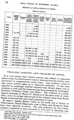
Reconnaissance of the gold fields of southern Alaska with some notes on general geology, 1898
Becker, G. F., 1898, Reconnaissance of the gold fields of southern Alaska with some notes on general geology: U.S. Geological Survey Annual Report 0018, p. 1-86, 6 sheets, scale unknown.