Geology
Geologic studies of a volcano help AVO characterize the nature, frequency, and magnitude of past eruptions, which are then integrated to assess likely future hazards. Geologic studies of a volcano typically result in a geologic map, a volcano hazard assessment, and models that interpret dynamics and eruptive processes of the underlying magmatic system. Hazard assessments include a description of the eruptive history of a given volcano, explanations of likely eruption scenarios, and determination of probable impact zones for the range of expected hazards.
Because most Alaska volcanoes are remote, and the field season is short, geologic field work is typically conducted over several summer seasons. Laboratory investigations help determine the physical and geochemical characteristics and age of the volcanic deposits. AVO's hazard assessments can be downloaded here: https://www.avo.alaska.edu/explore/search/hazards
For a taste of what geologic mapping is like for Alaska volcanoes, here is a daily blog about mapping Makushin during the summer of 2015. https://www.avo.alaska.edu/news/view/makushin-2015-geology-blog
Geologic Mapping
Every volcano has a unique personality—for example some produce frequent low explosivity lava flows, some erupt lava domes along with occasional moderate-sized explosions, and some have infrequent but extremely violent and large explosions. Many volcanoes produce a combination of these eruptive styles, especially over their geologic lifetime. A map of the geologic deposits around a volcano provides a blueprint for understanding its past behavior, which in turn informs expectations for future eruptions.
In Alaska, geologic mapping is mostly helicopter-based and relies on extensive study of aerial and satellite imagery supplemented by field observations. Geologists spend many hours traveling to different rock outcrop locations on and around the volcano edifice to document what type of deposits they find, where they are located, how old each deposit is, and how much ground they cover (how far they traveled away from the volcano). Different types of deposits mapped during the fieldwork include lava flows from lower explosivity eruptions, pyroclastic flows from moderate to highly explosive eruptions, volcanic mudflow deposits (lahars), and volcanic landslide or debris avalanche deposits. The observations from the fieldwork are compiled onto a topographic map or digital elevation model, using Geographical Information Systems tools. Samples of lava flows, explosive deposits, and soil samples from the field are analyzed in the laboratory for composition and age. This information is then synthesized to profile a volcano’s past, and thus potential future, behavior.
During the summer of 2005, an AVO geologist made a one-day stop at very remote Kasatochi Island in the western Aleutian Islands. This visit was prompted by effervescence and roiling noted in the crater lake by U.S. Fish and Wildlife Service biologists. During her visit, the AVO geologist recognized widespread, geologically young pyroclastic deposits on the volcano, revealing geologically recent eruptive activity. After the large Kasatochi 2008 eruption, AVO geologists returned to Kasatochi Island, and created a detailed geologic map of Kasatochi Island, published in 2017. This map details not just the ages, character, and extent of different volcanic products on Kasatochi Island, but also geomorphic change related to the eruption and post-eruptive erosion.

Petrology
Petrology of volcanic rocks is the study of the chemistry, mineral content, and texture of lavas and pyroclasts in order to understand the magmatic system and eruption processes at a volcano. AVO geologists typically investigate rocks through:
Bulk rock chemistry: rock crushed into a fine powder that is analyzed for major elements (expressed as oxides, i.e., SiO2, K2O, etc.), trace elements, and occasionally isotopes. Bulk chemistry is used to classify volcanic rocks and understand magma origins in a suite of rocks from a volcano.

Rock thin sections: samples mounted on a glass slide and polished to around 30 μm thickness, smaller than the thickness of a human hair. The sections of rock are thin enough to allow light to pass through, so they can be examined in detail. Minerals and textures can be documented through optical or electron microscopes. Similar to tree rings, minerals grow concentrically and change in chemistry according to changes in the environment in the magma chamber. Minerals thus record the history of a magma.

In-situ chemistry techniques, including electron microprobe, laser ablation, and secondary ion mass spectrometry. These tools allow analysis of individual minerals and volcanic glass at very fine scales, down to about 1 micron resolution, to complement bulk analysis.

The petrology of a volcano is used to understand what types of magmas drive eruptions and where in the Earth’s crust or mantle they are generated. Thus petrology, coupled with geophysics, allows geologists to understand the plumbing underneath a volcano.
Tephra Studies
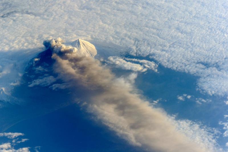
Volcanic ash is the principal hazard form Alaska volcanoes, and therefore is a primary area of research of AVO scientists. Volcanic-ash hazards are far reaching and disruptive, affecting more people, infrastructure, and daily activities than any other eruptive phenomena. AVO geologists work to improve our understanding of the frequency and distribution of ash-producing eruptions in Alaska. For more information on ash hazards, visit our Volcanic Hazards Page. The USGS-sponsored Volcanic Ashfall Impacts Working Group offers resources and guidance for ashfall preparedness and impact.
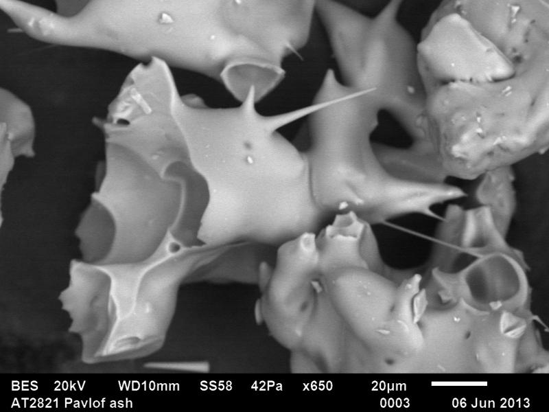
Rock fragments that are explosively ejected from a volcano during an eruption are called tephra. When tephra fragments are large (>64 mm), they are called blocks and bombs. Moderate sized fragments (2-64 mm) are termed lapilli and the smallest particles (<2 mm) are termed volcanic ash.
Tephra studies are a key component in understanding the magnitude and
the frequency of volcanic eruptions and helping to improve volcanic
ashfall hazard assessments. In addition, tephrostratigraphy is an
integral part of linking marine, lacustrine, and terrestrial records to
aid research in paleoclimate studies and archaeology.
Alaska Tephra Lab
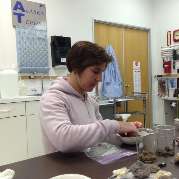
The USGS/AVO Alaska Tephra Laboratory (ATL) and Data Center is an interdisciplinary center for the study of tephra fall (volcanic ash) erupted from Alaskan volcanoes and serves as a regional facility for the storage and management of tephra data. The ATL houses data and physical archives including a growing reference collection for the USGS/AVO and its collaborators.
The goal of the ATL is to characterize tephra deposits erupted from Alaska’s volcanoes in terms of field context and physical and chemical characteristics, and to curate samples and data for long-term use. The ATL has a laboratory for performing routine tephra analyses, where standard protocols are employed for sample characterization so that datasets are comparable. Due to the interdisciplinary nature of tephra studies, many projects involve collaborators from within the Alaska Volcano Observatory team, other government agencies, and universities across the nation.
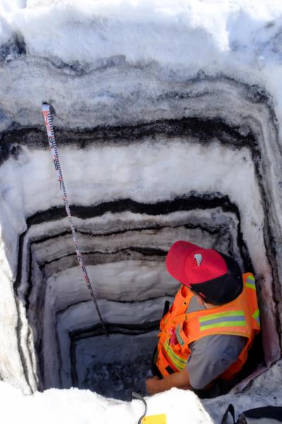
The ATL holdings include mainly Holocene-age tephra samples and datasets from many Alaska volcanoes, and also include a reference data set of tephra from the largest eruptions of Holocene age in Alaska, which were primarily caldera-forming eruptions. Numerous regional tephra records where lake or peat cores were used to assess ashfall frequency and magnitude over larger regions are also part of the collection.
AVO’s Geologic Database of Information on Volcanoes in Alaska (GeoDIVA)
The GeoDIVA database provides the back end to AVO’s public website, and houses comprehensive, authoritative information on Alaska volcanoes, supporting scientific investigations, crisis response, and public communications. It is a broad database, housing large amounts of interrelated geochemical and geological data, including:
sample metadata for more than 32,000 young volcanic samples, including storage locations.
detailed eruption and unrest histories of Alaska volcanoes from the present through the Pleistocene
more than 14,000 whole-rock geochemical analyses and 4,000 tephra glass analyses
more than 34,000 images, searchable by volcano, keyword, photographer, and more
In 2014 AVO began developing the Alaska Tephra Database project. The tephra database works seamlessly with other AVO database modules as part of the larger GeoDIVA. The end result is the first-ever comprehensive database of Alaska tephra (volcanic ash). This database will house all pertinent information on Alaska tephras necessary for sample processing, archiving, and scientific research. Use-goals for the database include:
correlating unknown samples to source volcanoes and publishing reference materials to improve tephra distribution maps
helping to answer questions of eruption frequency and magnitude
providing a resource for identifying samples for more in-depth studies (e.g. petrologic, impacts, etc.)
Developing correlations of tephra records across Alaska and the northern hemisphere requires an understanding of the age, chemistry, and character of tephra deposits. The Alaska Tephra Database now contains all published young Alaska volcanic glass geochemical averaged analyses, and has a user interface that allows computation of glass chemistry similarity coefficients for multiple tephra samples. The geochemical portion of the Alaska Tephra Database is queryable here: https://www.avo.alaska.edu/geochem/ We are now working on expanding the database to include sample preparation details, individual grain-point and mineral analyses, and creating a laboratory interface for post-field sample preparation.
If you are interested in submitting your tephra or whole-rock data to GeoDIVA, please email geodiva@avo.alaska.edu.