Segula
Legend
✕
| Red (Warning) | |
| Orange (Watch) | |
| Yellow (Advisory) | |
| Green (Normal) | |
| Uninstrumented | |
| Community | |
| Webcam | |
| Instrument | |
| Earthquake Magnitude | |
|
0
| |
| Earthquake Age | |
| Last 2 Hours | |
| Last 2 Days | |
| Last 1 Week | |
Facts
- Official Name: Segula Peak
- Seismically Monitored: No
- Color Code: UNASSIGNED
- Alert Level: UNASSIGNED
- Elevation: 1153m (3782ft)
- Latitude: 52.0138
- Longitude: 178.134
- Smithsonian VNum: 311030
-
Nearby Towns:
- Shemya Station 177 mi (284 km) NW
- Attu Station 216 mi (347 km) NW
- Adak 223 mi (359 km) SE
- Atka 325 mi (524 km) NE
- Nikolski 550 mi (885 km) NE
Distance from Anchorage: 1353 mi (2177 km)
Description
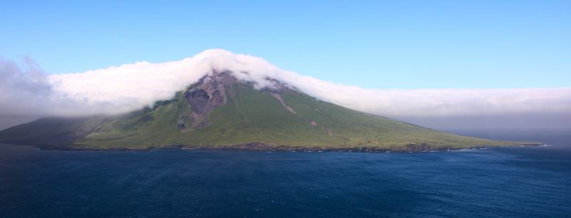
From Wood and Kienle (1990) [1] : "Segula volcano is built upon a 100-m-deep marine platform by the accumulation of flows and pyroclastic material emanating from a single center. Although there are no dated eruptions, some flows and pyroclastic deposits are so little weathered that ages of only a few hundred years are estimated. Pyroclastic material covers much of the cone's surface and a cinder cone resides in the middle of the summit crater."Name Origin
"Segula Peak" was published on a 1951 U.S. Geological Survey map. W.H. Nelson (1959) called it "Segula Volcano" (Orth, 1971).
References Cited
[1] Volcanoes of North America: United States and Canada, 1990
Wood, C. A., and Kienle, Juergen, (eds.), 1990, Volcanoes of North America: United States and Canada: New York, Cambridge University Press, 354 p.Loading Past Activity...
Loading Images...
Loading Maps...
Loading Bibliography...
Before an eruption
Ashfall & Preparedness Information
- Ashfall impacts & preparedness (US Geological Survey)
- Volcanic health hazards & impacts (International Volcanic Health Hazards Network)
- Ash Alert! Pamphlet (AK Division of Homeland Security & Emergency Management)
- Volcanic Ashfall (AK Department of Environmental Conservation, Division of Air Quality)