Kialagvik
Spurr
Great Sitkin
Akutan
Aniakchak
Atka volcanic complex
Augustine
Cleveland
Dutton
Edgecumbe
Fisher
Gareloi
Great Sitkin
Griggs
Iliamna
Isanotski
Kanaga
Katmai
Little Sitkin
Mageik
Makushin
Martin
Novarupta
Pavlof
Redoubt
Semisopochnoi
Shishaldin
Snowy
Spurr
Takawangha
Tanaga
Trident
Ugashik-Peulik
Ukinrek Maars
Veniaminof
Westdahl
Wrangell
Adagdak
Addington volcanic field
Alagogshak
Amak
Amchixtam Chaxsxii
Amukta
Andrew Bay volcano
Basalt of Gertrude Creek
Behm Canal-Rudyerd Bay
Black Peak
Bobrof
Bogoslof
Buldir
Buzzard Creek
Camille Cone
Capital
Carlisle
Chagulak
Chiginagak
Churchill, Mt
Cone 3110
Cone 3601
Dana
Davidof
Denison
Devils Desk
Double Glacier
Douglas
Drum
Duncan Canal
Emmons Lake Volcanic Center
Espenberg
Folsoms Bluff
Fourpeaked
Frosty
Gas Rocks, the
Gilbert
Gordon
Gosling Cone
Hayes
Herbert
Imuruk Lake Volc Field
Ingakslugwat Hills
Ingenstrem Depression Volcanic Field
Ingrisarak Mtn
Iron Trig cone
Iskut-Unuk River cones
Jarvis
Jumbo Dome
Kagamil
Kaguyak
Kasatochi
Kejulik
Kialagvik
Kiska
Klawasi Group
Knob 1000
Kochilagok Hill
Koniuji
Kookooligit Mountains
Koyuk-Buckland volcanics
Kukak
Kupreanof
Lone basalt
Maclaren River volcanic field
Moffett
Monogenetic QT vents of WWVF
Morzhovoi
Nelson Island
Nunivak Island
Nushkolik Mountain volcanic field
Okmok
Pavlof Sister
Prindle Volcano
Rainbow River cone
Recheshnoi
Roundtop
Sanford
Seguam
Segula
Sergief
Skookum Creek
St. George volcanic field
St. Michael
St. Paul Island
Steller
Stepovak Bay 1
Stepovak Bay 2
Stepovak Bay 3
Stepovak Bay 4
Suemez Island
Table Top Mtn
Tanada Peak
Tanax̂ Angunax̂
Tlevak Strait
Togiak volcanics
Uliaga
Ungulungwak Hill-Ingrichuak Hill
Unnamed (near Ukinrek Maars)
Vsevidof
Western Cones
Wide Bay cone
Yantarni
Yunaska
Legend
✕
| Red (Warning) | |
| Orange (Watch) | |
| Yellow (Advisory) | |
| Green (Normal) | |
| Uninstrumented | |
| Community | |
| Webcam | |
| Instrument | |
| Earthquake Magnitude | |
|
0
| |
| Earthquake Age | |
| Last 2 Hours | |
| Last 2 Days | |
| Last 1 Week | |
Facts
- Seismically Monitored: No
- Color Code: UNASSIGNED
- Alert Level: UNASSIGNED
- Elevation: 1575m (5167ft)
- Latitude: 57.2019
- Longitude: -156.7467
- Smithsonian VNum: 312120
-
Nearby Towns:
- Ugashik 32 mi (52 km) NW
- Kanatak 37 mi (59 km) NE
- Pilot Point 40 mi (64 km) NW
- Port Heiden 73 mi (117 km) SW
- Egegik 74 mi (119 km) NW
Distance from Anchorage: 368 mi (592 km)
Description
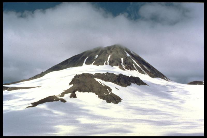
From Wood and Kienle (1990) [1] : "Kialagvik volcano is a small (~5 cubic km), poorly known central-vent volcano adjacent to, and in the same arc segment as Chiginagak volcano. The volcano is informally named after the Eskimo word for the adjacent Wide Bay. The published geologic map is at 1:250,000 scale; owing to remoteness and extensive snow and ice cover, little additional work has been done."The volcano is constructed partly on and adjacent to older, early Quaternary (?) or Tertiary hypabyssal and extrusive rocks from other vents; consequently, the exact extent of the deposits properly assigned to the Kialagvik vent is uncertain. Probable Kialagvik deposits comprise lava flows of andesitic composition and overlying dacitic block-and-ash flow deposits similar in composition to the Holocene (?) dome. Except for lacking an exposed stratovolcano edifice, Kialagvik has probably been most similar in eruptive style to Yantarni volcano to the southwest."
Name Origin
"Kialagvik volcano" is an informal name, derived from nearby Kialagvik Creek.
References Cited
[1] Volcanoes of North America: United States and Canada, 1990
Wood, C. A., and Kienle, Juergen, (eds.), 1990, Volcanoes of North America: United States and Canada: New York, Cambridge University Press, 354 p.Reported Activity
0 Event Date(s)
Past Activity Legend:
| Eruption | |
| Questionable eruption | |
| Non-eruptive activity |


Showing 1 - 6 of 6
Map Images
By:
U.S. Geological Survey
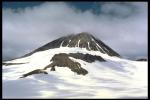
Topographic map of Chiginagak and Kialagvik.
Topographic map of Chiginagak and Kialagvik.
By:
U.S. Geological Survey
Topographic shaded relief map of Kialagvik Volcano, Alaska.
Topographic shaded relief map of Kialagvik Volcano, Alaska.
By:
Schaefer, J. R. G.
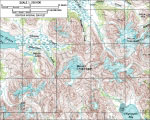
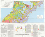
Alaska Peninsula volcanoes.
Alaska Peninsula volcanoes.
By:
Schaefer, Janet
Index map showing the location of Quaternary volcanoes on the Alaska peninsula.
Index map showing the location of Quaternary volcanoes on the Alaska peninsula.
Map References
Volcanoes of Alaska, 1998
Nye, C. J., Queen, Katherine, and McCarthy, A. M., 1998, Volcanoes of Alaska: Alaska Division of Geological & Geophysical Surveys Information Circular IC 0038, unpaged, 1 sheet, scale 1:4,000,000, available at http://www.dggs.dnr.state.ak.us/pubs/pubs?reqtype=citation&ID=7043 .

Volcanoes of Alaska, 1995
Alaska Division of Geological & Geophysical Surveys, 1995, Volcanoes of Alaska: Alaska Division of Geological & Geophysical Surveys Information Circular IC 0038, unpaged, 1 sheet, scale 1:4,000,000.
Geothermal resources of the Aleutian Arc, 1993
Motyka, R. J., Liss, S. A., Nye, C. J., and Moorman, M. A., 1993, Geothermal resources of the Aleutian Arc: Alaska Division of Geological & Geophysical Surveys Professional Report PR 0114, 17 p., 4 sheets, scale 1:1,000,000.

Holocene volcanoes of the Aleutian Arc, Alaska, 1993
March, G. D., 1993, Holocene volcanoes of the Aleutian Arc, Alaska: Alaska Division of Geological & Geophysical Surveys Public-Data File PDF 93-85, unpaged, 1 sheet, scale 1:2,000,000.
Map and tables showing geochronology and whole-rock geochemistry of selected samples, Ugashik and part of Karluk quadrangles, Alaska, 1992
Wilson, F.H., and Shew, Nora, 1992, Map and tables showing geochronology and whole-rock geochemistry of selected samples, Ugashik and part of Karluk quadrangles, Alaska: U.S. Geological Survey Miscellaneous Field Studies Map MF-1539-E, 34 p., 2 sheets, scale 1:250,000.
Hard Copy held by AVO at FBKS - CEC file cabinet
Mineral and energy resource assessment maps of the Ugashik, Bristol Bay and western Karluk quadrangles, Alaska, 1989
Church, S. E., Detterman, R. L., and Wilson, F. H., 1989, Mineral and energy resource assessment maps of the Ugashik, Bristol Bay and western Karluk quadrangles, Alaska: U.S. Geological Survey Miscellaneous Field Studies Map MF 1539-I, unpaged, 2 plates, scale 1:63,360.
Maps showing aeromagnetic survey and geologic interpretation of the Ugashik and part of the Karluk quadrangles, Alaska, 1988
Case, J. E., Detterman, R. L., Wilson, F. H., Chuchel, B. A., and Yount, M. E., 1988, Maps showing aeromagnetic survey and geologic interpretation of the Ugashik and part of the Karluk quadrangles, Alaska: U.S. Geological Survey Miscellaneous Field Studies Map MF 1539-D, 12 p., 2 plates, scale 1:250,000.
Quaternary geologic map of the Ugashik, Bristol Bay, and western part of Karluk quadrangles, Alaska, 1987
Detterman, R. L., Wilson, F. H., Yount, M. E., and Miller, T. P., 1987, Quaternary geologic map of the Ugashik, Bristol Bay, and western part of Karluk quadrangles, Alaska: U.S. Geological Survey Miscellaneous Investigations Series Map I 1801, unpaged, 1 sheet, scale 1:250,000, available online at http://www.dggs.dnr.state.ak.us/pubs/pubs?reqtype=citation&ID=12928 .
Geologic map of the Ugashik, Bristol Bay, and western part of Karluk quadrangle, Alaska, 1987
Detterman, R. L., Case, J. E., Wilson, F. H., and Yount, M. E., 1987, Geologic map of the Ugashik, Bristol Bay, and western part of Karluk quadrangle, Alaska: U.S. Geological Survey Miscellaneous Investigations Series Map I 1685, unpaged, 1 plate, scale 1:250,000.
Map showing distribution, composition, and age of Late Cenozoic volcanic centers in Alaska, 1986
Luedke, R. G., and Smith, R. L., 1986, Map showing distribution, composition, and age of Late Cenozoic volcanic centers in Alaska: U.S. Geological Survey Miscellaneous Investigations Series Map I 1091-F, unpaged, 3 sheets, scale 1:1,000,000.
Generalized geologic map of the Ugashik, Bristol Bay, and part of the Karluk quadrangles, Alaska, 1983
Detterman, R. L., Case, J. E., Wilson, F. H., Yount, M. E., and Allaway, W. H. Jr., 1983, Generalized geologic map of the Ugashik, Bristol Bay, and part of the Karluk quadrangles, Alaska: U.S. Geological Survey Miscellaneous Field Studies Map MF 1539-A, unpaged, 1 sheet, scale 1:250,000.
Preliminary maps showing interpretation of Landsat imagery of the Ugashik and Karluk quadrangles, Alaska, 1981
LeCompte, J. R., 1981, Preliminary maps showing interpretation of Landsat imagery of the Ugashik and Karluk quadrangles, Alaska: U.S. Geological Survey Open-File Report 81-0776, unpaged, 2 plates, scale 1:250,000.
References
Proximity to active volcanoes enhances glacier velocity, 2024
Mallalieu, J., Barr, I.D., Spagnolo, M., Mullan, D.J., Symeonakis, E., Edwards, B.R., and Martin, M.D., 2024, Proximity to active volcanoes enhances glacier velocity: Communications Earth & Environment v. 5, 679. https://doi.org/10.1038/s43247-024-01826-5
Geologic database of information on volcanoes in Alaska (GeoDIVA), 2022
Cameron, C.E., Crass, S.W., and AVO Staff, eds, 2022, Geologic database of information on volcanoes in Alaska (GeoDIVA): Alaska Division of Geologic and Geophysical Surveys Digital Data Series 20, https://doi.org/10.14509/geodiva, https://doi.org/10.14509/30901.
2018 update to the U.S. Geological Survey national volcanic threat assessment, 2018
Ewert, J.W., Diefenbach, A.K., and Ramsey, D.W., 2018, 2018 update to the U.S. Geological Survey national volcanic threat assessment: U.S. Geological Survey Scientific Investigations Report 2018-5140, 40 p., https://pubs.usgs.gov/sir/2018/5140/sir20185140.pdf.
Alaska Volcano Observatory image database, 2016
Cameron, C.E., and Snedigar, S.F., 2016, Alaska Volcano Observatory image database: Alaska Division of Geological & Geophysical Surveys Digital Data Series 13, https://www.avo.alaska.edu/images/. https://doi.org/10.14509/29689.
Preliminary database of Quaternary vents in Alaska, 2014
Cameron, C.E., and Nye, C.J., 2014, Preliminary database of Quaternary vents in Alaska: Alaska Division of Geological & Geophysical Surveys Miscellaneous Publication 153, 11 p., doi:10.14509/27357 .
Preliminary spreadsheet of eruption source parameters for volcanoes of the world, 2009
Mastin, L.G., Guffanti, Marianne, Ewert, J.E., and Spiegel, Jessica, 2009, Preliminary spreadsheet of eruption source parameters for volcanoes of the world: U.S. Geological Survey Open-File Report 2009-1133, v. 1.2, 25 p., available at http://pubs.usgs.gov/of/2009/1133/ .
System for ranking relative threats of U.S. volcanoes, 2007
Ewert, John, 2007, System for ranking relative threats of U.S. volcanoes: Natural Hazards Review, v. 8, n. 4, p. 112-124.

An assessment of volcanic threat and monitoring capabilities in the United States: framework for a National Volcano Early Warning System NVEWS, 2005
Ewert, J.W., Guffanti, Marianne, and Murray, T.L., 2005, An assessment of volcanic threat and monitoring capabilities in the United States: framework for a National Volcano Early Warning System NVEWS: U.S. Geological Survey Open-File Report 2005-1164, 62 p.

Volcanoes of the world: an illustrated catalog of Holocene volcanoes and their eruptions, 2003
Siebert, L., and Simkin, T., 2002-, Volcanoes of the world: an illustrated catalog of Holocene volcanoes and their eruptions: Smithsonian Institution, Global Volcanism Program Digital Information Series GVP-3, http://volcano.si.edu/search_volcano.cfm, unpaged internet resource.
Bibliography of information on Alaska volcanoes, 2003
Cameron, C. E., Triplehorn, J. H., and Robar, C. L., 2003, Bibliography of information on Alaska volcanoes: Alaska Division of Geological & Geophysical Surveys Miscellaneous Publication MP 131, 1 CD-ROM.
Hard Copy held by AVO at FBKS - CEC file cabinet
May-August 1999, 1999
Alaska Volcano Observatory, 1999, May-August 1999: Alaska Volcano Observatory Bimonthly Report, v. 11, n. 3 and 4, 39 p.

Volcanoes of Alaska, 1998
Nye, C. J., Queen, Katherine, and McCarthy, A. M., 1998, Volcanoes of Alaska: Alaska Division of Geological & Geophysical Surveys Information Circular IC 0038, unpaged, 1 sheet, scale 1:4,000,000, available at http://www.dggs.dnr.state.ak.us/pubs/pubs?reqtype=citation&ID=7043 .
Stratigraphic framework of the Alaska Peninsula, 1996
Detterman, R. L., Case, J. E., Miller, J. W., Wilson, F. H., and Yount, M. E., 1996, Stratigraphic framework of the Alaska Peninsula: U.S. Geological Survey Bulletin 1969-A, 74 p.

Volcanoes of Alaska, 1995
Alaska Division of Geological & Geophysical Surveys, 1995, Volcanoes of Alaska: Alaska Division of Geological & Geophysical Surveys Information Circular IC 0038, unpaged, 1 sheet, scale 1:4,000,000.
Volcanoes of the world [2nd edition], 1994
Simkin, Tom, and Siebert, Lee, 1994, Volcanoes of the world [2nd edition]: Tucson, Arizona, Geoscience Press, 349 p.
Hard Copy held by AVO at FBKS - CEC shelf
Quaternary volcanism in the Alaska Peninsula and Wrangell Mountains, Alaska, 1994
Miller, T. P., and Richter, D. H., 1994, Quaternary volcanism in the Alaska Peninsula and Wrangell Mountains, Alaska: in Plafker, George, Jones, D. L., and Berg, H. C., (eds.), The Geology of Alaska, Geological Society of America The Geology of North America series v. G-1, p. 759-779.
Hard Copy held by AVO at FBKS - CEC file cabinet
Geothermal resources of the Aleutian Arc, 1993
Motyka, R. J., Liss, S. A., Nye, C. J., and Moorman, M. A., 1993, Geothermal resources of the Aleutian Arc: Alaska Division of Geological & Geophysical Surveys Professional Report PR 0114, 17 p., 4 sheets, scale 1:1,000,000.
Holocene volcanoes of the Aleutian Arc, Alaska, 1993
March, G. D., 1993, Holocene volcanoes of the Aleutian Arc, Alaska: Alaska Division of Geological & Geophysical Surveys Public-Data File PDF 93-85, unpaged, 1 sheet, scale 1:2,000,000.
Map and tables showing geochronology and whole-rock geochemistry of selected samples, Ugashik and part of Karluk quadrangles, Alaska, 1992
Wilson, F.H., and Shew, Nora, 1992, Map and tables showing geochronology and whole-rock geochemistry of selected samples, Ugashik and part of Karluk quadrangles, Alaska: U.S. Geological Survey Miscellaneous Field Studies Map MF-1539-E, 34 p., 2 sheets, scale 1:250,000.
Hard Copy held by AVO at FBKS - CEC file cabinet
The Alaska Mineral Resource Assessment Program: background information to accompany folio of geologic and resource maps of the Ugashik, Bristol Bay, and western Karluk quadrangles, Alaska, 1990
Detterman, R. L., Case, J. E., Church, S. E., Frisken, J. G., Wilson, F. H., and Yount, M. E., 1990, The Alaska Mineral Resource Assessment Program: background information to accompany folio of geologic and resource maps of the Ugashik, Bristol Bay, and western Karluk quadrangles, Alaska: U.S. Geological Survey Circular C 1046, 14 p.
Volcanoes of North America: United States and Canada, 1990
Wood, C. A., and Kienle, Juergen, (eds.), 1990, Volcanoes of North America: United States and Canada: New York, Cambridge University Press, 354 p.
Hard Copy held by AVO at FBKS - CEC shelf
Mineral and energy resource assessment maps of the Ugashik, Bristol Bay and western Karluk quadrangles, Alaska, 1989
Church, S. E., Detterman, R. L., and Wilson, F. H., 1989, Mineral and energy resource assessment maps of the Ugashik, Bristol Bay and western Karluk quadrangles, Alaska: U.S. Geological Survey Miscellaneous Field Studies Map MF 1539-I, unpaged, 2 plates, scale 1:63,360.
Maps showing aeromagnetic survey and geologic interpretation of the Ugashik and part of the Karluk quadrangles, Alaska, 1988
Case, J. E., Detterman, R. L., Wilson, F. H., Chuchel, B. A., and Yount, M. E., 1988, Maps showing aeromagnetic survey and geologic interpretation of the Ugashik and part of the Karluk quadrangles, Alaska: U.S. Geological Survey Miscellaneous Field Studies Map MF 1539-D, 12 p., 2 plates, scale 1:250,000.
Quaternary geologic map of the Ugashik, Bristol Bay, and western part of Karluk quadrangles, Alaska, 1987
Detterman, R. L., Wilson, F. H., Yount, M. E., and Miller, T. P., 1987, Quaternary geologic map of the Ugashik, Bristol Bay, and western part of Karluk quadrangles, Alaska: U.S. Geological Survey Miscellaneous Investigations Series Map I 1801, unpaged, 1 sheet, scale 1:250,000, available online at http://www.dggs.dnr.state.ak.us/pubs/pubs?reqtype=citation&ID=12928 .
Geologic map of the Ugashik, Bristol Bay, and western part of Karluk quadrangle, Alaska, 1987
Detterman, R. L., Case, J. E., Wilson, F. H., and Yount, M. E., 1987, Geologic map of the Ugashik, Bristol Bay, and western part of Karluk quadrangle, Alaska: U.S. Geological Survey Miscellaneous Investigations Series Map I 1685, unpaged, 1 plate, scale 1:250,000.
Map showing distribution, composition, and age of Late Cenozoic volcanic centers in Alaska, 1986
Luedke, R. G., and Smith, R. L., 1986, Map showing distribution, composition, and age of Late Cenozoic volcanic centers in Alaska: U.S. Geological Survey Miscellaneous Investigations Series Map I 1091-F, unpaged, 3 sheets, scale 1:1,000,000.
Generalized geologic map of the Ugashik, Bristol Bay, and part of the Karluk quadrangles, Alaska, 1983
Detterman, R. L., Case, J. E., Wilson, F. H., Yount, M. E., and Allaway, W. H. Jr., 1983, Generalized geologic map of the Ugashik, Bristol Bay, and part of the Karluk quadrangles, Alaska: U.S. Geological Survey Miscellaneous Field Studies Map MF 1539-A, unpaged, 1 sheet, scale 1:250,000.
Preliminary results of potassium-argon age determinations from the Ugashik Quadrangle, Alaska Peninsula, 1982
Wilson, F. H., and Shew, Nora, 1982, Preliminary results of potassium-argon age determinations from the Ugashik Quadrangle, Alaska Peninsula: in Coonrad, W. L., (ed.), The United States Geological Survey in Alaska: accomplishments in 1980 U.S. Geological Survey Circular C 0844, p. 86-87.
Volcanoes of the world, 1981
Simkin, Tom, Siebert, Lee, McClelland, Lindsay, Bridge, David, Newhall, Christopher, and Latter, J. H., 1981, Volcanoes of the world: Stroudsburg, PA, Hutchinson Publishing Company, 233 p.
Preliminary maps showing interpretation of Landsat imagery of the Ugashik and Karluk quadrangles, Alaska, 1981
LeCompte, J. R., 1981, Preliminary maps showing interpretation of Landsat imagery of the Ugashik and Karluk quadrangles, Alaska: U.S. Geological Survey Open-File Report 81-0776, unpaged, 2 plates, scale 1:250,000.
Transverse tectonic boundaries near Kodiak Island, 1981
Fisher, M. A., Bruns, T. R., and vonHuene, Roland, 1981, Transverse tectonic boundaries near Kodiak Island: Geological Society of America Bulletin, v. 92, p. 10-18.
Alaska Peninsula volcanoes, 1980
Unknown, 1980, Alaska Peninsula volcanoes [abs.]: in Geological Survey Research 1980, U.S. Geological Survey Professional Paper PP 1175, p. 60.
Comprehensive tables giving physical data and thermal energy estimates for young igneous systems of the United States, 1978
Smith, R. L., Shaw, H. R., Luedke, R. G., and Russell, S. L., 1978, Comprehensive tables giving physical data and thermal energy estimates for young igneous systems of the United States: U.S. Geological Survey Open-File Report 78-0925, p. 1-25.
Hard Copy held by AVO at FBKS - CEC shelf
"New" volcanoes in the Aleutian volcanic arc, 1976
Miller, T. P., and Smith, R. L., 1976, "New" volcanoes in the Aleutian volcanic arc [abs.]: in Cobb, E. H., (ed.), The United States Geological Survey in Alaska: accomplishments during 1975, U.S. Geological Survey Circular C 0733, p. 11.
Hard Copy held by AVO at FBKS - CEC file cabinet
Before an eruption
Ashfall & Preparedness Information
- Ashfall impacts & preparedness (US Geological Survey)
- Volcanic health hazards & impacts (International Volcanic Health Hazards Network)
- Ash Alert! Pamphlet (AK Division of Homeland Security & Emergency Management)
- Volcanic Ashfall (AK Department of Environmental Conservation, Division of Air Quality)