Kejulik
Legend
✕
| Red (Warning) | |
| Orange (Watch) | |
| Yellow (Advisory) | |
| Green (Normal) | |
| Uninstrumented | |
| Community | |
| Webcam | |
| Instrument | |
| Earthquake Magnitude | |
|
0
| |
| Earthquake Age | |
| Last 2 Hours | |
| Last 2 Days | |
| Last 1 Week | |
Facts
- Seismically Monitored: No
- Color Code: UNASSIGNED
- Alert Level: UNASSIGNED
- Elevation: 1517m (4977ft)
- Latitude: 58.02721
- Longitude: -155.66419
- Smithsonian VNum:
- Pronunciation:
-
Nearby Towns:
- Kanatak 35 mi (56 km) SW
- Karluk 55 mi (88 km) SE
- King Salmon 58 mi (94 km) NW
- Egegik 64 mi (103 km) NW
- South Naknek 68 mi (109 km) NW
Distance from Anchorage: 298 mi (480 km)
Description
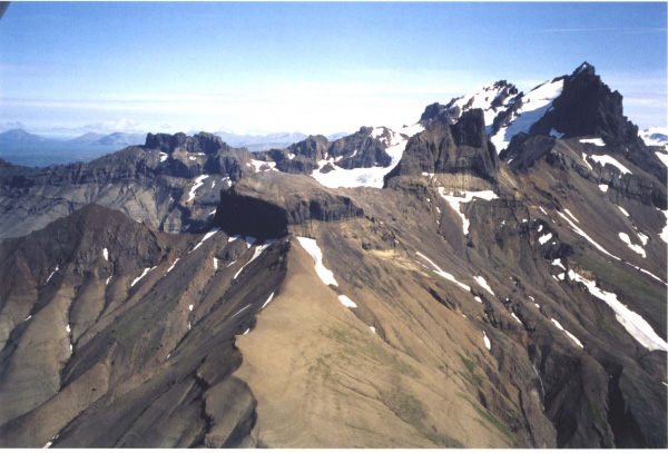
From Wood and Kienle (1990) [1] : "Kejulik is a remnant of a volcano in the southwestern Kejulik Mountains. A radial system of glacially carved valleys surrounds the present topographic high. Extensive glacial erosion has removed most of the lavas, but remnants of lava flows and lahars are preserved on the radial ridges. A series of dikes intrudes the near-horizontal Mesozoic sedimentary rocks beneath the flows. A zone of hydrothermally altered breccia near the present summit marks the former vent of the volcano."Little information has been published on Kejulik. All of the analyzed samples are porphyritic andesites. No recent activity is known."
Name Origin
"Kejulik volcano" is an informal name, derived from the surrounding Kejulik Mountains.
References Cited
[1] Volcanoes of North America: United States and Canada, 1990
Wood, C. A., and Kienle, Juergen, (eds.), 1990, Volcanoes of North America: United States and Canada: New York, Cambridge University Press, 354 p.Loading Past Activity...
Loading Images...
Loading Maps...
Loading Bibliography...
Before an eruption
Ashfall & Preparedness Information
- Ashfall impacts & preparedness (US Geological Survey)
- Volcanic health hazards & impacts (International Volcanic Health Hazards Network)
- Ash Alert! Pamphlet (AK Division of Homeland Security & Emergency Management)
- Volcanic Ashfall (AK Department of Environmental Conservation, Division of Air Quality)