Griggs

MarkerMarkerMarkerMarkerMarkerMarkerMarkerMarkerMarkerMarkerMarkerMarkerMarkerMarkerMarkerMarkerMarkerMarkerMarkerMarkerMarkerMarkerMarkerMarkerMarkerMarkerMarkerMarkerMarkerMarkerMarkerMarkerMarkerMarkerMarkerMarkerMarkerMarkerMarkerMarkerMarkerMarkerMarkerMarkerMarkerMarkerMarkerMarkerMarkerMarkerMarkerMarkerMarkerMarkerMarkerMarkerMarkerMarkerMarkerMarkerMarkerMarkerMarkerMarkerMarkerMarkerMarkerMarkerMarkerMarkerMarkerMarkerMarkerMarkerMarkerMarkerMarkerMarkerMarkerMarkerMarkerMarkerMarkerMarkerMarkerMarkerMarkerMarkerMarkerMarkerMarkerMarkerMarkerMarkerMarkerMarkerMarkerMarkerMarkerMarkerMarkerMarkerMarkerMarkerMarkerMarkerMarkerMarkerMarkerMarkerMarkerMarkerMarkerMarkerMarkerMarkerMarkerMarkerMarkerMarkerMarkerMarkerMarkerMarkerMarkerMarkerMarkerMarkerMarkerMarkerMarkerMarkerMarkerMarkerMarkerMarkerMarkerMarkerMarkerMarkerMarkerMarkerMarkerMarkerMarkerMarkerMarkerMarkerMarkerMarkerMarkerMarkerMarkerMarkerMarkerMarkerMarkerMarkerMarkerMarkerMarkerMarkerMarkerMarkerMarkerMarkerMarkerMarkerMarkerMarkerMarkerMarkerMarkerMarkerMarkerMarkerMarkerMarkerMarkerMarkerMarkerMarkerMarkerMarkerMarkerMarkerMarkerMarkerMarkerMarkerMarkerMarkerMarkerMarkerMarkerMarkerMarkerMarkerMarkerMarkerMarkerMarkerMarkerMarkerMarkerMarkerMarkerMarkerMarkerMarkerMarkerMarker
Legend
Red (Warning)
Orange (Watch)
Yellow (Advisory)
Green (Normal)
Uninstrumented
Community
Webcam
Instrument
Earthquake Magnitude
0 7+
Earthquake Age
Last 2 Hours
Last 2 Days
Last 1 Week


Facts


  • Official Name: Mount Griggs
  • Seismically Monitored: Yes
  • Color Code: GREEN
  • Alert Level: NORMAL
  • Elevation: 2317m (7601ft)
  • Latitude: 58.3572
  • Longitude: -155.1037
  • Smithsonian VNum: 312190
  • Pronunciation:
  • Nearby Towns:
    • Karluk 59 mi (96 km) SE
    • King Salmon 61 mi (98 km) NW
    • Kanatak 64 mi (104 km) SW
    • Larsen Bay 70 mi (113 km) SE
    • Igiugig 73 mi (117 km) NW

    Distance from Anchorage: 268 mi (431 km)

Description

From Wood and Kienle (1990) [1] : "A spectacular, little-dissected cone, Mount Griggs towers 1,700 m above the north margin of the Valley of Ten Thousand Smokes, its summit only 10 km north of Novarupta. Uniquely among the stratovolcanoes of the Katmai district, it lies 10 km behind (northwest of) the remarkably linear (N66E-trending) volcanic front defined by Martin, Mageik, Trident, Katmai, and Snowy Mountain centers.
"Griggs's truncated summit is an expression of 3 concentric craters, the outermost of which is 1.5 km wide, breached to the southwest, and filled by a semi-annulus of ice wrapped around a young central cone containing the nested inner craters. The main outer crater probably originated by early Holocene collapse, and formation of a 1-cubic km-scale debris avalanche, remnants of which survive on the lower west-southwest flank and across the valley on Broken Mountain. Much of the amphitheater was subsequently filled by the nested inner cone. Outer slopes of the main and inner cones expose a few scoria flows and local scoria falls but principally consist of complexes of the thin brecciated lava tongues, overlapping and bifurcating in the manner so characteristic of summit-fed andesites on steep slopes. The total volume of Mount Griggs is ~25 cubic km.
"Griggs's products are chiefly olivine-pyroxene andesites; 27 samples range continuously from 54.5 to 63.5% SiO2. They are consistently more potassic than products of the other Katmai cluster volcanoes, their K2O contents being 1.3-1.4% at 57.5% SiO2 and 1.7-1.9% at 60%. Isotopic data also suggest a source mixture and plumbing system independent of the other nearby centers.
"Numerous SO2-rich fumarolic jets occur between 1,940-m and 2,180-m elevation atop the inner cone and along a steep chute on its upper southwest slope. Orifice temperatures (measured by Dave Johnston in 1978-9) range from 96 degrees to 108 degrees C, and their condensates have pH ~1. Each orifice is constructing its own mound of sulfur sublimate. Downhill fumaroles are hottest and loudest, their roar commonly audible from the valley floor."

Name Origin

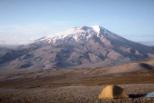
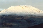
Mount Griggs was named in 1956 by Gilbert Grosvenor, National Geographic Society, for Robert Fiske Griggs (1881-1952), botanist and leader of six National Geographic Society expeditions to the Katma District from 1915 to 1930. These expeditions lead to the 1918 creation of the Katmai National Monument. This volcano was previously called "Knife Peak" (Orth, 1971).


References Cited

[1] Volcanoes of North America: United States and Canada, 1990

Wood, C. A., and Kienle, Juergen, (eds.), 1990, Volcanoes of North America: United States and Canada: New York, Cambridge University Press, 354 p.

Current Activity

No new updates for Griggs volcano since March 18, 2022, 3:33 pm.

Color Code Timeline

Reported Activity

Modern Eruptions

Griggs

Griggs Eruption Timeline

In 1923, Smith (1925) reported Mt. Griggs had active fumaroles, constantly sending "columns of white fumes many hundred feet in the air." This activity does not constitute a volcanic eruption.

Griggs 1953/7

July 1953

From Muller and others (1954): "During July [1953] mild fumarolic activity was reported near the crest of Knife Peak [Griggs] by Lt. James Mulkern, pilot with a topographic survey unit of the Army Corps of Engineers. This peak has no history of more vigorous activity." This activity does not constitute a volcanic eruption.

Keller and Reiser (1959) reported Mt. Griggs "steaming" in 1954. This activity does not constitute a volcanic eruption.

Ward and Matumoto (1967) report seeing a "very active fumarole high on the west flank" of Mt. Griggs during 1965. This activity does not constitute a volcanic eruption.

Griggs 1923

Griggs 1953/7

Griggs 1954

Griggs 1965

1810
1820
1830
1840
1850
1860
1870
1880
1890
1900
1910
1920
1930
1940
1950
1960
1970
1980
1990
2000
2010
2020
2030
2040
2050
2060
1912
1913
1914
1915
1916
1917
1918
1919
1921
1922
1923
1924
1925
1926
1927
1928
1929
1931
1932
1933
1934
1935
1936
1937
1938
1939
1941
1942
1943
1944
1945
1946
1947
1948
1949
1951
1952
1953
1954
1955
1956
1957
1958
1959
1961
1962
1963
1964
1965
1966
1967
1968
1969
1971
1972
1973
1974
1975

5 Event Date(s)

Past Activity Legend:
Eruption
Questionable eruption
Non-eruptive activity


Showing 1 - 20 of 35

Map Images


Map References


Recently active volcanoes of Alaska, 2023

Cameron, C.E., Bull, K.F., and Macpherson, A.E., 2023, Recently active volcanoes of Alaska: Alaska Division of Geological & Geophysical Surveys Miscellaneous Publication 133 v. 6, 2 sheets. https://doi.org/10.14509/31086.

Historically active volcanoes of Alaska, v. 3, 2018

Cameron, C.E., Schaefer, J.R., and Mulliken, K.M., 2018, Historically active volcanoes of Alaska: Alaska Division of Geological & Geophysical Surveys Miscellaneous Publication 133 v. 3, 2 sheets. Http://doi.org/10.14509/30142

Historically active volcanoes of Alaska, 2014

Schaefer, J.R., Cameron, C.E., and Nye, C.J., 2014, Historically active volcanoes of Alaska: Alaska Division of Geological & Geophysical Surveys Miscellaneous Publication 133 v. 1.2, 1 sheet, scale 1:3,000,000. This publication has been superseded. Newest version available at http://www.dggs.alaska.gov/pubs/id/20181 .

Geologic map of the Katmai volcanic cluster, Katmai National Park, Alaska, 2003

Hildreth, Wes, and Fierstein, Judy, 2003, Geologic map of the Katmai volcanic cluster, Katmai National Park, Alaska: U.S. Geological Survey Miscellaneous Investigation Series Map I 2778, unpaged, 1 sheet, scale 1:63,360.
full-text PDF 23.9 MB
Hard Copy held by AVO at FBKS - CEC file cabinet

Preliminary volcano-hazard assessment for the Katmai volcanic cluster, Alaska, 2001

Fierstein, Judy, and Hildreth, Wes, 2001, Preliminary volcano-hazard assessment for the Katmai volcanic cluster, Alaska: U.S. Geological Survey Open-File Report 00-0489, 50 p., 1 plate, scale not applicable.
full-text PDF 28.8 MB
Hard Copy held by AVO at FBKS - CEC shelf

Volcanoes of Alaska, 1998

Nye, C. J., Queen, Katherine, and McCarthy, A. M., 1998, Volcanoes of Alaska: Alaska Division of Geological & Geophysical Surveys Information Circular IC 0038, unpaged, 1 sheet, scale 1:4,000,000, available at http://www.dggs.dnr.state.ak.us/pubs/pubs?reqtype=citation&ID=7043 .
Hard Copy held by AVO at FBKS - CEC shelf

Volcanoes of Alaska, 1995

Alaska Division of Geological & Geophysical Surveys, 1995, Volcanoes of Alaska: Alaska Division of Geological & Geophysical Surveys Information Circular IC 0038, unpaged, 1 sheet, scale 1:4,000,000.

Geologic map of the Mount Katmai quadrangle and adjacent parts of the Naknek and Afognak quadrangles, Alaska, 1994

Riehle, J. R., Detterman, R. L., Yount, M. E., and Miller, J. W., 1994, Geologic map of the Mount Katmai quadrangle and adjacent parts of the Naknek and Afognak quadrangles, Alaska: U.S. Geological Survey Miscellaneous Investigations Series Map I 2204, unpaged, 1 plate, scale 1:250,000.

Geothermal resources of the Aleutian Arc, 1993

Motyka, R. J., Liss, S. A., Nye, C. J., and Moorman, M. A., 1993, Geothermal resources of the Aleutian Arc: Alaska Division of Geological & Geophysical Surveys Professional Report PR 0114, 17 p., 4 sheets, scale 1:1,000,000.
Hard Copy held by AVO at FBKS - CEC shelf

Quaternary geologic map of the Mount Katmai quadrangle and adjacent parts of the Naknek and Afognak quadrangles, Alaska, 1993

Riehle, J. R., and Detterman, R. L., 1993, Quaternary geologic map of the Mount Katmai quadrangle and adjacent parts of the Naknek and Afognak quadrangles, Alaska: U.S. Geological Survey Miscellaneous Investigations Series Map I 2032, unpaged, 1 sheet, scale 1:250,000.

Holocene volcanoes of the Aleutian Arc, Alaska, 1993

March, G. D., 1993, Holocene volcanoes of the Aleutian Arc, Alaska: Alaska Division of Geological & Geophysical Surveys Public-Data File PDF 93-85, unpaged, 1 sheet, scale 1:2,000,000.

Map showing potassium-argon ages from the Mount Katmai and adjacent parts of the Naknek and Afognak quadrangles, Alaska Peninsula, Alaska, 1992

Shew, Nora, and Lanphere, M. A., 1992, Map showing potassium-argon ages from the Mount Katmai and adjacent parts of the Naknek and Afognak quadrangles, Alaska Peninsula, Alaska: U.S. Geological Survey Miscellaneous Field Studies Map MF 2021-E, unpaged, 1sheet, scale 1:250,000.

Preliminary geologic map of the Mt. Katmai quadrangle and portions of the Afognak and Naknek quadrangles, Alaska, 1987

Riehle, J. R., Detterman, R. L., Yount, M. E., and Miller, J. W., 1987, Preliminary geologic map of the Mt. Katmai quadrangle and portions of the Afognak and Naknek quadrangles, Alaska: U.S. Geological Survey Open-File Report 87-0593, unpaged, 1 sheet, scale 1:250,000.
Hard Copy held by AVO at FBKS - CEC shelf

Map showing distribution, composition, and age of Late Cenozoic volcanic centers in Alaska, 1986

Luedke, R. G., and Smith, R. L., 1986, Map showing distribution, composition, and age of Late Cenozoic volcanic centers in Alaska: U.S. Geological Survey Miscellaneous Investigations Series Map I 1091-F, unpaged, 3 sheets, scale 1:1,000,000.

Eruption of Trident Volcano, Katmai National Monument, Alaska, Feb.-June 1953, 1954

Snyder, G. L., 1954, Eruption of Trident Volcano, Katmai National Monument, Alaska, Feb.-June 1953: U.S. Geological Survey Circular C 0318, 7 p., 2 sheets, scale unknown.
Hard Copy held by AVO at FBKS - CEC file cabinet

Loading Bibliography...

Ash Forecasting

Mathematical models developed by the USGS forecast various aspects of how a volcanic ash plume will interact with wind—where, how high, and how fast ash particles will be transported in the atmosphere, as well as where ash will fall out and accumulate on the ground. AVO runs these models when a volcano is restless by assuming a reasonable hypothetical eruption, to provide a pre-eruptive forecast of areas likely to be affected. During an ongoing eruption, AVO will update the forecast with actual observations (eruption start time and duration, plume height) as they become available.

View the current airborne ash cloud models for Griggs

Ashfall thickness forecast

The Ash3d model was developed by the USGS to forecast how a volcanic ash plume will interact with wind and where ash will fall out and accumulate on the ground. AVO runs these models twice daily when a volcano is restless by assuming a reasonable hypothetical eruption altitude and duration. The map shows the model results of ashfall thickness for areas that are likely to be affected, if one were to occur. During an ongoing eruption, AVO will update the forecast with actual observations (eruption start time and duration, plume height) as they become available, and these plots will be automatically updated. The National Weather Service Anchorage Forecast Office will issue the official ashfall warning product and post them at weather.gov/afc

THESE PRODUCTS MAY NOT BE CURRENT.

During an actual eruption, see National Weather Service forecasts of ashfall:https://weather.gov/afc.

Ashfall Forecast

Click on the X on the graphic (upper right) to expand the map to show the map legend.

Ashfall Start Time

This map shows the modeled estimate of the time it would take for ashfall to begin following an eruption. It corresponds to the ashfall thickness forecast map shown above. This map uses the start time of either the twice-daily hypothetical model runs (time shown in the legend) or the actual eruption start time (if one were to occur). In the case of an actual eruption, the National Weather Service Anchorage Forecast Office will issue the official ashfall warning product that includes the ashfall start time and post them at weather.gov/afc

THESE PRODUCTS MAY NOT BE CURRENT.

During an actual eruption, see National Weather Service forecasts of ashfall:https://weather.gov/afc.

Ashfall Start Times Forecast

Click on the X on the graphic (upper right) to expand the map to show the map legend.
×