References
Orr, T.R., Dietterich, H.R., Grapenthin, R., Haney, M.M., Loewen, M.W., Saunders-Schultz, P., Tan, D., Waythomas, C.F., and Wech, A.G., 2025, 2022 Volcanic activity in Alaska and the Northern Mariana Islands-Summary of events and response of the Alaska Volcano Observatory: U.S. Geological Survey Scientific Investigations Report 2024-5108, 46 p. https://doi.org/ 10.3133/sir20245108
Orr, T.R., Dietterich, H.R., Fee D., Girona, T., Grapenthin, R., Haney, M.M., Loewen, M.W., Lyons, J.J., Power, J.A., Schwaiger, H.F., Schneider, D.J., Tan, D., Toney, L., Wasser, V.K., and Waythomas, C.F., 2024, 2021 Volcanic activity in Alaska and the Commonwealth of the Northern Mariana Islands - Summary of events and response of the Alaska Volcano Observatory: U.S. Geological Survey Scientific Investigations Report 2024-5014, 64 p. https://doi.org/10.3133/sir20245014.
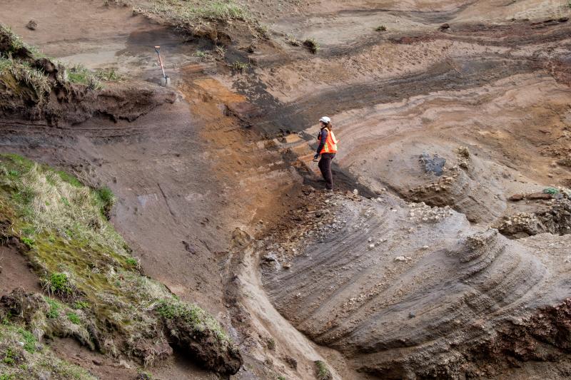
Loewen, M.W., Dietterich, Hannah, and Rosenkrans, H.S., 2023, Davidof volcano samples and analyses: Alaska Division of Geological & Geophysical Surveys Raw Data File 2023-22, 4 p. https://doi.org/10.14509/31084.
Lubbers, J., Loewen, M., Wallace, K., Coombs, M., and Addison, J., 2023, Probabilistic source classification of large tephra producing eruptions using supervised machine learning - an example from the Alaska-Aleutian Arc: Geochemistry, Geophysics, Geosystems v. 24, no. 11, e2023GC011037. https://doi.org/10.1029/2023GC011037.
Cameron, C.E., Crass, S.W., and AVO Staff, eds, 2022, Geologic database of information on volcanoes in Alaska (GeoDIVA): Alaska Division of Geologic and Geophysical Surveys Digital Data Series 20, https://doi.org/10.14509/geodiva, https://doi.org/10.14509/30901.
Ewert, J.W., Diefenbach, A.K., and Ramsey, D.W., 2018, 2018 update to the U.S. Geological Survey national volcanic threat assessment: U.S. Geological Survey Scientific Investigations Report 2018-5140, 40 p., https://pubs.usgs.gov/sir/2018/5140/sir20185140.pdf.
Cameron, C.E., and Snedigar, S.F., 2016, Alaska Volcano Observatory image database: Alaska Division of Geological & Geophysical Surveys Digital Data Series 13, https://www.avo.alaska.edu/images/. https://doi.org/10.14509/29689.
Cameron, C.E., and Nye, C.J., 2014, Preliminary database of Quaternary vents in Alaska: Alaska Division of Geological & Geophysical Surveys Miscellaneous Publication 153, 11 p., doi:10.14509/27357 .
Mastin, L.G., Guffanti, Marianne, Ewert, J.E., and Spiegel, Jessica, 2009, Preliminary spreadsheet of eruption source parameters for volcanoes of the world: U.S. Geological Survey Open-File Report 2009-1133, v. 1.2, 25 p., available at http://pubs.usgs.gov/of/2009/1133/ .
Ewert, John, 2007, System for ranking relative threats of U.S. volcanoes: Natural Hazards Review, v. 8, n. 4, p. 112-124.
Wilson, F.H., Mohadjer, Solmaz, Labay, K.A., Shew, Nora, and Grey, D.M., 2006, Digital data for the reconnaissance geologic map of the western Aleutian islands, Alaska: U.S. Geological Survey Open-File Report 2006-1302, 1 p., available online at http://pubs.usgs.gov/of/2006/1302/
Siebert, L., and Simkin, T., 2002-, Volcanoes of the world: an illustrated catalog of Holocene volcanoes and their eruptions: Smithsonian Institution, Global Volcanism Program Digital Information Series GVP-3, http://volcano.si.edu/search_volcano.cfm, unpaged internet resource.
Cameron, C. E., Triplehorn, J. H., and Robar, C. L., 2003, Bibliography of information on Alaska volcanoes: Alaska Division of Geological & Geophysical Surveys Miscellaneous Publication MP 131, 1 CD-ROM.
Hard Copy held by AVO at FBKS - CEC file cabinet
Simkin, Tom, and Siebert, Lee, 1994, Volcanoes of the world [2nd edition]: Tucson, Arizona, Geoscience Press, 349 p.
Hard Copy held by AVO at FBKS - CEC shelf
Miller, T. P., 1994, Geothermal resources of Alaska: in Plafker, George and Berg, H. C., (eds.), The Geology of Alaska, Geological Society of America The Geology of North America series v. G-1, p. 979-987.
Hard Copy held by AVO at FBKS - CEC file cabinet
Hard Copy held by AVO at FBKS - CEC shelf
Myers, J. D., 1994, The geology, geochemistry and petrology of the recent magmatic phase of the central and western Aleutian Arc: unpublished manuscript unpaged.
Hard Copy held by AVO at FBKS - CEC shelf
Fournelle, J. H., Marsh, B. D., and Myers, J. D., 1994, Age, character, and significance of Aleutian arc volcanism: in Plafker, George and Berg, H. C., (eds.), The Geology of Alaska, Geological Society of America The Geology of North America Series v. G-1, p. 723-758.
Bergsland, Knut, comp., 1994, Aleut dictionary, Unangam Tunudgusii, an unabridged lexicon of the Aleutian, Pribilof, and Commander Islands Aleut language: University of Alaska Fairbanks, Alaska Native Language Center, 739 p.
Wood, C. A., and Kienle, Juergen, (eds.), 1990, Volcanoes of North America: United States and Canada: New York, Cambridge University Press, 354 p.
Hard Copy held by AVO at FBKS - CEC shelf
Luedke, R. G., and Smith, R. L., 1986, Map showing distribution, composition, and age of Late Cenozoic volcanic centers in Alaska: U.S. Geological Survey Miscellaneous Investigations Series Map I 1091-F, unpaged, 3 sheets, scale 1:1,000,000.
Simkin, Tom, Siebert, Lee, McClelland, Lindsay, Bridge, David, Newhall, Christopher, and Latter, J. H., 1981, Volcanoes of the world: Stroudsburg, PA, Hutchinson Publishing Company, 233 p.
Turner, D. L., Forbes, R. B., Albanese, Mary, Macbeth, Joyce, Lockhart, A. B., and Seed, S. M., 1980, Geothermal energy resources of Alaska: University of Alaska Fairbanks Geophysical Institute Report UAG-R 279, 19 p., 3 sheets, scale 1 at 1:2,500,000.
Smith, R. L., and Shaw, H. R., 1979, Igneous-related geothermal systems: in Muffler, L. J. P., (ed.), Assessment of geothermal resources of the United States 1978, U.S. Geological Survey Circular C 790, p. 12-17.
Muffler, L. J. P., 1979, Assessment of geothermal resources of the United States--1978: U.S. Geological Survey Circular C 0790, 163 p.
Hard Copy held by AVO at FBKS - CEC shelf
Smith, R. L., Shaw, H. R., Luedke, R. G., and Russell, S. L., 1978, Comprehensive tables giving physical data and thermal energy estimates for young igneous systems of the United States: U.S. Geological Survey Open-File Report 78-0925, p. 1-25.
Hard Copy held by AVO at FBKS - CEC shelf
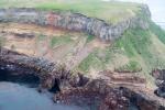
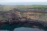
Nelson, W. H., 1959, Geology of Segula, Davidof and Khvostof Islands, Alaska: in Investigations of Alaskan volcanoes, U.S. Geological Survey Bulletin 1028-K, p. 257-266, 2 sheets, scale 1:25,000.
Hard Copy held by AVO at FBKS - CEC shelf
Powers, H. A., 1958, Alaska Peninsula-Aleutian Islands: in Williams, H., (ed.), Landscapes of Alaska, Los Angeles, CA, University of California Press, p. 61-75.
Snyder, G. L., 1957, Ocean floor structures, northeastern Rat Islands, Alaska: in Investigations of Alaskan volcanoes, U.S. Geological Survey Bulletin 1028-G, p. 161-167, 1 plate, scale 1:125,000.
Hard Copy held by AVO at FBKS - CEC shelf
U.S. Department of Commerce, and Coast and Geodetic Survey, 1947, United States coast pilot, Alaska Part 2, Yakutat Bay to Arctic Ocean: Washington DC, United States Government Printing Office, 659 p.