Buldir
| Red (Warning) | |
| Orange (Watch) | |
| Yellow (Advisory) | |
| Green (Normal) | |
| Uninstrumented | |
| Community | |
| Webcam | |
| Instrument | |
| Earthquake Magnitude | |
|
0
| |
| Earthquake Age | |
| Last 2 Hours | |
| Last 2 Days | |
| Last 1 Week | |
Facts
- Official Name: Buldir Volcano
- Seismically Monitored: No
- Color Code: UNASSIGNED
- Alert Level: UNASSIGNED
- Elevation: 656m (2152ft)
- Latitude: 52.3488
- Longitude: 175.909
- Smithsonian VNum: 311010
- Pronunciation:
-
Nearby Towns:
- Shemya Station 80 mi (129 km) NW
- Attu Station 119 mi (192 km) NW
- Adak 318 mi (512 km) SE
- Atka 418 mi (673 km) SE
- Nikolski 638 mi (1027 km) NE
Distance from Anchorage: 1410 mi (2270 km)
-
Subfeatures:
- East Cape
- Kittiwake Pond

Description
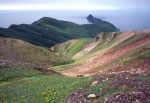
From Wood and Kienle (1990) [1] : "Buldir Island is the westernmost volcanic center of the present Pleistocene to Recent Aleutian volcanic front. The next westward subaerial volcanism is in Kamchatka. Buldir is a small (~2 cubic km), isolated, and mountainous island consisting of two volcanoes, the older of which is Buldir volcano and the younger East Cape volcano. Although broadly of similar age, a significant lapse of time between their formation allowed considerable marine and subaerial erosion, the products of which fill the lowlands. Buldir volcano, which once had a parasitic cone, consists of a few thin (3-m), olivine-bearing, high alumina basalt flows and much volcaniclastic debris. East Cape volcano has two vents: the principal vent forms an eruptive cone cored by a late stage plug, whereas the secondary vent is a large flank dome of hornblende andesite."Buldir Island is unusual in its restricted flora relative to neighboring islands, suggesting that it is comparatively young and not a fragment of a much older, larger subaerial island. The once nearly extinct Aleutian goose (a lesser Canada goose) was rekindled from relict nestings on Buldir."
Name Origin
The name Buldir Volcano, on Buldir Island, was first reported by Coats (1953). Concerning the name of Buldir Island, however, the October 28, 1741 entry in the log book of the St. Peter, commanded by Vitus Bering, reads "by the will of God Stephan Buldirev [later written as Stephan Bogdriev], naval cooper, died of scurvy" (Golder, 1922). The same day Bering named an island "St. Stephen." Many scholars, including Golder, correlate the island of Bering with that of present-day Buldir Island, and, if so, it may have been named for the sailor that died on its discovery day. The name "Ostrov Buldir" was published on a 1791 map by Lt. Sarichev, and thus he may be responsible for the naming (Orth, 1971).
References Cited
[1] Volcanoes of North America: United States and Canada, 1990
Wood, C. A., and Kienle, Juergen, (eds.), 1990, Volcanoes of North America: United States and Canada: New York, Cambridge University Press, 354 p.Reported Activity
Modern Eruptions
0 Event Date(s)
| Eruption | |
| Questionable eruption | |
| Non-eruptive activity |


Map Images
Topographic shaded relief map of Buldir and East Cape volcanoes, Alaska.
Map References
Digital data for the reconnaissance geologic map of the western Aleutian islands, Alaska, 2006
Volcanoes of Alaska, 1998

Volcanoes of Alaska, 1995
Geothermal resources of the Aleutian Arc, 1993

Map showing distribution, composition, and age of Late Cenozoic volcanic centers in Alaska, 1986
Reconnaissance geology of some western Aleutian Islands, Alaska, 1956

Configuration of the Aleutian Ridge: Rat Islands-Semisopochnoi I. to west of Buldir I., 1953
Loading Bibliography...
Before an eruption
Ashfall & Preparedness Information
- Ashfall impacts & preparedness (US Geological Survey)
- Volcanic health hazards & impacts (International Volcanic Health Hazards Network)
- Ash Alert! Pamphlet (AK Division of Homeland Security & Emergency Management)
- Volcanic Ashfall (AK Department of Environmental Conservation, Division of Air Quality)