Trident seismicity information statement July 25, 2023
This Information Statement provides an update on the volcanic unrest at Trident Volcano and the broader Katmai volcanic cluster.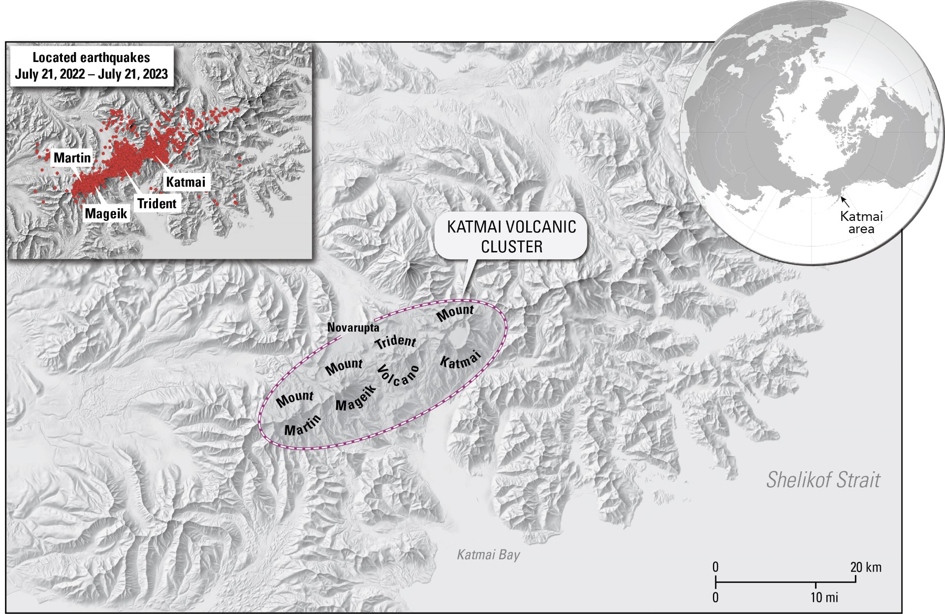
Summary
• The unrest detected over the past five months is a result of magma intrusion beneath Trident Volcano.
• The elevated earthquake rate is also observed at neighboring volcanoes of the Katmai volcanic cluster, including Katmai, Martin, Mageik and the Novarupta vent.
• Some magma intrusions do not result in eruptions, and sometimes the unrest can persist for months or years prior to an eruption.
• If an eruption were to occur, the primary hazard would be from volcanic ashfall and drifting ash clouds, which could disrupt air and marine travel and impact local communities and infrastructure.
• The Alaska Volcano Observatory (AVO) continues to monitor the volcanoes of the Katmai volcanic cluster and will issue further updates as needed.
Current Observations
Rates of earthquakes
Earthquake activity at Trident Volcano has been elevated since August 2022 but has waxed and waned. The initial activity consisted of an unusual series of earthquakes beneath Trident Volcano that progressively migrated over four days from around 16 mi (25 km) below sea level to shallow depths of about 3 mi (5 km) below sea level. In response to this behavior, AVO raised the Volcano Alert Level and Aviation Color Code to ADVISORY/YELLOW on September 29, 2022. After a decrease in seismicity, AVO lowered the Alert Level and Aviation Color Code to GREEN/NORMAL on October 19, 2022.
In November 2022, activity again escalated and consisted of shallow earthquakes less than 5 mi (8 km) below sea level. Most quakes were less than magnitude 1, but dozens of magnitude 2 and 3 earthquakes have occurred. The largest earthquake so far reached a magnitude near 4 on November 20, 2022. The earthquake rate averaged between 10 to 20 daily earthquakes, occasionally reaching rates several times higher. This level of seismicity persisted into February 2023, prompting AVO to raise the Aviation Color Code to YELLOW and the Volcano Alert Level to ADVISORY on February 22, 2023.
Low-frequency earthquakes under Trident
In May 2023, AVO began detecting a marked increase in low-frequency earthquakes—in addition to regular earthquakes—at shallow and deep levels in the region between Trident and Novarupta, which lies 3 mi (5 km) to the northwest. These types of earthquakes often indicate the movement of magma or magmatic fluids within the Earth’s crust. The shallow, low-frequency events occur about 2.5 mi (4 km) north of Trident Volcano at the same depths as the regular earthquakes, around 3 mi (5 km) below sea level. The deep, low-frequency events span a broader area between Trident and Novarupta and occur 18.5 to 22 mi (30 to 35 km) below sea level. These deep low-frequency earthquakes are often accompanied by longer-duration bursts of continuous tremor, indicating deep fluid movement.
Other monitoring data
Ground uplift at Trident Volcano has also been detected in satellite radar data. Snow cover prohibits winter observations, which limits our ability to provide precise timing, but data from June 3, 2023, indicates that about 2 in (5 cm) of ground uplift has occurred since October 6, 2022. Uplift is most significant on the volcano’s south flank.
There have been no visual changes to the ground surface or hydrology. No gas emissions or temperature changes have been observed.
Prognosis
The presence of regular earthquakes, tremor, low-frequency earthquakes, and ground uplift indicates that magma has moved upwards beneath Trident Volcano. Migration of magma beneath the volcano increases the likelihood of an eruption. A stress increase in the Earth's crust caused by magma intrusion and related uplift is likely causing earthquakes.
Intrusions of new magma under volcanoes only sometimes result in volcanic eruptions. The ground uplift and earthquake activity at Trident Volcano may cease with no eruption. Similar episodes of unrest at other volcanoes worldwide end in eruptions about half the time. Unrest in volcanic systems like Trident sometimes lasts many months or years. Unrest could wax and wane, and if an eruption were to occur, it could be after months or years.
Specific types of unrest usually precede eruptive activity allowing AVO to provide advance warning. As magma gets closer to the Earth’s surface, changes in the ground uplift pattern, increased earthquake activity, increased ground surface temperatures, and possible gas emissions would be likely.
Unlike many active volcanoes, which consist of a large cone formed from repeated eruptions from a single vent, Trident eruptions tend to issue from new vents and form individual cones or domes. A new vent was formed during the most recent Trident eruption from 1953 to 1974. Therefore, if an eruption occurs, it is uncertain exactly where the vent would be, though monitoring data will likely help pinpoint the site as magma rises closer to the Earth’s surface.
Seismic activity at nearby volcanoes
Earthquakes are typically located in three regions within the Katmai volcanic cluster: Trident and Novarupta volcanoes, Mount Katmai to the northeast, and Martin and Mageik volcanoes to the southwest. Coincident with the unrest at Trident, earthquakes have also increased beneath Martin and Mageik volcanoes. However, the initial sequence of deep earthquakes and continued episodes of low-frequency earthquakes and tremor are concentrated beneath Trident. The increased seismicity observed at Martin and Mageik volcanoes may be a secondary effect due to magma movement beneath Trident Volcano.
Potential hazards
If an eruption were to occur at Trident, the primary hazard would be from volcanic ashfall and drifting ash clouds, which could disrupt air and marine travel and impact local communities and infrastructure. The areas impacted by ashfall and drifting ash clouds would depend on the wind direction during the eruption.
Areas closer to the eruption site, especially near the edifice, could experience additional hazardous phenomena, such as ballistics (rocks forcibly ejected from the vent) or pyroclastic flows. Pyroclastic flows and hot ash could also fall on or erode snow-covered slopes, leading to volcanic mudflows or lahars in the volcano's drainages.
For a full description of volcanic hazards associated with Trident Volcano, please see the following report: Trident Volcano preliminary hazard assessment
Current monitoring
AVO monitors Trident Volcano and other volcanoes in the Katmai volcanic cluster with a local network of seismometers, infrasound sensors, a webcam, remote sensing data, and regional infrasound and lightning networks.
• To view information about Trident Volcano: Trident Volcano activity page
• Web camera that shows Trident: Trident Volcano webcam
• Location map showing Trident and the Katmai volcanic cluster: Trident Volcano location map
Trident is one of the Katmai group of volcanoes located within Katmai National Park and Preserve on the Alaska Peninsula. Trident consists of a complex of four cones and numerous lava domes, all andesite and dacite in composition, that reach as high as 6,115 ft (1.9 km) above sea level. An eruption beginning in 1953 constructed the newest cone, Southwest Trident, and four lava flows on the flank of the older complex. This eruption continued through 1974 and produced ash (an initial plume rose to 30,000 ft or 9.1 km above sea level), bombs, and lava at various times. Fumaroles remain active on the summit of Southwest Trident and on the southeast flank of the oldest, central cone. Trident is located 92 miles (148 km) southeast of King Salmon and 273 miles (440 km) southwest of Anchorage.