Cleveland satellite images
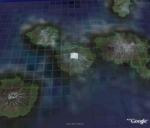
On the morning of Friday, July 20, an intense thermal anomaly and an associated steam plume were observed at Cleveland volcano in a satellite image, suggesting that low-level eruptive activity was occuring. At that time the aviation color code was increased to Orange, and the volcano alert level was increased to Watch. Shown here is an AVHRR image from July 23 placed as an overlay on a Google Earth image. The large white pixel at the summit of Cleveland Volcano identifies the location of the thermal anomaly over the 1.1 km
2 region. Also shown
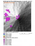
above is a more recent, more detailed, ASTER satellite image from July 25th. Varying shades of magenta colored, 30m
2 pixels indicate surface temperatures ranging from 9 C - 44 C along the upper flanks of Cleveland. Multicolored (red, yellow, green, blue), 15m
2 pixels indicated summit temperatures ranging from 241 C - 359 C. No ash emissions have been detected in satellite data since October 2006, but the possibility of an explosion sending an ash cloud to heights in excess of 20,000 ft above sea level has increased.
The lack of a real-time seismic network at Cleveland means that AVO is unable to track local earthquake activity related to volcanic unrest. Short-lived explosions with ash plumes that could exceed 20,000 ft above sea level can occur without warning and may go undetected in satellite imagery. Follow the links below to additional information.
http://www.avo.alaska.edu/activity/Cleveland.php http://www.avo.alaska.edu/volcanoes/volcimage.php?volcname=Cleveland