| Red (Warning) | |
| Orange (Watch) | |
| Yellow (Advisory) | |
| Green (Normal) | |
| Uninstrumented |
Aleutians
(52.0765, -176.1109)2025-04-18 18:44:28 UTC
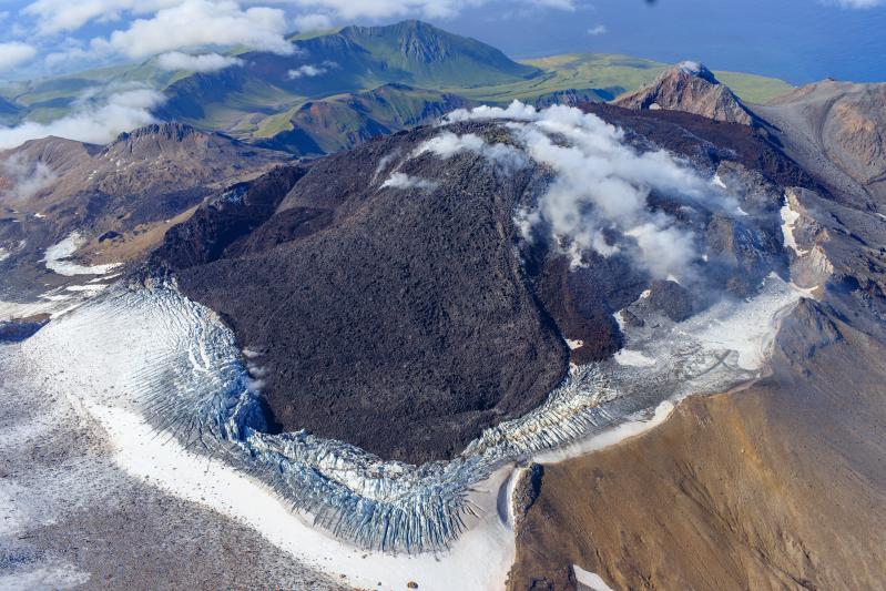
Activity at Great Sitkin Volcano continued over the past week, characterized by the slow eruption of lava in the summit crater. Satellite radar data (which can see through clouds) from April 17 shows lava flow inflation and subtle advance of the lava flow front to the east and south-east compared to previous data from April 6. Intermittent, small volcanic earthquakes continue to occur. Other satellite and web camera observations were mostly obscured by clouds over the past week.
Since the May 2021 explosion, there have been no other explosions at Great Sitkin Volcano. The lava eruption that began in July 2021 is ongoing. It has filled most of the summit crater and advanced into valleys below. The volcano is monitored using local seismic and infrasound sensors, satellite data and web cameras, and regional infrasound and lightning networks.
Cook Inlet-South Central
(61.2989, -152.2539)2025-04-18 18:44:28 UTC
AVO released an updated Information Statement on April 17 that summarized and updated observations, interpretations, and possible outcomes. Based on the recent modest changes in monitoring data and the inability to measure gas for the last month, the outcome of the current unrest is less certain. The likelihood of an eruption has decreased from March, but the volcano remains at an elevated level of unrest and an explosive eruption (or eruptions) like those that occurred in 1953 and 1992 is still possible.
The current unrest at Mount Spurr volcano is characterized by ongoing earthquake activity. Seismicity remains elevated above background with 52 located earthquakes over the last week. Earthquake rates have shown variability during this current period of unrest. Ground deformation at Mount Spurr has slowed over the past three weeks, like the pause in deformation observed for several weeks in November and December, 2024.
No sulfur dioxide emissions were detected in satellite data over the past week and an overflight of the volcano to measure gas emissions is planned for the next good weather day. Steaming from the summit continues to be observed in web camera images during periods of clear viewing conditions. High resolution satellite data from this past week show continued collapse of ice from the summit crater wall into the summit crater lake. The Mount Spurr monitoring network is functioning well. New snowfall this week has covered up the CKT web camera, but other web cameras (like SPCR) are snow free and functioning well. A new livestream of Mount Spurr, as viewed from Glen Alps in Anchorage, is available here: Mount Spurr Live Stream (ANCG).
AVO continues to closely monitor activity at Mount Spurr for signals indicating the volcano is moving closer to an eruption using local seismic, infrasound, and GNSS stations, web cameras, airborne and satellite gas measurements, regional infrasound, lightning networks, and satellite images. Based on previous eruptions, additional changes in earthquakes, ground deformation, the summit lake, and fumaroles would be expected if magma moves closer to the surface. Therefore, if an eruption occurred, it would be preceded by additional signals that would allow advance warning.