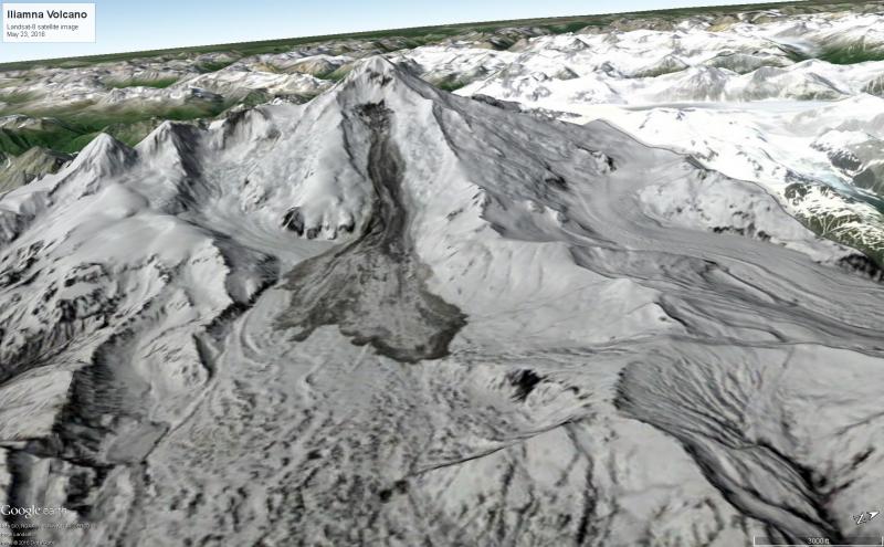
Landsat-8 true color satellite image collected on May 23, 2016 showing the source and deposit extent of a mixed ice, snow and rock avalanche covering part of Red Glacier on the east flank of Iliamna Volcano. The avalanche began shortly before midnight on May 21, 2016 (AKDT) and was detected in seismic and pressure sensor data at sites throughout Cook Inlet and the northern Alaska Peninsula. The deposit covers about 7.2 square kilometers (2.75 square miles).
Volcano(es): Iliamna
Photographer: Schneider, David
URL: avo.alaska.edu/image/view/95601
Iliamna 2016/5
From Cameron and others, 2020: "Members of the public noted typical amounts of steaming from the near-summit fumaroles at Iliamna Volcano, particularly in March 2016, and a large landslide occurred May 22. Iliamna remained at Aviation Color Code and Volcano Alert Level GREEN and NORMAL, respectively, throughout 2016.
"Radio station KSRM in Soldotna, Alaska, contacted AVO on Saturday, March 12, stating that people on the Kenai Peninsula could see 'quite a plume' coming from Iliamna Volcano. AVO noted no anomalous seismicity or evidence of increased steaming in satellite data. Web camera imagery showed white vapor and gas plumes rising from the volcano’s prominent and long-lived fumaroles. When Iliamna Volcano is backlit in the evening hours, as viewed from the Kenai Peninsula in spring and fall, its normal fumarolic plume often appears more prominent.
"At 07:58 UTC May 22 (11:58 pm May 21 AKDT), AVO detected seismic and pressure sensor signals associated with a large avalanche on the flank of Iliamna Volcano. Seismic signals from the avalanche were detected on volcano monitoring networks throughout Cook Inlet and as far away as the Mount Katmai area, 250 km (155 mi) southwest. The event was also recorded on distant infrasound stations in Dillingham, Alaska, 326 km (202 mi) and Fairbanks, Alaska, 610 km (379 mi) southwest and northeast of Iliamna Volcano, respectively. AVO issued an Information Statement about the landslide on Sunday, May 22. The sizeable avalanche covered about 7.2 km2 and extended down the east flank of the volcano (fig. 7; Dave Schneider, USGS, written commun., 2016)"
Use Restriction: Please cite the photographer and the Alaska Volcano Observatory / U.S. Geological Survey when using this image.
Full Resolution.