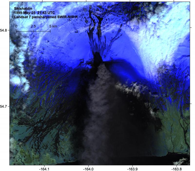
Landsat-7 pansharpened false color (shortwave infrared-R, near infrared-G, red-B bands) from May 25, 1999 showing an ash-rich eruption plume driving south, flowage deposits to the north, and extensive dark tephra deposits from earlier eruptions to the south. The image was acquired during testing and calibration of the Landsat-7 satellite shortly after its launch.
Volcano(es): Shishaldin
Photographer: Loewen, M. W.
URL: avo.alaska.edu/image/view/163481
Shishaldin 1999/9
From Neal and others (2004): "Following anomalous, post-eruption seismicity of late December 1999, a series of seismic events caused by small explosions were identified on January 15, 2000. No associated plumes or thermal anomalies appeared on satellite images. Re-analysis of seismic data for the previous several months revealed that similar small 'explosion' seismic signals had been occurring intermittently since September 1999, several months after the end of the main phase of the 1999 eruptive activity (Nye and others, 2002). The January events were low-level and difficult to discern during the frequently inclement weather when background noise was high. The explosions prompted AVO to mention the change in the weekly update, however, the level of concern color code remained GREEN (table 4.) On January 28 and 29, vigorous steam plumes were observed rising up to about 3,000 ft (1,000 m) over Shishaldin. By early February, the frequency and amplitude of the overall seismicity, including the explosion events, had increased (up to 200 per day) and were accompanied by reports of vigorous steam plumes. The activity was interpreted to be small phreatic explosions within the cone's deep central crater. Noting that a similar pattern had developed in February 1999 prior to the onset of strombolian eruptive activity, AVO upgraded the color code to YELLOW on February 3. Fortuitously, the number of seismic events abruptly decreased the next day. The color code was lowered to GREEN on February 18. A small steam plume was observed in satellite images on February 22 that extended 15-20 km (9-12 mi) east of the volcano, and small, low-frequency seismic events continued through the spring.
"Satellite analysis detected a few weak thermal anomalies in the summit crater through the spring and summer of 2000. On occasion, steam plumes extended up to 15 km (9 mi) from the summit. In early May, a significant increase in the number of small, low-frequency earthquakes was recorded, however no attendant change in thermal character or visual observations was noted, and
seismicity declined by the end of summer. AVO mentioned both the seismicity and thermal anomalies in weekly updates for a period of one month, but remained at Level of Concern Color Code GREEN for the remainder of the year."
Please cite the photographer and the Alaska Volcano Observatory / U.S. Geological Survey when using this image.
Full Resolution.