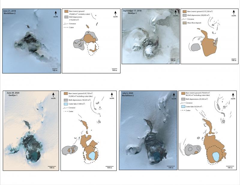
Satellite image views of the summit of Makushin volcano from 2018 and 2020. The images show the extent of bare ground and various melt depressions at the summit. Should unrest-related heat flux at the Makushin summit begin to increase, the extent of bare ground and the number and size of melt depressions should also increase. The recent unrest at the volcano does not appear to have resulted in a change in heat flux as the conditions in 2020 are similar to those in 2018 when the volcano was quiet. Satellite image data courtesy of USGS NEXTView license.
Volcano(es): Makushin
Photographer: Waythomas, Chris
URL: avo.alaska.edu/image/view/159661
Makushin 2020/6
On June 15, 2020, AVO raised the Aviation Color Code and Volcano Alert Level at Makushin to YELLOW/ADVISORY, due to two earthquakes larger than magnitude 4 in the vicinity of Makushin Volcano. This represents a significant departure from background earthquake activity and may be associated with volcanic unrest. This unrest could result a future eruption, however that is not a certainty.
On June 30, 2020, AVO issued an Information Statement about unrest at Makushin, stating "Over the past two weeks, there has been increased earthquake activity at Makushin Volcano. The activity started on June 15 with a magnitude 4.2 earthquake, followed over the next 24 hours by several additional significant earthquakes ranging in magnitude from 3.1 to 4.1. These larger earthquakes have been accompanied by hundreds of smaller earthquakes located by AVO that are continuing up to the present time. The rate of occurrence and size of the earthquakes initially declined for about a week following the magnitude 4.2 earthquake. However, since June 24, the rate and size of the earthquakes has fluctuated with the most recent increase associated with two earthquakes of magnitude 3.0 and 3.8 that occurred at 4:53 PM and 6:02 PM on June 28. All of the earthquakes are clustered about 10 km (6 miles) east of the summit of the volcano at a depth of about 8 km (5 miles). The largest earthquakes have been felt strongly by residents of Unalaska.
"The exact cause of this increased earthquake activity, in terms of possible volcanic or tectonic processes, is uncertain at this time. The earthquakes may be related to the movement of magma beneath the east side of Makushin Volcano, interactions between an earthquake fault and the nearby geothermal field, the activation of more than one fault in this area, or a combination of these scenarios. Because of the distance and depth of the locations of the earthquakes from the summit of Makushin Volcano, and the absence of other forms of volcanic unrest such as increased steaming, gas emission, or ground deformation, there is no indication that the present earthquake sequence will necessarily lead to a volcanic eruption."
Please cite the photographer and the Alaska Volcano Observatory / U.S. Geological Survey when using this image.
Full Resolution.