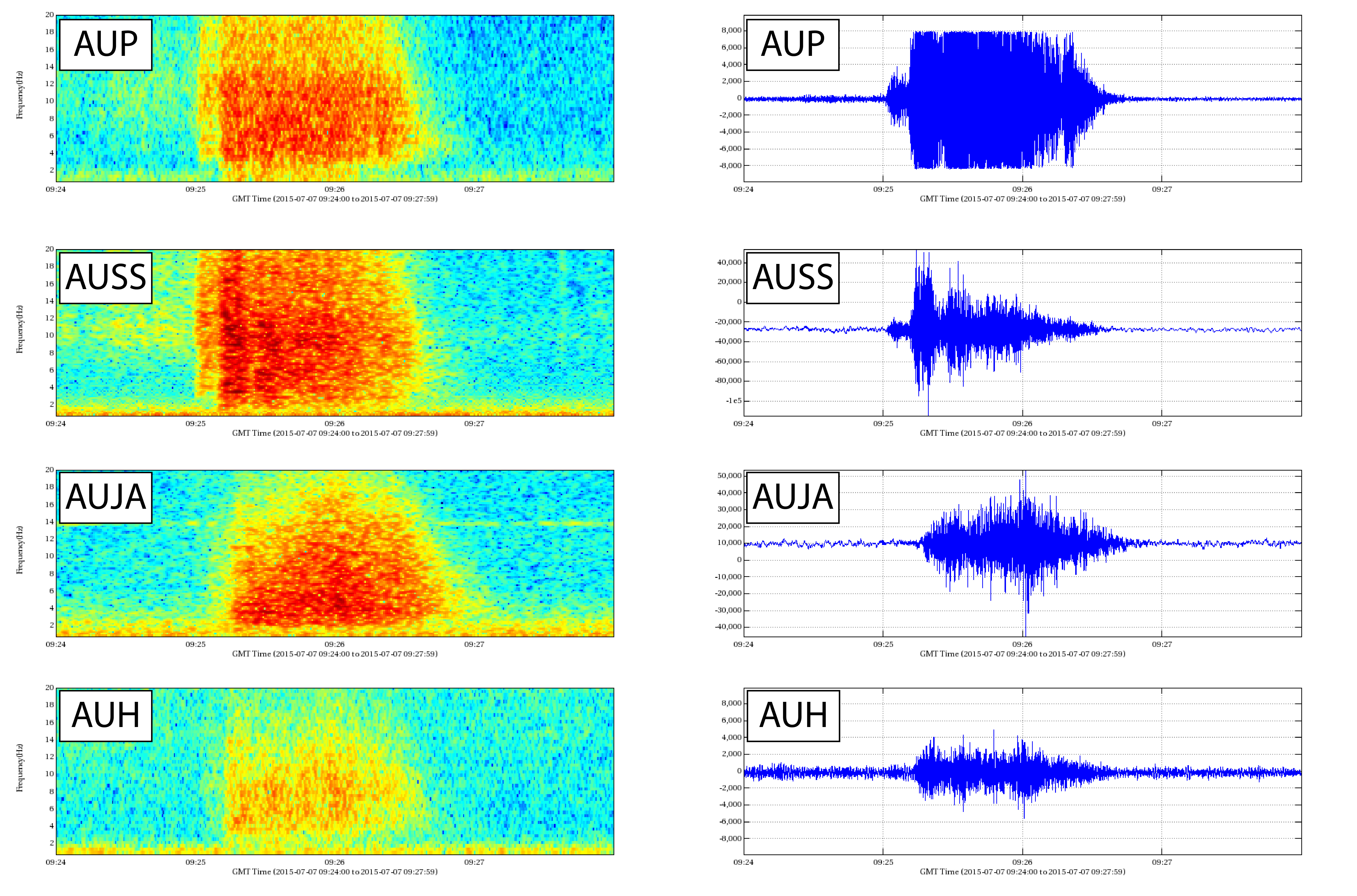
Possible rockfall event at Augustine, July 7, 2015, 09:25 UTC (1:25 AKDT). The signal at four Augustine seismograph stations are shown with the rockfall first showing at summit stations AUP and AUSS and later at AUJA and AUH on the flank of the volcano. The frequency of the signal from 0-20Hz is shown on the spectrograms on the right, and the waveforms with counts +/- 10K for the short-period stations ( AUP, AUH) and +/- 45-65K for the broadband stations (AUJA, AUSS). The length of the signals in all images are four seconds long. Data publicly available from http://ds.iris.edu/mda/AV
Volcano(es): Augustine
Photographer: Dixon, Jim
URL: avo.alaska.edu/image/view/97611
Augustine 2015
From Dixon and others, 2017: "Minor unrest occurred at Augustine Volcano in 2015 in the form of visible vapor plumes and rockfalls. In collaboration with Cascade Volcano Observatory (CVO), in June AVO installed a Multiple component Gas Analyzer System (MultiGAS) instrument at the summit of Augustine, designed to measure carbon dioxide (CO2), sulfur dioxide (SO2), and hydrogen sulfide (H2S). The Aviation Color Code/Volcano Alert Level remained GREEN/NORMAL throughout the year.
"Augustine has active fumaroles that often are visible under favorable atmospheric conditions. A gas measuring/sampling flight on April 3 detected low levels of water (H2O), CO2, SO2, and H2S, indicating that Augustine continues to degas at a low rate. The typical vapor plume at Augustine was often visible in web camera images during 2015, and was noted in satellite daily checks on January 25 and July 9. AVO received a PIREP of steam at Augustine on July 9.
"Twenty-two instances of rockfalls occurred at Augustine in 2015 as identified by emergent signals recorded on Augustine seismograph stations: this was twice the number of rockfalls reported in 2014. These rockfalls were concentrated during the months of June, July, August, and October. Rockfall signals at Augustine typically have an emergent onset and appear first at summit stations AUP and AUSS (fig. 5 [original text]).
"On June 12 and 13, AVO and CVO scientists installed a new, permanent MultiGAS/ seismograph station near the summit of Augustine. The MultiGAS instrument (fig.6) was designed and built at CVO, and includes sensors to intermittently measure CO2 and H2S. Data from these sensors are transmitted to AVO in near real time. A broadband seismograph station was installed near the MultiGas station at this time. Two months later another broadband seismograph station was added to the Augustine seismograph network."
Full Resolution.