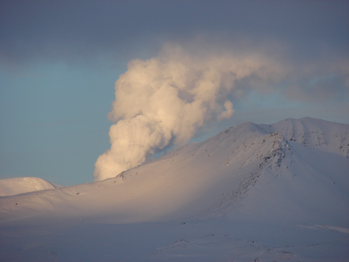
Telephoto image showing a robust, continuous plume of water vapor rises from Korovin volcano, December 24, 2006. Telephoto image taken by Lynne Moore (used with permission) of Atka Village.
Volcano(es): Atka volcanic complex Korovin
Photographer: Cervelli, Peter
URL: avo.alaska.edu/image/view/12544
Korovin 2006/1
From Neal and others (2009): "Beginning on January 16, a brief (minutes-long) increase over this background level was noted. Additional bursts of tremor-like signals occurred on January 17-18, 21, and February 21-22, prompting AVO to raise the Level of Concern Color Code to YELLOW. Satellite imagery of the volcano showed nothing unusual, although clouds frequently obscured the region. AVO did not receive reports of activity from residents of Atka Village, despite periods of clear weather in late February.
Seismicity stabilized and then decreased in early March, and AVO downgraded the Level of Concern Color Code to GREEN on March 8. Clear satellite looks and overflights by commercial pilots indicated no significant surface changes in the vicinity of Korovin. In the spring, there were several week-long outages where fewer than the minimum number of stations required to locate earthquakes were operational.
"The number of earthquakes in the vicinity of Korovin began to increase again in July. Episodes of volcanic tremor were recorded again in September and October, increasing in number, strength, and duration into the fall. White plumes of water vapor reaching several hundred meters above the volcano were photographed from Atka on October 29 [see fig. 44 in original text], about coincident in time with a strong tremor burst about 5 minutes in duration captured on the Korovin network. The shallow lake in the main Korovin crater, present on September 12 according to satellite data, had disappeared by October 19, and remained absent through the end of the year. On November 5, the strongest earthquake swarm ever recorded by the AVO seismic network occurred. AVO decided to upgrade the level of concern for Korovin, based on this sustained increase in seismic activity and visual confirmation of increased fumarolic activity and disappearance of the lake. Utilizing the new warning scheme adopted by the United States Volcano Observatories in October, AVO declared Aviation Color Code YELLOW and Volcanic Activity Alert Level ADVISORY for Korovin on November 6.
"Seismicity at Korovin remained above background through the year's end. Periodic strong, short-duration (tens of seconds to several minutes) signals recorded on the entire network may have been phreatic explosions or sudden hydrothermal boiling events. Similarly, several-minute-long, low-frequency tremor bursts at rates of several per hour occurred intermittently. ASTER satellite images from November 18 indicated an exposure of dark-gray ash on the eastern flank of Korovin's main crater [see fig. 45 in original text]; this ash was not present in a similarly clear image from November 21. Still, it is not known exactly when and by what process ash was emitted from Korovin; it also is possible that the ash visible in satellite imagery represents remobilization of older ash high on the cone, as may have been photographed during fieldwork in 2004 [see figs. 46 and 47 in original text]. Thermal bands in ASTER imagery showed warm areas in the Korovin crater, not a surprise given the known, ongoing fumarolic activity within the crater [see fig. 46 in original text].
"In late November, AVO learned that the Korovin volcano area had undergone significant deformation during the second half of the year. InSAR results comparing data from July and October 2006 for Korovin indicated a very prominent, circular pattern of uplift of as much as 5 cm (2 in) centered about 5.5 km (3.4 mi) southwest of Korovin (see fig. 48 in original text; Z. Lu and P. Cervelli, USGS, written commun., 2006). This location generally is consistent with locations of earthquake swarms beginning in the summer. Two possible explanations for this uplift were considered: (1) a pressurizing and inflating hydrothermal system, plausible given the robust, disseminated hot springs around Korovin and neighboring Kliuchef volcanoes (Motyka and others, 1993) or (2) a rising magmatic intrusion and related deformation.
"Residents of Atka continued to photograph particularly large, at times 'puffing' white-vapor plumes emanating from Korovin on December 11, 21, and 24 [see figs. 49 and 50 in original text]. At least one of these reports suggested the possibility of ash within the plume; the observer further clarified that he saw ash falling below the cloud after it attained some altitude. Ash on the ground was not verified. Satellite data did not detect any rise in ground temperature nor any ash in the atmosphere or on the ground through the end of 2006.
"AVO tracked activity at Korovin using seismic and satellite data. Several times during the year, AVO staff contacted Atka residents by telephone or email to gather additional observations or clarify AVO reports. In February, AVO asked Peninsula Airways (Pen Air) pilots flying into Atka to pass along any pertinent observations. On February 22, Pen Air reported no sign of ash or anything unusual at the volcano."
From McGimsey and others (2011): Korovin Volcano on Atka Island in the west-central Aleutians began 2007 in Aviation Color Code YELLOW and Volcano Alert Level ADVISORY following an upswing in activity during 2006 (Neal and others, 2008). A relatively high level of background seismicity has been prevalent since the AVO network was installed in 2004, and a higher level of seismicity that began in 2006 continued into the first half of 2007 [see figs. 45 and 46 in original text].
"Reports of steam clouds on December 24, 2006, were followed on January 11, 2007, by a M3.5 earthquake at Korovin, which is considered quite large for volcano-generated seismicity. A swarm of likely associated events were recorded during the week; however, a M8.2 earthquake in the Kurile Islands on January 12 (AKST) also may have triggered seismicity at Korovin.
"On January 23, a series of tremor bursts were recorded, and on January 24, AVO received photographs from an Atka Village resident of a steam column rising from Korovin's active crater [see fig. 47 in original text]. The observer reported similar steam columns rose up to about 1,000 ft (about 300 m) above the volcano every 15 to 80 minutes. Satellite images from the previous week indicated that the intermittent lake in Korovin's active crater was not present. Previously, in late September or early October 2006, the lake disappeared following a strong episode of steam emission. The lake had not re-appeared as of mid-January 2007.
"The next report of activity at Korovin came on the afternoon of February 14 when NWS contacted AVO to pass on a PIREP from a U.S. Coast Guard C-130 of a steam plume extending 5,000-8,000 ft (about 1,500-2,400 m) over Korovin. A SIGMET was not issued.
"A couple of weeks later, Atka Village residents Lynn and Kerry Moore sent photographs to AVO taken on March 3 of an ash deposit on the west flank of Korovin [see fig. 48 in original text]. Prior to taking the photographs, the Moores observed steam rising from the active, south summit vent. No anomalous activity was noted in AVO satellite reports for that day; however, a flurry of low frequency seismicity occurred that morning, comparable to seismicity of the last few months. Phreatic activity at Korovin produced similar ash deposits in 2004 and 2006 (Neal and others, 2008).
"Episodes of tremor occurred over several days in May, June, and August, and a thermal anomaly was detected in satellite images in early August. Steam plumes were observed by residents in Atka Village in late July [see fig. 49 in original text]. The satellite-based Ozone Monitoring Instrument (OMI) detected a small SO2 cloud located about 300 km (186 mi)north of Cleveland volcano on August 5, 2007, that likely originated at Korovin based on wind dispersal models. An aerial photograph taken that day shows a steam plume wafting from the crater (fig. 50). On August 19, a flurry of 33 detected seismic events located 4 km (2.5 mi) southeast of Kliuchef was detected [see figures 50 and 52 for location of Kliuchef, 6.5 km (4 mi) south of Korovin]. This was followed on August 20 by a small emission of SO2 from Korovin that was detected by OMI [see fig. 51 in original text].
"Inflation beneath the northern part of Atka Island that began in June 2006 and totaled 9-10 cm (3.5-3.9 in.) of uplift, had begun to taper off in 2007 (Zhong Lu and Peter Cervelli, USGS, written commun., 2007). An InSar interferogram acquired July 1, 2007, shows a distinct but weakened anomaly still centered on the west flank of Kliuchef volcano [see figs. 52 and 53 in original text]. Seismicity over the same period appears to have tracked the uplift (P. Cervelli, USGS, written commun., 2007); compare the area of uplift with the located seismicity in figure 53.
"The decreasing trends of seismicity and uplift prompted AVO to begin considering a status change for the volcano, which had been at Aviation Color Code YELLOW and Volcano Alert Level ADVISORY since November 6, 2006. On September 7, 2007, the Aviation Color Code/Volcano Alert Level was downgraded to GREEN/NORMAL. Although circuit problems plagued the Atka Island network on several occasions, activity at Korovin was uneventful for the remainder of 2007.
"AVO tracked activity at Korovin using seismic and satellite data, and occasional pilot reports. Several times during the year, AVO staff contacted Atka residents by telephone or email to gather additional observations or clarify AVO reports."
Please cite the photographer when using this image.
Full Resolution.